Texas kids test particularly badly in this part of U.S. history. Several districts ask U.S. history teachers and other social studies groups to shore up student knowledge in the area to overcome gaps pointed out in testing in the past three years, on the Texas Assessment of Knowledge and Skills (TAKS). In teacher training, I’ve noted a lot of Texas social studies teachers are a bit shaky on the history.
The Korematsu decision was drummed into my conscious working on civil rights issues at the Senate Labor and Human Resources Committee, and complemented by Constitutional Law (thank you, Mary Cheh) and other courses I was taking at the same time at George Washington University. It helped that Utah has a significant Japanese population and had “hosted” one of the internment camps; one of my tasks was to be sure committee Chairman Orrin Hatch was up on issues and concerns when he met with Japanese descendants in his constituencies in Utah. Hatch was a cosponsor of the bills to study the internment, and then to apologize to Japanese Americans affected, and pay reparations.
The internment was also a sore spot with my father, G. Paul Darrell, who witnessed the rounding up of American citizens in California. Many of those arrested were his friends, business associates and acquaintances. Those events formed a standard against which he measured almost all other claims of civil rights violations.
Because children were imprisoned with their parents, because a lot of teenagers were imprisoned, this chunk of American history strikes particular sympathetic chords with students of any conscience. Dorothea Lange’s having photographed some of the events and places, as well as Ansel Adams and others, also leaves a rich pictorial history.
(Click on thumbnail for a larger view of this Caddoland Collage)
Caddos, Anadarkoes, Tawaconies, Southern Delawares — so many Native American tribes disappear from U.S. history books, and from U.S. history. These histories should be better preserved and better taught.
Texas history texts mention the Caddo Tribe, but largely ignore what must have been a significant cultural empire, if not an empire that left large stone monuments. Teaching this material in Texas history classes frustrates me, and probably others. Student projects on the Caddos are frequently limited in what they cover, generally come up with the same three or four factoids and illustrations.
The Caddo Tribe lived in an area spanning five modern states, Louisiana, Texas, Arkansas, Oklahoma, and eventually Missouri. Here is an interactive map that offers more information and useful photos of Caddoland than I have found in any other source: The Caddo Map Tool.
This is just an image of the tool — click on the image above and it will link to the actual site. One of the things that excites me about this map is its interactive features, especially the map that carries links to photos that show just what the local environment looks like.
The British Broadcasting Company (BBC) puts genius into their website — very often, it seems to me.
Go see this interactive map. It shows where civilizations or religions held sway, at a point in history you decide — and then projects forward to show how the group’s influence waxed and waned. Or plot two different groups, side-by-side.
It uses web technology to reveal the sweep of historical forces and the rise and fall of great empires and ideas over 5000 years in a way that no book could ever do.
And it does it your way. You can customise Civilisations to show you the things that interest you. The best way to understand Civilisations is to have a go.
Great bauble for world geography and world history courses — what sort of a warm-up exercise could you make with this, projecting it from your computer? What sort of homework could be made from this, for the kids to access on their own?
Gee, while you’re there, teachers: Take a look at the interactive quizzes on world religions — this could be a unit all to itself.Hook up your computer, take the quizzes as a class, on that rainy day when you were supposed to go out to look at the school’s garden and you need a ten-minute, cultural filler that sticks to the state standards. And look at this multifaith calendar. You can use it for your daily “this day in history” feature; it’s useful for students doing projects on various religions. Use some imagination.
Spread the word; friends don't allow friends to repeat history.
Here is a great exercise in applied geography: “The Sweet Tea Line” at Neatorama, with a link to Eight Over Five with a wonderful set of interactive maps — though, if you go to the Eight Over Five site, you don’t find any link to this particular map (can anyone explain?).
What about regional variations in food, language, customs or commerce in your state? I remember discovering that “regular coffee” in western Massachusetts meant coffee with a lot of cream and sugar. Not so at Boston’s Logan Airport. Where is the line? What about the lines of where a soft drink is “a pop,” versus “a soda pop,” versus “a coke,” versus “a soda?” Read the rest of this entry »
Spread the word; friends don't allow friends to repeat history.
Especially near the end of the school year, every teacher gets requests to “show a movie.” My collection of videos on specific history events is not what they have in mind. Short subjects related to the course don’t qualify, either.
The kids want an escape from classwork. I just can’t justify it.
But there have been times that I wondered whether a movie wouldn’t be appropriate to explain some part of history or economics. For example, in one economics class, the entire group was stumped by the concept of a “run on the bank,” of the sort that prompted President Franklin Roosevelt to declare the “bank holiday” in March 1933. I wished at that moment that I had a copy of “It’s a Wonderful Life,” to show both the economic conditions that prevailed in much of America at the time, and to show what a run on a bank looks like.
Then I started wondering about all the other stuff that movie could illustrate.
I had a principal who complained about showing videos — which struck me as very odd — and his complaints escalated until he passed out copies of copyright rules. In discussion, it finally became clear to me that he was opposed to running Hollywood, entertainment movies in classes. He didn’t bother to distinguish between my showing of the life of Theodore Roosevelt from PBS from “Beverly Hills Cop” — but he’s gone. I find I share his general revulsion for just slapping in a Hollywood movie to keep the kids quiet.
In the last year I’ve been asked to step in to show “Hitch” in a business communication class, and “The Money Pit” in a Spanish class. “Iron Monkey” could be related to world geography. These exercises generally are wastes of time, and of course, money.
But I also was asked to monitor a showing of “Charley” for a psychology class, and “Napoleon” for a world history class. The psychology class had several questions to pursue closely related to the course; the kids were generally lulled to sleep by Napoleon.
But why not, with careful groundwork, show “It’s a Wonderful Life” in economics, as supplement to the units on banking, the depression, the creation of the Fed, and general history?
Teach with Movies? Great idea. Have you used this site? Anybody know how well it works?
Spread the word; friends don't allow friends to repeat history.
Remember the old World Book maps of states that featured oil drilling derricks and cows in Texas, and shocks of wheat in Kansas? This is just that kind of map, updated for commerce connected with air travel, showing commerce density and direction hour by hour.
I’m thinking, one quiz would be to name the sites of most action. Another would be to calculate how many people are in the air at any given time (notice the count of the number of airplanes; you’ll have to assume about 100 people per aircraft, or more if you can find figures; notice there are no fewer than 4,000 aircraft in the air at any time over the U.S. — ponder that figure for a while, considering an average cost of more than $10 million per aircraft, the miles covered, and compare it to the maps showing the voyages of European explorers to America . . .)
What other maps can your kids make? Water flows of rivers? Train commerce? Highway commerce? Food transportation?
Geography should be an awfully fun topic to teach, and even more fun topic to learn, no?
Can you figure out some way to make this work in a classroom?
Science Daily reports that a team at UCLA working with a lot of others completed an 11-year project to map out Rome as it appeared when it was the commercial and political capital of the western world, three centuries into the first millennium:
“Rome Reborn 1.0″ shows almost the entire city within the 13-mile-long Aurelian Walls as it appeared in A.D. 320. At that time Rome was the multicultural capital of the western world and had reached the peak of its development with an estimated population of one million.
“Rome Reborn 1.0” is a true 3D model that runs in real time. Users can navigate through the model with complete freedom, moving up, down, left and right at will. They can enter important public buildings such as the Roman Senate House, the Colosseum, or the Temple of Venus and Rome, the ancient city’s largest place of worship.
As new discoveries are made, “Rome Reborn 1.0” can be easily updated to reflect the latest knowledge about the ancient city. In future releases, the “Rome Reborn” project will include other phases in the evolution of the city from the late Bronze Age in the 10th century B.C. to the Gothic Wars in the 6th century A.D. Video clips and still images of “Rome Reborn 1.0” can be viewed at http://www.romereborn.virginia.edu.
Now we need to wonder: Will it be available for classroom use?
Royal typewriter, 1919.
Source: Emory Adams, The New Knowledge Library (Chicago: The S. A. Mullikin Company, 1919)
This image is licensed for educational use by FCIT. All images retrieved June 5, 2007, from http://etc.usf.edu/, specific images’ sites listed separately.
There you go: Legal clip art, properly attributed (though not necessarily properly footnoted — that’s another topic). How can you get more licensed clip art? See below the fold.
Okay, geography teachers — you’ve got a whole summer to figure out how to make geography fun and the most rewarding class your kids will take next year.
By then, Delta and Dawn the whales will be out of the Sacramento River (heck, they’re probably under the Golden Gate as I write this), so this map from the Sacramento Bee won’t be anything of great interest. I found it viaGoogle Maps Mania, though — and that site promises to provide a barrage of wonderful and bizarre maps. Surely there will be other maps. How about this post about street views of major cities? If you have a live internet connection and a projector, you can show this stuff in real time.
Or, if you’re studying global warming, you can use this map to show what disappears if the ocean rises 1 meter, or 14 meters (from the post, “50 Things You Can Do With Google Maps“) Especially if your city is near the ocean, you can have your kids print these maps out and write a story about what it’s like to watch the ocean take back the land they grew up with. (I wish the map would allow one to drop the level of the ocean, too — a lot more what ifs, and a lot more opportunities to discuss things like the migration of humans to America 37,000 years ago . . .)
I really liked this one: What’s on the other side of the world? In my childhood, more than once we set out to dig a hole to China. Of course, had we gone straight through the Earth, we’d probably have found the Indian Ocean. It’s a silly application — just the sort of thing that gets a class talking about and playing with maps, looking at the globe, and making the associations that qualify as “critical thinking” at test time.
Citations get lost on the internet. Not only do people send copies of e-mails to everyone on their list, not only is there spam beyond all measure, but good stuff gets stripped of attribution. Someone sends you a good poem, or a genuinely funny story — and if you want more of the same, you’re completely at sea about where to look. Author? That information got stripped away several forwardings earlier.
“Must be Lincoln, Einstein, or Jefferson,” some wag says, and the piece is misattributed ever after.
A fellow posted this interesting film on YouTube — The Civil War in Four Minutes. One second of the film equals one week of the war. It’s a fascinating pictorial map presentation, with a lot of information packed into 240 seconds.
Who did it? Are there others like it? How do we get the rights for classroom use?
YouTube can be likened to grave robbers who invade Egyptian royal tombs — they bring important material to light, but the context is lost, and perhaps the meaning.
Update, June 15, 2007: Every YouTube version of the video has been pulled — probably a copyright thing. In the interim, I’ve checked with the Abraham Lincoln Presidential Library and Museum to see if it is available. One person said there is discussion for making it available in the next two years. Ain’t that the way? Why not strike while the iron is hot and sell it now? Somebody, please wake me if it’s ever released.
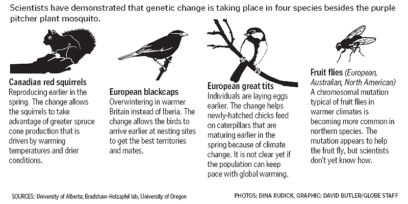
This news can fit into curricula in several ways, in several courses: Insects have already evolved in response to climate shifts due to global warming.
A mosquito that can barely fly is one of only five known species that scientists say have already evolved because of global warming. The unobtrusive mosquito’s story illustrates a sobering consequence of climate change: The species best suited to adapting may not be the ones people want to survive.
Such news enhances biology studies of genetics and insects, geography studies of climate, animal dispersal patterns and disease and pest ranges (a subject more technically known as biogeography), and the articles lend urgency to studies of how governments react to natural crises, a topic suitable for government classes, economics, and U.S. and world history.
It’s almost over for this year, but the lesson plans at the site for National Environmental Education Week don’t have to be done in April only. Texas will have a new beefed up science requirement kick in, in a couple of years. Until then, however, this is a good set of ideas, even for social studies, especially if no other class is delivering the material well.
Environmental protection weaves science — biology, chemistry, geology, meteorology, and more — with applied social studies, especially history, economics and government, to make changes. For younger students studies of recycling can be a lot of fun and give students something to take with them for the rest of the life. Similarly, a study of migratory birds and the policy issues related to them (tall buildings, cellular communications towers, oil well sumps, lights in cities, hunting and the Treaty of 1948, etc., etc.) offers a lot of ways to get kids interested, if not excited, about these so-called dry topics. An advanced class in high school might analyze the Supreme Court decisions that brought down the price of shipping of recycled metals, making recycling economically feasible.
We have a couple of sterling contributions for the next Fiesta de Tejas!
More. We should have more submissions. Texas is a big state, with a lot of people, and a lot of entertaining history. We need more entries. Deadline for entries is end of day April 30, 2007 — I’m looking to publish on May 2.
Fiesta de Tejas! is a blog carnival celebrating Texas, Texas history and Texana. This blog focuses on education and social studies (though the focus wanders a bit sometimes). If you wonder whether a particular post might be useful to the Fiesta de Tejas!, simply ask whether you think more Texans ought to know about, especially Texas social studies teachers.
“Water seeks its own level,” I explained. “Rivers carry waters to the oceans.”
He was really confused. Puzzling over Canada especially, he was venting. I was stupid, and not getting his question. “How come rivers don’t flow north?” he asked. Read the rest of this entry »
Spread the word; friends don't allow friends to repeat history.
Be careful not to unnecessarily scare students — but do point out that the world is full of danger, and natural and man-made disasters continue to plague mankind the world over.
Spread the word; friends don't allow friends to repeat history.
Or, until that account is unsuspended by the forces supporting Donald Trump: Follow @FillmoreWhite, the account of the Millard Fillmore White House Library
We've been soaking in the Bathtub for several months, long enough that some of the links we've used have gone to the Great Internet in the Sky.
If you find a dead link, please leave a comment to that post, and tell us what link has expired.
Thanks!
Retired teacher of law, economics, history, AP government, psychology and science. Former speechwriter, press guy and legislative aide in U.S. Senate. Former Department of Education. Former airline real estate, telecom towers, Big 6 (that old!) consultant. Lab and field research in air pollution control.
My blog, Millard Fillmore's Bathtub, is a continuing experiment to test how to use blogs to improve and speed up learning processes for students, perhaps by making some of the courses actually interesting. It is a blog for teachers, to see if we can use blogs. It is for people interested in social studies and social studies education, to see if we can learn to get it right. It's a blog for science fans, to promote good science and good science policy. It's a blog for people interested in good government and how to achieve it.
BS in Mass Communication, University of Utah
Graduate study in Rhetoric and Speech Communication, University of Arizona
JD from the National Law Center, George Washington University


 Posted by Ed Darrell


