It’s difficult to get a picture of what the United Kingdom really looks like. Imaginations and assumptions can distort decisions that affect our lives. We often hear the idea that there is simply no more room in the country. In reality, just six per cent of the UK is built on.
‘The UK in 100 Seconds’ is a provocative and thought provoking film that rearranges the United Kingdom’s land into 32 categories and divides them over 100 seconds. Each second equates to 1% of what the country looks like from the air.
Made by guerrilla geographer Daniel Raven-Ellison and filmmaker Jack Smith, the film was made by travelling from Tongue in the north of Scotland to the New Forest in the south of England. Each second of the film covers roughly one metre of Raven-Ellison’s walk through moorland and peat bogs, down a runway and over a dump.
Made in collaboration with Friends of the Earth, the film gives an honest reflection of what land looks like and how it is used in the United Kingdom and raises some challenging questions. A major inspiration for Raven-Ellison making the film is the amount of space that is used for feeding livestock and the question – what if we made more space for nature?
Spread the word; friends don't allow friends to repeat history.
During the RARE II Wilderness Assessment process, and during the Sagebrush Rebellion of the 1970s and 1980s, wildcatters along the Rocky Mountains spine of the west would say we couldn’t rule out any area as having no oil unless we drilled first.
But no one’s found oil in Timpanogos.
Instead, we’ve found Timpanogos in oil.
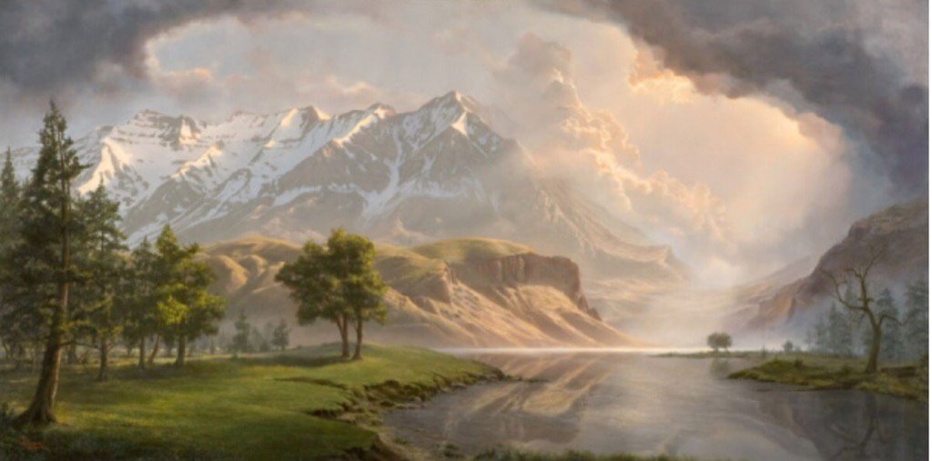
Mt. Timpanogos Millennium, by Adam Abram (b. 1976). From Tweet by Don Ruggles (@DHRuggles) and @TeresaVeiga1
It’s an interesting view of the mountain, from the southwest. At the right of the picture is Provo Canyon. The body of water must be the Provo River, but in a serene state I think could not have existed at any time. The bluffs shown past the juniper trees are unfamiliar to me. I’m guessing the artist, Adam Abram, has idealized Timpanogos as the Mormon pioneers might have found it. The area portrayed is probably part of Orem, Utah, today — covered by housing tracts and power lines.
Anyone know? A topological map covering the mouth of Provo Canyon to where the river enters Utah Lake might offer much more specific information. I don’t have one of those at the moment.
Compare it with this photo of Timpanogos (in late summer) by Bob Walker of Orem, 2012:
Utah’s Mount Timpanogos looking Northeast; Provo Canyon to the left of the photo. Photo by Bob Walker.
I grew up in the shadow of beautiful Mt. Timpanogos. This mountain, towering over Utah Valley, stands at 11,749 feet above sea level and once rose above the shores of ancient Lake Bonneville. Its name is a Paiute word meaning “river of rock.” My goal as an artist was to memorialize my favorite mountain with a 19th century style similar to the Hudson River School. In the process of creation, I did studies of several trees from around the mountain and painted them in. Sadly, those trees have been torn down with the growth of business and home development. This painting is a tribute to the beauty and majesty of this incredible mountain. This painting won 3rd place in the prestigious 2007 International ARC salon.
I’m not alone in loving that mountain. Who knew?
Spread the word; friends don't allow friends to repeat history.
Wisdom is a 64-year old albatross who remarkably returns to the Midway National Wildlife Refuge every year, and has raised chicks most of those years. Midway NWR is northwest of Hawaii:
“Conservatives” want to sell these lands off, or drill for oil or gas, or mine for minerals, on many of these lands. Will these places be preserved for your great grandchildren and America’s future?
Spread the word; friends don't allow friends to repeat history.
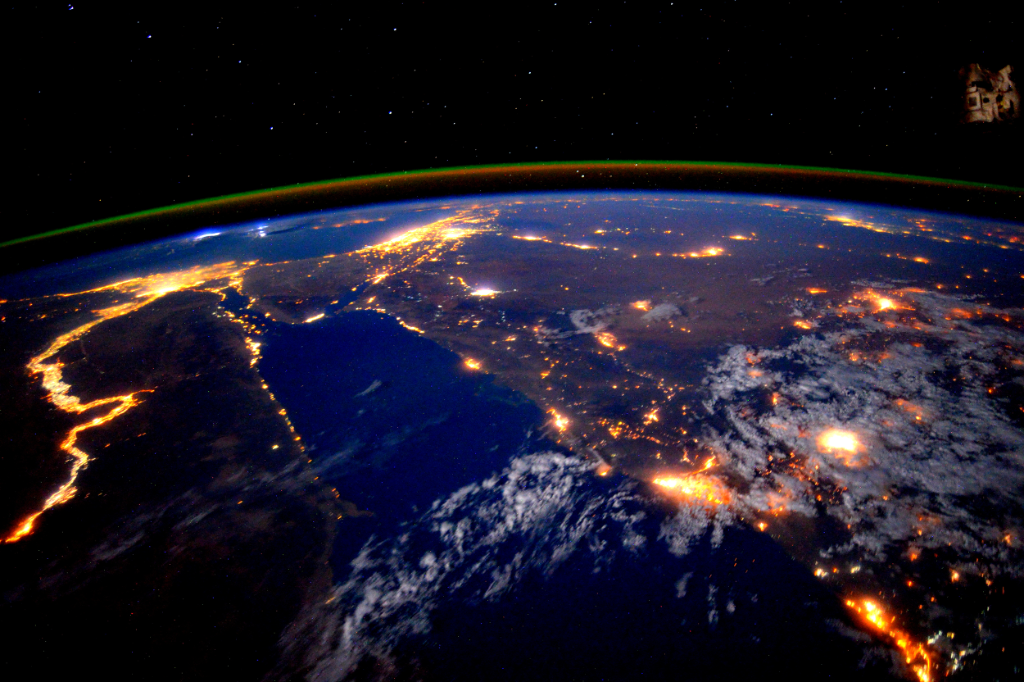
Geography teachers love the Nile Delta because it so well epitomizes what a river delta is — clear demonstration of the delta form, in real photos.
From the International Space Station, the model gets ramped up a bit:
Twitter caption: A stunning pic taken by @StationCDRKelly while on @Space_Station shows the Nile River at night http://go.nasa.gov/1iAE3EV
The Nile becomes a river of light, showing the advance of electrified human settlement along the banks, and providing stark contrast to the unlighted desert on either side of the river.
What other cities, landmarks, or geographical features can you identify in the photo?
Spread the word; friends don't allow friends to repeat history.
National Geographic Society reminded us they’ve had to change maps of the arctic.
National Geographic Society composed this GIF to compare their maps over past 16 years: A GIF of National Geographic atlases from 1999 through 2014 shows how Arctic ice has melted over time.
Ice loss is accelerated in the Arctic because of a phenomenon known as the feedback loop: Thin ice is less reflective than thick ice, allowing more sunlight to be absorbed by the ocean, which in turn weakens the ice and warms the ocean even more, NASA says.
“You hear reports all the time in the media about this,” Valdés said. “Until you have a hard-copy map in your hand, the message doesn’t really hit home.”
At the last edition of the National Geographic Atlas, a video described why and how changes were made.
We used to think the old Earth was so massive, little could humans do to change it. While it’s probably still true the rock will survive after humans are extinct, we now know we can foul our nest enough to make it uncomfortable, or impossible for our species to stay here.
Global warming is changing the planet. Maps must be changed to show the new face.
Have we acted soon enough, and hard enough to save space for humans to live?
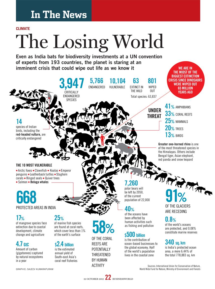
Even as India bats for biodiversity investments at a UN convention of experts from 193 countries, the planet is staring at an imminent crisis that could wipe out life as we know it.
This would be a good poster for geography, biology, general science and world history courses. Can your drafting class print this out for you in poster format?
When all of the “coal mine canaries” on Earth die out, how much longer have humans left to live on Earth?
ven as India bats for biodiversity investments at a UN convention of experts from 193 countries, the planet is staring at an imminent crisis that could wipe out life as we know it.Compiled by Yashodhara Dasgupta
ven as India bats for biodiversity investments at a UN convention of experts from 193 countries, the planet is staring at an imminent crisis that could wipe out life as we know it.Compiled by Yashodhara Dasgupta
Poster from BioMed Central for World Malaria Day 2014
Time for a big push to smash the disease’s hold on humanity, maybe eradicate it. Are you in?
No, DDT is not the answer, not even much of AN answer.
How can you help, right now?
Send $10 to Nothing But Nets. Bednets are dramatically more effective than just insecticides, in preventing malaria infections and saving lives. Your $10 donation will save at least one life.
Write to your Congressional delegation, and urge them to increase funding to the President’s Malaria Initiative. Malaria does well when people in non-malaria regions turn their backs on the problem. Malaria declines with constant attention to nation-wide and continent-wide programs to prevent the disease, by diminishing habitat for mosquitoes, curing the disease in humans so mosquitoes have no well of disease to draw from, and preventing mosquitoes from biting humans, with window screens, education on when to stay indoors, and bednets.
Last time the SBOE approved social studies books in 2010, the process was contentious. This photo, from The Christian Science Monitor, shows protests on the books; photo by Larry Kolvoord, Austin American-Statesman
Good news a few days ago was that the Texas State Board of Education approved science books that teach real science, for use in Texas schools.
But the Road Goes On Forever, and the Tea Party Never Ends: Social studies books are up for review, now.
TEA is looking for nominations for reviewers for books in social studies, math and fine arts. Here’s the notice I got in e-mail:
The Texas Education Agency is now accepting nominations to the state review panels that will evaluate instructional materials submitted for adoption under Proclamation 2015.
Proclamation 2015 calls for instructional materials in the following areas:
♦ Social Studies, grades K-12
♦ Social Studies (Spanish), grades K-5
♦ Mathematics, grades 9-12
♦ Fine Arts, grades K-12
State review panels are scheduled to convene in Austin for one week during the summer of 2014 to review materials submitted under Proclamation 2015. The TEA will reserve hotel lodging and reimburse panel members for all travel expenses, as allowable by law.
Panel members should plan to remain on-site for five days to conduct the evaluation.
Panel members will be asked to complete an initial review of instructional materials prior to the in-person review.
Panel members will receive orientation and training both prior to the initial review and at the beginning of the in-person review.
Panel members might be asked to review additional content following the in-person review.
Because many of the samples will be delivered electronically, panel members should be comfortable reviewing materials on-screen rather than in print.
Panel members should also have a working knowledge of Microsoft Excel.
Upon initial contact by a representative of the TEA, state review panel nominees begin a “no-contact” period in which they may not have either direct or indirect contact with any publisher or other person having an interest in the content of instructional materials under evaluation by the panel. The “no contact” period begins with the initial communication from the Texas Education Agency and ends after the State Board of Education (SBOE) adopts the instructional materials. The SBOE is scheduled to adopt Proclamation 2015 materials at its November 2014 meeting.
Photo and caption from Milwaukee Journal-Sentinel: Does Lake Michigan’s record low mark beginning of new era for Great Lakes? At least 150 years of rhythmic pulses in Lake Michigan’s water levels appear to have shifted abruptly with loss of winter ice. Photo by Mark Hoffman, Milwaukee Journal-Sentinel
Don’t get complacent, yet. Has enough water fallen in the Great Lakes drainage area in the past six months to change this situation at all? From the New York Times last June:
Water levels in the Great Lakes have been below their long-term averages during the past 14 years, and this winter the water in Lakes Michigan and Huron, the hardest-hit lakes, dropped to record lows, according to the Army Corps of Engineers. Keith Kompoltowicz, the chief of watershed hydrology with the corps’s Detroit district, said that in January “the monthly mean was the lowest ever recorded, going back to 1918.”
While spring rains have helped so far this year, levels in all five Great Lakes are still low by historical standards, so getting through the shallow points in harbors and channels is a tense affair.
It’s not just storms, rising sea levels, and melting glaciers, you know.
The Great Lakes from space. The Great Lakes are the largest glacial lakes in the world. NASA photo via Wikipedia
See this United Nations Development Program ten-minute video that, to the wise and concerned, lays out the stakes of delaying action against human-caused climate change.
Without enough funding, NGOs work to help farmers getting hammered in the Southern Philippines, and other places.
In the Southern Philippines, farmers’ lives and the weather are intimately interwoven, but something is changing, now that the rains in Agusan del Norte are too heavy, the sun shines too fiercely. Now there’s hope for poor farmers with the community-based approach monitoring and Weather Index-Based Insurance packages, to warn people when heavy weather is on the way.
Though, I do weary of the astonishing abuse of acronyms in this work-of-the-angels. “WIBI?”
Incidentally, though the phrase doesn’t appear anywhere in this material, this is exactly the sort of work carried on by the UN’s Agenda 21 project. Doesn’t look subversive to me.
Tip of the old scrub brush to the UNDP and ILO Tweet:
Contrary to popular rural and redneck legend, Caddo Lake is not Texas’s only natural* lake. There’s also Big Lake, near the town of Big Lake.
Problem being, of course, that Big Lake’s water sources these days generally don’t flow. So Big Lake is often dry.
Which produces a further problem for site like Millard Fillmore’s Bathtub: If Big Lake is really a lake, why are there no photos of the lake with water in it?
A comment at AustinBassFishing.com got me thinking about this again, no photos of Big Lake as a Lake. In the previous post here, we featured a photo of Big Lake Playa, sans water. I searched the internet at the time and found no photos showing water in the lake. My authority on Big Lake, Brad Wachsmann, swore that he had recently seen water in the thing (“recent” being “in the last decade or so”).
So, sorta good news: A few photos of Big Lake, with water, plopped onto the internet since our last search. Here are a couple from Panaramio:
Water in Big Lake, near the city of Big Lake, Texas, laps at the State Highway 137 passing nearby. This photo comes from 2004, by doning.
Photo of water in Big Lake from June 2005. Photo by evansjohnc. This photo appears to be about midway along the intersection of the lake with State Highway 137.
Big Lake in its dry phase, from looking north from the southern end of State Highway 137’s transection of the lake. Photo by cwoods.
Non-historic marker for Big Lake, also along State Highway 137, looking west. Photo by cwoods. Photo taken during Big Lake’s dry humor phase.
And, Dear Reader, can you find good photos of Big Lake with, you know, water in it?
_____________
* Is Caddo Lake a natural lake? Originally, the lake seems to have been formed by an enormous blowdown of trees, probably during a hurricane, well over 400 years ago. In that sense, it was a natural lake when European explorers first found it, and during all of Texas’s “six flags” historic periods. Or, what is known as the Great Raft, a log jam, dammed up the Red River near the confluence of the Big Cypress Bayou, in about 1799. By 1800, Caddo Lake was wet all year-round, and deep enough for shallow boat navigation. In 1835, Capt. Henry Shreve blew up enough of the logjam that steamboat traffic could get past (the guy after whom Shreveport, Louisiana, is named). After the Civil War, locals tried to expand boat traffic by completely removing the logjam. Instead of making traffic easier, this removal led shrinking water levels in the lake, and it destroyed navigation farther up the Red River. Several efforts to restore higher water levels achieved some success by about 1915. When oil was discovered under the swamp, pressures came from oil companies to make drilling easier — travel in the mud was difficult. After the invention of the Hughes drill bit (by Howard Hughes‘s father, the founder of Hughes Tool Co.) to allow drilling through water and mud into oil-bearing rock, a dam was built near where the logjam had been, to raise the level of what is known today as Caddo Lake. What is seen today is a human-enhanced version of the Caddo Lake known by the Caddo Tribe. This is all preface to the current Texas water wars.
Lincoln’s (and Darwin’s) birthday rolls around again next week. What do we know about our 16th president who was the subject of a great and a silly movie in the last year?
Some wag sent out this Tweet today.
But Lincoln also taught himself geometry just to better himself. He is only POTUS who held a patent.
Any visitor to Thomas Jefferson’s home at Monticello knows of Jefferson’s wide-ranging interests, and work in science and invention. I was rather surprised to discover the depth of George Washington’s inventive work, in a seminar sponsorred by the Bill of Rights Institute at Mount Vernon a few years ago.
Abraham Lincoln, too?
Sangamon River near Lincoln’s first home in Illinois – Photo from Wikipedia
Lincoln lived along the Sangamon River, and he saw development of the river for commercial navigation to be a boon for his district’s economic growth. Unfortunately, the Sangamon is not deep; boats had difficult times navigating over the many logs and snags, and shallows.
So, Mr. Lincoln offered a technical solution, for which he was granted a patent in 1849. Details below, from Google Patents:
Drawing for Abraham Lincoln’s patent of a boat bouying apparatus.
Was Lincoln the only president to get a patent? Thomas Jefferson and George Washington worked hard at inventions. Jefferson shared Ben Franklin’s view that new inventions should be for the benefit of all; does that mean he didn’t seek patents? Washington’s inventions — including the 16-sided barn for threshing wheat — tended to be improvements on processes; I don’t know of any evidence he even thought of patenting any idea.
It’s possible that Lincoln was the only president so far to have held a patent.
Lincoln’s invention was never built, and that patent never used.
You wondered how anyone could ever fall in love with the modern megalopolis that is Los Angeles?
Along comes Colin Rich with this video ode, visual poetry to an essential chunk of America. Oh, yeah, it’s got lots of time-lapse. Notice how the photography turns simple airplanes into something akin to shooting stars, and notice how even an ugly old radio tower crowded with microwave and digital communication antennae turn into things of grace, if not beauty:
A big thanks to Matthews MSE (msegrip.com) especially to Bob Kulesh, Tyler & Ed Phillips for their generous support and patience of this lengthy endeavor. Most of the linear motion control shots were captured using their FloatCam DC Slider, a wonderful piece of engineering for the time lapse world.
‘Nightfall’ is a three minute tour of light through the City of Angels.
I shot “Nightfall” in an attempt to capture Los Angeles as it transitioned from day to night. As you probably know, LA is an expansive city so shooting it from many different angles was critical. Usually I was able to capture just one shot per day with a lot of driving, exploring, and scouting in between but the times sitting in traffic or a “sketchy” neighborhood often lead to new adventures and interesting places.
Nightfall in particular is my favorite time to shoot time lapse. Capturing the transition from day to night while looking back at the city as the purple shadow of Earth envelopes the eastern skyline and the warm distant twinkling halogen lights spark to life and give the fading sun a run for her money- this will never grow old or boring to me.
In this piece, it was important to me for the shots to both capture and accentuate the movement of light through the day and night and the use of multiple motion control techniques allowed me to do so.
I hope you enjoy watching it as much as I enjoyed creating it.
An English translation of the lyrics-
“It is late. I am looking for my other home, taking an unfamiliar path: a small trail near the factories and the city, cutting through the forest. I can barely see nature when suddenly, night falls. I am engulfed by a world of silence, yet I am not afraid. I fall asleep for a few minutes at the most, and when I wake up, the sun is there and the forest is shining with a bright light.
I recognize this forest. It is not an ordinary forest, it is a forest of memories. My memories. The white and noisy river, my adolescence. The tall trees, the men I have loved. The birds in flight, and in the distance, my lost father.
My memories aren’t memories anymore. They are there, with me, dancing and embracing, singing and smiling at me.
I look at my hands. I caress my face, and I am 20 years old. And I love like I have never loved before.”
Surely this film can be used, at least for a bell ringer or warmup, in geography classes.
Spread the word; friends don't allow friends to repeat history.
This year’s Geography Awareness Week theme is Declare Your Interdependence! Geographers around the nation will celebrate our interconnectedness November 11-17, 2012!
To celebrate, TAGE is sponsoring the 25th Annual Poster Contest
How are you connected to the rest of the globe on a daily basis? What images demonstrate interdependence for you? This year’s posters should illustrate different forms and examples of interdependence. Focus on the physical and cultural processes that keep you connected around the globe, and how this shapes your daily life.
More information on the Poster Contest, including rules, registration, and resources at http://www.geo.txstate.edu/tage/geography-awareness-week.html
Poster Contest Registration: Deadline October 19; Posters due to the TAGE office by October 25
Please contact us if you have any questions, and feel free to share with us new resources or ideas that you may have. We will continue to add resources and links as we find them to help you demonstrate interdependence to your classroom.
Let’s make this the best poster contest yet!
Maggie Hutchins
—
Texas Alliance for Geographic Education
Department of Geography
Texas State University
601 University Drive
San Marcos, TX 78666 http://www.geo.txstate.edu/tage/
phone: (512) 245-3827
fax: (512) 245-1653
Little towns in Kansas look like neutron bomb test sites. Especially on a Saturday afternoon, there are no people. Many of the buildings look as though they haven’t been occupied since Dwight Eisenhower was president.
But there’s a cafe in Scott, Kansas, about the intersection of U.S 40 and U.S. 83, that looks like a new business in an old building, the Road Kill Grill. It’s motto:
“Road Kill Grill: For diners with discerning tastes.”
Or, until that account is unsuspended by the forces supporting Donald Trump: Follow @FillmoreWhite, the account of the Millard Fillmore White House Library
We've been soaking in the Bathtub for several months, long enough that some of the links we've used have gone to the Great Internet in the Sky.
If you find a dead link, please leave a comment to that post, and tell us what link has expired.
Thanks!
Retired teacher of law, economics, history, AP government, psychology and science. Former speechwriter, press guy and legislative aide in U.S. Senate. Former Department of Education. Former airline real estate, telecom towers, Big 6 (that old!) consultant. Lab and field research in air pollution control.
My blog, Millard Fillmore's Bathtub, is a continuing experiment to test how to use blogs to improve and speed up learning processes for students, perhaps by making some of the courses actually interesting. It is a blog for teachers, to see if we can use blogs. It is for people interested in social studies and social studies education, to see if we can learn to get it right. It's a blog for science fans, to promote good science and good science policy. It's a blog for people interested in good government and how to achieve it.
BS in Mass Communication, University of Utah
Graduate study in Rhetoric and Speech Communication, University of Arizona
JD from the National Law Center, George Washington University


 Posted by Ed Darrell