Europe, mapped by famous art works

September 26, 2018

This is stunning, politically hot, and frustrating in that I cannot immediately identify the artworks (I think one is a sculpture photograph), let alone the artists.

But still cool.

Who made it? Where is the legend to identify the art?

From Simon Kuestenmacher (on Twitter: @simongerman600):

From Simon Kuestenmacher (on Twitter: @simongerman600): “Map of Europe with each country represented by one of it’s most recognizable pieces of art. How many can you name? Source: https://buff.ly/2eKIYUV”

Mr. Kuestenmacher found the map on Reddit. Ripred42, who posted it on Reddit, didn’t offer any other details as to who made the map or what the art works are; several comments identify several of the works. I have not yet found a better legend.

This map might make a good exercise for AP Geography or AP Human Geography, or AP History, or IB History. There are some possibilities for good discussion. At Reddit there is a complaint that the Mona Lisa shouldn’t represent Italy, since it was sold to a foreign king and is displayed in a foreign museum. The Gustav Klimt painting shown for Austria was determined to have been stolen from its rightful owners, who took the painting and put it on display in New York City instead (the subject of the movie starring Helen Mirren, “The Woman in Gold.”)

Is Turner really the best representative for England? Can any work be determined for Cypress or Ireland? The discussion on Twitter is better than Reddit, and most informative.

Can you identify the works? I’ll list those I can figure out in comments. Please help identify others if you can.

Tip of the old scrub brush to Simon Kuestenmacher on Twitter.


Typewriter of the moment: Milan Karanovic, Bosnian ethnographer

February 22, 2017

Ethnographer? It’s a person who makes a systematic study of a people and its culture, a subdivision of anthropology, sociology, history and geography all at once.

Milan Karanovic, trained as a priest, studied folk and cultural trends of Bosnians, roughly from 1900 to World War II.

And this is his typewriter:

Typewriter of Bosnian ethnographer Milan Karanovic. Take careful note of special keys to accommodate Bosnian spellings. Typewriter on display in the National Museum of Bosnia and Herzegovina. Photo courtesy of Jonathan Halabi.

Typewriter of Bosnian ethnographer Milan Karanovic. Take careful note of special keys to accommodate Bosnian spellings. Typewriter on display in the National Museum of Bosnia and Herzegovina. Photo courtesy of Jonathan Halabi.

Photo of Milan Karanovich, National Museum of Bosnia and Herzegovina. "Zivot i rad" translates to "life and work." Image by Jonathan Halabi.

Photo of Milan Karanovich, National Museum of Bosnia and Herzegovina. “Zivot i rad” translates to “life and work.” Image by Jonathan Halabi.

Milan Karanovic was born in 1883 in Great Novljansko Rujiška. In his teens he moved to Sarajevo, graduated high school and attended seminary, graduating by 1909 and assuming duties as a parish priest (Orthodox?) in the Krajina region village of Rujnić. We know he published a study of the “village” of Sarajevo in 1907. On the wrong side of local authorities in World War I, he spent much of the war in prison. His publications resumed by 1925, and proliferated through 1937. He died in 1955.

The typewriter is an Optima Elite. I’m guessing this model was made during or after World War II; Optima used the Olympia name into World War II. After the war, Olympia factories in the zones controlled by the Soviet Union changed to Optima. Judging from photos, this machine may have been built in the 1950s, giving Karanovic only a few years to use it. I’m open to the idea that the Optima name was used earlier — this history of corporations and machines is out of my range. If you have better information, please feel free to contribute in comments.


58 years ago, January 3, 1959: Welcome, Alaska, and the 49-star flag

January 3, 2017

Alaska Territorial Gov. Bob Bartlett in center, with the 49-star flag (Bartlett was one of Alaska's first U.S. senators).

Alaska Territorial Gov. Bob Bartlett in center, with the 49-star flag (Bartlett was one of Alaska’s first U.S. senators).

The great service at the New York Times site, the Learning Network, notes the 1959 Dwight Eisenhower proclamation of Alaska as the 49th state, and the unveiling of the 49-star flag:

On Jan. 3, 1959, President Dwight Eisenhower signed a proclamation admitting Alaska to the Union as the 49th state. The New York Times noted that the signing included the unveiling of the new 49-star American flag.

The land that became Alaska came into U.S. possession in 1867, when William Seward, secretary of state under President Andrew Johnson, negotiated a deal to buy the 586,000-square-mile area from Russia for $7.2 million, less than 2 cents per acre. Seward’s decision was ridiculed in the American press, who saw no potential in the vast, inhospitable and sparsely populated area.

For decades after its purchase, Alaska was derided as “Seward’s folly” or “Seward’s icebox.” This opinion changed in 1896 with the discovery of gold in the neighboring Yukon Territory, which spurred tens of thousands of people to head to Alaska in search of gold. The gold rush also brought about a boom in mining, fishing and trapping.

Though the first statehood bill had been presented to Congress in 1916, there was little desire in either Alaska or Washington for Alaskan statehood until after World War II. During the war, the U.S. established multiple military bases to resist Japan’s attacks on Alaska’s Aleutian Islands and prevent a potential invasion of the mainland. The military activity, along with the completion of a major highway from Montana, led to a large population growth.

In 1946, Alaskans voted in favor of statehood in a referendum and Alaskan delegates began to lobby Congress for statehood. After years of debate, Congress voted in June 1958 to admit Alaska.

Eight months after Alaska’s admission, on Aug. 21, 1957 [should be 1959, no?], Hawaii became the 50th state. The 49-star remained in place until the following July 4, when it was replaced by the now-familiar 50-star flag.

49-star flags were produced only until August 1959, so there are few of them around.  I love this photo of the unveiling of the flag with President Eisenhower:

President Eisenhower and Quartermaster General MG Andrew T. McNamara, with 49-star flag - image from QM foundation

“Quartermaster General MG Andrew T. McNamara and President Eisenhower examine new 49 star flag” – image and caption from the Quartermaster Foundation. Photo by Bob Schutz, Associated Press (Who are the other two people?  The guy on the right looks to me a bit like is Pennsylvania’s Sen. Hugh Scott.)

It had been about 47 years since the previous state admission (Arizona); people became aware that no law set what the flag should look like.  President Eisenhower issued a directive.

How did the nation survive for 170 years without firm, decisive and conclusive orders on what the U.S. flag should look like?  Isn’t it a great story that we went so long without law setting the requirements?

Alaska's state flag design came from 13-year old Benny Benson.

Alaska’s state flag design came from 13-year old Benny Benson. Benny Benson holding the Alaska flag at the Jesse Lee Home, Seward, Alaska. ASL-P01-1921, Alaska State Library-Historical Collections.


Alaska’s state flag came from the imagination of a 13-year-old Aleut, Benny Benson, winning a contest to design the state’s flag.  Alaska’s flag stands out in any display of U.S. state flags.

Alaska's flag as it was approved by the state legislature, and still flies today. Image from the Ninilchik Natives Association, Inc (NNAI).

Alaska’s flag as it was approved by the state legislature, and still flies today. Image from the Ninilchik Natives Association, Inc (NNAI).


Yes, this is mostly an encore post. Fighting ignorance requires patience.

Yes, this is mostly an encore post. Fighting ignorance requires patience.

Save

Save

Save

Save

Save


August 21, 2016: Fly your flag for Hawaii Statehood in 1959

August 21, 2016

It’s been 57 years since the youngest state entered the union — the longest stretch in which the U.S. has not added another state.

"On June 14, 1959, Boy Scout Milton Motooka helped get the word out for Hawaii’s statehood plebiscite to be held 13 days later. A new documentary will focus on Hawaii’s statehood." Hawaiians voted yes in the plebiscite, and statehood was declared two months later. (Whatever became of Scout Motooka?)

“On June 14, 1959, Boy Scout Milton Motooka helped get the word out for Hawaii’s statehood plebiscite to be held 13 days later. A new documentary will focus on Hawaii’s statehood.” Hawaiians voted yes in the plebiscite, and statehood was declared two months later. (Whatever became of Scout Motooka? See comments on last year’s post.)

“On June 14, 1959, Boy Scout Milton Motooka helped get the word out for Hawaii’s statehood plebiscite to be held 13 days later. A new documentary will focus on Hawaii’s statehood.” Hawaiians voted yes in the plebiscite, and statehood was declared two months later. (Whatever became of Scout Motooka?)

June’s plebiscite smoothed the path for statehood, declared two months later.

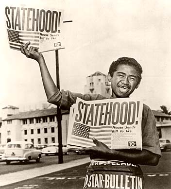
A newsboy happily hawks the Honolulu Star-Bulletin with the headline showing the state had achieved statehood, August 21, 1959. Star-Bulletin photo

13-year-old paperboy Chester Kahapea happily hawks a commemorative edition of the Honolulu Star-Bulletin with the headline showing the state had achieved statehood after the U.S. House of Representatives passed the law authorizing Hawaii as a state. Star-Bulletin photo by Murray Befeler.

Hawaii’s official statehood day is August 21, commemorating the day in 1959 when Hawaii was recognized as a member of the union of the United States of America.  Hawaiians should fly their flags to day in honor of the date (you may, too).

Hawaii formally celebrates the day on the third Friday in August, this year on the 19th.  I hope you joined in the festivities (it’s a holiday in Hawaii) — but under the U.S. Flag Code, you may certainly fly your flags on August 21, regardless which day of the week that is.

Specimen copy of the ballot used by Hawaiians in a June 27, 1959, plebiscite to approve conditions of statehood. Image from Hawaii Magazine, 2009

Specimen copy of the ballot used by Hawaiians in a June 27, 1959, plebiscite to approve conditions of statehood. Image from Hawaii Magazine, 2009

After the U.S. annexed Hawaii in 1898 (in action separate from the Spanish-American War) attempts at getting Hawaii admitted as a state got rolling.  After World War II, with the strategic importance of the islands firmly implanted in Americans’ minds, the project picked up some steam.  Still, it was 14 years after the end of the war that agreements were worked out between the people of Hawaii, the Hawaiian royal family, Congress and the executive branch.  The deal passed into law had to be ratified by a plebiscite among Hawaiian citizens.  The proposition won approval with 94% of votes in favor.

Some native Hawaiian opposition to statehood arose later, and deference to those complaints has muted statehood celebrations in the 21st century.

Other than the tiny handful of loudmouth birthers, most Americans today are happy to have Hawaii as a state, the fifth richest in the U.S. by personal income.  The nation has a lot of good and great beaches, but the idea of catching sun and surf in Hawaii on vacation might be considered an idealized part of the American dream.

“Loudmouth birthers?” Yeah, Barack Obama, our 45th President, was born in Hawaii in 1961. Some whiners think that, but for statehood, Obama would not have been a citizen eligible to be president. Hawaii is not good ground for growing sour grapes, though. Birth in a territory would probably be enough to make him eligible. Water under the bridge: Hawaii was a state in 1961. President Obama remains president.

U.S. and Hawaii flags flying together.

U.S. and Hawaii flags flying together.

More:

U.S. postage stamp issued in 2009 commemorating the 50th anniversary of Hawaii's admission to the union.

U.S. postage stamp issued in 2009 commemorating the 50th anniversary of Hawaii’s admission to the union.

Contrast the first class postage price above with the airmail postage price of this stamp issued in 1959 — August 21, 1959 7¢ Rose Hawaii Statehood C55 26432. Wikipedia image

Contrast the first class postage price above with the airmail postage price of this stamp issued in 1959 — August 21, 1959 7¢ Rose Hawaii Statehood stamp. Wikipedia image

This is an encore post.

This is an encore post.

Save

Save


Angry Texas mom backs down social studies text publisher, frustrates Texas School Board’s bias

October 3, 2015

Cover of the Texas edition of McGraw-Hill's World Geography (image from Birdville ISD site)

Cover of the Texas edition of McGraw-Hill’s World Geography (image from Birdville ISD site)

Oh, the power of one angry mother!

It’s not like we weren’t warned, by people like the Texas Freedom Network. The last round of “book approvals” by the Texas State Board of Education introduced some stunning inaccuracies into books used in Texas history, geography and economics classrooms. GOP appointees and board members worked hard to make sure even correct history standards could be skewed in actual texts.

One Houston-area mother saw her son’s text for world geography, videoed the thing and put it up on Facebook. Surprisingly, the publisher, McGraw-Hill, backed down, and promised fixes.

Here’s the video, from Rusty Styles:

The good news? This one angry mom got McGraw-Hill to take the ethical path, and promise to fix the caption. On Facebook again, McGraw-Hill said:

This week, we became aware of a concern regarding a caption reference to slavery on a map in one of our world geography programs. This program addresses slavery in the world in several lessons and meets the learning objectives of the course. However, we conducted a close review of the content and agree that our language in that caption did not adequately convey that Africans were both forced into migration and to labor against their will as slaves.

We believe we can do better. To communicate these facts more clearly, we will update this caption to describe the arrival of African slaves in the U.S. as a forced migration and emphasize that their work was done as slave labor. These changes will be reflected in the digital version of the program immediately and will be included in the program’s next print run.

McGraw-Hill Education is committed to developing the highest quality educational materials and upholding the academic integrity of our products. We value the insight the public brings to discussions of our content.

World geography was usually taught in the 9th grade in Texas; recent changes in requirements pushed world geography to a lesser status; many Texas kids get to pick between world geography and world history (both used to be required).

Students are old enough to need to know the truth on these issues. That is not to say that history books should stretch or chop the truth at any time, but it is to note that students in early high school are developing an ethical outlook on their lives. Adults, including book publishers, need to lead exemplary lives.

What other errors didn’t get the public scrutiny they deserved a few years ago?

Any other angry moms out there?


More:

And:


Fly your flag August 21, for Hawaii Statehood in 1959

August 21, 2015

"On June 14, 1959, Boy Scout Milton Motooka helped get the word out for Hawaii’s statehood plebiscite to be held 13 days later. A new documentary will focus on Hawaii’s statehood." Hawaiians voted yes in the plebiscite, and statehood was declared two months later. (Whatever became of Scout Motooka?)

It’s been 56 years since the youngest state entered the union — the longest stretch in which the U.S. has not added another state.

"On June 14, 1959, Boy Scout Milton Motooka helped get the word out for Hawaii’s statehood plebiscite to be held 13 days later. A new documentary will focus on Hawaii’s statehood." Hawaiians voted yes in the plebiscite, and statehood was declared two months later. (Whatever became of Scout Motooka?)

“On June 14, 1959, Boy Scout Milton Motooka helped get the word out for Hawaii’s statehood plebiscite to be held 13 days later. A new documentary will focus on Hawaii’s statehood.” Hawaiians voted yes in the plebiscite, and statehood was declared two months later. (Whatever became of Scout Motooka?)

“On June 14, 1959, Boy Scout Milton Motooka helped get the word out for Hawaii’s statehood plebiscite to be held 13 days later. A new documentary will focus on Hawaii’s statehood.” Hawaiians voted yes in the plebiscite, and statehood was declared two months later. (Whatever became of Scout Motooka?)

June’s plebiscite smoothed the path for statehood, declared two months later.

A newsboy happily hawks the Honolulu Star-Bulletin with the headline showing the state had achieved statehood, August 21, 1959. Star-Bulletin photo

13-year-old paperboy Chester Kahapea happily hawks a commemorative edition of the Honolulu Star-Bulletin with the headline showing the state had achieved statehood after the U.S. House of Representatives passed the law authorizing Hawaii as a state. Star-Bulletin photo by Murray Befeler.

Hawaii’s official statehood day is August 21, commemorating the day in 1959 when Hawaii was recognized as a member of the union of the United States of America.  Hawaiians should fly their flags to day in honor of the date (you may, too).

Hawaii formally celebrates the day on the third Friday in August, this year coincidentally on the 21st.  I hope you joined in the festivities (it’s a holiday in Hawaii) — but under the U.S. Flag Code, you may certainly fly your flags on August 21, regardless which day of the week that is.

Specimen copy of the ballot used by Hawaiians in a June 27, 1959, plebiscite to approve conditions of statehood. Image from Hawaii Magazine, 2009

Specimen copy of the ballot used by Hawaiians in a June 27, 1959, plebiscite to approve conditions of statehood. Image from Hawaii Magazine, 2009

After the U.S. annexed Hawaii in 1898 (in action separate from the Spanish-American War) attempts at getting Hawaii admitted as a state got rolling.  After World War II, with the strategic importance of the islands firmly implanted in Americans’ minds, the project picked up some steam.  Still, it was 14 years after the end of the war that agreements were worked out between the people of Hawaii, the Hawaiian royal family, Congress and the executive branch.  The deal passed into law had to be ratified by a plebiscite among Hawaiian citizens.  The proposition won approval with 94% of votes in favor.

Some native Hawaiian opposition to statehood arose later, and deference to those complaints has muted statehood celebrations in the 21st century.

Other than the tiny handful of loudmouth birthers, most Americans today are happy to have Hawaii as a state, the fifth richest in the U.S. by personal income.  The nation has a lot of good and great beaches, but the idea of catching sun and surf in Hawaii on vacation might be considered an idealized part of the American dream.

U.S. and Hawaii flags flying together.

U.S. and Hawaii flags flying together.

More:

From Prologue, the blog of the National Archives: This petition, rolled onto a wooden spool, was signed by 116,000 supporters of Hawaii statehood and presented to the U.S. Senate on February 26, 1954. (RG 46, Records of the U.S. Senate)

From Prologue, the blog of the National Archives: This petition, rolled onto a wooden spool, was signed by 116,000 supporters of Hawaii statehood and presented to the U.S. Senate on February 26, 1954. (RG 46, Records of the U.S. Senate)


U.S. postage stamp issued in 2009 commemorating the 50th anniversary of Hawaii's admission to the union.

U.S. postage stamp issued in 2009 commemorating the 50th anniversary of Hawaii’s admission to the union.


Contrast the first class postage price above with the airmail postage price of this stamp issued in 1959 — August 21, 1959 7¢ Rose Hawaii Statehood C55 26432. Wikipedia image

Contrast the first class postage price above with the airmail postage price of this stamp issued in 1959 — August 21, 1959 7¢ Rose Hawaii Statehood stamp. Wikipedia image


This is an encore post.

This is an encore post.


New Appalachian Wildlife Refuge protects very rare species: Mountain Bogs National Wildlife Refuge

May 15, 2015

A 39-acre donation from The Nature Conservancy and a lot of work by the Carolina Mountain Land Conservancy joined to birth a new National Wildlife Refuge in North Carolina.

Welcome the Mountain Bogs National Wildlife Refuge.

Jack-in-the-pulpit, one of the less rare of the rare plants protected by the creation of the Mountain Bogs National Wildlife Refuge in North Carolina. USFWS photo

Jack-in-the-pulpit, one of the less rare of the rare plants protected by the creation of the Mountain Bogs National Wildlife Refuge in North Carolina. USFWS photo

The April 22, 2015, press release from USFWS:

New National Wildlife Refuge Established to Protect Some of Appalachia’s Rarest Places

April 22, 2015

Trout lily blooming at Mountain Bogs National Wildlife Refuge. Credit: Gary Peeples, USFWS.

Trout lily blooming at Mountain Bogs National Wildlife Refuge. Credit: Gary Peeples, USFWS.

Asheville, N.C. – The Mountain Bogs National Wildlife Refuge became America’s 563rd refuge today.

U.S. Fish and Wildlife Service Deputy Director Jim Kurth visited Western North Carolina to announce the establishment of a new national wildlife refuge devoted to the conservation of southern Appalachian mountain bogs, one of the rarest and most imperiled habitats in the United States.  North Carolina is home to 11 refuges; Mountain Bogs Refuge is the first one west of Charlotte.

“The establishment of Mountain Bogs National Wildlife Refuge marks a turning point in the efforts of a number of dedicated partners in preserving this unique and threatened habitat,” said Kurth. “It will provide a focal point for mountain bog conservation in the area, and highlights the importance of our National Wildlife Refuge System in preserving our nation’s spectacular biodiversity for future generations of Americans.”

“While western North Carolina has beautiful swaths of conserved public lands, mountain bogs, which are home to several endangered species, are largely unprotected,” said Mike Oetker, Deputy Regional Director for the Service’s Southeast Region.  “People have worked for decades to conserve these bogs, and creating this refuge was an opportunity to build on that effort in a significant way.”

The Nature Conservancy donated an easement on a 39-acre parcel in Ashe County, the site of Kurth’s visit, which formally establishes the refuge.

“Today’s announcement is the culmination of years of work by conservation partners at the local, state and national level,” said The Nature Conservancy’s Fred Annand, who coordinates the Conservancy’s acquisition work. “Many people have worked together for years to make today a reality. Successful conservation depends on partnership, and that’s certainly the case today.”

Mountain bogs are typically small and widely scattered across the landscape, often isolated from other wetlands. Important to wildlife and plants, mountain bogs are home to five endangered species – bog turtles, green pitcher plant, mountain sweet pitcher plant, swamp pink (a lily), and bunched arrowhead. They also provide habitat for migratory birds and game animals, including mink, woodcock, ruffed grouse, turkey, and wood duck. Bogs are breeding habitat for many species of amphibians, especially salamanders, of which the Southern Appalachians have the greatest diversity in the nation. Bogs also provide key benefits to humans. They have a natural capacity for regulating water flow, holding floodwaters like giant sponges and slowly releasing water to nearby streams decreasing the impacts of floods and droughts.

In addition to The Nature Conservancy, Carolina Mountain Land Conservancy has long been active in bog conservation and has been supportive of establishing the new refuge.

“Southern Appalachian bogs are biodiversity hotspots,” said Kieran Roe, Executive Director at Carolina Mountain Land Conservancy. “But they are disappearing from our region at a rapid rate. Less than 20 percent of the mountain bogs that once existed still remain, so their protection is critical.”

The refuge may eventually grow to 23,000 acres, depending on the willingness of landowners to sell and the availability of funds to purchase those lands. To guide acquisition, and bog conservation in general, the Service has identified 30 sites, or Conservation Partnership Areas, containing bogs and surrounding lands. These sites are scattered across Alleghany, Ashe, Avery, Clay, Graham, Henderson, Jackson, Macon, Transylvania, Wilkes and Watauga counties in North Carolina, and Carter and Johnson counties in Tennessee. The Service will look primarily within these Conservation Partnership Areas to acquire land and/or easements. For those acres that won’t be acquired, the Service will work to support private landowners in their stewardship activities. Funding to acquire land and easements would likely come from the Land and Water Conservation Fund, funded by fees collected from the sale of publicly-owned offshore oil and gas drilling leases.

While some parts of the refuge would likely be too fragile for recreation, the Service anticipates other parts could be open for wildlife-based recreation, including hunting, fishing, wildlife observation and photography, education, and interpretation.

The Service manages national wildlife refuges for the conservation of fish, wildlife and plants. In 1903 President Theodore Roosevelt created the first national wildlife refuge to protect brown pelican breeding grounds on the east coast of Florida. The Refuge System now includes 563 refuges across the nation, protecting more than 150 million acres. It’s the only system of federally-managed lands dedicated to wildlife. For more information, visit www.fws.gov/mountainbogs.

The National Wildlife Refuge System protects wildlife and wildlife habitat on more than 150 million acres of land and water from the Caribbean to the Pacific, Maine to Alaska. Refuges also improve human health, provide outdoor recreation and support local economies. Visit our home page at http://www.fws.gov/refuges. Follow us on Facebook and Twitter.

Our Dallas area trout lilies have all blossomed, weeks ago. Interesting that bog-bound trout lilies share so much in common with their drier land cousins a few thousand miles away.
More:


Coffee City? Population seems awfully low

February 6, 2015

Coffee City sign.

Coffee City, Texas

Our friend Jim Stanley posted this on Facebook.

Population count seems too low, doesn’t it?  Must be a pretty tight filter.

Caption these yourself. From the City of Coffee City website.

Caption these yourself. From the City of Coffee City website.

More:


January 3, 1959: Welcome, Alaska, and the 49-star flag — 55 years ago

January 3, 2015

Alaska Territorial Gov. Bob Bartlett in center, with the 49-star flag (Bartlett was one of Alaska's first U.S. senators).

Alaska Territorial Gov. Bob Bartlett in center, with the 49-star flag (Bartlett was one of Alaska’s first U.S. senators).

The great service at the New York Times site, the Learning Network, notes the 1959 Dwight Eisenhower proclamation of Alaska as the 49th state, and the unveiling of the 49-star flag:

On Jan. 3, 1959, President Dwight Eisenhower signed a proclamation admitting Alaska to the Union as the 49th state. The New York Times noted that the signing included the unveiling of the new 49-star American flag.

The land that became Alaska came into U.S. possession in 1867, when William Seward, secretary of state under President Andrew Johnson, negotiated a deal to buy the 586,000-square-mile area from Russia for $7.2 million, less than 2 cents per acre. Seward’s decision was ridiculed in the American press, who saw no potential in the vast, inhospitable and sparsely populated area.

For decades after its purchase, Alaska was derided as “Seward’s folly” or “Seward’s icebox.” This opinion changed in 1896 with the discovery of gold in the neighboring Yukon Territory, which spurred tens of thousands of people to head to Alaska in search of gold. The gold rush also brought about a boom in mining, fishing and trapping.

Though the first statehood bill had been presented to Congress in 1916, there was little desire in either Alaska or Washington for Alaskan statehood until after World War II. During the war, the U.S. established multiple military bases to resist Japan’s attacks on Alaska’s Aleutian Islands and prevent a potential invasion of the mainland. The military activity, along with the completion of a major highway from Montana, led to a large population growth.

In 1946, Alaskans voted in favor of statehood in a referendum and Alaskan delegates began to lobby Congress for statehood. After years of debate, Congress voted in June 1958 to admit Alaska.

Eight months after Alaska’s admission, on Aug. 21, 1957 [should be 1959, no?], Hawaii became the 50th state. The 49-star remained in place until the following July 4, when it was replaced by the now-familiar 50-star flag.

49-star flags were produced only until August 1959, so there are few of them around.  I love this photo of the unveiling of the flag with President Eisenhower:

President Eisenhower and Quartermaster General MG Andrew T. McNamara, with 49-star flag - image from QM foundation

“Quartermaster General MG Andrew T. McNamara and President Eisenhower examine new 49 star flag” – image and caption from the Quartermaster Foundation. (Who are the other two people?  The guy on the right looks to me a bit like is Pennsylvania’s Sen. Hugh Scott.)

It had been about 47 years since the previous state admission (Arizona); people became aware that no law set what the flag should look like.  President Eisenhower issued a directive.

How did the nation survive for 170 years without firm, decisive and conclusive orders on what the flag should look like?  Isn’t it a great story that we went so long without law setting the requirements?

Alaska's state flag design came from 13-year old Benny Benson.

Alaska’s state flag design came from 13-year old Benny Benson. Benny Benson holding the Alaska flag at the Jesse Lee Home, Seward, Alaska. ASL-P01-1921, Alaska State Library-Historical Collections.


Alaska’s state flag came from the imagination of a 13-year-old Aleut, Benny Benson, winning a contest to design the state’s flag.  Alaska’s flag stands out in any display of U.S. state flags.

Yes, this is mostly an encore post.  Fighting ignorance requires patience.

Yes, this is mostly an encore post. Fighting ignorance requires patience.


Fly your flag August 21, for Hawaii Statehood 55 years ago

August 21, 2014

A newsboy happily hawks the Honolulu Star-Bulletin with the headline showing the state had achieved statehood, August 21, 1959.  Star-Bulletin photo

13-year-old paperboy Chester Kahapea happily hawks a commemorative edition of the Honolulu Star-Bulletin with the headline showing the state had achieved statehood after the U.S. House of Representatives passed the law authorizing Hawaii as a state. Star-Bulletin photo by Murray Befeler.

Hawaii’s official statehood day is August 21, commemorating the day in 1959 when Hawaii was recognized as a member of the union of the United States of America.  Hawaiians should fly their flags to day in honor of the date (you may, too).

Hawaii formally celebrates the day on the third Friday in August (last Friday, for 2013).  I hope you joined in the festivities (it’s a holiday in Hawaii) — but under the U.S. Flag Code, you may certainly fly your flags on August 21, regardless which day of the week that is.

Specimen copy of the ballot used by Hawaiians in a June 27, 1959, plebiscite to approve conditions of statehood.  Image from Hawaii Magazine, 2009

Specimen copy of the ballot used by Hawaiians in a June 27, 1959, plebiscite to approve conditions of statehood. Image from Hawaii Magazine, 2009

After the U.S. annexed Hawaii in 1898 (in action separate from the Spanish-American War) attempts at getting Hawaii admitted as a state got rolling.  After World War II, with the strategic importance of the islands firmly implanted in Americans’ minds, the project picked up some steam.  Still, it was 14 years after the end of the war that agreements were worked out between the people of Hawaii, the Hawaiian royal family, Congress and the executive branch.  The deal passed into law had to be ratified by a plebiscite among Hawaiian citizens.  The proposition won approval with 94% of votes in favor.

Some native Hawaiian opposition to statehood arose later, and deference to those complaints has muted statehood celebrations in the 21st century.

Other than the tiny handful of loudmouth birthers, most Americans today are happy to have Hawaii as a state, the fifth richest in the U.S. by personal income.  The nation has a lot of good and great beaches, but the idea of catching sun and surf in Hawaii on vacation might be considered an idealized part of the American dream.

U.S. and Hawaii flags flying together.

U.S. and Hawaii flags flying together.

More:

From Prologue, the blog of the National Archives: This petition, rolled onto a wooden spool, was signed by 116,000 supporters of Hawaii statehood and presented to the U.S. Senate on February 26, 1954. (RG 46, Records of the U.S. Senate)

From Prologue, the blog of the National Archives: This petition, rolled onto a wooden spool, was signed by 116,000 supporters of Hawaii statehood and presented to the U.S. Senate on February 26, 1954. (RG 46, Records of the U.S. Senate)

U.S. postage stamp issued in 2009 commemorating the 50th anniversary of Hawaii's admission to the union.

U.S. postage stamp issued in 2009 commemorating the 50th anniversary of Hawaii’s admission to the union.

Contrast the first class postage price above with the airmail postage price of this stamp issued in 1959 — August 21, 1959 7¢ Rose Hawaii Statehood C55 26432. Wikipedia image

Contrast the first class postage price above with the airmail postage price of this stamp issued in 1959 — August 21, 1959 7¢ Rose Hawaii Statehood stamp. Wikipedia image

This is an encore post.

This is an encore post.


North Korea: A hole in the fabric of the 21st century

February 25, 2014

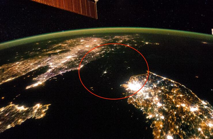
Here’s a photograph of one of the greatest, and longest-running tragedies of our time.

No, that’s not a stretch of water in the red circle.  That’s North Korea, at night, blacked out by a lack of electrical lights.

Tweetpic from the Washington Post: North Korea looks like a sea of misery in this photo from space http://wapo.st/1c1B84q  via @KnowMoreWP pic.twitter.com/nB3g8fa63Q

Tweetpic from the Washington Post: North Korea looks like a sea of misery in this photo from space http://wapo.st/1c1B84q via @KnowMoreWP pic.twitter.com/nB3g8fa63Q

It’s a photo from the International Space Station taken in January.

The KnowMore blog from the Post describes the tragedy, and points to even more disturbing stories:

North Korea appears as nothing more than a shadow in the above photograph, taken at night aboard the International Space Station last month. South Korea’s eastern coastline is indistinguishable from the demilitarized zone along the border with the North, as though the Sea of Japan flowed into the Yellow Sea and Pyongyang were an island in a strait separating South Korea from China.

North Korea’s interior is nearly invisible from orbit at night, just as what happens inside the country on a day-to-day basis is largely invisible to the outside world. U.N. investigators managed to shine a little light into North Korea’s darkest corners last month.  [Click here to get to the U.N. report]

I’ve used similar photos in class.  It’s a powerful exercise.  North Korea is as dark as undeveloped and largely unpopulated areas of the Congo River Basin, the Australian Outback, the Arabian Peninsula’s “Empty Quarter,” and almost as dark as Antarctica.

No doubt stargazing is good in some of those dark spots in North Korea.  This is one case where the absence of light pollution does NOT indicate good planning, but instead an amazing paucity of rational development.


Texas Education Agency looking for social studies books reviewers (and math and fine arts)

December 2, 2013

Last time the SBOE approved social studies books in 2010, the process was contentious.  This photo, from The Christian Science Monitor, shows protests on the books; photo by Larry Kolvoord/Austin American-Statesman

Last time the SBOE approved social studies books in 2010, the process was contentious. This photo, from The Christian Science Monitor, shows protests on the books; photo by Larry Kolvoord, Austin American-Statesman

Good news a few days ago was that the Texas State Board of Education approved science books that teach real science, for use in Texas schools.

But the Road Goes On Forever, and the Tea Party Never Ends:  Social studies books are up for review, now.

TEA is looking for nominations for reviewers for books in social studies, math and fine arts.  Here’s the notice I got in e-mail:

The Texas Education Agency is now accepting nominations to the state review panels that will evaluate instructional materials submitted for adoption under Proclamation 2015.

To nominate yourself or someone else to serve on a state review panel, please complete the form posted at http://www.tea.state.tx.us/WorkArea/linkit.aspx?LinkIdentifier=id&ItemID=25769808256&libID=25769808258 and submit it to the TEA on or before Friday, January 24, 2014.

Proclamation 2015 calls for instructional materials in the following areas:

♦   Social Studies, grades K-12

♦   Social Studies (Spanish), grades K-5

♦   Mathematics, grades 9-12

♦   Fine Arts, grades K-12

State review panels are scheduled to convene in Austin for one week during the summer of 2014 to review materials submitted under Proclamation 2015. The TEA will reserve hotel lodging and reimburse panel members for all travel expenses, as allowable by law.

  • Panel members should plan to remain on-site for five days to conduct the evaluation.
  • Panel members will be asked to complete an initial review of instructional materials prior to the in-person review.
  • Panel members will receive orientation and training both prior to the initial review and at the beginning of the in-person review.
  • Panel members might be asked to review additional content following the in-person review.
  • Because many of the samples will be delivered electronically, panel members should be comfortable reviewing materials on-screen rather than in print.
  • Panel members should also have a working knowledge of Microsoft Excel.

Upon initial contact by a representative of the TEA, state review panel nominees begin a “no-contact” period in which they may not have either direct or indirect contact with any publisher or other person having an interest in the content of instructional materials under evaluation by the panel. The “no contact” period begins with the initial communication from the Texas Education Agency and ends after the State Board of Education (SBOE) adopts the instructional materials. The SBOE is scheduled to adopt Proclamation 2015 materials at its November 2014 meeting.

Nominations are due on or before Friday, January 24, 2014.  The nomination form is posted on the TEA website at http://www.tea.state.tx.us/WorkArea/linkit.aspx?LinkIdentifier=id&ItemID=25769808256&libID=25769808258.

If you have any questions, please contact review.adoption@tea.state.tx.us.

***********************************************************

Thank you for your commitment to serving Texas students.

Social Studies Staff, Division of Curriculum, (512) 463-9581

Social Studies in Texas include history, geography, economics, government (civics), and (oddly) psychology and sociology, and “special topics.”

Please pass word along to the teachers you know in social studies, fine arts and math.

We recall that old Bette Davis line, playing Margot Channing in “All About Eve”:  “Fasten your seatbelts.  It’s going to be a bumpy night.”

More:


Aussie’s view of America; can you do as well for Australia?

November 2, 2013

An Aussie's attempt to label the state of the U.S.  Don't laugh -- how well can you do labeling a map of Australia?  From Texas Hill Country's Facebook feed, and unknown origin past that.

An Aussie’s attempt to label the state of the U.S. Don’t laugh — how well can you do labeling a map of Australia? From Texas Hill Country’s Facebook feed, and unknown origin past that.

Found this at the Facebook site of Texas Hill Country.  A little rough for high school geography, especially if it’s ninth grade geography (surely you can moderate this a bit, teachers), but a good idea for a quiz?

How well can your students do labeling the U.S.?  Will they find this person’s obvious anguish and creative non-answers amusing?  Can they do better?

Now turn the tables:  How well can your students in the U.S. do labeling a map of Australia?  Canada?  Mexico?

Ask your students:  Is it important to know such stuff?  Why?

And you, Dear Reader: What do you think?

Here you go, a map of Australia to practice with:

Unlabeled map of Australia to label!  Royalty free produce of Bruce Jones Design, Inc., copyright 2010

Unlabeled map of Australia to label! Royalty free produce of Bruce Jones Design, Inc., copyright 2010


Is your science class as smart as a U-Haul truck?

October 23, 2013

We had to fight to keep this stuff in Texas science books.

Then, out on the street, I see a U-Haul truck.

U-Haul truck features geographic information, and geology information

U-Haul truck features geographic information, and geology information, about Arkansas and its Crater of Diamonds State Park.

Detail:  U-Haul truck features a graphic description of the geology and information about Arkansas's Crater of Diamonds State Park.

Detail: U-Haul truck features a graphic description of the geology and information about Arkansas’s Crater of Diamonds State Park.

Well played, U-Haul.  Can Texas catch up?

Update, October 24, 2013:  Turns out U-Haul has a website that features all of the graphics they use on their trucks.  I sense a geography or state history assignment in here, somewhere, social studies teachers.  Reminds me of the animals that used to (still do?) grace the tails of Frontier Airlines airplanes, the Native American on the tails of Alaska Airlines, and other specific destination promoting tricks businesses have used over the years.  Wish more businesses would do that.

http://twitter.com/SuperGraphic/status/393408729388834816

More:


Milky Way in the Southern Hemisphere

September 26, 2013

What’s the southernmost unit of the U.S. National Park System?  That’s where this photo was taken.

Stunning southern night sky in Ofu Island in the National Park of American Samoa! They get a brighter, richer view of the Milky Way in the Southern Hemisphere due to the location on the globe. This is the only national park found in the Southern Hemisphere.  Photo: National Park Service

Stunning southern night sky in Ofu Island in the National Park of American Samoa! They get a brighter, richer view of the Milky Way in the Southern Hemisphere due to the location on the globe. This is the only national park found in the Southern Hemisphere. Photo: National Park Service

Many Americans seem unaware of worldwide holdings of the U.S. in territories, thinking the last territory was closed when Oklahoma or Arizona entered the union, or maybe Alaska or Hawaii.  U.S. territories today include the Northern Mariana Islands, Guam (from the Spanish American War), Puerto Rico (from the same war), and the U.S. Virgin Islands, as organized territories.  American Samoa is an “unorganized territory,” along with series of other islands in the Pacific:  Baker Island, Howland Island, Palmyra Atoll, Johnson Atoll, Jarvis Island, Kingman Reef, the Midway Islands, and Wake Island; and in the Caribbean, Bajo Nuevo Bank, Navassa Island (also claimed by Haiti), and Serranilla Bank, also claimed by Colombia.

Most of these islands offer much better star-gazing than is ever possible in Dallas.

More: