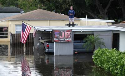
You can’t make this stuff up. Here’s a guy flooded out from his home, where he holds forth claiming climate change isn’t real, and if it is, isn’t a problem.
Will he accept federal aid to fix his home?
You can’t make this stuff up. Here’s a guy flooded out from his home, where he holds forth claiming climate change isn’t real, and if it is, isn’t a problem.
Will he accept federal aid to fix his home?
 1 Comment |
  Climate change, climate_change, Dunning Kruger Effect, Global warming, Green Politics, Politics | Tagged: Climate change, Disasters, Dunning Kruger Effect, Floods, Ft Lauderdale, Global Heating, Karma, Politics |
  Permalink
 Posted by Ed Darrell
With 1000-year flooding having killed two in Ellicott City, Maryland, over the weekend, we should be reminded that delugic rains may increase with global warming.
And we should remember the Big Thompson River flood of July 31, 1976, and its victims.http://www.startribune.com/heating-up-this-week-raging-case-of-weather-amnesia/388762331/
Via the Paul Douglas on Weather blog at the Minneapolis Star-Tribune (one of America’s great newspapers):
![[Thunderhead that produced a slow-moving, and consquently more catastrophic deluge in the headwaters of the Big Thompson River, Colorado, on July 31, 1976.]](https://i0.wp.com/apps.startribune.com/blogs/user_images/pauldouglas_1469933288_cb%20NOAA.GIF)
[Thunderhead that produced a slow-moving, and consquently more catastrophic deluge in the headwaters of the Big Thompson River, Colorado, on July 31, 1976.]
The Big Thompson Disaster: Reverberations of a Flash Flood, 40 Years Later. Dr. Jeff Masters has the post at WunderBlog: “What began as a celebratory Saturday in the mountains ended in tragedy 40 years ago this weekend, when a catastrophic flash flood ripped through the narrow Big Thompson Canyon of Colorado’s Front Range. A total of 144 people were killed on that Saturday evening, July 31, 1976–the eve of the 100th anniversary of Colorado’s statehood. On just about any summer weekend, the canyons northwest of Denver are packed with vacationers and day-trippers. With the state’s centennial falling on this particular weekend, the mood was especially festive, and the weather seemed no more threatening than on many other summer days. Forecasts through the day called for a 40% to 50% chance of showers and thunderstorms, but there was no particular concern about flood risk. Only a few hours later, critical gaps in weather data, communication, and public awareness had teamed up with a slow-moving deluge to create a true disaster–one that’s had a noteworthy influence on how we deal with flash floods today….”
Image credit: NOAA.
Hiking in the area recently, in a different canyon, I reflected on the tremendous changes in weather forecasting in the past 40 years. A lot of warnings about flash floods, and paths to climb up the canyon in emergencies. Plus, we had constant weather updates. Big Thompson was just one of several flood disasters in the 1970s, Masters notes. It’s worth reading his full post.
139 bodies were recovered from the flood, but many other bodies were never recovered. People died from injuries of being tossed about by the flood, and colliding with rocks and trees. Few died of drowning.
How do we prepare to survive and avoid such disasters in the future?
Leave a Comment » | Climate change, climate_change, Disasters, Global warming, History | Tagged: Big Thompson River, Climate change, Disasters, Floods, Global warming, History | Permalink
Posted by Ed Darrell
Help me out, Dear Reader: Here is the English language site of the Russian Federal Atomic Energy Agency (FAEE), the press site. Can you find any statement at this site relating to the power plants in Nebraska along the flooding Missouri River?

What some reports appear to paint as the Nebraska nuclear generating stations (However, please note: In this photo, no nuclear power plants appear)

What you really see: Cooper Nuclear Generating Station in Nebraska -- still there (from a 1993 photo)
I have found no mention of any U.S. incident. This suggests the Pakistani news report of a Russian agency report of disaster is hoax, too.
Claims of a crisis in Nebraska are hoaxes, I think. The Russian agency from which the report is claimed to have come, does not show such a report.
This is more evidence that the whole flap is a hoax.
True to form, several birther and other conspiracy paranoiac sites claim that these plants in Nebraska are gone, in flames, or leaking water that nearly glows.
Can’t Sarah Palin point her bus to Nebraska and let her press entourage get the real story?
8 Comments | Disasters, Hoaxes, Journalism, News, Newspapers, Nuclear power, Rivers | Tagged: Cooper Nuclear Generating Station, Disasters, Floods, Hoaxes, Journalism, Missouri River, Nebraska, News, Newspapers, Nuclear power, Science | Permalink
Posted by Ed Darrell
A Pakistani newspaper, The Nation, should not be confused with the U.S. magazine of the same name, as I originally did.
A shocking report prepared by Russia’s Federal Atomic Energy Agency (FAAE) on information provided to them by the International Atomic Energy Agency (IAEA) states that the Obama regime has ordered a “total and complete” news blackout relating to any information regarding the near catastrophic meltdown of the Fort Calhoun Nuclear Power Plant located in Nebraska.
According to this report, the Fort Calhoun Nuclear Plant suffered a “catastrophic loss of cooling” to one of its idle spent fuel rod pools on 7 June after this plant was deluged with water caused by the historic flooding of the Missouri River which resulted in a fire causing the Federal Aviation Agency (FAA) to issue a “no-fly ban” over the area.
Located about 20 minutes outside downtown Omaha, the largest city in Nebraska, the Fort Calhoun Nuclear Plant is owned by Omaha Public Power District (OPPD) who on their website denies their plant is at a “Level 4” emergency by stating: “This terminology is not accurate, and is not how emergencies at nuclear power plants are classified.”
So, we have some questions to deal with:
As much as we might like to give The Nation a chance at being accurate, how likely is it that a U.S. president could order a complete revocation of emergency safety plans for a nuclear facility, when, by law and regulation, those plans are designed to protect the public? The story smells bad from the start, just on government processes in the U.S.

This is the photograph used by The Nation to illustrate its online article claiming a meltdown at the Fort Calhoun nuclear power station in Nebraska. It shows a flooded nuclear power station, Fort Calhoun we might assume. Is it? Does the photograph show any problem besides the flooding?
The Russian report is too strong, probably. First, there’s no news blackout, as evidenced by local reporting. Second, our American “be-too-conservative-by-a-factor-of-ten” safety standards make piffles sound like major problems. The story’s being filtered through a Pakistani newspaper should give us further pause in taking things at face value.
According to the local Nebraska newspaper, the Omaha World-Herald, the Fort Calhoun facility powered down on April 9 for refueling. Because of the pending floods, it was not yet refired up. A powered-down reactor is unlikely to melt down.
O W-H, Nebraska’s largest and most venerated newspaper, reports on a second problem at a second nuclear plant. Reports on the second “incident” give a clear view into just how careful U.S. plants are usually operated:
Cooper Nuclear Station near Brownville, Neb., declared a “Notification of Unusual Event” about 4 a.m. Sunday when the Missouri River there reached a height of 42.5 feet.
The declaration, which has been anticipated by the power plant’s operators, was made as part of safety and emergency preparedness plan the station follows when flooding conditions are in effect.
The plan’s procedures dictate when the Missouri River’s water level reaches 42.5 feet, or greater than 899 feet above sea level, a notification of unusual event is declared. If the river’s level increases to 45.5 feet or 902 feet above sea level, plant operators are instructed take the station offline as a safety measure.
An earlier story at the O W-H dealt specifically with issues at Fort Calhoun, and the flooding — again suggesting there is little danger from that facility.
FORT CALHOUN, Neb. — Despite the stunning sight of the Fort Calhoun nuclear reactor surrounded by water and the weeks of flooding that lie ahead, the plant is in a safe cold shutdown and can remain so indefinitely, the reactor’s owners and federal regulators say.
“We think they’ve taken adequate steps to protect the plant and to assure continued safety,” Victor Dricks, spokesman for the Nuclear Regulatory Commission, said Thursday.
Tim Burke, vice president at Omaha Public Power District, said the plant’s flood barriers are being built to a level that will protect against rain and the release of record amounts of water from upstream dams on the Missouri River.
“We don’t see any concerns around the Fort Calhoun Nuclear Station,” Burke said at a briefing in Omaha Mayor Jim Suttle’s office.
The nuclear plant, 20 miles north of Omaha, was shut down April 9 for refueling. It has not been restarted because of the imminent flooding.
Who do we believe, a Russian report issued more than 6,000 miles from Nebraska, reported in a newspaper in Pakistan, or the local reporters on the beat?
Photo caption from the Omaha World-Herald: "The Fort Calhoun Nuclear Station from the air Thursday. OPPD was putting the finishing touches on federally ordered flood-defense improvements before flooding began. MATT MILLER/THE WORLD-HERALD"
More, other resources:
UPDATE, June 20, 2011: Let’s call it a hoax
I don’t think I’m going too far out on a limb to call the claims of a serious accident, emergency and potential disaster at the Fort Calhoun site, a hoax. The Russian report — if it exists — may not have been intended as a hoax, but coupled with filtering through the credulous and gullible foreign press (we’re looking at you, Pakistan’s The Nation), it has risen to hoax level, to be debunked. Sure, you should be concerned about safety and security at Fort Calhoun and Cooper — but you should be concerned about safety and security at every nuclear power plant around the world, all the time. This may be a good time for you to reread John McPhee’s brilliant Curve of Binding Energy. It’s dated — Ted Taylor died October 28, 2004 (was his autobiography ever published?) — but still accurate and informative, plus, any excuse to read any work of McPhee is a great one.
14 Comments | Accuracy, Disasters, Hoaxes, Journalism, News, Newspapers, Nuclear power, Science | Tagged: Disasters, First Amendment, Floods, Government, Hoaxes, How do we know what we know, John McPhee, Journalism, Missouri River, Nebraska, News, Newspapers, Nuclear power, Pakistan, Radiation, Russia, Science, Theodore B. Taylor | Permalink
Posted by Ed Darrell

Having a brand new canyon is sort of a once in a lifetime experience. It might even be more rare than that.
Texas’s Canyon Lake Gorge opened to the public last week — a gorge, a canyon, that was carved out over a couple of days in 2002 when flood waters charging over an overtaxed dam cut through soft soils and soft rock to expose millions of years of sediments. Dinosaur footprints were exposed by the flood, too.
A torrent of water from an overflowing lake sliced open the earth in 2002, exposing rock formations, fossils and even dinosaur footprints in just three days. Since then, the canyon has been accessible only to researchers to protect it from vandals, but on Saturday it opens to its first public tour.
“It exposed these rocks so quickly and it dug so deeply, there wasn’t a blade of grass or a layer of algae,” said Bill Ward, a retired geology professor from the University of New Orleans who started cataloging the gorge almost immediately after the flood.
The mile-and-a-half-long gorge, up to 80 feet deep, was dug out from what had been a nondescript valley covered in mesquite and oak trees. It sits behind a spillway built as a safety valve for Canyon Lake, a popular recreation spot in the Texas Hill Country between San Antonio and Austin.
The reservoir was built in the 1960s to prevent flash flooding along the Guadalupe River and to assure the water supply for central Texas. The spillway had never been overrun until July 4, 2002, when 70,000 cubic feet of water gushed downhill toward the Guadalupe River for three days, scraping off vegetation and topsoil and leaving only limestone walls.
Canyon Lake is southwest of Austin, almost due west from San Marcos about 20 miles. The lake backed up from a 1960 flood control project dam built by the U.S. Army Corps of Engineers — the new Canyon Lake Gorge is managed jointly by the Corps and the Guadalupe-Blanco River Authority.
Watch carefully, dear reader: Creationists will soon start to claim that the rapid cutting of this canyon verifies a young age for all canyons, and shows that the Earth’s geology can indeed be very young. But that claim will gloss over the fact that while the gorge was cut quickly, it was cut through sediments that took millions or billions of years to lay down. The Associated Press reports problems with such a hypothesis:
The sudden exposure of such canyons is rare but not unprecedented. Flooding in Iowa in 1993 opened a limestone gorge behind a spillway at Corvalville Lake north of Iowa City, but that chasm, Devonian Fossil Gorge, is narrower and shallower than Canyon Lake Gorge.
Neither compares to the world’s most famous canyon. It took water around 5 million to 6 million years to carve the Grand Canyon, which plunges 6,000 feet at its deepest point and stretches 15 miles at its widest.
The more modest Canyon Lake Gorge still displays a fault line and rock formations carved by water that seeped down and bubbled up for millions of years before the flooding.
Some of the canyon’s rocks are punched with holes like Swiss cheese, and the fossils of worms and other ancient wildlife are everywhere. The rocks, typical of the limestone buried throughout central Texas, date back “111 million years, plus or minus a few hundred thousand years,” Ward said.
Six three-toed dinosaur footprints offer evidence of a two-legged carnivore strolling along the water. The footprints were temporarily covered with sand to protect them as workers reinforced the spillway, but they’ll be uncovered again eventually, Rhoad said.
Tours for the new gorge are booked for the next six months. Details on how to reserve space can be found at the website of the Gorge Preservation Society (GPS).
5 Comments | Geography - Physical, geology, History, Natural history, Science, Texas, Travel | Tagged: Canyon Lake Gorge, Floods, geography, geology, History, Natural history, Science, Texas, Travel | Permalink
Posted by Ed Darrell


Ed Darrell on Texas's Colorado River


Come on in, the water's fine. Come often: Cleanliness is next to godliness.


