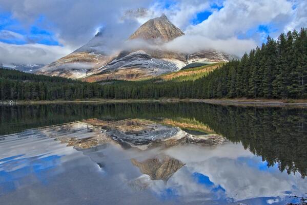
Recently ran across this photo of Utah’s Mt. Timpanogos in the snow. You can see how majestic the mountain is dressed in white, and how its glory can bring awe and joy to people in the valley.
Photo found on Wikipedia, from January 2008.

Recently ran across this photo of Utah’s Mt. Timpanogos in the snow. You can see how majestic the mountain is dressed in white, and how its glory can bring awe and joy to people in the valley.
Photo found on Wikipedia, from January 2008.
 Leave a Comment » |
  Geography - Physical, geology, Mount Timpanogos, photography, Travel, Utah | Tagged: geography, geology, Mt. Timpanogos, photography, Travel, Utah |
  Permalink
 Posted by Ed Darrell
We shouldn’t pass April 19 — a day marked by significant historic events through the past couple hundred years — without remembering that it is also the anniversary of the death of Darwin.

Charles Darwin in 1881, portrait by John Collier; after a Collier painting hanging in the Royal Society
Immortality? Regardless Darwin’s religious beliefs (I’ll argue he remained Christian, thank you, if you wish to argue), he achieved immortality solely on the strength of his brilliant work in science. Of course he’s best known for being the first to figure out that natural and sexual selection worked as tools to sculpt species over time, a theory whose announcement he shared with Alfred Russel Wallace, who independently arrived at almost exactly the same theory but without the deep evidentiary backup Darwin had amassed.
But had evolution turned out to be a bum theory, Darwin’s other works would have qualified him as one of the greatest scientists of all time, including:

Darwin’s theory set out a sequence of coral reef formation around an extinct volcanic island, becoming an atoll as the island and ocean floor subsided. Courtesy of the U.S. Geological Survey (Photo credit: Wikipedia)
US Geological Survey graphic demonstrating how coral atolls form on the sinking remains of old volcanic sea mounts, as Darwin described. Wikimedia commons image
Any of those accomplishments would have been a career-capping work for a scientist. Darwin’s mountains of work still form foundations of geology and biology, and are touchstones for genetics.
Born within a few hours of Abraham Lincoln on February 12, 1809, Darwin survived 17 years longer — 17 extremely productive years. Ill through much of his life with mystery ailments, perhaps Chaga’s Disease, or perhaps some other odd parasite or virus he picked up on his world travels, Darwin succumbed to heart disease on April 19, 1882.
More:
1 Comment | Biology, Charles Darwin, Darwin, Evolution, geology, History, Science | Tagged: Biology, Charles Darwin, Evolution, geology, History, Science | Permalink
Posted by Ed Darrell
Much as the GOP Caucus and other climate-change deniers, Roman officials in Pompeii and Herculaneum refused to be alarmed at the ground shaking, and obvious eruptions from Mount Vesuvius, on August 24, 79 C.E.
In the past week we have earthquakes in California, Nepal, British Columbia, and other places. The old Earth keeps rumbling.
Oddly, we now pay more attention to earthquakes than to other things that can cause greater, rolling disasters.
Santayana’s Ghost wonders if we ever learn from history.

Vesuvius, asleep for now (2013). National Geographic photo by Robert Clark
More:

Yes, this is mostly an encore post. Fighting ignorance requires patience.
Leave a Comment » | Archaeology, Disasters, earthquakes, Geography - Physical, geology, Global warming, Science, Volcanoes | Tagged: 79 AD, 79 CE, Disasters, earthquakes, geology, Global warming, Pompeii, Rome, Vesuvius, Volcanoes | Permalink
Posted by Ed Darrell
Up on the Tioga Pass, Dana Village, Bennettville and the abandoned Golden Crown Mine tell part of the story of the 1890s gold rush in the Sierra Nevada.
Mining in California, okay. Mining at 11,000 feet in the Sierra Nevada, and staying there all winter?
Great history, geography, and explanation that every U.S. history student should know, about gold rushes, about boom towns, about mining entrepreneurs and investors, about failed enterprises and about the aftermath.
Sitting on the crest of the Sierra Nevada, Tioga Pass is a gateway to Yosemite’s past. In 1880, a gold and silver rush erupted here, and miners flocked to Tioga Hill in droves.
Today, the ghosts of these miners work can be seen in the stone walls of Dana Village, rusty machinery at Bennettville, and the log cabins of the Golden Crown Mine. Even today’s popular Tioga Road was once a simple wagon road built to access the wealth of minerals that were never found.
It’s another great production by Steven Bumgardner, featuring two National Park Service rangers, Yenyen Chan and Greg Stock.
More:

Tioga Road. Travelers who took this photo made the drive in a large RV — so you can do it, too. Photo from stillhowlyntravels

Map showing how to get to Tioga Pass in Yosemite National Park (at the eastern end of the red line). Map from Undiscovered-Yosemite.com.
1 Comment | Geography - Physical, geology, History, Mining and Mining Law, National Parks, Travel, Yosemite | Tagged: Boomtowns, California, geography, geology, Ghost Towns, Gold Rush, History, Tioga Pass, Yosemite | Permalink
Posted by Ed Darrell

WFAA Channel 8 map of four quakes confirmed by 10:00 p.m. news casts, showing how close the quakes are in proximity to each other and the site of the old Cowboys Football Stadium.
This Tweet from our local NBC TV affiliate sums it up nicely.
North Texas shook yesterday — not big quakes, but a bunch of ’em — and that doesn’t sit well with Texas oil executives, since it seems likely gas and oil drilling, especially hydraulic fracturing (fracking), and especially waste-water reinjection seem to be causes.
I grew up in Utah. We had quakes you could feel, at least weekly. Our home sat less than a mile west of the Wasatch Fault. Many mornings my mother would stand drinking her coffee, looking over the stove and out our kitchen window at Mt. Timpanogos, remarking on the earthquakes. Most often we couldn’t feel them, but the power and telephone lines that slashed through our $10 million view of the mountain would dance in sine waves during quakes. It was pretty cool.
Along the more famous faults, one rarely comes on more than a couple of quakes a day.
Dallas — more accurately, Irving — is far away from most major faults, and rarely has more than a couple of quakes a year in recent human history.
So this swarm of quakes makes news!
WTVT Channel 11 (CBS) reported:
DALLAS (CBSDFW.COM/AP) – Nine earthquakes, three of them with a 3-point magnitude or greater, rocked North Texas Tuesday into early Wednesday, knocking items off walls, causing cracks to appear in ceilings and generally rattling nerves across the region.
“The last one really shook,” said CBS 11 anchor and reporter Ken Molestina, who felt the the earth move in the White Rock Lake area of Dallas.
The latest quake, reported just before 1 a.m. Wednesday, measured in at a 3.1 magnitude, and was centered near the convergence of State Highway 114, Loop 12, and the Airport Freeway near the old Texas Stadium site in Irving.
Others felt the temblor in the Uptown area of Dallas and as far away as Bedford and Mesquite.
Here’s a list of the quakes in order of when they happened:
7:37 a.m. 2.3 magnitude
3:10 p.m. 3.5 magnitude
6:52 p.m. 3.6 magnitude
8:11 p.m. 2.9 magnitude
8:12 p.m. 2.7 magnitude
9:54 p.m. 1.7 magnitude
10:05 p.m. 2.4 magnitude
11:02 PM 1.6 magnitude
12:59 AM 3.1 magnitude
Rafael Abreu, a geophysicist with the USGS, spoke with NewsRadio 1080 KRLD and said while the Irving earthquakes happened only hours apart, given the strength and intensity, “we’re not calling it an aftershock.”
At last count Tuesday night, there had been 24 or more earthquakes in the Irving area since November 1, 2014.
Jokes fly, too. Not this much shaking since Elvis toured the area heavily in 1957, some say.

Screen capture of USGS reports of four earthquakes in or near Irving, Texas, on January 6, 2014
Recent studies show earthquakes in other areas linked to oil and gas drilling and extraction. All of these quakes are in close proximity to working wells or wells being drilled.
What’s the Earth trying to tell us?

Details from USGS on biggest quake, January 6, 2014
More:
Historically, Texas has not been a hotbed of earthquake activity, between 1973 and 2012. Texas Seismicity Map from USGS.

5 Comments | Dallas, earthquakes, Geography - Physical, geology, History, Oil, Texas | Tagged: Dallas, earthquakes, Fracking, geography, geology, History, Texas | Permalink
Posted by Ed Darrell

Tweet from the Wilderness Society. Devil’s Tower National Monument, in Wyoming, at night. Photo by Alex Weimer, from his flickr feed
Leave a Comment » | Astronomy, Geography - Physical, geology, National Parks, Outdoor Recreation, photography, Travel | Tagged: Astronomy, Devil's Tower National Monument, geography, geology, Outdoor Recreation, photography, Travel, Wyoming | Permalink
Posted by Ed Darrell
It’s a 17-second video, a compilation of photos (over how much time?) showing the December 29, 2014 eruption of Popocatépetl.
Published on Dec 29, 2014
Fuente: http://www.webcamsdemexico.com
Twitter https://twitter.com/webcamsdemexico
Eruptions are captured by webcamsdemexico, which is another indication that good, inexpensive electronic imaging devices change the way we study and experience natural events in the world today.
17 seconds of great drama. Are there other good images from this eruption?

Satellite photo of Popocatepetl, earlier. Image via CNN/Mexico
More:
Leave a Comment » | Geography - Physical, geology, Mexico, Science, Volcanoes | Tagged: geography, geology, Mexico, Popocatepetl, Science, Volcanoes | Permalink
Posted by Ed Darrell
Department of Interior, May 18, 2014 — Here’s our most popular photo on social media last week celebrating @GlacierNPS 104th birthday. pic.twitter.com/JNaYYNnfcH
Glacier National Park marks its 104th year in 2014. Glacier offers views this spectacular every day of the year.
3 Comments | Geography - Physical, geology, National Parks, photography, Travel | Tagged: geography, geology, Glacier National Park, photography, Travel | Permalink
Posted by Ed Darrell
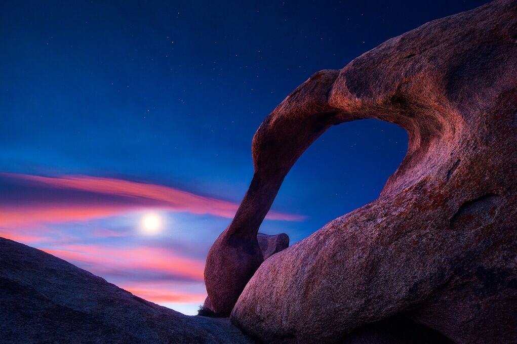
U.S. Department of Interior, Twitter feed: Beautiful view of the Moon over Mabius Mobius Arch in the Alabama Hills Recreation Area. #California @BLMca pic.twitter.com/u0KYyJ6p0S
Interesting points, reasons to like this image:
More:
2 Comments | Bureau of Land Management (BLM), Geography - Physical, geology, Hiking, photography, Public Lands, Travel | Tagged: Alabama Hills Recreation Area, BLM, California, geography, geology, Hiking, Mobius Arch, photography, Travel | Permalink
Posted by Ed Darrell
We shouldn’t pass April 19 — a day marked by significant historic events through the past couple hundred years — without remembering that it is also the anniversary of the death of Darwin.
Charles Darwin in 1881, portrait by John Collier; after a Collier painting hanging in the Royal Society
Immortality? Regardless Darwin’s religious beliefs (I’ll argue he remained Christian, thank you, if you wish to argue), he achieved immortality solely on the strength of his brilliant work in science. Of course he’s best known for being the first to figure out that natural and sexual selection worked as tools to sculpt species over time, a theory whose announcement he shared with Alfred Russel Wallace, who independently arrived at almost exactly the same theory but without the deep evidentiary backup Darwin had amassed.
But had evolution turned out to be a bum theory, Darwin’s other works would have qualified him as one of the greatest scientists of all time, including:
Darwin’s theory set out a sequence of coral reef formation around an extinct volcanic island, becoming an atoll as the island and ocean floor subsided. Courtesy of the U.S. Geological Survey (Photo credit: Wikipedia)
US Geological Survey graphic demonstrating how coral atolls form on the sinking remains of old volcanic sea mounts, as Darwin described. Wikimedia commons image
Any of those accomplishments would have been a career-capping work for a scientist. Darwin’s mountains of work still form foundations of geology and biology, and are touchstones for genetics.
Born within a few hours of Abraham Lincoln on February 12, 1809, Darwin survived 17 years longer — 17 extremely productive years. Ill through much of his life with mystery ailments, perhaps Chaga’s Disease, or perhaps some other odd parasite or virus he picked up on his world travels, Darwin succumbed to heart disease on April 19, 1882.
More:
Leave a Comment » | Biology, Charles Darwin, Darwin, Evolution, geology, History, Science | Tagged: Biology, Charles Darwin, Evolution, geology, History, Science | Permalink
Posted by Ed Darrell
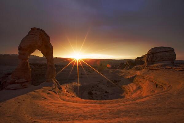
From the U.S. Department of Interior: This stunning photo of dusk @ArchesNPS by Jonathan Backin is the perfect way to end the week. #utah #nature pic.twitter.com/5bIanEG8sZ
Delicate Arch, with a dusting of snow, as the sun sets.
A great reason to live in Moab, Utah, or visit there.
Leave a Comment » | Geography - Physical, geology, National Parks, Travel, Utah | Tagged: Arches National Park, Delicate Arch, Department of Interior, geography, geology, Jonathan Backin, Moab, Photogarphy, Travel, Utah | Permalink
Posted by Ed Darrell

Lightning strikes in Monument Valley, on the Navajo Reservation, Utah. Photography by Carolyn Slay (Oak Ridge, TN); Monument Valley, UT Feb. 20 2014 Via smithsonianmag.com.
Lightning strike in Monument Valley, photo by Carolyn Slay of Oak Ridge, Tennessee; Smithsonian Magazine Tumblr Photo of the Day, February 20, 2014.
Rocks on the right can also be seen in this photo; can you help pinpoint the location of the photographer, and names of any of the other formations?
Leave a Comment » | Geography - Physical, geology, Navajo, Travel, Utah | Tagged: geography, geology, Monument Valley Navajo Tribal Park, Travel, Utah | Permalink
Posted by Ed Darrell
It’s an interesting town, Dinosaur, Colorado 81610. It’s on the south side of US Highway 40, a very short distance east of the Utah border.
And it touches on the Colorado part of Dinosaur National Monument. The Wikipedia entry gives specifics:
The Town of Dinosaur is a Statutory Town located in Moffat County, Colorado, United States. The town population was 339 at the 2010 census.[5]
The town of Dinosaur was originally named Artesia; the current name was adopted in 1966, to capitalize on the town’s proximity to Dinosaur National Monument.[6] The monument headquarters is located just east of the town on U.S. Highway 40.
And:
Many streets in the town are named after dinosaurs, including Cletisaurus Circle, Tyrannosaurus Trail, and Antrodemus Alley.[8]
It’s a setup, a straight line waiting for a good comedian.
Brian Switek, the science writer now based in Salt Lake City, suggests one area ripe for comedy:
http://twitter.com/Laelaps/status/417128850762391553
Wait. What? Dinosaur Baptist Church?
Brian Tweeted that he wasn’t looking to ridicule, but: “I just imagined thyreophorans, maniraptorans, sauropodomorphs, and their ilk in the congregation.”
That might produce even more comedic situations.
It’s a Southern Baptist Convention-affiliated congregation. Aren’t you curious how Sunday school goes for dinosaur-crazy kids in such a church, in such a town?
Signs of life, signs of the times, signs of something!
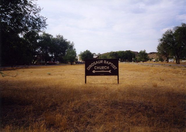
Another shot of the directional sign for Dinosaur Baptist Church, from earlier in 2011, I think. From Text of the Day.
From a different angle, one can see that the church is just a couple of blocks off of Stegosaurus Freeway. Wow.

2007 photo of the sign showing street signs at the intersection of 6th Street and Stegosaurus Freeway. Photo by Will Gelnaw, who has copyright to it.
Still, it’s fun to imagine a nice, small town church, with dinosaurs in the back pews singing along. (Instead, Chris Clarke suggested, they are hiding in the Rocks of Ages . . .)
More:

Welcome to Dinosaur, Colorado (Photo credit: J. Stephen Conn)
1 Comment | Creationism, Dinosaurs, Evolution, Geography - Physical, geology, Humor, Religion, Travel | Tagged: Dinosaur Colorado, Dinosaur National Monument, geography, Humor, Signs, Travel | Permalink
Posted by Ed Darrell

Photo and caption from Milwaukee Journal-Sentinel: Does Lake Michigan’s record low mark beginning of new era for Great Lakes? At least 150 years of rhythmic pulses in Lake Michigan’s water levels appear to have shifted abruptly with loss of winter ice. Photo by Mark Hoffman, Milwaukee Journal-Sentinel
Don’t get complacent, yet. Has enough water fallen in the Great Lakes drainage area in the past six months to change this situation at all? From the New York Times last June:
Drought and other factors have created historically low water marks for the Great Lakes, putting the $34 billion Great Lakes-St. Lawrence Seaway shipping industry in peril, a situation that could send ominous ripples throughout the economy.
Water levels in the Great Lakes have been below their long-term averages during the past 14 years, and this winter the water in Lakes Michigan and Huron, the hardest-hit lakes, dropped to record lows, according to the Army Corps of Engineers. Keith Kompoltowicz, the chief of watershed hydrology with the corps’s Detroit district, said that in January “the monthly mean was the lowest ever recorded, going back to 1918.”
While spring rains have helped so far this year, levels in all five Great Lakes are still low by historical standards, so getting through the shallow points in harbors and channels is a tense affair.
It’s not just storms, rising sea levels, and melting glaciers, you know.

The Great Lakes from space. The Great Lakes are the largest glacial lakes in the world. NASA photo via Wikipedia
More:

Great Lakes in Sunglint (NASA, International Space Station, 06/14/12) (Photo credit: NASA’s Marshall Space Flight Center)
2 Comments | Climate change, climate_change, Geography - Economic, Geography - Physical, geology, Global warming, History, Science, Water | Tagged: Climate change, Geograpnhy, geology, Global warming, Great Lakes, History, National Oceanic and Atmospheric Administration, NOAA, Science | Permalink
Posted by Ed Darrell
Or any other time of year.
From the Department of Interior Twitter feeds:
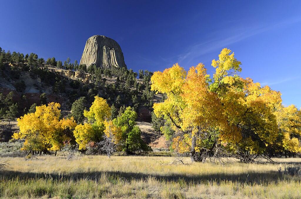
US Dept of Interior @Interior 16h Is there any doubt fall is best enjoyed in America’s great outdoors? Here’s great example from Devils Tower NM. pic.twitter.com/YRo1U8DSMQ
What do you think Richard Dreyfus thinks when he sees that? Stephen Spielberg?
“Devils Tower NM” means “National Monument,” not New Mexico. This volcano remnant stands in Wyoming.
Old friend, painter and photographer Nancy Christensen Littlefield offers a more close-up view.

Devil’s Tower on a July morning. Photo by Nancy Christensen LIttlefield.
And looking even closer, you spy Richard Dreyfus never-wanna-bes:

Climbers on Devils Tower. Photographer Nancy Littlefield said: “There were Native American prayer bundles along the trail around the base. It really is awe inspiring. Early morning gives you the best light to photograph it by.”
Devils Tower is the plug of an old volcano. What’s left is the magma that hardened, and what we see is left after the softer cone eroded away.
More:

United States Flag and Devils Tower National Monument – Wikipedia image
Leave a Comment » | Geography - Physical, geology, History, National Parks, Theodore Roosevelt, Travel | Tagged: Antiquities Act, Devils Tower, geography, geology, History, National Monuments, Travel | Permalink
Posted by Ed Darrell
You are currently browsing the archives for the geology category.


Ed Darrell on Texas's Colorado River


Come on in, the water's fine. Come often: Cleanliness is next to godliness.


