December 4, 2007

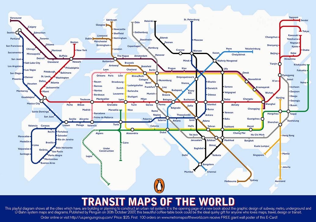
Fun map. Readers at Strange Maps noted lots of geographical challenges in these train routes. Wouldn’t this make a great warm-up/bell-ringer, to have students find the geographical difficulties, errors and impossibilities?
And then there’s the book itself. The perfect gift for Dr. Jack Rhodes*, perhaps, or for Jim Lehrer, or someone else to whom transportation has been a great and grand pastime, as it has been for author Mark Ovenden.

Cool. Funny. Maybe instructive.
This would be a heckuva two-week study in geography, no? There are those great films on the construction of the New York subway system; there must be wonderful photos of the art in the Moscow system.
Or am I being too pedantic?
(Click thumbnail below for a larger view of the map.)
Tip of the old scrub brush, and go visit, Strange Maps.
* Jack Rhodes was director of forensics at the University of Utah when I was an undergraduate there — my old debate coach. He was so familiar with bus and train schedules, as a hobbyist, that we frequently tried to stump him with questions about a passing train or bus we’d see driving around the nation. To my knowledge, he always got the name of the train right, and the bus’s scheduled next stop right. You sorta had to be there, but it was an amazing series of feats of memory.
Spread the word; friends don't allow friends to repeat history.
 3 Comments |
  Bell Ringers, Books, Geography - Physical, Harry Wong, Technology, Transportation, Warm-up exercises | Tagged: Books, Education, geography, Maps, public transit, subway |
  Permalink
 Posted by Ed Darrell
December 2, 2007
I’m not sure exactly why, but my post on ocean foam in Australia continues to be one of the most popular.
Now you can make ocean foam in your classroom! I suppose this was planned for a science class, but why not use it in geography or world history?

Instructions here: What Molecules are in Ocean Foam? (repeated below the fold). This is one of several easy-to-do science experiments promoted at the Pfizer Foundation Discovery Lab at the New York Hall of Science.
Also see this explanation from New Scientist about how foam forms on ocean waves in the first place.
Go ahead. Cover the entire school with it.
Read the rest of this entry »
Spread the word; friends don't allow friends to repeat history.
3 Comments | Bell Ringers, Geography - Physical, Lesson plans, Natural history, Science, Warm-up exercises | Tagged: classroom activities, Lesson plans, ocean foam | Permalink
Posted by Ed Darrell
November 27, 2007
Do your students ever ask why we bother to study geography? Consider these sources for a one-day exercise in geography, world history or U.S. history:
How U.S. forces took back Baghdad

Geographic Travels with Catholicgauze alerts us to this interesting story of applied geography.
The map of Baghdad, above, was found in a raid on an al Quaeda house in the past year. It details the organization of al Quaeda, especially with regard to shipping guns, ammunition and explosives into Baghdad.
Armed with this knowledge, U.S. forces set about severing each of the cells from each other, separating the pieces of the snake to kill the beast.
Here is the New York Times story. (So much for wild claims that “mainstream media” do not cover such news.) Here is the Fox News story, with a link to a .pdf version of the map.
A map drawn by Al Qaeda in Iraq leader Abu Musab al-Zarqawi — who was killed last year by U.S. forces — turned up last December in an Al Qaeda safe house and essentially gave U.S. war planners insight into the terrorist group’s methods for moving explosives, fighters and money into Baghdad.
“The map essentially laid out how Al Qaeda controlled Baghdad. And they did it through four belts that surrounded the city, and these belts controlled access to the city for reinforcements and weapons and money,” said Maj. Gen. Bob Scales, a FOX News contributor who recently visited Iraq.
That’s what geographic knowledge can do. It can be the difference between peace and war, the difference between life and death.
Spread the word; friends don't allow friends to repeat history.
2 Comments | Geography - Physical, Geography - Political, History, Iraq, War, War on Terrorism | Tagged: al Quaeda, Education, geography, History, Iraq, Terrorism | Permalink
Posted by Ed Darrell
November 25, 2007
Over 100 million boys in the U.S. have repeated the Scout Law, “Trustworthy, Loyal, Helpful, Friendly, Courteous, Kind, Obedient, Cheerful, Thrifty, Brave, Clean, Reverent.”
Jerry Mika of Draper, Utah, lives it.

Mika returned a check for $2,245,342 that the State of Utah had sent him in error (see the Associated Press story in the Provo Daily Herald — photo, above, by Jeremy Harmon, Salt Lake Tribune).
Mika returned the check — a mistake that occurred when an employee entered a serial number, not an amount — to state finance offices Wednesday.
“Clearly we have an honest, honest citizen. I wish I could do something more than say thanks,” commerce department director Francine Giani said.
Can’t Utah grant him a kingdom — half of Millard County or something? A little duchy in Fillmore, Utah?
Mika, who runs the nonprofit Providence Foundation to help Nepalese sherpas, said he’s had great fun showing off the state’s mistake.
“Everybody looked at it, started giggling and asked why I wasn’t already in Switzerland,” he said.
He admits to being tempted to deposit the money and draw a bit interest before the state asked for its return.
“That money would have gone a long way,” he said.
When a company comptroller complained to me once that the $4 million in refunds to our company would mess up his quarterly bookkeeping because he expected the money in the next quarter, I volunteered to park the money in an account for him. He quickly came to his senses. At low, passbook interest rates, the $4 million would have paid $141/hour, 24 hours a day — more than $3,300 a day. A few weeks of that and you’re talkin’ big money.
Because the check was state-issued, cashing it would probably have been easy, despite the large amount, Giani said.
“It was a valid check,” said Rick Beckstead, the state accounting operation manager whose signature is stamped on the check.
How honest are you, Dear Reader? How much of a temptation would it have been to cash that check? (I’ll wager this man is a former Boy Scout; how much does that account for his actions?)
Perhaps you could reward Mr. Mika’s honesty with a contribution to the foundation he operates, The Providence Foundation.
Teachers: Can you see how to make this into a bell-ringer, warm-up exercise?
Read the rest of this entry »
Spread the word; friends don't allow friends to repeat history.
8 Comments | Bell Ringers, Boy Scouts of America, Business Ethics, Economics, Ethics, Geography - Physical, Harry Wong, Humor, Warm-up exercises | Tagged: Boy Scouts, Business, Economics, Ethics, honest man, Humor, Sherpas | Permalink
Posted by Ed Darrell
November 21, 2007
Worldwide fans of Robin Hood should be concerned: Sherwood Forest is not even a ghost of what it once was.
The Associated Press carried a story detailing efforts to preserve and revive the forest made famous by the stories of Robin Hood. 900-year-old oaks, encroaching development, a sense of history, and a need to save green space — it’s a good story for warm-up on conservation, development, historical myths, or England’s geography.
Spread the word; friends don't allow friends to repeat history.
Leave a Comment » | Economics, Environmental protection, Geography - Economic, Geography - Physical, Heroes, History, World history | Tagged: Environmental protection, geography, Robin Hood, Science, Sherwood Forest | Permalink
Posted by Ed Darrell
November 19, 2007
This is cool. Natural phenomena, the stuff that makes geography really interesting — where and what is this? (Pictures from August 2007)

It was as if someone had poured tons of coffee and milk into the ocean, then switched on a giant blender.
Suddenly the shoreline north of Sydney were transformed into the Cappuccino Coast.
Foam swallowed an entire beach and half the nearby buildings, including the local lifeguards’ centre, in a freak display of nature at Yamba in New South Wales.
One minute a group of teenage surfers were waiting to catch a wave, the next they were swallowed up in a giant bubble bath. The foam was so light that they could puff it out of their hands and watch it float away.
Perhaps a good geography warm-up: Where are these pictures from? What is the phenomenon shown in the photos? Why might it be unusual for these people to be swimming in the ocean in August?
Read the rest of this entry »
Spread the word; friends don't allow friends to repeat history.
8 Comments | Geography - Physical, Natural history, Natural resources, Science, Travel | Tagged: Australia, geography, natural phenomena, ocean foam, wave action | Permalink
Posted by Ed Darrell
November 15, 2007
Day in and day out, this cartoon of a poor African kid getting hit by a tsunami of drought is among the most popular posts on this blog, and one of the most popular cartoon images on the web. I think the cartoonist Alberto Sabat was trying to make a point, that kids in SubSaharan Africa were (are) being clobbered by a disaster as great as the great tsunami that hit the Indian Ocean after Christmas 2005.
In other words, there were other disasters, other victims, and we ignore them.
If Al Gore had a lot of media clout and enjoyed bias from media in his favor, you’d hear about a great storm ready to smash one of the poorest, lowest countries on the planet, where recent increases in povery-struck populations has put millions of people in a great river’s delta, in a most dangerous place to be in a cyclone. But you’re not hearing the story.
If our news media were biased to the liberal side, a story about such a pending disaster would be on the front page of every liberal newspaper, and leading every liberal television news broadcast.
If our private charity groups were groveling to the climate change Cassandras, they’d be begging for money to evacuate people from the path of a category 5 cyclone, now.
If Katrina’s aftermath alerted us to the dangers of powerful storms hitting areas of great poverty, we’d be glued to our television sets if there were another such drama unfolding anywhere on Earth.
If the Bush administration were concerned about preventing the growth of al Quaeda and similar movements, it would be doing what it could to help out a nominally friendly government of an Islamic nation in the path of a great storm.
Right?
The photos are spectacular. The news is . . . eerily quiet.

This is Cyclone Sidr. It’s a category 5, and it keeps defying predictions that it will weaken as it moves north, oddly acting as if it has targeted the low river delta regions of Bengla Desh. Chris Mooney calls it “beautiful but deadly.” P. Z. Myers raises an alarm about our ignorance of the storm. More details from Mooney. Lamentations from Mooney’s co-blogger Kirshenbaum (are they playing the role of Jeremiah or Cassandra? Rather depends on your reaction, no?)
Do any high school geography, world history, government or economics courses still do current events? Here’s the raw material for a good, consciousness-raising warm-up. Prelude to a disaster, we hope not. The lack of news coverage is disturbing.
Resources:
Horrible thought: Is the dearth of reaction partly because broadcasters don’t know how to pronounce the name of the storm?
Spread the word; friends don't allow friends to repeat history.
5 Comments | Climate change, Disasters, Geography - Economic, Geography - Physical, Geography - Political, History, Politics, Poverty | Tagged: Cyclone Sidr, natural disaster, political disaster, Politics, Science | Permalink
Posted by Ed Darrell
November 10, 2007

Nobel-winner economist Joseph Stiglitz is in Ethiopia. His comments on the value and the problems of economic development in order to fight poverty could provide important background or discussion material for your economics unit on international economics, international trade, and world financing systems.
Spread the word; friends don't allow friends to repeat history.
2 Comments | Bell Ringers, Economics, Geography - Economic, Geography - Physical, Government, Poverty, Warm-up exercises | Tagged: Africa, economic development, Ethiopia | Permalink
Posted by Ed Darrell
November 5, 2007

Yes, there really are mountains of such stark beauty, in Utah, next to civilization.
Spread the word; friends don't allow friends to repeat history.
3 Comments | Geography - Physical, geology, Humor, Personal | Tagged: Ed Darrell, geography, geology, Mt. Timpanogos, Utah | Permalink
Posted by Ed Darrell
November 4, 2007
Yellowstone National Park is just a cool place. If you’re not using it for anything in your geography and U.S. history courses, you’re missing out.
Here’s a ten-minute video that the producers hope you’ll show far and wide to encourage television stations to pick up the series. It’s a ten-minute pilot for “Travelers’ Tales,” featuring outdoor writer Tim Cahill, a founder of Outside magazine, and photographer Tom Murphy.
Here are some of the points you might use in class:
- Yellowstone in winter, especially the wildlife, like bison, elk and coyotes (all shown), and wolves (not shown)
- Volcanic geology — Yellowstone is the world’s largest caldera, after all
- Diversity of landforms in the U.S., or in the world. More than half the hot water features on the planet are in Yellowstone
- Travel and adventure
- What makes good writing (travel writing in this case)
- Western geography
- Development of the west, especially after the Lewis and Clark Expedition
The video features a lot of snow, elk, bison and coyotes, hot springs flowing into a river making swimming in January feasible, Mammoth Hot Springs and the travertine pools, and the cold northern desert of sagebrush and juniper.
Questions you might consider to turn this into a warm-up exercise (bell ringer):
Geography, not answered in the video (map or internet exercise):
- Yellowstone National Park covers parts of which three states?
- Yellowstone National Park is mostly located in which state?
- What is the most famous feature of Yellowstone National Park?
- Ashfall Beds State Park features ancient mammals killed by an eruption in the Yellowstone Caldera. Where is Ashfall Beds State Park?
- Thomas Moran played a key role in getting Congress to designate Yellowstone as a park. What did he do to help convince Congress to act?
Geography, answered in the video:
- What year was Yellowstone designated a National Park by Congress?
- What sort of volcanic feature is the entire Yellowstone area?
- The Yellowstone Caldera explodes catastrophically about every 600,000 years, according to some geologists. How long has it been since the last such catastrophic explosion?
- The wags say there are two seasons in Yellowstone, ______ and winter.
- What is a “hot pot?”
Spread the word; friends don't allow friends to repeat history.
2 Comments | Adventure, Bell Ringers, Geography - Physical, geology, Natural history, Natural resources, Travel, Warm-up exercises | Tagged: geography, geology, Lesson plans, Tim Cahill, Travel, video, Yellowstone | Permalink
Posted by Ed Darrell
November 4, 2007
You won’t find this in your world history text.
Events in Congo trouble at so many levels. Reports in The New York Times and other places document unspeakable violence: 27,000 sexual assaults in South Kivu Province in 2006, just a fraction of the total number across the nation of 66 million people. The assaults are brutal. Women assaulted are often left so badly injured internally, they may never heal.
 Map of Congo, highlighting province of Bukavu where violence against women is epidemic, from New York Times
Genocide you say? Many assaults appear to be spillover from the Hutu-Tutsi conflict in next-door Rwanda. But assaults by husbands on wives also are epidemic. Result of civil war? Then how to explain the “Rasta” gang, dreadlocked fugitives who live in the forest, wear tracksuits and Los Angeles Lakers jerseys, and who commit unspeakable crimes against women and children? What nation are they from, and against whom do they fight, if anyone — and for what?
The facts cry out for action:
- Nightly rapes of women and girls. The violence appears to be a problem across the nation.
- Huge chunks of Congo have no effective government to even contend against the violence.
- Killers with experience in genocide in their native Rwanda moved into Congo; they live by kidnapping women for ransom. The women are assaulted while held captive. Sometimes husbands do not take back their wives.
- The oldest rape victim recorded by one Congo physician is 75; the youngest, 3.
Surely intervention by an international group would help, no? However
- Congo hosts the largest single peacekeeping mission of the United Nations right now, with 17,000 troops. Congo is a big nation, bordered by nine other nations. How many troops would it take to secure the entire nation, or the entire border? No one knows.
- 2006 saw an election that was supposed to remake history, end the violence and start Congo on the road to recovery; but was the $500 million it cost enough to change Congo’s history of a string of bad governments?
- International attention focuses on other crises: Iraq, Afghanistan, Sudan and Darfur, Iran, Korea, Chechnya, Turkey and the Kurds, Palestine and Israel. Congo, constantly roiling since the 1960s, is way down the list of world concerns, no matter how bad the violence.
Americans looking for a quick resolution to the situation in Iraq might do well to study Congo. At Congo’s independence in the 1960s, there was hope of prosperity and greater peace. Foreign intervention, including meddling from the U.S., regional civil wars, bad government and long international neglect, ate up the hope. Achieving what a nation could be is difficult, when so many forces align to prevent it from being anything other than a violent backwater. Pandora’s box resists attempts to shut it. Quick resolution is unlikely.
So the violence in Congo continues. In this world, when is the “never” in “never again?”
How many other such cases fall outside our textbooks, and off the state tests?
Resources:
- Nicholas Kristof’s blog at the New York Times website seeks solutions for Congo, with a focus on “what you can do.”
- Congo war crimes suspect in custody, at the Hague (NY Times)
- Letters on the issue, including one from the founders of “V-Day,” an international drive against sexual violence
- Guardian Unlimited, “UN probes 10 years of Congo slaughter”
- Guardian Unlimited Special Report: Congo
- “Why the Congo matters,” from Friends of the Congo (a solid report from a non-governmental organization that leans to the left, some say — see Patrice Lumumba in the banner)
- AllAfrica.com – news from Congo
- 7th anniversary of the UN resolution, “Women, Peace and Security,” UN Mission in the Democratic Republic of the Congo
- Conference of NGOs in Consultative Relationship with UN CONGO
- Travel guide to the Congo
- University of Pennsylvania African Studies Center, page on Congo
- Wikipedia entry on Congo
- Coltan (columbite-tantalite), the ore from which tantalum is refined, a substance important to computer chips manufacturing
- Blood diamonds
Spread the word; friends don't allow friends to repeat history.
2 Comments | Africa, Disasters, Economics, Genocide, Geography - Economic, Geography - Physical, Geography - Political, History, Human Rights, Natural resources, Politics | Tagged: Africa, Congo, Genocide, Human Rights, Politics, World history | Permalink
Posted by Ed Darrell
October 28, 2007
It’s a toe in the water of internet-using instruction. Here’s a syllabus for a 7th grade Texas history class at Pin Oak Middle School in the Houston Independent School district.
Notice that this class, as many in Texas do, puts the geography unit up front, not quite isolated from the rest of the class. Regardless of how well geography is covered, I think we end up shorting the subject its due.
Kudos to Pin Oak MS, to Mr. Gomez, and I hope to see more.
(Surely there is a class in Texas that is farther along in integrating the internet into the Texas history curriculum — point them to us, Dear Readers?)
Spread the word; friends don't allow friends to repeat history.
Leave a Comment » | Geography - Physical, Geography - Political, History, Teaching, Technology in the classroom, Texas history | Tagged: Technology in the classroom, Texas history | Permalink
Posted by Ed Darrell
October 9, 2007

Having a brand new canyon is sort of a once in a lifetime experience. It might even be more rare than that.
Texas’s Canyon Lake Gorge opened to the public last week — a gorge, a canyon, that was carved out over a couple of days in 2002 when flood waters charging over an overtaxed dam cut through soft soils and soft rock to expose millions of years of sediments. Dinosaur footprints were exposed by the flood, too.
A torrent of water from an overflowing lake sliced open the earth in 2002, exposing rock formations, fossils and even dinosaur footprints in just three days. Since then, the canyon has been accessible only to researchers to protect it from vandals, but on Saturday it opens to its first public tour.
“It exposed these rocks so quickly and it dug so deeply, there wasn’t a blade of grass or a layer of algae,” said Bill Ward, a retired geology professor from the University of New Orleans who started cataloging the gorge almost immediately after the flood.
The mile-and-a-half-long gorge, up to 80 feet deep, was dug out from what had been a nondescript valley covered in mesquite and oak trees. It sits behind a spillway built as a safety valve for Canyon Lake, a popular recreation spot in the Texas Hill Country between San Antonio and Austin.
The reservoir was built in the 1960s to prevent flash flooding along the Guadalupe River and to assure the water supply for central Texas. The spillway had never been overrun until July 4, 2002, when 70,000 cubic feet of water gushed downhill toward the Guadalupe River for three days, scraping off vegetation and topsoil and leaving only limestone walls.
Canyon Lake is southwest of Austin, almost due west from San Marcos about 20 miles. The lake backed up from a 1960 flood control project dam built by the U.S. Army Corps of Engineers — the new Canyon Lake Gorge is managed jointly by the Corps and the Guadalupe-Blanco River Authority.
Watch carefully, dear reader: Creationists will soon start to claim that the rapid cutting of this canyon verifies a young age for all canyons, and shows that the Earth’s geology can indeed be very young. But that claim will gloss over the fact that while the gorge was cut quickly, it was cut through sediments that took millions or billions of years to lay down. The Associated Press reports problems with such a hypothesis:
The sudden exposure of such canyons is rare but not unprecedented. Flooding in Iowa in 1993 opened a limestone gorge behind a spillway at Corvalville Lake north of Iowa City, but that chasm, Devonian Fossil Gorge, is narrower and shallower than Canyon Lake Gorge.
Neither compares to the world’s most famous canyon. It took water around 5 million to 6 million years to carve the Grand Canyon, which plunges 6,000 feet at its deepest point and stretches 15 miles at its widest.
The more modest Canyon Lake Gorge still displays a fault line and rock formations carved by water that seeped down and bubbled up for millions of years before the flooding.
Some of the canyon’s rocks are punched with holes like Swiss cheese, and the fossils of worms and other ancient wildlife are everywhere. The rocks, typical of the limestone buried throughout central Texas, date back “111 million years, plus or minus a few hundred thousand years,” Ward said.
Six three-toed dinosaur footprints offer evidence of a two-legged carnivore strolling along the water. The footprints were temporarily covered with sand to protect them as workers reinforced the spillway, but they’ll be uncovered again eventually, Rhoad said.
Tours for the new gorge are booked for the next six months. Details on how to reserve space can be found at the website of the Gorge Preservation Society (GPS).
Spread the word; friends don't allow friends to repeat history.
5 Comments | Geography - Physical, geology, History, Natural history, Science, Texas, Travel | Tagged: Canyon Lake Gorge, Floods, geography, geology, History, Natural history, Science, Texas, Travel | Permalink
Posted by Ed Darrell
October 7, 2007
Teachers looking for good interactive graphics on human migration in prehistoric times should take a look at the website of Australia’s Bradshaw Foundation. The map requires an Adobe Flash player, and I cannot embed it here — but go take a look, here. “The Journey of Man” seems tailor made for classroom use, if you have a live internet connection and a projector.
Ancient art is the chief focus of the foundation.
 Examples of some of the most famous cave and rock paintings populate the site, along with many lesser known creations — the eponymous paintings, the Bradshaw group, generally disappear from U.S. versions of world history texts. The Bradshaw Foundation website explains:
The Bradshaw Paintings are incredibly sophisticated, as you will see from the 32 pictures in the Paintings Section, yet they are not recent creations but originate from an unknown past period which some suggest could have been 50,000 years ago. This art form was first recorded by Joseph Bradshaw in 1891, when he was lost on an Kimberley expedition in the north west of Australia. Dr. Andreas Lommel stated on his expedition to the Kimberleys in 1955 that the rock art he referred to as the Bradshaw Paintings may well predate the present Australian Aborigines.
This ancient art carries a story that should intrigue even junior high school students, and it offers examples of archaeological techniques that are critical to determining the ages of undated art in the wild:
According to legend, they were made by birds. It was said that these birds pecked the rocks until their beaks bled, and then created these fine paintings by using a tail feather and their own blood. This art is of such antiquity that no pigment remains on the rock surface, it is impossible to use carbon dating technology. The composition of the original paints cant be determined, and whatever pigments were used have been locked into the rock itself as shades of Mulberry red, and have become impervious to the elements.
Fortuitously, in 1996 Grahame Walsh discovered a Bradshaw Painting partly covered by a fossilised Mud Wasp nest, which scientists have removed and analysed using a new technique of dating, determining it to be 17,000 + years old.
Texas history and geography teachers should note the Bradshaw Foundation’s work on prehistorica art in the Pecos River Valley: “Pecos Experience: Art and archeaology in the lower Pecos.” There is much more here than is found in most Texas history texts — material useful for student projects or good lesson plans.

Spread the word; friends don't allow friends to repeat history.
Leave a Comment » | Archaeology, Art, Geography - Physical, History and art, History images, Lesson plans, Maps, Prehistory, Technology in the classroom, TEKS, Texas, Texas history | Tagged: Archaeology, Australia, Bradshaw Foundation, human migration, prehistoric humans, Texas | Permalink
Posted by Ed Darrell
September 28, 2007
Tehran 24 ran a photo of a huge clock somewhere in Tehran, under the headline of “The World’s Biggest Clock.”

But is it more than 37 feet across, like the flower clock in Las Colinas, Irving, Texas?*

What is the biggest clock in the world? Surely there are some bigger.
* This site says the Tehran clock is 15 meters across — bigger than Las Colinas. The clock faces accompanying the bell of Big Ben are 7 meters across. For a panoramic view of the belfry of Big Ben, see the Parliament website.
Read the rest of this entry »
Spread the word; friends don't allow friends to repeat history.
3 Comments | Geography - Physical, Geography - Political, Travel | Tagged: Big Ben, geography, Travel, World's biggest clock | Permalink
Posted by Ed Darrell


