Missed it? Well, it was at the dinner hour, 06:16:42 PM (CDT). You may have thought it was Bubba’s great sauce for the barbecue, or the raspberry in the iced tea.
In terms of destruction, the earthquake was hardly significant.
Emergency responders said they knew of only one report of damage: A teapot fell off of a woman’s stove.
In California, people probably wouldn’t have even noticed the tremor. But this earthquake happened in the Lone Star State and left Brazos Valley residents baffled.
“You just don’t expect your house to shake,” said Burleson County resident Karen Bolt. She was in her trailer home cleaning dishes when the temblor began.
35 km (20 miles) W of Bryan, Texas
65 km (40 miles) ENE of Taylor, Texas
110 km (70 miles) ENE of AUSTIN, Texas
170 km (105 miles) NW of Houston, Texas
In terms of magnitude and damage, this is the largest earthquake known to have occurred in Texas. The most severe damage was reported at Valentine, where all buildings except wood-frame houses were damaged severely and all brick chimneys toppled or were damaged. The schoolhouse, which consisted of one section of concrete blocks and another section of bricks, was damaged so badly that it had to be rebuilt. Small cracks formed in the schoolhouse yard. Some walls collapsed in adobe buildings, and ceilings and partitions were damaged in wood-frame structures. Some concrete and brick walls were cracked severely. One low wall, reinforced with concrete, was broken and thrown down. Tombstones in a local cemetery were rotated. Damage to property was reported from widely scattered points in Brewster, Jeff Davis, Culberson, and Presidio Counties. Landslides occurred in the Van Horn Mountaiins, southwest of Lobo; in the Chisos Mountains, in the area of Big Bend; and farther northwest, near Pilares and Porvenir. Landslides also occurred in the Guadalupe Mountains, near Carlsbad, New Mexico, and slides of rock and dirt were reported near Picacho, New Mexico. Well water and springs were muddied throughout the area. Also felt in parts of Oklahoma, New Mexico, and in Chihauhua and Coahuila, Mexico.
Texas history courses could make some use of these data, for map reading exercises, and for general geography about the state. Click on the map below, the isoseismal map of the 1931 Valentine, Texas quake, and geography teachers will begin to dream of warm-up exercises right away.
The maps featured on the first page include Spanish, Dutch, English, Belgian, French and Italian maps of the early explorers, suitable certainly for Texas history courses, and also for Florida, Louisiana and U.S. history units on European exploration.
Few people know about the law. Since 1872, mineral extraction from the public lands of the United States has been governed by a law designed to make it easy for miners to get minerals out. The law is essentially unchanged, though some mining operations are now bound by other laws to protect the environment and other uses of public lands, such as grazing, tourism, scientific study, wood production, grazing, wildlife management and hunting.
Astronomy Picture of the Day for September 18, 2007:
[Text from APOD website, edited]
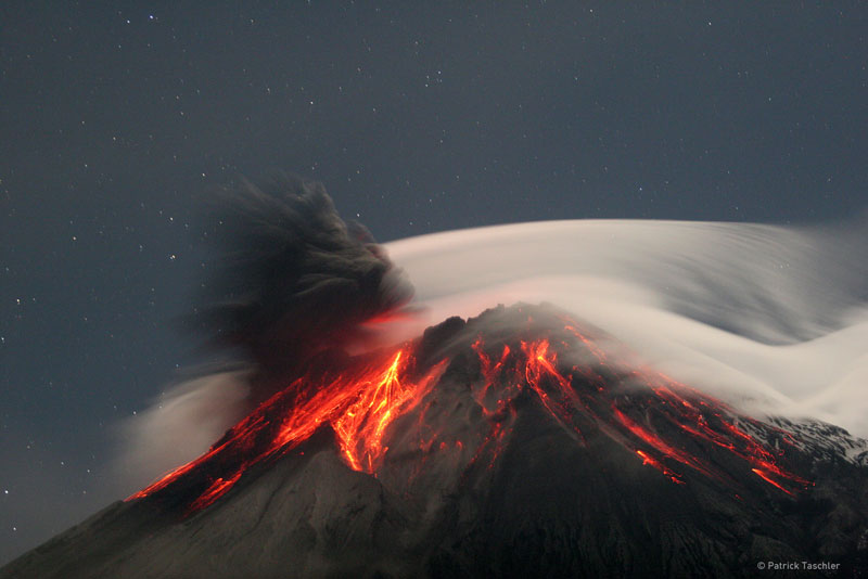
Tungurahua Erupts Credit & Copyright: PatrickTaschler
Explanation: Volcano Tungurahua erupted spectacularly last year. Pictured above, molten rock so hot it glows visibly pours down the sides of the 5,000-meter high Tungurahua, while a cloud of dark ash is seen being ejected toward the left. Wispy white clouds flow around the lava-lit peak, while a star-lit sky shines in the distance. The above image was captured last year as ash fell around the adventurous photographer. Located in Ecuador, Tungurahua has become active roughly every 90 years since for the last 1,300 years. Volcano Tungurahua has started erupting again this year and continues erupting at a lower level even today.
Click thumbnail for larger image
More information:
Tungurahua, Ecuador
Location: 1.467 S, 78.44 W
Elevation: 16,475 ft. (5023 m)
Tungurahua is an active stratovolcano also known as the “The Black Giant.” It has a 600 ft. (183 m) wide crater. Most of the volcano is covered by snow. It causes many tremors in the nearby city of Banos. Tungurahua’s lava is mostly composed of basalts. Tungurahua has had at least seventeen eruptions in historical times, its most recent occurring in 1944 when it erupted explosively from its central crater. Located about 25 miles (~40 km) west of Tungurahua is the largest volcano in Equador, Chimborazo and to the north about 50 miles(~80 km ) is Cotopaxi volcano.
Spread the word; friends don't allow friends to repeat history.
Editor’s note: Dr. Vincent Resh of the University of California at Berkeley addressed the distinguished, long-lived Commonwealth Club of San Francisco on August 22, 2007. Below is a column by Resh which appeared in the San Francisco Chronicle a few days before the speech, covering much of the same material.
Resh tells the story of a public health victory in Africa against a disease called river blindness. People victimized are made blind by a parasitic worm which lives in the victim’s eyes. I relate it here because Resh tells how the victory is achieved without resorting to the use of destructive DDT, which had been proposed. Note carefully what Resh says about DDT. This is one more chunk of evidence against the broadcast use of DDT, a story in support of the ban on DDT imposed in the U.S. since 1972. Rachel Carson was right. _____________________
Vincent H. Resh has been a professor of entomology at UC Berkeley since 1975. He was the senior environmental adviser for the onchocerciasis control program.
Insect-transmitted diseases typically come to our attention through local news reports of the threat of West Nile virus or of dengue fever in our neighborhoods. The works of the Gates Foundation have made us more aware of malaria, the mosquito-transmitted disease that kills well more than a million people each year. But there are scores of insect-transmitted diseases that affect humans, and the insects responsible for many of them live in water.
DDT and its descendents were initially effective in controlling the water-dwelling vectors of human diseases. However, the effects of these insecticides on environmental health also had significant, indirect effects on human health. The fish in rivers, which are the main protein source for humans in most developing countries, were drastically reduced by these poisons.
The prairie is one of North America’s great ecosystems and a vital habitat for many plants and animals. Over 98% of the prairie has been lost in the past 150 years—but some people are trying to bring it back, hectare by hectare. Restoring a prairie is a great challenge, requiring knowledge of biology, ecology, climatology, and even economics.
Are you up for the challenge? If you choose the right plants and animals, you can watch the prairie come to life before your eyes! Let’s begin!
North America’s prairie is divided into the tallgrass ecosystem and shortgrass ecosystem (plus an area in between—the “mixed grass” prairie). Which one do you want to restore?
This game fits neatly into geography curricula for a number of states, and also covers parts of the 7th grade social studies standards for Texas — if your state is covered by the tallgrass or shortgrass prairies as shown on the accompanying map, it’s likely your state standards include students’ learning about prairie ecosystems.
The game is fail-safe; it does not allow incorrect selections. It’s not a sim, really, but a basic introduction to what makes a successful prairie. Students should be able to master the game in 15 minutes.
Though developed way up north in Minnesota, the game and species are close to Texas prairies, too. The emphasis on soil points to some of the key errors made by farmers (encouraged by developers and the U.S. Department of Agriculture) which led to the Dust Bowl; this is a good enrichment exercise for Dust Bowl lesson plans. These games cover many of the requirements for Boy Scout merit badges, too: Environmental Science, Wildlife Management, and Soil and Water Conservation, and others.
Update, October 2011: No, I can’t find the game now, either. It appears the Bell Museum took the site down, and trusting (and hoping) they wouldn’t do that, I didn’t pirate any of the images, nor especially the game.
Here’s hoping someone will put the thing back on line, somewhere. If you find it, will you let me know? I’d like to renew the links. Several school systems went through this site to get to the game for classroom activities. It was a good thing.
It’s headed up by a bunch from downunder. U.S., Canadian and Mexican bloggers haven’t got on the bandwagon a lot, yet. As the organizers describe it:
On October 15th – Blog Action Day, bloggers around the web will unite to put a single important issue on everyone’s mind.
In its inaugural year, Blog Action Day will be co-ordinating bloggers to tackle the issue of the environment.
What Each Blogger Will Do
Bloggers can participate on Blog Action Day in one of two ways:
Publish a post on their blog which relates to an issue of their own choice pertaining to the environment.For example: A blog about money might write about how to save around the home by using environmentally friendly ideas. Similarly a blog about politics might examine what weight environmental policy holds in the political arena.Posts do not need to have any specific agenda, they simply need to relate to the larger issue in whatever way suits the blogger and readership. Our aim is not to promote one particular viewpoint, only to push the issue to the table for discussion.
Commit to donating their day’s advertising earnings to an environmental charity of their choice. There is a list of “official” Blog Action Day charities on the site, however bloggers are also free to choose an alternate environmental charity to donate to if they wish.
And that’s it.
A gentle nudge to a better planet. Seems like a good idea to me.
Irony sometimes means happy surprises. Cuneiform on the world wide web?
The University of California system is working hard to deliver important information to scholars on the web. One of these projects is the Cuneiform Digital Library Initiative (CDLI). Here is the official desription:
The Cuneiform Digital Library Initiative (CDLI) represents the efforts of an international group of Assyriologists, museum curators and historians of science to make available through the internet the form and content of cuneiform tablets dating from the beginning of writing, ca. 3350 BC, until the end of the pre-Christian era. We estimate the number of these documents currently kept in public and private collections to exceed 500,000 exemplars, of which now more than 200,000 have been catalogued in electronic form by the CDLI.
Some of the photos demonstrate the beauty of everyday history and archaeology. These are instructional photos, but some are works of art. Examples of drawings of the writing are available, which can be used in the classroom to show students what the writing looks like.
Some sites in CDLI allow searches by topic. Students, consider these school tablets, and thank your lucky stars, inventors and the trees for paper and ink. Can you imagine lugging these things in a backpack?
Strange Maps features odd maps, often fictional. I like the site, especially for the inherent humor in some of the maps — and since it’s such a popular site among the more than 1 million WordPress weblogs, it’s clear others share my enthusiasm.
There are a lot of unstrange and beautiful maps based on reality, too, used to give a quick, graphic image to the brains of people working on serious problems. Maps guide policy makers, and illustrate geographical range of problems, and sometimes geographical causes and vulnerabilities.
Maps at this site cover a nearly complete range of issues that worry leaders of businesses and nations. I found the site looking for information about malaria.
Of special note is the wealth of information available from the interactive features. Clicking on nations or on symbols on the map provides details of issues the map covers; three tabs with the maps take the viewer of most of the maps to an extensive list of resources on the issue, and case studies, and analysis. These sources seem tailor made to help students doing geography projects.
Issue maps include disasters, malaria, child labor, climate change, poverty, land mine risk, political risk and a wide variety of others. You’ll need Macromedia Flash on your computer; there does not appear to be any way to download the maps, so you’ll need a live internet link to use these in class.
Information from these maps will be more current than any geography, history or economics book. Go see.
Maplecroft is a network of academic and business consultants. These maps are made to help their clients; Maplecroft’s description of the series is below the fold.
Bug Girl has all the details — spiders being closer to her blog’s core topic — but this news is just about 90 minutes from here, much closer for North Dallasites.
“At first, it was so white it looked like fairyland,” said Donna Garde, superintendent of the [Lake Tawakoni State] park about 45 miles east of Dallas. “Now it’s filled with so many mosquitoes that it’s turned a little brown. There are times you can literally hear the screech of millions of mosquitoes caught in those webs.”
Ah, the screech of millions of mosquitoes, about to be eaten.
3. China’s ascent in world position brings responsibilities it may have hoped to avoid, such as protecting the environment. Ending the encroachment of the desert in this case is a tall order — but if it can be done there, perhaps it can also be done around the Sahara, around the Namib, around the Syrian Desert, and other places where grasses once grew, but dust now blows. These sites are more common than one might think.
Tip of the old scrub brush to Jonathan Turley’s new blog — Turley’s a good lawyer with very interesting cases; his views are a welcome addition. Most of his blog simply points to interesting legal issues.
Spread the word; friends don't allow friends to repeat history.
Dean was officially the most powerful hurricane that we’ve seen globally so far in 2007, and was by far the strongest at landfall. It was also the first Category 5 Atlantic hurricane seen since the record-setting Hurricane Wilma of October 2005. In fact, Dean set some records of its own. Its pressure was the ninth lowest ever measured in the Atlantic, and the third lowest at landfall. Indeed, there hasn’t been a full Category 5 landfall in our part of the world since 1992’s Hurricane Andrew. Dean was in all respects a terrifying storm, and we can only hope that the damage will somehow be less than expected as it tears across the peninsula and then, after crossing the Bay of Campeche, moves on to a presumed second Mexican landfall.
1. Dean is the ninth most intense Atlantic storm by pressure, and six of the top ten (Wilma, Rita, Katrina, Mitch, Dean, and Ivan) have occurred in the past ten years.
2. Dean is the strongest hurricane anywhere this year, and by far the strongest at landfall. It is the tenth category 4 or 5 hurricane globally and the 3rd Category 5.
Texas has mobilized disaster relief efforts as never before. School buses have been mustered near San Antonio for evacuations. 90,000 gallons of gasoline have been delivered to potential hurricane zones, to aid in self-evacuations. Helicopters are being mustered just outside potential storm zones. Someone is paying attention to the damage mitigation and clean up.
Spread the word; friends don't allow friends to repeat history.
It’s been about a week since some global warming skeptic pointed me toward a recent piece from Freemon Dyson, claiming that if Dyson didn’t believe in global warming, no one should. Tip of the old scrub brush to whoever that skeptic was.
I read Dyson’s piece, and while he’s cranky, he’s not denying global warming. A good chunk of his piece discusses how to capture carbon dioxide to prevent further warming, or perhaps even reverse current atmospheric trends. Skeptics of warming who seize on Dyson’s piece as a rebuttal make a common error among the scentifically unquestioning ranters: They assume any criticism of part of an argument is a refutation of the whole. Dyson suggests we should spend time and money on figuring out how to get the microbiota in the soil to capture more CO2.
Much of the rest of the piece is hopeful. Dyson disagrees with hysteric concerns about melting glaciers; he doesn’t think they’ll all melt or cause dramatic rises in sea level. At the same time, he urges caution and study, noting the holes in our knowledge that most arm-chair global warming skeptics want to ignore, including the possibilities that global warming itself would trigger a dramatic shift to a new ice age, which would be at least as catastrophic.
We can separate the climate cranks from the true skeptics if we look for similar flights of reality from people: The true skeptics will note how difficult it is to predict climate and weather, but do not deny the need to act against pollutants which are thought to cause climate change. This is a crucial difference. Bush administration officials originally denied the existence of global warming as an excuse to do nothing about air pollution; now they claim to recognized global warming, but still do little that might control human dumping into the air. In sharp contrast, Dyson proposes a partly-neglected sink of CO2 and urges that we work hard to increase its effectiveness.
In the past year I have posed that question in several climate discussions: Do you oppose controlling air pollution? The question quickly separates cranks from others; while the scientifically literate may argue about whether we can predict human effects on weather, few argue that we should continue our present trends of dumping.
Or, until that account is unsuspended by the forces supporting Donald Trump: Follow @FillmoreWhite, the account of the Millard Fillmore White House Library
We've been soaking in the Bathtub for several months, long enough that some of the links we've used have gone to the Great Internet in the Sky.
If you find a dead link, please leave a comment to that post, and tell us what link has expired.
Thanks!
Retired teacher of law, economics, history, AP government, psychology and science. Former speechwriter, press guy and legislative aide in U.S. Senate. Former Department of Education. Former airline real estate, telecom towers, Big 6 (that old!) consultant. Lab and field research in air pollution control.
My blog, Millard Fillmore's Bathtub, is a continuing experiment to test how to use blogs to improve and speed up learning processes for students, perhaps by making some of the courses actually interesting. It is a blog for teachers, to see if we can use blogs. It is for people interested in social studies and social studies education, to see if we can learn to get it right. It's a blog for science fans, to promote good science and good science policy. It's a blog for people interested in good government and how to achieve it.
BS in Mass Communication, University of Utah
Graduate study in Rhetoric and Speech Communication, University of Arizona
JD from the National Law Center, George Washington University


 Posted by Ed Darrell


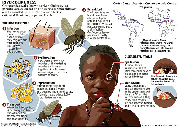 Click on thumbnail image for a chart showing the life cycle of river blindness


