August 24, 79 C.E.: Vesuvius spoke, with thunder

August 24, 2015

Much as the GOP Caucus and other climate-change deniers, Roman officials in Pompeii and Herculaneum refused to be alarmed at the ground shaking, and obvious eruptions from Mount Vesuvius, on August 24, 79 C.E.

In the past week we have earthquakes in California, Nepal, British Columbia, and other places. The old Earth keeps rumbling.

Oddly, we now pay more attention to earthquakes than to other things that can cause greater, rolling disasters.

Santayana’s Ghost wonders if we ever learn from history.

Vesuvius, asleep for now. National Geographic photo by Robert Clark

Vesuvius, asleep for now (2013). National Geographic photo by Robert Clark

More:

Yes, this is mostly an encore post. Fighting ignorance requires patience.

Yes, this is mostly an encore post. Fighting ignorance requires patience.


Texas earthquakes, 2014

January 7, 2015

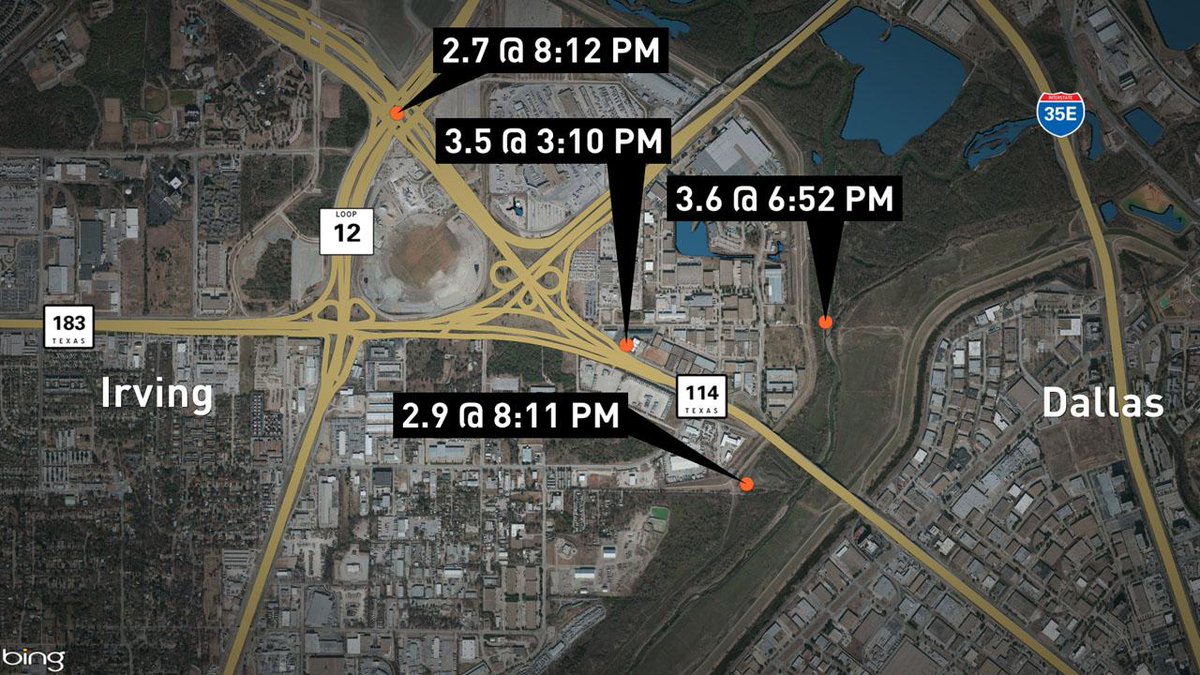
WFAA Channel 8 map of four quakes confirmed by 10:00 p.m. news casts, showing how close the quakes are in proximity to each other and the site of the old Cowboys Football Stadium.

WFAA Channel 8 map of four quakes confirmed by 10:00 p.m. news casts, showing how close the quakes are in proximity to each other and the site of the old Cowboys Football Stadium.

This Tweet from our local NBC TV affiliate sums it up nicely.

North Texas shook yesterday — not big quakes, but a bunch of ’em — and that doesn’t sit well with Texas oil executives, since it seems likely gas and oil drilling, especially hydraulic fracturing (fracking), and especially waste-water reinjection seem to be causes.

I grew up in Utah.  We had quakes you could feel, at least weekly.  Our home sat less than a mile west of the Wasatch Fault.  Many mornings my mother would stand drinking her coffee, looking over the stove and out our kitchen window at Mt. Timpanogos, remarking on the earthquakes.  Most often we couldn’t feel them, but the power and telephone lines that slashed through our $10 million view of the mountain would dance in sine waves during quakes. It was pretty cool.

Along the more famous faults, one rarely comes on more than a couple of quakes a day.

Dallas — more accurately, Irving — is far away from most major faults, and rarely has more than a couple of quakes a year in recent human history.

So this swarm of quakes makes news!

WTVT Channel 11 (CBS) reported:

DALLAS (CBSDFW.COM/AP) – Nine earthquakes, three of them with a 3-point magnitude or greater, rocked North Texas Tuesday into early Wednesday, knocking items off walls, causing cracks to appear in ceilings and generally rattling nerves across the region.

“The last one really shook,” said CBS 11 anchor and reporter Ken Molestina, who felt the the earth move in the White Rock Lake area of Dallas.

The latest quake, reported just before 1 a.m. Wednesday, measured in at a 3.1 magnitude, and was centered near the convergence of State Highway 114, Loop 12, and the Airport Freeway near the old Texas Stadium site in Irving.

Others felt the temblor in the Uptown area of Dallas and as far away as Bedford and Mesquite.

Here’s a list of the quakes in order of when they happened:

7:37 a.m.                    2.3 magnitude

3:10 p.m.                    3.5 magnitude

6:52 p.m.                    3.6 magnitude

8:11 p.m.                    2.9 magnitude

8:12 p.m.                    2.7 magnitude

9:54 p.m.                    1.7 magnitude

10:05 p.m.                  2.4 magnitude

11:02 PM                   1.6 magnitude

12:59 AM                   3.1 magnitude

Rafael Abreu, a geophysicist with the USGS, spoke with NewsRadio 1080 KRLD and said while the Irving earthquakes happened only hours apart, given the strength and intensity, “we’re not calling it an aftershock.”

At last count Tuesday night, there had been 24 or more earthquakes in the Irving area since November 1, 2014.

Jokes fly, too.  Not this much shaking since Elvis toured the area heavily in 1957, some say.

Screen capture of USGS reports of four earthquakes in or near Irving, Texas, on January 6, 2014

Screen capture of USGS reports of four earthquakes in or near Irving, Texas, on January 6, 2014

Recent studies show earthquakes in other areas linked to oil and gas drilling and extraction.  All of these quakes are in close proximity to working wells or wells being drilled.

What’s the Earth trying to tell us?

Details from USGS on biggest quake, January 6, 2014

Details from USGS on biggest quake, January 6, 2014

More:

Historically, Texas has not been a hotbed of earthquake activity, between 1973 and 2012.  Texas Seismicity Map from USGS.

Texas Seismicity, 1973-2012. USGS


August 24, 79 C.E.: Vesuvius had something to say

August 24, 2014

Much as the GOP Caucus and other climate-change deniers, Roman officials in Pompeii and Herculaneum refused to be alarmed at the ground shaking, and obvious eruptions from Mount Vesuvius, on August 24, 79 C.E.

This morning we awake to news of earthquakes in Chile and California. The old Earth keeps rumbling.

Oddly, we now pay more attention to earthquakes than to other things that can cause greater, rolling disasters.

Santayana’s Ghost wonders if we ever learn from history.

Vesuvius, asleep for now. National Geographic photo by Robert Clark

Vesuvius, asleep for now. National Geographic photo by Robert Clark


Oklahoma earthquake swarm, November 2011?

November 6, 2011

Is it enough to call it a swarm?  Oklahoma hadn’t had a quake of great signficance in about 30 years, but they had a 5.6 and a 4.7  yesterday — and look at this list for today and yesterday from the USGS (list will probably change at USGS as time moves on):

MAG UTC DATE-TIME
y/m/d h:m:s
LAT
deg
LON
deg
DEPTH
km
LOCATION
MAP 3.3 2011/11/06 18:26:56 35.478 -96.864 5.0 4 km ( 2 mi) SE of Meeker, OK
MAP 3.7 2011/11/06 17:52:34 35.547 -96.819 5.0 7 km ( 4 mi) S of Sparks, OK
MAP 3.9 2011/11/06 15:07:05 35.535 -96.909 5.0 4 km ( 3 mi) NNW of Meeker, OK
MAP 3.2 2011/11/06 11:20:23 35.525 -96.883 5.0 3 km ( 2 mi) NNE of Meeker, OK
MAP 3.0 2011/11/06 11:16:20 35.523 -96.844 4.9 6 km ( 3 mi) ENE of Meeker, OK
MAP 3.4 2011/11/06 11:03:52 35.539 -96.825 5.0 8 km ( 5 mi) S of Sparks, OK
MAP 3.9 2011/11/06 10:52:35 35.567 -96.797 5.0 5 km ( 3 mi) SSE of Sparks, OK
MAP 4.0 2011/11/06 09:39:57 35.506 -96.865 5.0 3 km ( 2 mi) ENE of Meeker, OK
MAP 3.4 2011/11/06 09:22:04 35.585 -96.823 5.0 3 km ( 2 mi) S of Sparks, OK
MAP 2.7 2011/11/06 08:14:12 35.474 -96.794 5.0 7 km ( 4 mi) NNE of Johnson, OK
MAP 3.2 2011/11/06 07:32:40 35.544 -96.901 4.9 5 km ( 3 mi) N of Meeker, OK
MAP 3.8 2011/11/06 06:31:10 35.559 -96.874 5.0 7 km ( 4 mi) NNE of Meeker, OK
MAP 3.0 2011/11/06 04:54:00 35.540 -96.687 5.0 6 km ( 4 mi) N of Prague, OK
MAP 3.6 2011/11/06 04:03:41 35.554 -96.760 5.0 8 km ( 5 mi) SE of Sparks, OK
MAP 5.6 2011/11/06 03:53:10 35.537 -96.747 5.0 8 km ( 5 mi) NW of Prague, OK
MAP 3.6 2011/11/05 14:36:30 35.584 -96.789 4.9 4 km ( 2 mi) SE of Sparks, OK
MAP 3.4 2011/11/05 13:42:26 35.530 -96.766 5.0 9 km ( 5 mi) NW of Prague, OK
MAP 3.3 2011/11/05 11:24:15 35.521 -96.778 5.0 9 km ( 6 mi) WNW of Prague, OK
MAP 3.3 2011/11/05 09:12:11 35.591 -96.788 4.9 4 km ( 2 mi) SE of Sparks, OK
MAP 2.7 2011/11/05 07:50:42 35.559 -96.762 4.8 8 km ( 5 mi) SE of Sparks, OK
MAP 2.7 2011/11/05 07:44:34 35.488 -96.755 5.0 6 km ( 4 mi) W of Prague, OK
MAP 3.4 2011/11/05 07:27:20 35.566 -96.698 5.0 9 km ( 6 mi) N of Prague, OK
MAP 4.7 2011/11/05 07:12:45 35.553 -96.748 4.0 9 km ( 6 mi) SE of Sparks, OK

Back to Map Centered at 36°N, 96°W (That’s Tulsa, roughly)


23 quakes in two days.  Oklahomans might be excused for wondering what’s up.

Just technical details here.  USGS issued a notice on both of the larger quakes, the 4.7 on Saturday, November 5, and the 5.6 on Sunday, November 6.

Still, this isn’t much of a swarm for an active quake zone, like California, or Yellowstone, or Alaska.

But, for Oklahoma, this is big.  Plus, it appears to lay observers that earthquake intensity and frequency both have been building for over a year.   Recent earthquakes in Arkansas and Texas concern some local residents who fear the quakes are the result of hydrofracturing (fracking) activities being conducted in relation to natural gas and oil drilling and extraction.

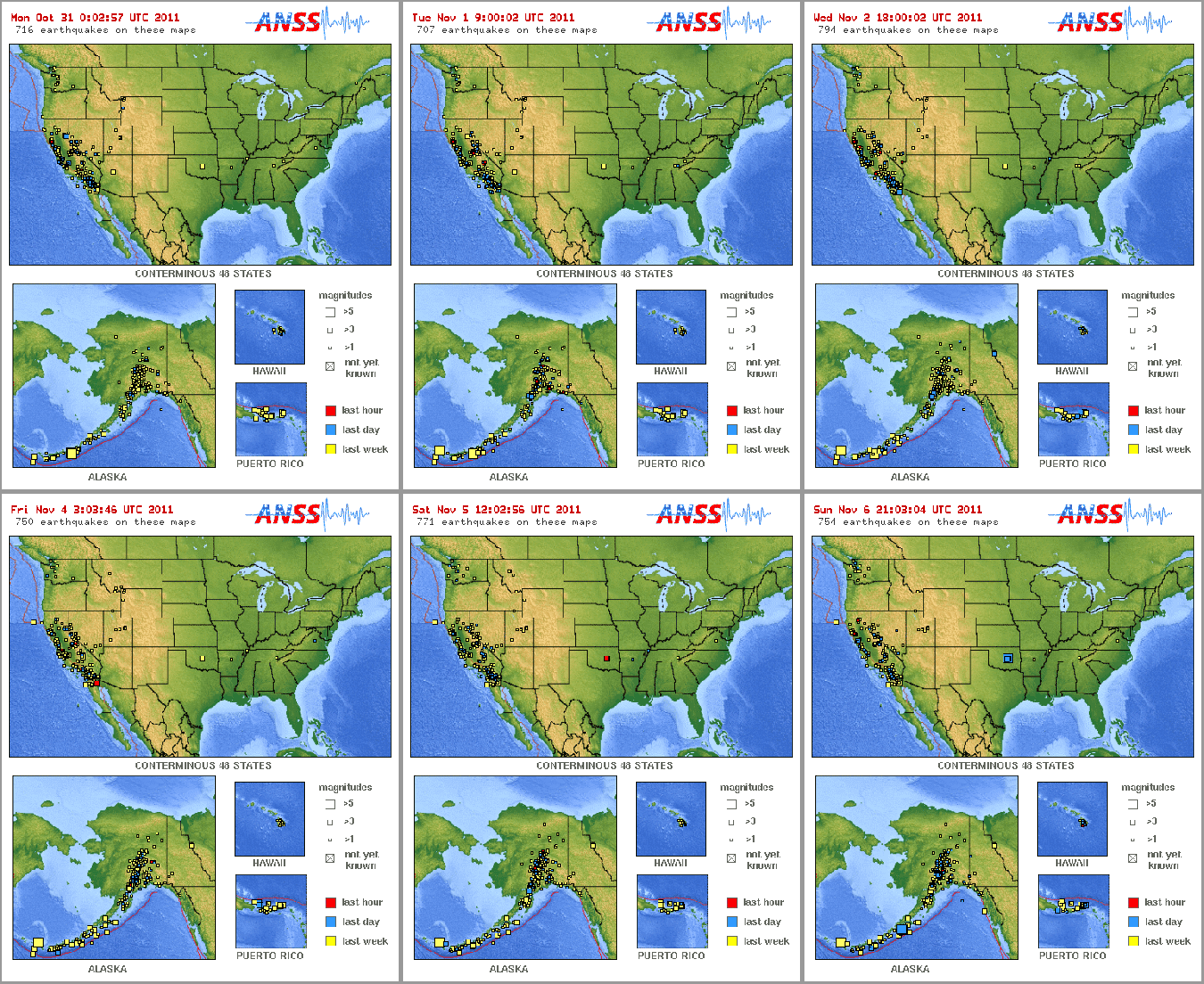
And as this map of U.S. quakes in the preceding week shows, the quakes in Oklahoma are the largest in the U.S. for the week.

USGS animation of quakes in US for week ending Nov 6, 2011, afternoon

More quakes in California, on the USGS maps -- but the Oklahoma quakes are biggest

Research continues, and local residents stay nervous.

Here’s a map that should update with new quake information — which means, Oklahomans hope, that the indicators of quakes will go away over the next few days.

USGS map of Oklahoma City/Tulsa area where earthquakes occurred in the week leading up to November 6, 2011

USGS map of Oklahoma City/Tulsa area where earthquakes occurred in the week leading up to November 6, 2011


Laden’s late; but, is Yellowstone gonna blow AND TAKE US WITH IT?

February 26, 2011

The veteran reader of this blog — can there be more than one? — may recall the kerfuffle a couple of years ago when there was a “swarm” of earthquakes in the Yellowstone.  Alas for those prone to panic attacks, the swarm ran through the Hanukkah/Ramadan/Christmas/KWANZAA/New Year’s holidays, when other news is slack.

Yellowstone Caldera, Smith and Siegel 2000

What the Yellowstone Caldera might look like from space, by moonlight, on a clear night, if you can imagine the borders of Yellowstone National Park very vividly – Smith and Siegel, 2000

You might understand, then, why I say Greg Laden turns his considerable story-telling prowess to the issue late.  Still, his prowess towers over the rest of us, and he tells a great story.

Is the Yellowstone safe? he asks, rhetorically.

The answer is complex:

1) Wear a seat belt when driving around in the region;

2) Don’t feed the bears and make sure you understand bear safety; and

3) Somebody is going to get blasted by some kind of volcano in the area some day, but even if you live there the chances are it won’t be you.

The joy is in the journey — go read Laden’s explanation of the rising lava.  Heck, even those of us who think we know that stuff understand it better when he explains it.

Earlier in the Bathtub:

Also see:


Okalahoma earthquakes: No swarm

March 6, 2010

Three earthquakes in a week do not make a swarm.  Interesting that the last post on an earthquake in Oklahoma drew earthquake conspiratorialists and “skeptics.”  Too many people distrust all science and sources of information these days.

Here’s the dirt on Oklahoma’s shaking in the last week, from the U.S. Geological Service site:

Earthquake List for Map Centered at 36°N, 97°W

Update time = Sat Mar 6 18:00:02 UTC 2010

Here are the earthquakes in the Map Centered at 36°N, 97°W area, most recent at the top.
(Some early events may be obscured by later ones.)
Click on the underlined portion of an earthquake record in the list below for more information.

MAG UTC DATE-TIME
y/m/d h:m:s
LAT
deg
LON
deg
DEPTH
km
LOCATION
MAP 3.1 2010/03/05 20:35:13 35.608 -96.783 5.0 3 km ( 2 mi) E of Sparks, OK
MAP 2.5 2010/03/03 04:35:17 35.549 -97.282 5.0 2 km ( 1 mi) SSE of Jones, OK
MAP 4.1 2010/02/27 22:22:27 35.557 -96.747 3.3 9 km ( 5 mi) SE of Sparks, OK

This isn’t unusual at all, of course. I think many people just don’t understand that earthquakes happen all the time, but they usually get crowded out of the newspaper because no one really cares.

For contrast, take a look at this animated map of a strip a little wider than Utah, covering from north of the Yellowstone Caldera to Arizona.  Run the animation.  Generally on any day there will have been at least two dozen earthquakes in the previous week, several magnitude 3, occasionally a magnitude 4 thrown in.

Almost none of those quakes make any news.

Maybe it’s the Earth, laughing.  We can hope.

Laugh, and the world laughs with you;
Weep, and you weep alone.
For the sad old earth must borrow it’s mirth,
But has trouble enough of its own.
Sing, and the hills will answer;
Sigh, it is lost on the air.
The echoes bound to a joyful sound,
But shrink from voicing care.

(Excerpted from “Solitude,” 1917, by Ella Wheeler Wilcox (1850-1919))


Shakiest states — geologically, that is

March 4, 2010

USGS map of states with the most quakes

Quake rankings of states

Which states shake the most?  Here are the top 20.

Surprised that Maine makes the list?

Much more from the US Geological Survey here, “Top Earthquake States.”


Tsunami warnings for Hawaii: How science really works

February 27, 2010

As I write this it’s more than five hours away.

Earthquake map from USGS, showing location of the Chile quake 2-27-2010

Earthquake map from USGS, showing location of the Chile quake 2-27-2010 - click on map to go to interactive version at USGS site

A horrible, devastating earthquake hit Chile last night, on the west coast of South America.  Scientists at the Pacific Tsunami Warning Center fear it may have triggered a tsunami that will hit Hawaii today (an AP story says at 5:19 p.m. Eastern; that’s 4:19 p.m. Central, and just after 11:00 a.m. in Honolulu, Hawaii, Hawaiian-Aleutian Standard Time (HAST).

HONOLULU (Reuters) – Hawaii prepared to start evacuations ahead of a tsunami generated by a massive earthquake in Chile, a civil defense official on the U.S. island said on Saturday.

It planned to sound civil defense sirens across the island state at 6 a.m. local time (11 a.m. EST) after the Pacific Tsunami Warning Center said a tsunami was generated that could cause damage along the coasts of all the Hawaiian islands,

“Get off the shore line. We are closing all the beaches and telling people to drive out of the area,” said John Cummings, Oahu Civil Defense spokesman.

Buses will patrol beaches and take people to parks in a voluntary process expected to last five hours.

More than an hour before sirens were due to sound lines of cars snaked for blocks from gas stations in Honolulu.

“Urgent action should be taken to protect lives and property,” the Warning Center said in a bulletin. “All shores are at risk no matter which direction they face.”

*  *  *  *  *  *  *  *

The warning follows a huge earthquake in Chile that killed at least 82 people and triggered tsunamis up and down the coast of the earthquake-prone country.

The center estimates the first tsunami, which is a series of several waves in succession, will hit Hawaii at 11:19 a.m. Hawaii time (4:19 p.m. EST) in the town of Hilo on the Big Island of Hawaii, with waves in Honolulu at 11:52 a.m.

Sardina said the Hawaiian islands could expect waves of six feet (two meters) in some places. Other estimates have been higher but he could not confirm those were likely.

Plate tectonics at work — the Pacific plate pushing underneath South America.  The epicenter was 22 miles deep.  We get a glimpse into how geologists and others work with a report from the Times of London:

Several big aftershocks later hit the south-central region, including ones measuring 6.9, 6.2 and 5.6.

The earthquake was caused by the floor of the Pacific being pushed below South American land mass.

This sudden jerking of the sea-floor displaced water and triggered a tsunami, which is now crossing the ocean at a speed of a jet plane.

The Pacific Tsunami Warning Center issued a warning for Chile and Peru, and a less-urgent tsunami watch for Ecuador, Colombia, Panama, Costa Rica and Antarctica.

A spokesman said: “Sea level readings indicate a tsunami was generated.

Will a potential disaster in human lives be averted?

Isn’t this exactly how science is supposed to work?  Will the anti-science yahoos ignore the warnings?

Woo notice: Our dogs were restless last night.  I had to get up twice to let them out just to bark with the rest of the dogs in the neighborhood, who all seemed to be going nuts at once.  Looking at the news stories, it was just a bit before the big quake hit Chile.  It doesn’t make sense to me that dogs so far away from the epicenter would be affected that way.

Resources:

Hawaii map and threat map from the Pacific Tsunami Warning Center - 2-27-2010

Hawaii map and threat map from the Pacific Tsunami Warning Center, February 27, 2010. Click on image for current information.


Yellowstone Earthquake Swarm of 2010 fizzling out?

January 27, 2010

Inside Yellowstone noted just three earthquakes in the Yellowstone swarm in a 24-hour period covering most of Saturday.

It wasn’t the End of the World as Old Faithful Knows It, after all.

The Yellowstone Volcano Observatory (YVO) suggests the swarm continues, however — but doesn’t suggest anyone should be too concerned about it.

As of January 26, 2010 9:00 AM MST there have been 1,360 located earthquakes in the recent Yellowstone National Park swarm. The swarm began January 17, 2010 around 1:00 PM MST about 10 miles (16 km) northwest of the Old Faithful area on the northwestern edge of Yellowstone Caldera. Swarms have occurred in this area several times over the past two decades.

There have been 11 events with a magnitude larger than 3, 101 events of magnitude 2 to 3, and 1248 events with a magnitude less than 2. The largest events so far have been a pair of earthquakes of magnitude 3.7 and 3.8 that occurred after 11 PM MST on January 20, 2010.

The first event of magnitude 3.7 occurred at 11:01 PM MST and was shortly followed by a magnitude 3.8 event at 11:16 PM. Both shocks were located around 9 miles to the southeast of West Yellowstone, MT and about 10 miles to the northwest of Old Faithful, WY. Both events were felt throughout the park and in surrounding communities in Wyoming, Montana, and Idaho.

See the University of Utah Seismograph Stations for the most recent earthquake data and press releases. The team is working 24/7 to analyze and communicate information about the swarm. Seismograph recordings from stations of the Yellowstone seismograph network can be viewed online at: http://quake.utah.edu/helicorder/yell_webi.htm.

You can get the information from the horse’s mouth (Dragon’s Mouth?) — some enterprising earth sciences, geography or general science teacher can probably work up a great assignment for students to deal with the data and make sense from them.

Ground deformations in the Yellowstone Caldera, from satellite photos - Geology.com imageGround deformations in the Yellowstone Caldera, from satellite photos - Geology.com image

Ground deformations in the Yellowstone Caldera, from satellite photos, in 2005 - Geology.com image (This isn't really directly related to the earthquake swarm, but it's a cool image.)

Update, March 12, 2011: This post has been mighty popular over the last week.  Can someone tell me, in comments, whether this post was linked to by another site?  Why the popularity all of a sudden — even before the Japan earthquake and tsunami?  Please do!


Yellowstone earthquake swarm, 2010

January 25, 2010

Stop me if you’ve heard this one:

Earthquake swarm hits the area of the Yellowstone Caldera, around Yellowstone Park; wackoes start predicting the End of the World As We Know It, at least for West Yellowstone, Montana, and Jackson Hole, Wyoming.  Unless they are Bobby Jindal, and they predict that the quakes didn’t even happen.

Oh, yeah — that was the series of earthquake swarms in late 2008 and early 2009, right?

Not exactly.  It’s happened again.

Yellowstone Volcano Observatory logo
YELLOWSTONE VOLCANO OBSERVATORY INFORMATION STATEMENT
Thursday, January 21, 2010 2:26 PM MST (Thursday, January 21, 2010 2126 UTC)

Yellowstone Volcano
44°25’48” N 110°40’12” W, Summit Elevation 9203 ft (2805 m)
Current Volcano Alert Level: NORMAL
Current Aviation Color Code: GREEN

The earthquake swarm on the northwest edge of Yellowstone Caldera that began on January 17, 2010 continues.

PRESS RELEASE FROM YVO PARTNER UNIVERSITY OF UTAH SEISMOGRAPH STATIONS

Released: January 21, 2010 2:00PM MST

This release is a continuation of information updates building upon our two previous press releases on the ongoing earthquake swarm on the west side of Yellowstone National Park. The University of Utah Seismograph Stations reports that a pair of earthquakes of magnitude 3.7 and 3.8 occurred in the evening of January 20, 2010 in Yellowstone National Park.

The first event of magnitude 3.7 occurred at 11:01 PM and was shortly followed by a magnitude 3.8 event at 11:16 PM. Both shocks were located around 9 miles to the southeast of West Yellowstone, MT and about 10 miles to the northwest of Old Faithful, WY. Both events were felt throughout the park and in surrounding communities in Wyoming, Montana, and Idaho.

These two earthquakes are part of an ongoing swarm in Yellowstone National Park that began January 17, 2010 (1:00 PM MST). The largest earthquake in the swarm as of 12 PM, January 21, 2010, was a magnitude 3.8. There have been 901 located earthquakes in the swarm of magnitude 0.5 to 3.8. This includes 8 events of magnitude larger than 3, with 68 events of magnitude 2 to 3, and 825 events of magnitude less than 2. There have been multiple personal reports of ground shaking from observations inside the Park and in surrounding areas for some of the larger events (for felt reports, please visit http://earthquake.usgs.gov/eqcenter/dyfi/). Earthquake swarms are relatively common in Yellowstone.

The swarm earthquakes are likely the result of slip on pre-existing faults rather than underground movement of magma. Currently there is no indication of premonitory volcanic or hydrothermal activity, but ongoing observations and analyses will continue to evaluate these different sources.

Seismic information on the earthquake can be viewed at the University of Utah Seismograph Stations: http://www.seis.utah.edu/.

Seismograph recordings from stations of the Yellowstone seismograph network can be viewed online at: http://quake.utah.edu/helicorder/yell_webi.htm.

Anyone who has felt earthquakes in the swarm are encouraged to fill out a form on the USGS Community Felt reports web site: http://earthquake.usgs.gov/eqcenter/dyfi/.

This press release was prepared by the Yellowstone Volcano Observatory partners of the U.S. Geological Survey, the University of Utah, and the National Park Service: http://volcanoes.usgs.gov/yvo/

The Yellowstone Volcano Observatory (YVO) is a partnership of the U.S. Geological Survey (USGS), Yellowstone National Park, and University of Utah to strengthen the long-term monitoring of volcanic and earthquake unrest in the Yellowstone National Park region. Yellowstone is the site of the largest and most diverse collection of natural thermal features in the world and the first National Park. YVO is one of the five USGS Volcano Observatories that monitor volcanoes within the United States for science and public safety.

CONTACT INFORMATION:
Peter Cervelli, Acting Scientist-in-Charge, USGS

pcervelli@usgs.gov (650) 329-5188


The Yellowstone Volcano Observatory (YVO) was created as a partnership among the U.S. Geological Survey (USGS), Yellowstone National Park, and University of Utah to strengthen the long-term monitoring of volcanic and earthquake unrest in the Yellowstone National Park region. Yellowstone is the site of the largest and most diverse collection of natural thermal features in the world and the first National Park. YVO is one of the five USGS Volcano Observatories that monitor volcanoes within the United States for science and public safety.

Here’s the map as of Sunday night, January 24, 9:10 p.m. MST (where the observatory is located); while this map may update here, you may want to click over to the observatory for more information (click on the map):

Yellowstone National Park Special Map, showing earthquakes in last week.

Yellowstone National Park Special Map, showing earthquakes in last week.

Eruptions has a short post on the swarmVolcanism, which covers volcanoes better than Sherwin-Williams covers the world, has a short post, probably appropriate to the newsworthiness.  Stoichiometry mentions them.  Not much to say yet, right?  Yellowstone Insider doesn’t seem too alarmed.

In mass media, The Billings (Montana) Gazette notes that these quakes are probably just shifting rocks, and not volcanic activity.  The headline in the Bozeman (Montana) Daily Chronicle captures the news:  “Earthquake Swarm Suggests Just Another Day in Yellowstone.”

Meanwhile, Scott Bowen at True/Slant sounds just a little alarmistRalph Maughan sets the right tone:  “No, it doesn’t mean the end is near.”  The tinfoil hat concessions probably won’t make nearly the money they did a year ago.

Outside of the Yellowstone and Intermountain areas, students will probably ask about 2012.  Tell them the Mayans didn’t know anything about Old Faithful.

Resources:

Shake a little news to the rest of the world:

Add to FacebookAdd to NewsvineAdd to DiggAdd to Del.icio.usAdd to StumbleuponAdd to RedditAdd to BlinklistAdd to TwitterAdd to TechnoratiAdd to Furl


You felt it coming: Hoaxers jump on Yellowstone quake news

January 11, 2009

Oh, yeah, we expected a few religious nuts to claim it was the end times when an interesting, but so far harmless swarm of small earthquakes hit the Yellowstone Caldera again.

But who expected such nuttiness?

Legal action is being taken against a Web site operator who has misrepresented the U.S. Geological Survey in a warning that the area around Yellowstone National Park should be evacuated out of concern that the park’s supervolcano could erupt.

“We started to take action as soon as we found out about it,” said Jessica Robertson of the USGS, adding that the agency was notified on Friday.

The issue has been referred to the USGS’s solicitor’s office which is pursuing charges of impersonating a federal official as well as violation of the agency’s trademark.

“The main issue we have is we don’t want people to believe it’s coming from us,” Robertson said.  [From the Billings (Montana) Gazette]

It’s a hoax, but a very pernicious hoax.  In a world where people believe in all sorts of things that do not happen and take actions that hurt themselves and others as a result, hoaxing is not a good game to play.

(Update, evening of January 11, 2009:  Here’s the site complained about; it appears he’s removed material that would make the site look like a USGS site.)

Was this guy under a belief that what he said was correct?

The issue highlights Nash’s concerns about where people get their news.

“There is a legitimate place to get this information; this is not it,” Nash said of the Web site [ Al Nash, the Yellowstone National Park’s chief of public affairs]. “The Yellowstone Volcano Observatory is out there. You can find it. It is run by three really bright geologists. There’s really good monitoring in the park. Our offices would be the secondary place to go for information.”

Robertson said this isn’t the first time USGS has been falsely used in such claims. She said in June a YouTube video used the agency’s logo to lend legitimacy to a claim about the end of the world.

Earthquakes are very interesting.  The Yellowstone is fascinating.  These are good reasons to study the facts and events of nature.  Hoaxes like this one, urging people to panic, play on the wealth of ignorance about science and nature, and scientists.

The only firm defense is good education and good information.

Resources:

  • From the Billings Gazette’s sidebar on good information:
    Latest quake info
    “According to the latest information from the Yellowstone Volcano Observatory, about 900 earthquakes occurred between Dec. 26 and Jan. 8 in the Yellowstone Lake area.
    “Five hundred of the earthquakes (including all greater than magnitude 2.0) have been reviewed by seismologists. There were 111 earthquakes with magnitudes greater than 2.0 and 18 earthquakes greater than 3.0. About 400 smaller earthquakes have yet to be reviewed.
    “The largest earthquake during the swarm was a magnitude 3.9 on Dec. 28. One of the analyses seismologists use to talk about earthquakes and swarms is the cumulative seismic moment, which is a measure of the earthquake energy. The cumulative moment (the energy from all the analyzed earthquakes in the swarm) for the Yellowstone Lake Swarm is equal to the energy of a single magnitude 4.5 earthquake.
    “Earthquakes with magnitudes less than 3.4 are generally not felt by people unless they are very shallow and you are standing very close to the epicenter. For perspective, earthquakes of magnitude 3.4 to 4.5 are often felt and there were multiple reports of felt earthquakes during this swarm. A magnitude 5 or greater is generally required to produce damage to buildings or other structures.
    “For more information, log onto the observatory’s Web site at: http://volcanoes.usgs.gov/yvo/
  • Powell (Wyoming) Tribune blog, with an e-mail interview with the hoax perpetrator — note the nonchalance with which Chris Sanders, who appears to be the perpetrator, acknowledges his pirating of the USGS log, claims connections to soon-to-be-President Obama, and otherwise suggests he’s the smartest scientist even touching geology in the U.S.
  • Good, solid reporting on the seismology, from the Salt Lake Tribune
  • Bozeman (Montana) Daily Chronicle coverage of the hoax
  • Finding Dulcinea blog
  • Associated Press story of January 9, 2009
  • Also see other posts here at Millard Fillmore’s Bathtub on the Yellowstone Caldera:  Not likely to blow, first post with best links, “swarm finished?” and all Yellowstone posts

Acknowledgement to High Boldtage.


Eye on Yellowstone: Earthquake swarm’s second round

January 10, 2009

More mostly small, less-than-3.0 magnitude earthquakes rumbled the Yellowstone Caldera, with a shift in location.

While not exactly an everyday event, still “not uncommon.”  Scientists are just watching, and they detect no other signs of an imminent eruption.

Here’s the note as of about 5:00 a.m. January 10, Central time, from the Yellowstone Volcano Observatory (YVO):

YELLOWSTONE VOLCANO OBSERVATORY INFORMATION RELEASE
Friday, January 9, 2009 19:44 MST (Saturday, January 10, 2009 02:44 UTC)

YELLOWSTONE VOLCANO (CAVW#1205-01-)
44.43°N 110.67°W, Summit Elevation 9203 ft (2805 m)
Volcano Alert Level: NORMAL
Aviation Color Code: GREEN

Small Earthquake Swarm on 9 January 2009 near northeast corner of Yellowstone Caldera

A currently modest swarm of earthquakes began in the northeast corner of the Yellowstone Caldera, about 10 miles (16 km) NNE of the north end of the Yellowstone Lake swarm that was active in late December and early January. As of 1930 MST, 10 earthquakes had been located by the University of Utah Seismograph Stations, the largest with M= 3.3 and two other events with M >2.0. Located depths are between 2 and 4 km.

Yellowstone Volcano Observatory staff and collaborators are analyzing the data from this and from the earlier Yellowstone Lake swarm and are checking for any changes to the thermal areas located near the epicenters. We will provide further information as it becomes available.

—–
The Yellowstone Volcano Observatory (YVO) is a partnership of the U.S. Geological Survey (USGS), Yellowstone National Park, and University of Utah to strengthen the long-term monitoring of volcanic and earthquake unrest in the Yellowstone National Park region. Yellowstone is the site of the largest and most diverse collection of natural thermal features in the world and the first National Park. YVO is one of the five USGS Volcano Observatories that monitor volcanoes within the United States for science and public safety.

It’s winter in Yellowstone, a great time to go.  It’s the best time to go, my Yellowstone-obsessed brother would say.  A swarm of earthquakes means you’ll have something to talk about at breakfast before taking your camera out to get once-in-a-lifetime shots of nature.

Earthquakes are normal in much of the Rocky Mountains, and in much of the rest of the Intermountain West.  My mother used to enjoy quietly sipping coffee at the stove in her kitchen in Pleasant Grove, Utah, and saying “Oh. We’re having another earthquake.”  She’d watch the power and telephone wires, which formed neat sine waves during quakes.

Experts are watching, and probably sipping their coffee, too.

.”]Image 1. Yellowstone Lake showing location and times of the recent earthquakes from Dec. 27, 2008 (blue) to Jan. 8, 2009 (red). The M 3.0 and greater earthquakes are shown as stars, the smaller earthquakes are shown as circles. During the swarm, the earthquake locations appear to have moved north. For more information on the depths of the earthquakes, see the cross section from X to X below. Click on the image for a full-size version.

See resource lists at earlier MFBathtub posts:


All quiet on the Yellowstone front (almost)

January 6, 2009

Here’s the on-line helicorder view of January 5 — a quiet day at Lake Woebegone Yellowstone.  Click on the image to go to the site and see for yourself (in a larger format, too).

Compare the image below, with the image here, to see the difference a few days makes.

Helicorder data from January 5, 2008, Yellowstone Lake, West Thumb station (YLT)

Helicorder data from January 5, 2008, Yellowstone Lake, West Thumb station (YLT)


Yellowstone earthquake swarm finished?

January 5, 2009

No Few significant quakes recorded at all for January 4, nor so far for January 5 (6:30 a.m. Central) maybe the quakes took a day off in honor of Utah Statehood Day.

Update, January 6, 6:00 a.m. Central: The map now shows 11 quakes magnitude 1 or greater on January 3, 5 on January 4, and one on January 5.  This is significantly less action than the quakes every ten minutes or so when the swarm was at its peak.

Is the swarm done? This is the longest period of no-quake activity in Yellowstone since at least December 27, 2008.

Here’s the USGS data for 11:30 p.m. (Central), January 4:

Update time = Mon Jan 5 5:27:27 UTC 2009

Here are the earthquakes in the Map Centered at 44°N, 110°W area, most recent at the top.
(Some early events may be obscured by later ones.)
Click on the underlined portion of an earthquake record in the list below for more information.

MAG UTC DATE-TIME
y/m/d h:m:s
LAT
deg
LON
deg
DEPTH
km
LOCATION
MAP 2.6 2009/01/03 00:23:22 44.669 -110.163 1.0 43 km ( 26 mi) SSW of Cooke City-Silver Gate, MT
MAP 2.7 2009/01/02 20:33:53 44.553 -110.338 0.9 61 km ( 38 mi) SSW of Cooke City-Silver Gate, MT
MAP 2.2 2009/01/02 20:24:50 44.509 -110.371 0.0 61 km ( 38 mi) ESE of West Yellowstone, MT
MAP 2.7 2009/01/02 20:23:57 44.556 -110.357 1.3 60 km ( 38 mi) SSE of Gardiner, MT

So there was only one quake on January 3, and none on January 4.

Swarms are “not uncommon,” but caldera supereruptions are extremely rare.

Time Magazine tracked down the head of the Yellowstone Volcano Observatory (YVO), Jake Lowenstern:

Jake Lowenstern, Ph.D., YVO’s chief scientist, who also is part of the USGS Volcano Hazards Team, told TIME that a supervolcano event does not appear to be imminent. “We don’t think the amount of magma exists that would create one of these large eruptions of the past,” he said. “It is still possible to have a volcanic eruption comparable to other volcanoes. But we would expect to see more and larger quakes, deformation and precursory explosions out of the lake. We don’t believe that anything strange is happening right now.” Last summer YVO installed new instrumentation in boreholes 500 to 600 ft. deep to better detect ground deformation.  Says Lowenstern: “We have a lot more ability to look at all the data now.” (See an interactive graphic depicting how scientists monitor volcanoes.)

Plan your vacation to Yellowstone now. Transportation will be cheaper (you can fly to Jackson Hole), and if there is any effect of the earthquake swarm, it would be to reduce tourist reservations at local hotels.

Now is the time to book your visit.


Yellowstone ready to blow? Not likely

December 31, 2008

Every science nut is, and quite a few fear mongers are following the story of the swarm of small earthquakes miles beneath the waters of Yellowstone Lake.

They know Yellowstone is in the middle of a supervolcano, and they can’t help but wonder whether the Yellowstone Caldera is ready to blow.

Even Cecil Adams at the Straight Dope wonders in the headline whether Yellowston is ready blow, in what must be one of the best-timed, prepared-in-advance columns in any newspaper in the world in 2008.  (My skiepticism for Cecil Adams’ stuff increased mightily when I noticed he had gotten much wrong on Rachel Carson’s claims about DDT and birds, but I digress.)

So is Yellowstone going to blow?

Not likely.  According to me. (I’m a lawyer and teacher — what authority does my prediction have?)

Serious scientists are being more careful.  I asked Relu Burlacu at the University of Utah Seismograph Station, the group that is the front line in the monitoring of Yellowstone, whether this is The Big One.

“The short answer is,” he said, “we don’t know.”

57 quakes, at least, have been recorded for December 31 so far (15:05 UTC).  Since Saturday, there have been more than 300 quakes (conservative estimate).  Because the quakes are so tightly packed, geographically, but from depths covering several miles underground, some amateurs suggest the quakes suggest magma or water moving up a pipe toward the surface.

The professionals I spoke with today are very circumspect about saying what is going on, stopping far short of making predictions about what will happen.  Most telling, they’re taking tonight and tomorrow off, New Year’s Eve and New Year’s Day.  Oh, someone will be on hand to make sure the machines are working, and if there’s a truly significant event, there will be alerts.  But the current swarm is not something that alarms the monitoring people, nor is it something they have not seen before.

Mr. Berlacu explained — patiently, I must add — that so far, there has been just monitoring.  With so many events, one of the problems is determining when one event ends, and the next begins.  There is a great deal of work to be done pinpointing locations of temblors, triangulating from several different recording stations.

“This is not uncommon,” Berlacu said.  He noted that 1985 had a swarm of quakes that continued for nearly three months, with the swarm just tapering off.

Charts from the earthquake monitoring station on Yellowstone Lake, showing raw data recording by the University of Utah Seismograph Stations, Earthquake Information Center, for December 31, 2008.  These data must be correlated and corroborated with data from other stations in the area to determine locations of geological events, depths, duration, start and end, before complete analysis can be done.

Charts from the earthquake monitoring station on Yellowstone Lake, showing raw data recording by the University of Utah Seismograph Stations, Earthquake Information Center, for December 31, 2008. These data must be correlated and corroborated with data from other stations in the area to determine locations of geological events, depths, duration, start and end, before complete analysis can be done.

Reality is that the scientists who study Yellowstone’s vulcanism expect eruptions in the future. But they expect smaller eruptions, not the massive supervolcano disaster usually portrayed over the last five or ten years.  Yes, a massive eruption is possible.  Yes, it could be an enormous disaster.

In a video explaining the geology of the Yellowstone caldera, Yellowstone National Park Geologist Hank Heasler explains there are three things geologists think will presage a large volcanic event in the caldera:

  1. An increase in earthquakes, or a swarm of earthquakes, plus
  2. Significantly increased ground deformation, such as a rise of several feet or several meters, plus
  3. Increased thermal activity in the thermal features of the Park.

The current swarm lacks the second two features.  Even so, experts note that all three conditions might be met, without any major eruption.

No, it’s not likely to happen in our lifetimes. Read this entertaining piece by Jake Lowenstern in Geotimes, from June 2005. Lowenstern is the director of the Yellowstone Volcanic Observatory (YVO):

Of course, the Yellowstone caldera is a volcano, and it almost certainly will erupt again someday. It’s possible, though unlikely, that future eruptions could reach the magnitude of Yellowstone’s three largest explosive eruptions, 2.1 million, 1.3 million and 640,000 years ago. Smaller eruptions, however, are far more likely, and no eruption seems imminent on the timescale that most people truly care about — their lifetime or perhaps even the next few hundred or thousands of year

Small eruptions do not make for the grand drama desired by television executives and producers.

Instead, the technicians monitor what happens; conclusions, the explanation for what happened, will have to wait for later analysis.

Resources: