Yellowstone National Park is just a cool place. If you’re not using it for anything in your geography and U.S. history courses, you’re missing out.
Here’s a ten-minute video that the producers hope you’ll show far and wide to encourage television stations to pick up the series. It’s a ten-minute pilot for “Travelers’ Tales,” featuring outdoor writer Tim Cahill, a founder of Outside magazine, and photographer Tom Murphy.
Here are some of the points you might use in class:
Yellowstone in winter, especially the wildlife, like bison, elk and coyotes (all shown), and wolves (not shown)
Volcanic geology — Yellowstone is the world’s largest caldera, after all
Diversity of landforms in the U.S., or in the world. More than half the hot water features on the planet are in Yellowstone
Travel and adventure
What makes good writing (travel writing in this case)
Western geography
Development of the west, especially after the Lewis and Clark Expedition
The video features a lot of snow, elk, bison and coyotes, hot springs flowing into a river making swimming in January feasible, Mammoth Hot Springs and the travertine pools, and the cold northern desert of sagebrush and juniper.
Questions you might consider to turn this into a warm-up exercise (bell ringer):
Geography, not answered in the video (map or internet exercise):
Yellowstone National Park covers parts of which three states?
Yellowstone National Park is mostly located in which state?
What is the most famous feature of Yellowstone National Park?
Ashfall Beds State Park features ancient mammals killed by an eruption in the Yellowstone Caldera. Where is Ashfall Beds State Park?
Thomas Moran played a key role in getting Congress to designate Yellowstone as a park. What did he do to help convince Congress to act?
Geography, answered in the video:
What year was Yellowstone designated a National Park by Congress?
What sort of volcanic feature is the entire Yellowstone area?
The Yellowstone Caldera explodes catastrophically about every 600,000 years, according to some geologists. How long has it been since the last such catastrophic explosion?
The wags say there are two seasons in Yellowstone, ______ and winter.
What is a “hot pot?”
Spread the word; friends don't allow friends to repeat history.
A UK High Court judge has rejected a lawsuit by political activist Stuart Dimmock to ban the showing of Al Gore’s An Inconvenient Truth in British schools. Justice Burton agreed that
“Al Gore’s presentation of the causes and likely effects of climate change in the film was broadly accurate.”
There were nine points where Burton decided that AIT differed from the IPCC and that this should be addressed in the Guidance Notes for teachers to be sent out with the movie.
Unfortunately a gaggle of useless journalists have misreported this decision as one that AIT contained nine scientific errors.
Got that? The British Court said Gore is right.
I’ll bet I’ve seen that case cited a half dozen times today, with claims that Gore’s film is generally wrong.
Tim’s detail on the case, and the nine allegations of “error” (scare quotes from the judge in the original opinion) should be read by anyone following the climate change debates. I doubt that any Gore critics will read, nor, just to be nasty, that many of them can.
This is another political hoax in the making. Bad reporting, caused largely because the news of the case hit as the announcement of Gore’s Nobel Prize win crossed the news wires, makes Gore a target for the denialist and right-wing spin machines. Though their charges are inaccurate, they will make the charges, and repeat them endlessly. Buckle up — it’s going to be a bumpy night.
Spread the word; friends don't allow friends to repeat history.
Having a brand new canyon is sort of a once in a lifetime experience. It might even be more rare than that.
Texas’s Canyon Lake Gorge opened to the public last week — a gorge, a canyon, that was carved out over a couple of days in 2002 when flood waters charging over an overtaxed dam cut through soft soils and soft rock to expose millions of years of sediments. Dinosaur footprints were exposed by the flood, too.
A torrent of water from an overflowing lake sliced open the earth in 2002, exposing rock formations, fossils and even dinosaur footprints in just three days. Since then, the canyon has been accessible only to researchers to protect it from vandals, but on Saturday it opens to its first public tour.
“It exposed these rocks so quickly and it dug so deeply, there wasn’t a blade of grass or a layer of algae,” said Bill Ward, a retired geology professor from the University of New Orleans who started cataloging the gorge almost immediately after the flood.
The mile-and-a-half-long gorge, up to 80 feet deep, was dug out from what had been a nondescript valley covered in mesquite and oak trees. It sits behind a spillway built as a safety valve for Canyon Lake, a popular recreation spot in the Texas Hill Country between San Antonio and Austin.
The reservoir was built in the 1960s to prevent flash flooding along the Guadalupe River and to assure the water supply for central Texas. The spillway had never been overrun until July 4, 2002, when 70,000 cubic feet of water gushed downhill toward the Guadalupe River for three days, scraping off vegetation and topsoil and leaving only limestone walls.
Canyon Lake is southwest of Austin, almost due west from San Marcos about 20 miles. The lake backed up from a 1960 flood control project dam built by the U.S. Army Corps of Engineers — the new Canyon Lake Gorge is managed jointly by the Corps and the Guadalupe-Blanco River Authority.
Watch carefully, dear reader: Creationists will soon start to claim that the rapid cutting of this canyon verifies a young age for all canyons, and shows that the Earth’s geology can indeed be very young. But that claim will gloss over the fact that while the gorge was cut quickly, it was cut through sediments that took millions or billions of years to lay down. The Associated Press reports problems with such a hypothesis:
The sudden exposure of such canyons is rare but not unprecedented. Flooding in Iowa in 1993 opened a limestone gorge behind a spillway at Corvalville Lake north of Iowa City, but that chasm, Devonian Fossil Gorge, is narrower and shallower than Canyon Lake Gorge.
Neither compares to the world’s most famous canyon. It took water around 5 million to 6 million years to carve the Grand Canyon, which plunges 6,000 feet at its deepest point and stretches 15 miles at its widest.
The more modest Canyon Lake Gorge still displays a fault line and rock formations carved by water that seeped down and bubbled up for millions of years before the flooding.
Some of the canyon’s rocks are punched with holes like Swiss cheese, and the fossils of worms and other ancient wildlife are everywhere. The rocks, typical of the limestone buried throughout central Texas, date back “111 million years, plus or minus a few hundred thousand years,” Ward said.
Six three-toed dinosaur footprints offer evidence of a two-legged carnivore strolling along the water. The footprints were temporarily covered with sand to protect them as workers reinforced the spillway, but they’ll be uncovered again eventually, Rhoad said.
Missed it? Well, it was at the dinner hour, 06:16:42 PM (CDT). You may have thought it was Bubba’s great sauce for the barbecue, or the raspberry in the iced tea.
In terms of destruction, the earthquake was hardly significant.
Emergency responders said they knew of only one report of damage: A teapot fell off of a woman’s stove.
In California, people probably wouldn’t have even noticed the tremor. But this earthquake happened in the Lone Star State and left Brazos Valley residents baffled.
“You just don’t expect your house to shake,” said Burleson County resident Karen Bolt. She was in her trailer home cleaning dishes when the temblor began.
35 km (20 miles) W of Bryan, Texas
65 km (40 miles) ENE of Taylor, Texas
110 km (70 miles) ENE of AUSTIN, Texas
170 km (105 miles) NW of Houston, Texas
In terms of magnitude and damage, this is the largest earthquake known to have occurred in Texas. The most severe damage was reported at Valentine, where all buildings except wood-frame houses were damaged severely and all brick chimneys toppled or were damaged. The schoolhouse, which consisted of one section of concrete blocks and another section of bricks, was damaged so badly that it had to be rebuilt. Small cracks formed in the schoolhouse yard. Some walls collapsed in adobe buildings, and ceilings and partitions were damaged in wood-frame structures. Some concrete and brick walls were cracked severely. One low wall, reinforced with concrete, was broken and thrown down. Tombstones in a local cemetery were rotated. Damage to property was reported from widely scattered points in Brewster, Jeff Davis, Culberson, and Presidio Counties. Landslides occurred in the Van Horn Mountaiins, southwest of Lobo; in the Chisos Mountains, in the area of Big Bend; and farther northwest, near Pilares and Porvenir. Landslides also occurred in the Guadalupe Mountains, near Carlsbad, New Mexico, and slides of rock and dirt were reported near Picacho, New Mexico. Well water and springs were muddied throughout the area. Also felt in parts of Oklahoma, New Mexico, and in Chihauhua and Coahuila, Mexico.
Texas history courses could make some use of these data, for map reading exercises, and for general geography about the state. Click on the map below, the isoseismal map of the 1931 Valentine, Texas quake, and geography teachers will begin to dream of warm-up exercises right away.
For the past several years, Jennifer E. Fox at the University of Oregon in Eugene has used test tube experiments to study the subtle way pesticides impede this nitrogen-fixing process. Last June she joined several colleagues to report research with real plants. Their paper, published in the Proceedings of the National Academy of Sciences, shows that the pesticides block the bacteria recruitment “signal” that legumes emit. “In essence,” Dr. Fox says, “the agrichemicals are cutting the lines of communication between the host plants and symbiotic bacteria.”
This has serious implications for farmers. Heavy use of commercial nitrogen fertilizers is showing diminishing returns in terms of crop yields, while fertilizer runoff contaminates streams, lakes, and even coastal ocean areas. If legumes can’t do their natural fertilizing job, even more artificial fertilizer will be required.
Spread the word; friends don't allow friends to repeat history.
Few people know about the law. Since 1872, mineral extraction from the public lands of the United States has been governed by a law designed to make it easy for miners to get minerals out. The law is essentially unchanged, though some mining operations are now bound by other laws to protect the environment and other uses of public lands, such as grazing, tourism, scientific study, wood production, grazing, wildlife management and hunting.
Astronomy Picture of the Day for September 18, 2007:
[Text from APOD website, edited]
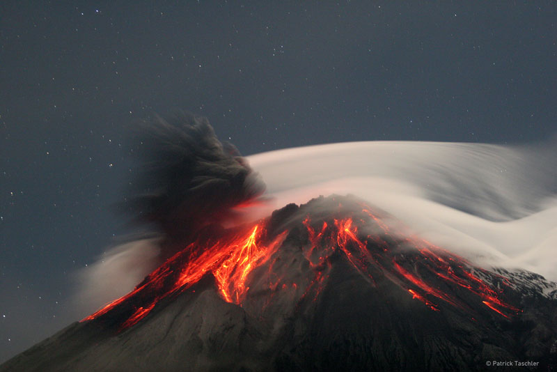
Tungurahua Erupts Credit & Copyright: PatrickTaschler
Explanation: Volcano Tungurahua erupted spectacularly last year. Pictured above, molten rock so hot it glows visibly pours down the sides of the 5,000-meter high Tungurahua, while a cloud of dark ash is seen being ejected toward the left. Wispy white clouds flow around the lava-lit peak, while a star-lit sky shines in the distance. The above image was captured last year as ash fell around the adventurous photographer. Located in Ecuador, Tungurahua has become active roughly every 90 years since for the last 1,300 years. Volcano Tungurahua has started erupting again this year and continues erupting at a lower level even today.
Click thumbnail for larger image
More information:
Tungurahua, Ecuador
Location: 1.467 S, 78.44 W
Elevation: 16,475 ft. (5023 m)
Tungurahua is an active stratovolcano also known as the “The Black Giant.” It has a 600 ft. (183 m) wide crater. Most of the volcano is covered by snow. It causes many tremors in the nearby city of Banos. Tungurahua’s lava is mostly composed of basalts. Tungurahua has had at least seventeen eruptions in historical times, its most recent occurring in 1944 when it erupted explosively from its central crater. Located about 25 miles (~40 km) west of Tungurahua is the largest volcano in Equador, Chimborazo and to the north about 50 miles(~80 km ) is Cotopaxi volcano.
Spread the word; friends don't allow friends to repeat history.
The prairie is one of North America’s great ecosystems and a vital habitat for many plants and animals. Over 98% of the prairie has been lost in the past 150 years—but some people are trying to bring it back, hectare by hectare. Restoring a prairie is a great challenge, requiring knowledge of biology, ecology, climatology, and even economics.
Are you up for the challenge? If you choose the right plants and animals, you can watch the prairie come to life before your eyes! Let’s begin!
North America’s prairie is divided into the tallgrass ecosystem and shortgrass ecosystem (plus an area in between—the “mixed grass” prairie). Which one do you want to restore?
This game fits neatly into geography curricula for a number of states, and also covers parts of the 7th grade social studies standards for Texas — if your state is covered by the tallgrass or shortgrass prairies as shown on the accompanying map, it’s likely your state standards include students’ learning about prairie ecosystems.
The game is fail-safe; it does not allow incorrect selections. It’s not a sim, really, but a basic introduction to what makes a successful prairie. Students should be able to master the game in 15 minutes.
Though developed way up north in Minnesota, the game and species are close to Texas prairies, too. The emphasis on soil points to some of the key errors made by farmers (encouraged by developers and the U.S. Department of Agriculture) which led to the Dust Bowl; this is a good enrichment exercise for Dust Bowl lesson plans. These games cover many of the requirements for Boy Scout merit badges, too: Environmental Science, Wildlife Management, and Soil and Water Conservation, and others.
Update, October 2011: No, I can’t find the game now, either. It appears the Bell Museum took the site down, and trusting (and hoping) they wouldn’t do that, I didn’t pirate any of the images, nor especially the game.
Here’s hoping someone will put the thing back on line, somewhere. If you find it, will you let me know? I’d like to renew the links. Several school systems went through this site to get to the game for classroom activities. It was a good thing.
It’s headed up by a bunch from downunder. U.S., Canadian and Mexican bloggers haven’t got on the bandwagon a lot, yet. As the organizers describe it:
On October 15th – Blog Action Day, bloggers around the web will unite to put a single important issue on everyone’s mind.
In its inaugural year, Blog Action Day will be co-ordinating bloggers to tackle the issue of the environment.
What Each Blogger Will Do
Bloggers can participate on Blog Action Day in one of two ways:
Publish a post on their blog which relates to an issue of their own choice pertaining to the environment.For example: A blog about money might write about how to save around the home by using environmentally friendly ideas. Similarly a blog about politics might examine what weight environmental policy holds in the political arena.Posts do not need to have any specific agenda, they simply need to relate to the larger issue in whatever way suits the blogger and readership. Our aim is not to promote one particular viewpoint, only to push the issue to the table for discussion.
Commit to donating their day’s advertising earnings to an environmental charity of their choice. There is a list of “official” Blog Action Day charities on the site, however bloggers are also free to choose an alternate environmental charity to donate to if they wish.
And that’s it.
A gentle nudge to a better planet. Seems like a good idea to me.
Anti-science and anti-evolution groups’ desperation erupts in odd ways. When scientists get together and discussion turns to the political movement known as intelligent design (ID), they express frustration at the sheer volume of supercilious ideas and claims that surge out of ID advocates. At its heart, this frustration has an almost-humorous puzzle: Scientists cannot tell what is a real claim from ID advocates, or what is a parody of those claims.
Neither can anyone else.
I stumbled into a mackerel-in-the-moonlight* example to show the problem: Jonathan Wells, a minister in the Unification Church of Rev. Sun Myung Moon, wrote a slap-dash screed against evolution published by right-wing cudgel publishing house Regnery, called The Politically Incorrect Guide to Darwinism and Intelligent Design.
Amazon.com invites authors to set up blogs, and Jonathan Wells has one. The only post there is reproduced in full below the fold — a list of . . . um, well . . . a top ten list of something (Wells just calls it a “top ten list”). It consists of amazing flights of fancy surrounding the issue of teaching science in public schools. I promise, I am not making any of this up — when I quote Wells, it will be his words entirely, completely, in context, uncut and unedited. If I didn’t tell you this was not parody, and if you have half your wits, you’d think either I was making it up, or somebody at Amazon was.
Point by point criticism, in brief, below the fold. I promise, I am not making this up.
__________________________________
* John Randolph is reputed to have said of Henry Clay: “Like a rotten mackerel by moonlight, he shines and stinks.” Read the rest of this entry »
Spread the word; friends don't allow friends to repeat history.
Bug Girl has all the details — spiders being closer to her blog’s core topic — but this news is just about 90 minutes from here, much closer for North Dallasites.
“At first, it was so white it looked like fairyland,” said Donna Garde, superintendent of the [Lake Tawakoni State] park about 45 miles east of Dallas. “Now it’s filled with so many mosquitoes that it’s turned a little brown. There are times you can literally hear the screech of millions of mosquitoes caught in those webs.”
Ah, the screech of millions of mosquitoes, about to be eaten.
Elron Steele submitted one of his — I’ll wager several readers here have photos that should be included in the encyclopedic site of photos of North American Wildlife. The project is collecting mammal photos right now (birds, reptiles and invertebrates yet to come?)
I note the project has only one not-very-clear photo of a tassel-eared squirrel, and I know there are at least two species of these things ranging through Arizona, New Mexico and Colorado, and I know there are no fewer than four Boy Scout Camps in those areas — so does some Scout or Scouter have a good shot of one of the tassel-eared guys to include?
In my recent excursion into New Mexico, we were south of Raton when I spotted a fine specimen of a pronghorn antelope alongside the road. Within a few minutes we had spotted way over a dozen, and returning along the route a week later we must have seen at least 50 of them, in groups as large as a dozen. While I got no decent photos zipping along at 60 mph, surely someone from one of the mountain states has a very good picture that could be contributed.
And teachers: This is a great source of images for student projects and presentations for biology, environmental science, history and geography.
Economics teachers know stock market mavens and watchers call August the “dog days.” It’s slow time, usually — which puts a piquant point on the market gyrations of the past three weeks.
Roman astrologers and astronomers named two constellations in which they thought they saw the outline or framework of dogs. They named one Big Dog, and the other Little Dog — though, in Latin, they became Canis Major and Canis Minor, respectively.
Sirius is in Canis Major. Sirius is the brightest of the true stars (not so bright as Venus, but Venus is a planet). The name “Sirius” came from ancient Egyptians, who named it after their god Osiris; Osiris, of course, had the head of a dog (“Sirius” is a Latin corruption of Osiris, I suppose). So we have a star named after a dog-headed god, in a constellation called the Big Dog.
Or, until that account is unsuspended by the forces supporting Donald Trump: Follow @FillmoreWhite, the account of the Millard Fillmore White House Library
We've been soaking in the Bathtub for several months, long enough that some of the links we've used have gone to the Great Internet in the Sky.
If you find a dead link, please leave a comment to that post, and tell us what link has expired.
Thanks!
Retired teacher of law, economics, history, AP government, psychology and science. Former speechwriter, press guy and legislative aide in U.S. Senate. Former Department of Education. Former airline real estate, telecom towers, Big 6 (that old!) consultant. Lab and field research in air pollution control.
My blog, Millard Fillmore's Bathtub, is a continuing experiment to test how to use blogs to improve and speed up learning processes for students, perhaps by making some of the courses actually interesting. It is a blog for teachers, to see if we can use blogs. It is for people interested in social studies and social studies education, to see if we can learn to get it right. It's a blog for science fans, to promote good science and good science policy. It's a blog for people interested in good government and how to achieve it.
BS in Mass Communication, University of Utah
Graduate study in Rhetoric and Speech Communication, University of Arizona
JD from the National Law Center, George Washington University


 Posted by Ed Darrell