I do like a little well-done time lapse. In this one, the action of the clouds playing peek-a-boo with the Moon is a lot of fun. It’s just the sort of astronomical action I love to watch in the National Parks.
Desert sunset at Jumbo Rocks Campground, Joshua Tree NP. Photo by Brad Sutton/NPS
I wonder where Lian Law took that time-lapse of the Moon. Anyone know?
Saguaro cactus and the Milky Way; photo by Bob Wick, U.S. Bureau of Land Management. Via Wilderness Society on Twitter, and flickr.
The Wilderness Society added a quote:
“I wish to know an entire heaven and an entire earth.” – Henry David Thoreau
If I had to guess, I’d say somewhere between Phoenix and Tucson, but I don’t know. Mr. Wick managed to get a good exposure without distorting the shapes of the stars. Somewhere far away from city lights.
Anyone have more details? Gotta track down the quote, too.
February 23, 1945. It’s a date that will live in famous heroics, war brutality, photography, and bronze.
On the morning of February 23, U.S. troops raised the U.S. flag on a hill known as Mt. Suribachi, on the island of Iwo Jima — a visual signal to U.S. troops that the high ground had been taken, and the battle turned for the U.S.
First flag-raising on Mt. Suribachi, Iwo Jima, on February 23, 1945. Photograph for Leatherneck Magazine by Sgt. Lou Lowery.
Later in the day, an officer ordered a larger flag to be posted, to be more visible. AP photographer Joe Rosenthal caught that raising on film.
Is this the most iconic photo ever? Wikimedia caption: Raising the Flag on Iwo Jima, Joe Rosenthal’s historic photo depicts five United States Marines and one sailor raising an American flag over Mount Suribachi during the Battle of Iwo Jima. The image above is an Associated Press photograph that won the Pulitzer Prize for Photography. It was taken by Joe Rosenthal on February 23, 1945.
February 23 does not appear in the list of dates by law recommended for Americans to fly the U.S. flag. You may want to fly yours today, anyway.
Mt. Suribachi’s prominence is clear in this photo of the island of Iwo To, as it is known in Japan. Suribachi is a 546-foot (166 m) dormant volcanic cone, on the southern tip of the island. Wikipedia image
Spread the word; friends don't allow friends to repeat history.
Old buddy Gil Brassard (from the airline days) sent me a slightly different version of this video; this is the YouTube version from “Mr. Goodviews.” It’s shot from the cockpit of a commercial airliner coming into Queenstown, New Zealand:
Details:
Published on Oct 23, 2013
…sometimes what a pilot sees in a day, people won’t see in their lifetimes..
amazing Queenstown, New Zealand.
I invite people of the world to come visit this beautiful country and its people.
It was probably shot with a camera like a GoPro stuck on the window pointing out, in robot mode so the copilot and pilot gave full attention to flying the aircraft, and were not distracted by operating a camera in a cockpit. I mention this because US Federal Aviation Administration is looking into claims that selfies from cockpits — usually of small planes — may have contributed to accidents in the air. We may see some bans on shooting such videos in the future.
Enjoy ’em while you can.
Noodling around YouTube, I also found these videos of airplanes in and out of Queenstown, New Zealand.
And a passenger’s view of take-off and climb-out (longer piece, no music edited in):
Published on Feb 7, 2014
Flying over New Zealand from south to north. Nice views of Lake Wakatipu and Queenstown. Passing over Mount Cook – the highest mountain in New Zealand. Later a landing at Auckland Airport.
Better videos of this route anywhere?
Even cooler videos of other routes?
Can’t say how often I’ve regretted not having a good video camera on my flight from Farmington, New Mexico, to Provo, Utah, in a Cessna, especially coming down Provo Canyon. But alas, that was before video was even portable . . .
Spread the word; friends don't allow friends to repeat history.
Enough of the jokes about how nature makes Dallas beautiful by covering everything up.
There were some nice views of Dallas today, with the fog, though.
From WFAA-TV’s tower camera, just before sunrise:
Dallas in the fog, December 9, 2014; photo from WFAA-TV’s tower camera.
This photo produced the most stir, I think. Terry Maxon posted it at his Aviation Blog with the Dallas Morning News:
Maxon wrote: “Mike Alvstad was flying into Dallas/Fort Worth on Tuesday morning and took a photo as his flight from Tampa, Fla., passed south and west of downtown Dallas. He shared it with Lee Evans, who shared it with us, and we liked it a lot.”
In the sea of clouds, you can see the top of Reunion Tower a bit lower to the right. There’s the wedge-topped Fountain Place in the lower center of the downtown cluster. Off to the left by itself is Cityplace, we believe.
Note that even though we could barely see a block ahead of us at ground level, the skyscrapers are casting shadows on the top of the fog clouds.
You want to see what it looked like from the upper floors of those buildings? Kathryn’s office is below the clouds. When I worked in the high floors of the old Ling/Temco/Vought Building (now Trammell Crow Tower, I think) we didn’t have cell phones with cameras, and electronic imaging was in its commercialized infancy. I never had the old 35mm film cameras with me on those few occasions when we rode the elevators up out of the fog, and could almost wave to someone in the tower across the way. Justin Turveen got off a few shots today, but is being stingy with the photos at his flickr site. Check it out if you wish.
It was foggy across the area starting last night, including Denton, which is home to the University of North Texas and Texas Women’s University:
Photo by Samantha Irene Balderas, at the campus of the University of North Texas (UNT), December 8, 2014
Jeff Rogers got a sunrise in McKinney, through the fog:
Sunrise through fog in McKinney, Texas. Photo by Jeff Rogers
Angelica Villalobos Yates surprised a tree in the Texas fog.
Toni Wolff Margolis caught birds on a wire in the fog.
From the tall buildings in downtown Dallas, a shot by Cindy Ackerson Bivins:
Photo from the Bank of America Tower of other Dallas buildings in the fog, December 9, 2014. Photo by Cindy Ackerson Bivins
Mike Prendergrast at Aerial DFW.com sent his DJI Phantom 2 Vision Plus Drone to work, rising above the clouds, with good results, I think. He had me when I read that he included some time-lapse in there . . .
(Yes, Prendergrast is a great guy, and a good photographer, and he followed the rules and stayed low and out of the way of aircraft.)
Do you have a nice shot of Dallas in the fog to share? Send it to me, or post it in comments.
Tip of the old scrub brush to Suzy Bangs, who I hope is joining us again this week to take a hot Christmas meal and cheer to the good people at the Pleasant Grove Senior Recreation Center (that’s Pleasant Grove, Texas). Thanks, too, for the splash from Dubious Quality (who is this Gilbert fellow?).
Spread the word; friends don't allow friends to repeat history.
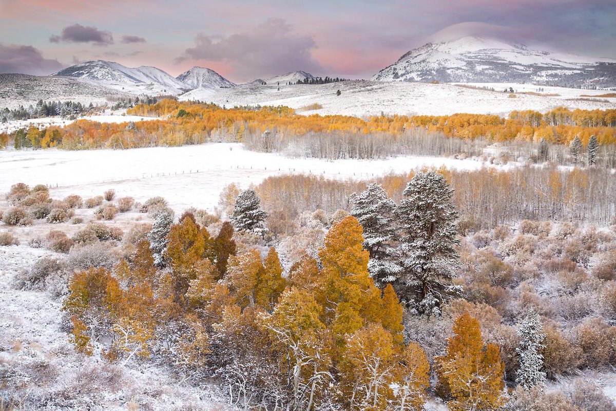
From our public lands, from the Twitter feed of the U.S. Department of Interior:
@Interior caption: Fall foliage and snow-capped peaks make for a stunning shot of Conway Summit #California @BLMca #nature
In my winter drives through the desert mountains of the Great Basin I often marveled at how a dusting of snow could turn a landscape generally painted in tones of brown with a little green into almost black and white. Then there are those black and white landscapes slashed by stunning gashes of color, or tinted subtley.
Conway Summit shows the stunning gashes of color this week. Grays, whites, blacks — and gold and pink. It’s in the western part of California, near Nevada and Mono Lake:
Conway Summit is named after John Andrew Conway, a settler in the area in 1880.[3][4] Geographically, it was formed from an upland plateau by the sinking of the land in the Mono basin area.[5] The Sawtooth Ridge of the eastern Sierra Nevada, topped by 12,279-foot (3,743 m) Matterhorn Peak, rise to the west of the pass; Green Creek and Virginia Lakes, in the Sierra Nevada to the west of the pass, are two local destinations for fishing, camping and aspen trees. The Bodie Hills and the infamous Bodie ghost town lie to the east.
This scene comes from our public lands, the undifferentiated lands held in trust by the Bureau of Land Management (BLM) and managed for multiple uses. You and I may look at this photo and marvel at the beauty of America, and say a little prayer of thanks for our public lands. Sens. Mike Lee and Ted Cruz see potential for high-dollar vacation residences throughout this scene, if only the land could be sold off.
Spread the word; friends don't allow friends to repeat history.
America’s first national monument, Devils Tower is a geologic feature that protrudes out of the rolling prairie in Wyoming. David Lane captured this amazing 16-image panorama of the monument illuminated by the Milky Way and green airglow. Of visiting Devils Tower, David says: “From ancient stories of the Pleiades taking refuge at the top to the generations of Native Americas that held it sacred, it had a deep sense of age and a stoic nature that impressed me. It’s so unexpected, so large in person, so steeped in traditions.”
From the photo archives of the Boston Public Library, we get this postcard:
Post card from the archives of the Boston Public Library: “Boyhood Home of President Wm. McKinley, Lisbon, Ohio. Now Part of Columbiana County Boy Scout Reservation. Built in 1808.
Boyhood home of President Wm. McKindley, Lisbon, Ohio. Now part of Columbiana County Boy Scout Reservation, built in 1808
File name: 06_10_016732 Title: Boyhood home of President Wm. McKinley, Lisbon, Ohio. Now part of Columbiana County Boy Scout Reservation, built in 1808 Created/Published: Tichnor Bros. Inc., Boston, Mass. Date issued: 1930 – 1945 (approximate) Physical description: 1 print (postcard): linen texture, color; 3 1/2 x 5 1/2 in. Genre: Postcards Subjects: Historic buildings
Notes: Collection: The Tichnor Brothers Collection Location: Boston Public Library, Print Department Rights: No known restrictions
Is this historic building still part of a Scout camp?
Camp McKinley is located in Columbiana County, near Lisbon, Ohio. The 300 acre camp has been owned and operated by the Boy Scouts of America since 1934.
Camp McKinley is the Buckeye Council’s most historic camp. The modern history of the area began back in 1807 when Ohio was a new state of only three years. Gideon Hughes, a local businessman, built a blast furnace in “new Lisbon” to supply the needs of the settlers heading west. The remains of the Rebecca Furnace are still visible on the camp property. Mr. Hughes also built a stone “mansion” across from his furnace. The house, known as the McKinley homestead, was the home of President William McKinley’s grandparents for a number of years. President McKinley no doubt spent many summers wandering the hills of the present Camp McKinley. The Stone House is now the residence of the Camp Ranger.
President McKinley slept here, as a boy.
Scout camp ranger’s house does not seem to you to be a respectful enough use of a president’s boyhood home? Buckeye Council has preserved the home at least in its exterior appearance.
Philmont caption: A view of the Philmont sky this weekend! The Tooth of Time is visible in the lower right corner. We have a Canon 5D Mark II with a 16-35 2.8 lens. The exposure was 30 seconds. Bryan Hayek took the photo.
Milky Way viewed from the National Scout Ranch at Philmont, New Mexico.
Or, until that account is unsuspended by the forces supporting Donald Trump: Follow @FillmoreWhite, the account of the Millard Fillmore White House Library
We've been soaking in the Bathtub for several months, long enough that some of the links we've used have gone to the Great Internet in the Sky.
If you find a dead link, please leave a comment to that post, and tell us what link has expired.
Thanks!
Retired teacher of law, economics, history, AP government, psychology and science. Former speechwriter, press guy and legislative aide in U.S. Senate. Former Department of Education. Former airline real estate, telecom towers, Big 6 (that old!) consultant. Lab and field research in air pollution control.
My blog, Millard Fillmore's Bathtub, is a continuing experiment to test how to use blogs to improve and speed up learning processes for students, perhaps by making some of the courses actually interesting. It is a blog for teachers, to see if we can use blogs. It is for people interested in social studies and social studies education, to see if we can learn to get it right. It's a blog for science fans, to promote good science and good science policy. It's a blog for people interested in good government and how to achieve it.
BS in Mass Communication, University of Utah
Graduate study in Rhetoric and Speech Communication, University of Arizona
JD from the National Law Center, George Washington University


 Posted by Ed Darrell