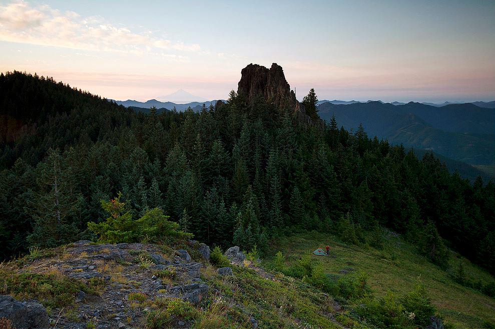
There is just something about a campfire that soothes human souls, brings joy to and instills awe in people who gather around one.
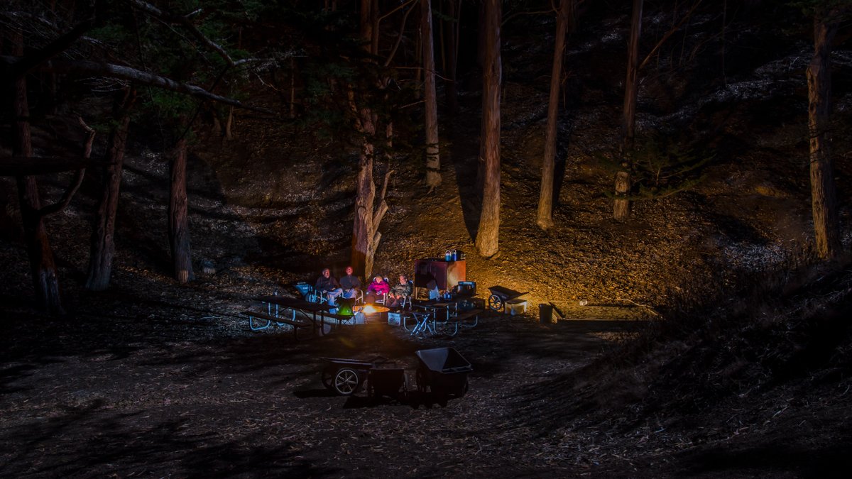
Thanks and a shake of the old scrub brush to the Golden Gate National Park, on Twitter.
There is just something about a campfire that soothes human souls, brings joy to and instills awe in people who gather around one.
Thanks and a shake of the old scrub brush to the Golden Gate National Park, on Twitter.
 Leave a Comment » |
  Camping, National Parks, Outdoor Recreation | Tagged: Campfires, Camping, National Parks, Outdoor Recreation |
  Permalink
 Posted by Ed Darrell
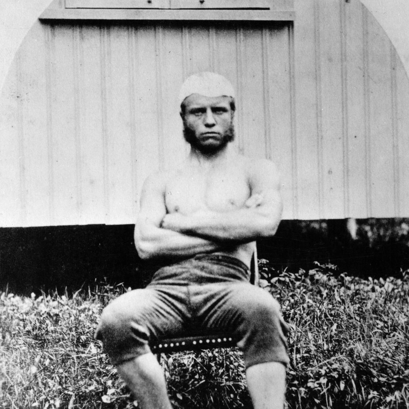
Young Theodore Roosevelt, as a boxer and wrestler at Harvard University. Harvard University image.
Theodore Roosevelt was born in Manhattan on October 27, 1858. 160 years ago, today.
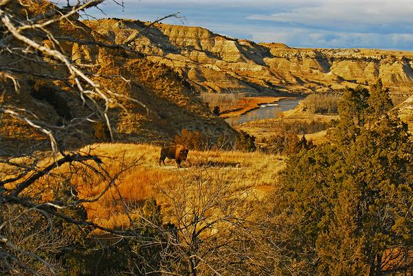
Among many other things in his life, he was for a time a cowboy in the Dakota Territory, in the area of North Dakota where today resides the Theodore Roosevelt National Park.
Look closely at the picture. You can almost see Teddy. He was a powerful, guiding force behind the movement to protect precious, historic, scientifically valuable and beautiful lands, by the federal government.
Happy birthday, Theodore Roosevelt! Let’s celebrate with a great shot of @TRooseveltNPS #NorthDakota
In 1922, the U.S. Navy started celebrating Navy Day on Roosevelt’s Birthday, October 27, to honor Roosevelt. When he had been Secretary of the Navy, Roosevelt overhauled the entire fleet and brought the U.S. Navy onto the world stage as a modern, major fighting force worthy of deep respect. When we fly the flag for Navy Day, we also honor one of the Navy’s greatest leaders, Navy Secretary Theodore Roosevelt.
Happy Theodore Roosevelt’s birthday, America.
More:
A short, mostly accurate history of Teddy Roosevelt, from some guy named Jeremiah:
In his life, Teddy Roosevelt often lived outside the box, bigger than life. Running for election in 1912, Roosevelt was shot in the chest before a speech in Milwaukee. The copy of the speech and things in his pocket protected him, but it was still quite a blow to his chest. Roosevelt gave the speech before going to a hospital. Here’s a headline from the Atlanta Constitution on the affair.
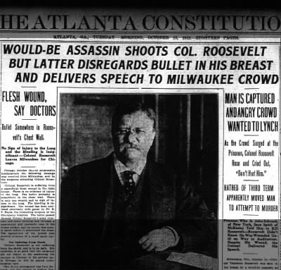
Front page of the Atlanta Constitution, October 15, 1912, telling the story of Teddy Roosevelt’s having been shot in Milwaukee the previous day.
2 Comments | Conservation, History, National Parks, Outdoor Recreation, Theodore Roosevelt | Tagged: Conservation, History, Outdoor Recreation, Theodore Roosevelt, Theodore Roosevelt National Park | Permalink
Posted by Ed Darrell
Oh, there’s a little technical wizardry involved in this one, stitching it together.
But, wow!

White Pocket in the Vermilion Cliffs National Monument, Arizona. Brilliant photography and stitching by Dave Lane Astrophotography, via the U.S. Department of Interior.
A more full description from Interior’s Facebook page:
Located in a remote and unspoiled part of northern Arizona, Vermilion Cliffs National Monument is a geologic treasure. For those who can’t get a permit to places like The Wave, White Pocket is an equally stunning place to explore — day or night. Pictured here, the area’s unusual rock formation is crowned by the Milky Way with Saturn, Mars and the Rho Ophiuchus region all visible. Multi-image photo (42 images stitched together in a 6 x 7 matrix) courtesy of David Lane (Dave Lane Astrophotography).
Dave Lane’s work amazes, doesn’t it?
Tip of the old scrub brush to Kathryn Knowles.
Leave a Comment » | Astronomy, Milky Way, Outdoor Recreation, photography, Public Lands | Tagged: Astronomy, Milky Way, Outdoor Recreation, photography, Public Lands, Vermilion Cliffs National Monument | Permalink
Posted by Ed Darrell
Your public lands at work, filling you with awe.

From BLM National’s Twitter feed: A full moon 🌕 lights up the sky at Granite Mountain Wilderness, #California. (Photo: Bob Wick)
BLM National put this photo up on September 30, so we might assume the photo is from September’s Moon, as well.
More:
Leave a Comment » | Astronomy, Bureau of Land Management BLM, Outdoor Recreation, photography, Wilderness | Tagged: Astronomy, Bureau of Land Management, Granite Mountain Wilderness - California, Outdoor Recreation, photography | Permalink
Posted by Ed Darrell
First Saturday in June is National Trails Day.
It’s a life-changing celebration, if you get out on a trail, and then keep going.
Check with the American Hiking Society to see if there’s an event near you. Take a hike in any case.
Maybe take a photo. There’s an annual photo contest.

2015 National Trails Day photograph winner, from Alexandra Novitske, taken at the Great Sand Dunes National Preserve, Colorado. American Hiking Society
3 Comments | Hiking, Outdoor Recreation | Tagged: American Hiking Society, National Trails Day, Outdoor Recreation | Permalink
Posted by Ed Darrell

From Interior’s Facebook feed: The massive sandstone monoliths along Park Avenue Trail at Arches National Park in Utah have imaginative and descriptive names. You won’t regret this easy one-mile hike. Where else can you walk in the shadows of the Tower of Babel, the Organ, the Three Gossips and Sheep Rock? Photo by Bud Walley (www.sharetheexperience.org). — at Arches National Park.
And a reminder that Utah’s Sen. Mike Lee and Texas’s Sen. Ted Cruz think this land should be developed. Want a condo on that cliff?
I’d prefer to hike it. I’d prefer to know it’s there, available for hiking without development, even when I can’t hike it.
It’s your public land. You get to use it, undeveloped, or you don’t get to use it if the land is developed. We still have a voice, and time to speak.
4 Comments | Hiking, National Parks, Outdoor Recreation, Public Lands, Utah | Tagged: Arches National Park, Outdoor Recreation, Park Avenue Trail, Public Lands, Utah | Permalink
Posted by Ed Darrell
Theodore Roosevelt was born in Manhattan on October 27, 1858.
Among many other things in his life, he was for a time a cowboy in the Dakota Territory, in the area of North Dakota where today resides the Theodore Roosevelt National Park.
Look closely at the picture. You can almost see Teddy. He was a powerful, guiding force behind the movement to protect precious, historic, scientifically valuable and beautiful lands, by the federal government.
Happy birthday, Theodore Roosevelt! Let’s celebrate with a great shot of @TRooseveltNPS #NorthDakota
Happy Theodore Roosevelt’s birthday, America.
More:
A short, mostly accurate history of Teddy Roosevelt, from some guy named Jeremiah:

Yes, this is mostly an encore post. Fighting ignorance requires patience.
Leave a Comment » | Conservation, History, National Parks, Outdoor Recreation, Theodore Roosevelt | Tagged: Conservation, History, Outdoor Recreation, Theodore Roosevelt, Theodore Roosevelt National Park | Permalink
Posted by Ed Darrell

Click for a larger view — see the petrified trees, darker brown and lying horizontal? American Southwest posted this on Facebook, “Two petrified trees at the edge of a plateau on the north side of De-Na-Zin Wash.”
This is BLM land, but real wilderness — no trails. More examples of what makes America great, and worth defending.
It seems to be a great place for stargazing, too.
Leave a Comment » | Bureau of Land Management, Natural history, Outdoor Recreation | Tagged: Bureau of Land Managment, De-Na-Zin Wilderness, Natural history, New Mexico, Outdoor Recreation, Petrified trees | Permalink
Posted by Ed Darrell
We seek renewal in wilderness, and find that wilderness itself renews with every sunrise.
@BLMOregon: Rooster Rock #sunrise from the Table Rock #Wilderness near Molalla, #Oregon – photo: Mike Scofield #camping #hiking
Mike Scofield is a lucky guy to have been there to get that shot.
More:
Leave a Comment » | Outdoor Recreation, photography, Public Lands, Travel, Wilderness | Tagged: Outdoor Recreation, photography, Public Lands, Travel, Wilderness | Permalink
Posted by Ed Darrell
I’m stealing this wholesale from the Tumblr site of the U.S. Department of Interior, America’s Great Outdoors.
The site features great Bureau of Land Management (BLM) sites often, and this week will highlight places on BLM lands in California that are great for stargazing. They call it a “social media takeover” of the feed by California BLM.
How good is the star watching? Look at these photographs. (I’ve added a few comments of my own.)

Piper Mountains Wilderness, California, by Bob Wick
Another great place to see the Milky Way.

King Range National Conservation Area, California, by Bob Wick
These photos are stunning. These .gifs also demonstrate how the atmosphere really is a fluid, flowing over mountains — “the curvaceous hills of California,” the Rev. Dr. Martin Luther King, Jr., called them in a travelogue he delivered from the Lincoln Memorial in 1963. Teachers, not just great geography illustrations, but also illustrations for environmental science and physics.

Amargosa Wild and Scenic River, California, by Bob Wick

San Gorgonio Wilderness, California, by Dan Maus

Slinkard Wilderness, California, by Bob Wick
Slinkard Wilderness? I admit I do not know of some of these places. I’m willing to learn, first hand . . .

Kingston Range Wilderness, BLM California, by Bob Wick, BLM

California Coastal National Monument, California, by Bob Wick
California Coastal National Monument reminds me that Republicans in Congress push a proposal to prevent future presidents from protecting such lands with National Monument designation under the Antiquities Act. Critics say these BLM lands are not special enough to merit protection.
Do the photos say otherwise?

North Maricopa Wilderness, California, by Bob Wick

Cadiz Dunes Wilderness, California, by Bob Wick

Point Arena-Stornetta in California Coastal National Monument, California, by Bob Wick
A printer-friendly, and search engine-friendly list of the sites above, if you’re putting them into your GPS or search feature to plan your vacation:
June #conservationlands15 Social Media Takeover: Top 15 Places to Stargaze on the #mypubliclandsroadtrip in BLM California
1. Amargosa Wild and Scenic River
2. Cadiz Dunes Wilderness
3. California Coastal National Monument
4. Carrizo Plain National Monument
5. Fort Ord National Monument
6. Kingston Range Wilderness
7. Little Black Sands Beach in King Range National Conservation Area
8. Lost Coast Trail at King Range National Conservation Area
9. North Maricopa Wilderness
10. Piedras Blancas Light Station Outstanding Natural Area
11. Piper Mountains Wilderness
12. Point Arena-Stornetta in California Coastal National Monument
13. San Gorgonio Wilderness
14. Slinkard Wilderness
15. Whipple Mountains WildernessThanks for following the June #conservationlands15 features on My Public Lands Tumblr, and our takeover of americasgreatoutdoors Instagram account (https://instagram.com/usinterior/). Stay tuned all week as the #mypubliclandsroadtrip visits these top 15 California spots for stargazing and much more.
Bob Wick and Dan Maus may have the best jobs in U.S. government service, judging by their photos. Nice of them to share.
What do your shots from those places look like? Show us in comments, maybe?
Leave a Comment » | Astronomy, Bureau of Land Management (BLM), Milky Way | Tagged: America's Great Outdoors, Astronomy, Milky Way, Outdoor Recreation, photography, Public Lands, Travel | Permalink
Posted by Ed Darrell

From the Facebook site of the U.S. Department of Interior: Visit Black Canyon of the Gunnison National Park in Colorado and see some of the steepest cliffs, oldest rock and craggiest spires in North America. Pictured here is a stunning shot of the #MilkyWay rising above the Black Canyon. Photo courtesy of Greg Owens — at Black Canyon of the Gunnison National Park.
Looking at that river, it’s difficult to understand that it’s just half the flow. Ranchers and farmers bored a tunnel to channel half the water of the river to the Uncompahgre Valley through the 5 mile-long Gunnison Tunnel, completed in 1909. Many of the overlooks into the incredibly steep canyon reveal only snippets of the ribbon of water that runs the whole length of the canyon.
I like how this photograph captures reflected light off the water, and makes the river appear easier to see than it usually is, especially at night.
Stunning geology, great hikes — you should go.
Especially you should go if you think about the geology that contradicts creationism. The canyon is loaded with volcanic inserts that deny flood geology and every other geological distortion offered by creationists, maybe better than the Grand Canyon in that regard.
More:
Leave a Comment » | Astronomy, Milky Way, National Parks, Nature, Outdoor Recreation, photography, Travel | Tagged: Astronomy, Black Canyon of the Gunnison N.P., Milky Way, Nature, Outdoor Recreation, photography, Travel | Permalink
Posted by Ed Darrell
Four minutes of a glorious full Moon rising over Joshua Tree National Park — reduced to a 6-second Vine.
I do like a little well-done time lapse. In this one, the action of the clouds playing peek-a-boo with the Moon is a lot of fun. It’s just the sort of astronomical action I love to watch in the National Parks.

Desert sunset at Jumbo Rocks Campground, Joshua Tree NP. Photo by Brad Sutton/NPS
I wonder where Lian Law took that time-lapse of the Moon. Anyone know?
More:

Screen capture of the Moon rise Vine video by Lian Law, National Park Service.
Leave a Comment » | Astronomy, National Parks, Outdoor Recreation, photography | Tagged: Astronomy, National Parks, Outdoor Recreation, photography | Permalink
Posted by Ed Darrell
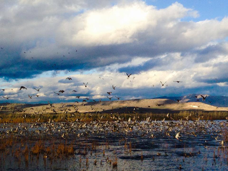
Flights Arriving Daily! Birds are funneling into Klamath Basin National Wildlife Refuge Complex Photo: A Mize/USFWS; from @USFWSPacSWest
Photo from last fall. Some of the ducks probably overwinter. Others continued south, and will be arriving at Klamath NWR soon, again, heading north.
Our public lands at work.
More:
1 Comment | National Wildlife Refuge, Outdoor Recreation, photography, Public Lands, Wildlife | Tagged: Klamath NWR Complex, Outdoor Recreation, photography, Public Lands, Wildlife | Permalink
Posted by Ed Darrell
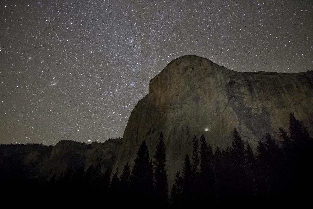
Tommy Caldwell and Kevin Jorgeson on January 14 completed their free-climb ascent of the 3,000-foot Dawn Wall on El Capitan in Yosemite National Park — labeled the toughest free climb in the world.
Wow. Just wow.

The path up, the Dawn Wall on El Capitan. San Francisco Chronicle graphic by John Blanchard, on a photo by Nate Ptacek/Patagonia
This interactive piece at the New York Times should give the proper sense of awe for what they’ve done. (If you’re a climber, you may want to get some more technical reports from YosemiteBigWall.com, who contributed to that interactive presentation.)
PBS’s Newshour had among the best reports:
Leave a Comment » | Geography - Physical, History, National Parks, Outdoor Recreation, Travel, Yosemite | Tagged: Dawn Wall, Free Climb, geography, History, Kevin Jorgeson, Outdoor Recreation, Rock Climbing, Tommy Caldwell, Travel, Yosemite National Park | Permalink
Posted by Ed Darrell
NBC News correspondent Hallie Jackson posted this photo on her Twitter feed, a shot from NBC photographer Scot Kilian:
@HallieJackson: Incredible shot from NBC’s Scott Kilian: that tiny dot of light on side of #DawnWall is where the climbers slept.
It’s a long exposure, enough that the stars brighten the black sky, but not quite so much that the stars become streaks on the photo. Long enough that the lights used by Tommy Caldwell and Kevin Jorgeson register on the CMOS (I’m assuming no film here).
Incredibly, their tents are pitched upon the rock, where mountain goats and cliff-dwelling birds fear to tread. It’s very much a vertical sheet of almost smooth rock.
And it’s a great photo. In these particularly troubled times, any light shining on human cooperation to achieve great things becomes a beacon.
More:
Leave a Comment » | National Parks, Outdoor Recreation, Yosemite | Tagged: Dawn Wall, Half Dome, Hallie Jackson, Kevin Jorgeson, Outdoor Recreation, Rock Climbing, Scott Kilian, Tommy Caldwell, Yosemite National Park | Permalink
Posted by Ed Darrell


Ed Darrell on Texas's Colorado River


Come on in, the water's fine. Come often: Cleanliness is next to godliness.


