(NASA caption) Ozone depletion occurs in cold temperatures, so the ozone hole reaches its annual maximum in September or October, at the end of winter in the Southern Hemisphere. Credits: NASA/NASA Ozone Watch/Katy Mersmann
Good news from NASA and NOAA: The ozone hole over Antarctica is shrinking, because policy makers heeded warnings from scientists, and they acted in the 1980s to stop the pollution that made the ozone hole grow into hazard.
In other words, cleaning up air pollution works to reduce problems.
If we apply those same principles to global warming climate change, we can save the planet: Listen to scientists, band together internationally, take effective action to stop the pollution.
BUT, much of the shrinkage in the past two years was due to warming atmosphere, which reduces the cold weather period during which the ozone hole grows. In other words, effects of the anti-pollution action isn’t yet clear.
“The Antarctic ozone hole was exceptionally weak this year,” said Paul A. Newman, chief scientist for Earth Sciences at NASA’s Goddard Space Flight Center in Greenbelt, Maryland. “This is what we would expect to see given the weather conditions in the Antarctic stratosphere.”
The smaller ozone hole in 2017 was strongly influenced by an unstable and warmer Antarctic vortex – the stratospheric low pressure system that rotates clockwise in the atmosphere above Antarctica. This helped minimize polar stratospheric cloud formation in the lower stratosphere. The formation and persistence of these clouds are important first steps leading to the chlorine- and bromine-catalyzed reactions that destroy ozone, scientists said. These Antarctic conditions resemble those found in the Arctic, where ozone depletion is much less severe.
In 2016, warmer stratospheric temperatures also constrained the growth of the ozone hole. Last year, the ozone hole reached a maximum 8.9 million square miles, 2 million square miles less than in 2015. The average area of these daily ozone hole maximums observed since 1991 has been roughly 10 million square miles.
Although warmer-than-average stratospheric weather conditions have reduced ozone depletion during the past two years, the current ozone hole area is still large because levels of ozone-depleting substances like chlorine and bromine remain high enough to produce significant ozone loss.
Scientists said the smaller ozone hole extent in 2016 and 2017 is due to natural variability and not a signal of rapid healing.
First detected in 1985, the Antarctic ozone hole forms during the Southern Hemisphere’s late winter as the returning sun’s rays catalyze reactions involving man-made, chemically active forms of chlorine and bromine. These reactions destroy ozone molecules.
Thirty years ago, the international community signed the Montreal Protocol on Substances that Deplete the Ozone Layer and began regulating ozone-depleting compounds. The ozone hole over Antarctica is expected to gradually become less severe as chlorofluorocarbons—chlorine-containing synthetic compounds once frequently used as refrigerants – continue to decline. Scientists expect the Antarctic ozone hole to recover back to 1980 levels around 2070.
Ozone is a molecule comprised of three oxygen atoms that occurs naturally in small amounts. In the stratosphere, roughly 7 to 25 miles above Earth’s surface, the ozone layer acts like sunscreen, shielding the planet from potentially harmful ultraviolet radiation that can cause skin cancer and cataracts, suppress immune systems and also damage plants. Closer to the ground, ozone can also be created by photochemical reactions between the sun and pollution from vehicle emissions and other sources, forming harmful smog.
Although warmer-than-average stratospheric weather conditions have reduced ozone depletion during the past two years, the current ozone hole area is still large compared to the 1980s, when the depletion of the ozone layer above Antarctica was first detected. This is because levels of ozone-depleting substances like chlorine and bromine remain high enough to produce significant ozone loss.
More work to do; but at least the damage is not increasing dramatically. While it would be good to be able to report that human action to close the ozone hole had produced dramatic results, it is still useful to track the progress of this action, especially when global warming/climate change dissenters frequently argue falsely that the ozone hole never existed, and warming is a similar hoax.
NASA’s AURA satellite group said the ozone holes should be repaired and gone by 2040, 23 years from now.
We hope they’re right.
(NASA caption) At its peak on Sept. 11, 2017, the ozone hole extended across an area nearly two and a half times the size of the continental United States. The purple and blue colors are areas with the least ozone. Credits: NASA/NASA Ozone Watch/Katy Mersmann
Drought in the West, Central and Southern Plains, and Midwest. Long- and short-term dryness will increase wildfire risk and continue to have impacts on water resources and agriculture.
El Niño development likely this summer or autumn. According to NOAA’s Climate Prediction Center, there is a greater than 65 percent chance of El Niño conditions developing later this year, which could have significant impacts on temperature and precipitation patterns across the U.S. More information is available from the Climate Prediction Center.
The average temperature for the contiguous U.S. during April was 51.7°F, which was 0.7°F above the 20th century average. This was the 46th warmest April in the 120-year period of record.
Much of the contiguous U.S. had April temperatures near the 20th century average. Above-average temperatures were scattered along the West Coast and in the Southwest, the Southern Plains, and across parts of the Ohio Valley and the Southeast. Below-average temperatures were observed across parts of the Upper Midwest and Northern Plains. No state had April temperatures among their 10 warmest or coolest.
Alaska had the 12th warmest April of its 96-year period of record, with a temperature 3.8°F above the 1971-2000 average. This was the warmest April for Alaska since 2007. Much of the warmth was situated in western Alaska, where Nome had its fourth warmest April since local records began in 1907. The April precipitation total in Alaska was 23.3 percent below the 1971-2000 average, the 23rd driest April on record. Anchorage had its fifth driest April with only nine percent of normal monthly precipitation.
The April contiguous U.S. precipitation total of 2.83 inches was 0.31 inch above the 20th century average and the 30th wettest April on record.
Above-average precipitation in the Upper Midwest resulted in Wisconsin having its third wettest April and Minnesota its eighth wettest. Heavy precipitation across the Southeast, particularly near the end of the month, caused Alabama to have its fifth wettest April, Georgia its seventh wettest, and Florida its ninth wettest.
On April 29th and 30th, torrential rain fell across the Southeast, Mid-Atlantic and Northeast causing significant flash flooding. The Gulf Coast of Alabama and the Florida panhandle bore the brunt of the heavy rains. At the Pensacola Regional Airport, in Florida, the two-day precipitation total was 20.47 inches, with 15.55 inches of the total falling on the 29th, breaking both one-day and two-day precipitation records; local records date back to 1879. On the 29th, Mobile, Alabama received 11.24 inches of rain, the third greatest calendar day rainfall total for the city since local records began in 1871. According to the 2014 National Climate Assessment released on May 6th, the amount of heavy precipitation falling in single events has increased by 27 percent across the Southeast since 1958. This event is consistent with projections of increases in the frequency and intensity of extreme precipitation events across the U.S. as the world warms.
Below-average precipitation was observed across parts of the West, the central Rockies, and the Central and Southern Plains. Oklahoma had its 12th driest April on record, with 50 percent of average precipitation. Parts of Texas were also particularly dry, where San Angelo observed just 30 percent of normal monthly precipitation.
According to the April 29thU.S. Drought Monitor report, 38.4 percent of the contiguous U.S. was in drought, nearly the same as the beginning of April, with both improvement and degradation of drought conditions on regional scales. Beneficial rain improved drought conditions across the Upper Midwest and Southeast during the month, while drought conditions worsened in parts of the West and across portions of the Central and Southern Plains.
Drought conditions improved in Hawaii during April due in part to heavy rainfall at the end of March and the beginning of April. Only 0.7 percent of the state was experiencing drought conditions on April 29th, down from 14.4 percent at the beginning of the month. This was the smallest drought footprint for Hawaii since April 2008, and the first time since June 2008 that no part of the state was experiencing severe drought. Most of the drought improvement occurred across the Big Island, with central Molokai still experiencing moderate drought conditions.
A severe weather outbreak on April 27-29 spawned at least 38 tornadoes from Nebraska to North Carolina, according to preliminary estimates from NOAA’s Storm Prediction Center. At least 32 fatalities were blamed on the tornadoes, with Arkansas and Mississippi being the hardest hit. An EF-4 tornado in Pulaski and White counties in Arkansas resulted in 15 fatalities, while an EF-4 in Winston County, Mississippi resulted in nine fatalities.
During April, there were about 75 percent more cold daily temperature records (1,419 cold maximum temperature records, 1,380 cold minimum temperature records; 2,799 total) than warm daily temperature records (544 warm maximum temperature records, 1,039 warm minimum temperature records; 1,583 total).
For the first four months of 2014, the contiguous U.S. temperature was 38.7°F, 0.4°F below the 20th century average, and the 46th coldest January-April on record. This was the coldest four-month start to a year since 1993.
Below-average temperatures were widespread across the eastern U.S. where 13 states had January-April temperatures among their 10 coldest on record. The coldest departures from average occurred across the Midwest. No state had its coldest January-April on record.
Warm conditions were observed across a large portion of the West. Arizona and California were both record warm, with four-month temperatures 4.5°F and 5.2°F above their 20th century average, respectively. Nevada, Oregon and Utah each had one of their five warmest January-April periods on record.
The year-to-date precipitation total for the contiguous U.S. was 8.79 inches, 0.68 inch above the 20th century average and the 33rd driest January-April on record.
Below-average four-month precipitation totals were widespread across the Southwest and the Central and Southern Plains. Arizona, Kansas, New Mexico, Oklahoma, and Texas each had January-April precipitation totals that ranked among their 10 driest on record. Oklahoma had its second driest January-April on record, with less than half of average precipitation; 1936 was the driest. The dry conditions across Oklahoma decimated much of the winter wheat crop in the state, with estimates of the lowest harvested yield since 1957. In west Texas, precipitation deficits that date back to 2010 have been unprecedented in the observational record, with nearly every major reservoir in the region at less than 40 percent of capacity.
The U.S. Climate Extremes Index (USCEI) for the year-to-date was the 14th highest on record for the period at 145 percent of average. Elements that contributed to the above-average USCEI included the spatial extent of cold maximum and minimum temperatures, warm maximum temperatures and the spatial extent of drought. The USCEI is an index that tracks extremes (falling in the upper or lower 10 percent of the record) in temperature, precipitation and drought across the contiguous U.S.
Based on REDTI, the contiguous U.S. temperature-related energy demand during January-April was 27 percent above average and the 29th highest in the 1895-2014 period of record.
Last month was one of the warmest Januaries ever. No, really
And so it was.
Caption from AGU Blog: This is why the global temperature is not taken in your backyard in January. When you average the entire globe for an entire year, a much different picture emerges. NASA Aqua satellite image of a cold and snowy Mid-Atlantic Wednesday morning.
The combined average temperature over global land and ocean surfaces for January was the warmest since 2007 and the fourth warmest on record at 12.7°C (54.8°F), or 0.65°C (1.17°F) above the 20th century average of 12.0°C (53.6°F). The margin of error associated with this temperature is ± 0.08°C (± 0.14°F).
The global land temperature was the highest since 2007 and the fourth highest on record for January, at 1.17°C (2.11°F) above the 20th century average of 2.8°C (37.0°F). The margin of error is ± 0.18°C (± 0.32°F).
For the ocean, the January global sea surface temperature was 0.46°C (0.83°F) above the 20th century average of 15.8°C (60.5°F), the highest since 2010 and seventh highest on record for January. The margin of error is ± 0.04°C (± 0.07°F).
Introduction:
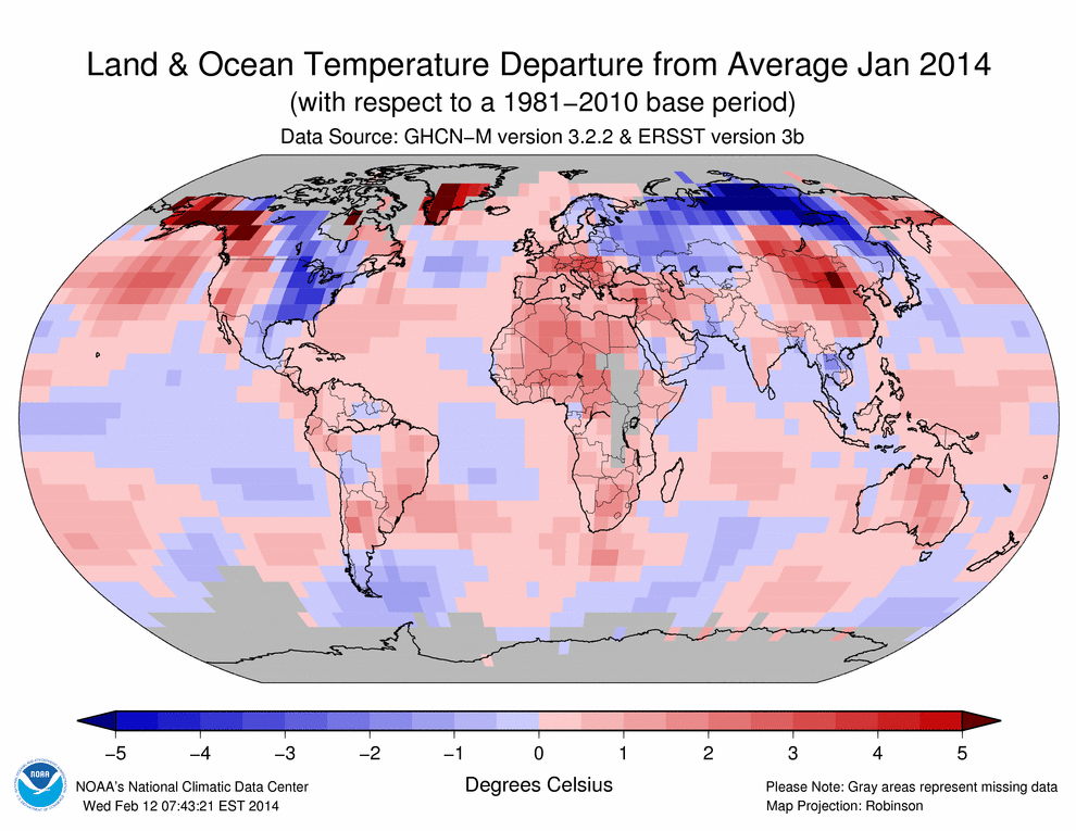
Temperature anomalies and percentiles are shown on the gridded maps below. The anomaly map on the left is a product of a merged land surface temperature (Global Historical Climatology Network, GHCN) and sea surface temperature (ERSST.v3b) anomaly analysis developed by Smith et al. (2008). Temperature anomalies for land and ocean are analyzed separately and then merged to form the global analysis. For more information, please visit NCDC’s Global Surface Temperature Anomalies page. The January 2014 Global State of the Climate report includes percentile maps that complement the information provided by the anomaly maps. These maps on the right provide additional information by placing the temperature anomaly observed for a specific place and time period into historical perspective, showing how the most current month, season, or year-to-date compares with the past.
Temperatures:
In the atmosphere, 500-millibar height pressure anomalies correlate well with temperatures at the Earth’s surface. The average position of the upper-level ridges of high pressure and troughs of low pressure—depicted by positive and negative 500-millibar height anomalies on the January 2014 map—is generally reflected by areas of positive and negative temperature anomalies at the surface, respectively.
January 2014 Blended Land and Sea Surface Temperature Anomalies in degrees Celsius
January 2014 Blended Land and Sea Surface Temperature Percentiles
The combined global land and ocean average temperature during January 2014 was 0.65°C (1.17°F) above the 20th century average. This was the warmest January since 2007 and the fourth highest since records began in 1880. This marks the ninth consecutive month (since May 2013) with a global monthly temperature among the 10 highest for its respective month. The Northern Hemisphere land and ocean surface temperature during January 2014 was also the warmest since 2007 and the fourth warmest since records began in 1880 at 0.75°C (1.35°F) above average. The Southern Hemisphere January 2014 temperature departure of +0.55°C (+0.99°F) was the warmest since 2010 and the fourth warmest January on record.
During January 2014, most of the world’s land areas experienced warmer-than-average temperatures, with the most notable departures from the 1981–2010 average across Alaska, western Canada, Greenland, Mongolia, southern Russia, and northern China, where the departure from average was +3°C (+5.4°F) or greater. Meanwhile, parts of southeastern Brazil and central and southern Africa experienced record warmth with temperature departures between 0.5°C to 1.5°C above the 1981–2010 average, contributing to the highest January Southern Hemisphere land temperature departure on record at 1.13°C (2.03°F) above the 20th century average. This was also the warmest month for the Southern Hemisphere land since September 2013 when temperatures were 1.23°C (2.21°F) above the 20th century average. Some locations across the globe experienced departures that were below the 1981–2010 average. These areas include the eastern half of the contiguous U.S., central Canada, and most of Scandinavia and Russia. The most notable cold anomalies were in Russia, where in some areas the departure from average was 5°C (9°F) below average. Overall, the Northern Hemisphere land surface temperature was 1.17°C (2.11°F) above average—the warmest January since 2007 and the fourth warmest since records began in 1880.
Select national information is highlighted below. (Please note that different countries report anomalies with respect to different base periods. The information provided here is based directly upon these data):
France’s nationally-averaged January 2014 temperature was 2.7°C (4.9°F) above the 1981–2010 average, tying with 1988 and 1936 as the warmest January on record.
Spain experienced its warmest January since 1996 and the third warmest since national records began in 1961, with a temperature of 9°C (48.2°F) or 2°C (3.6°F) above the 1971–2000 average.
The January temperature in Switzerland was 2.4°C (4.3°F) above the 1981–2010 average—the fifth warmest January since national records began 150 years ago.
Austria experienced its fifth warmest January since national records began in 1768. The nationally-averaged temperature was 3.3°C (5.9°F) above the 1981–2010 average. However, in some regions across the southern parts of the country, the temperatures were the highest on record. In Klagenfurt, the temperature departure was 5°C (9°F)—the highest since January 1813.
China, as a whole, recorded an average temperature of -3.4°C (25.9°F) or 1.6°C (2.9°F) above average during January 2014. This was the second highest January value, behind 2002, since national records began in 1961.
In Argentina, persistence of extremely high temperatures across central and northern parts of the country resulted in several locations setting new maximum, minimum, and mean temperature records for the month of January.
Warm temperatures engulfed much of Australia during January 2014. Overall, the national average mean temperature was 0.91°C (1.64°F) above the 1961–1990 average. This was the 12th highest January temperature since national records began in 1910. Regionally, the January 2014 temperature ranked among the top 10 warmest in Queensland, Victoria, and South Australia.
Across the oceans, temperature departures tend to be smaller than across the land surfaces. According to the percentiles map, much-warmer-than-average conditions were present across parts of the Atlantic Ocean, the northeastern and western Pacific Ocean, and parts of the Indian Ocean. Record warmth was observed across parts of the northern Pacific Ocean (south of Alaska), parts of the western Pacific Ocean, south of South Africa, and across parts of the Atlantic Ocean. Overall, the global ocean surface temperature in January was +0.46°C (+0.83°F)—the warmest since 2010 and the seventh warmest on record.
Photo and caption from Milwaukee Journal-Sentinel: Does Lake Michigan’s record low mark beginning of new era for Great Lakes? At least 150 years of rhythmic pulses in Lake Michigan’s water levels appear to have shifted abruptly with loss of winter ice. Photo by Mark Hoffman, Milwaukee Journal-Sentinel
Don’t get complacent, yet. Has enough water fallen in the Great Lakes drainage area in the past six months to change this situation at all? From the New York Times last June:
Water levels in the Great Lakes have been below their long-term averages during the past 14 years, and this winter the water in Lakes Michigan and Huron, the hardest-hit lakes, dropped to record lows, according to the Army Corps of Engineers. Keith Kompoltowicz, the chief of watershed hydrology with the corps’s Detroit district, said that in January “the monthly mean was the lowest ever recorded, going back to 1918.”
While spring rains have helped so far this year, levels in all five Great Lakes are still low by historical standards, so getting through the shallow points in harbors and channels is a tense affair.
It’s not just storms, rising sea levels, and melting glaciers, you know.
The Great Lakes from space. The Great Lakes are the largest glacial lakes in the world. NASA photo via Wikipedia
2012 was one of the 10 warmest years on record globally
The end of weak La Niña, unprecedented Arctic warmth influenced 2012 climate conditions
August 6, 2013
The 2012 State of the Climate report is available online. (Credit: NOAA)
Worldwide, 2012 was among the 10 warmest years on record according to the 2012 State of the Climate report released online today by the American Meteorological Society (AMS). The peer-reviewed report, with scientists from NOAA’s National Climatic Data Center in Asheville, N.C., serving as lead editors, was compiled by 384 scientists from 52 countries (highlights, full report). It provides a detailed update on global climate indicators, notable weather events, and other data collected by environmental monitoring stations and instruments on land, sea, ice, and sky.
“Many of the events that made 2012 such an interesting year are part of the long-term trends we see in a changing and varying climate — carbon levels are climbing, sea levels are rising, Arctic sea ice is melting, and our planet as a whole is becoming a warmer place,” said Acting NOAA Administrator Kathryn D. Sullivan, Ph.D. “This annual report is well-researched, well-respected, and well-used; it is a superb example of the timely, actionable climate information that people need from NOAA to help prepare for extremes in our ever-changing environment.”
Conditions in the Arctic were a major story of 2012, with the region experiencing unprecedented change and breaking several records. Sea ice shrank to its smallest “summer minimum” extent since satellite records began 34 years ago. In addition, more than 97 percent of the Greenland ice sheet showed some form of melt during the summer, four times greater than the 1981–2010 average melt extent.
Temperature in 2012 compared to the 1981-2010 average. Credit: NOAA Climate.gov, based on NCDC data. See more.
The report used dozens of climate indicators to track and identify changes and overall trends to the global climate system. These indicators include greenhouse gas concentrations, temperature of the lower and upper atmosphere, cloud cover, sea surface temperature, sea-level rise, ocean salinity, sea ice extent and snow cover. Each indicator includes thousands of measurements from multiple independent datasets.
Highlights:
Warm temperature trends continue near Earth’s surface: Four major independent datasets show 2012 was among the 10 warmest years on record, ranking either 8th or 9th, depending upon the dataset used. The United States and Argentina had their warmest year on record.
La Niña dissipates into neutral conditions: A weak La Niña dissipated during spring 2012 and, for the first time in several years, neither El Niño nor La Niña, which can dominate regional weather and climate conditions around the globe, prevailed for the majority of the year.
The Arctic continues to warm; sea ice extent reaches record low: The Arctic continued to warm at about twice the rate compared with lower latitudes. Minimum Arctic sea ice extent in September and Northern Hemisphere snow cover extent in June each reached new record lows. Arctic sea ice minimum extent (1.32 million square miles, September 16) was the lowest of the satellite era. This is 18 percent lower than the previous record low extent of 1.61 million square miles that occurred in 2007 and 54 percent lower than the record high minimum ice extent of 2.90 million square miles that occurred in 1980. The temperature of permafrost, or permanently frozen land, reached record-high values in northernmost Alaska. A new melt extent record occurred July 11–12 on the Greenland ice sheet when 97 percent of the ice sheet showed some form of melt, four times greater than the average melt this time of year.
Antarctica sea ice extent reaches record high: The Antarctic maximum sea ice extent reached a record high of 7.51 million square miles on September 26. This is 0.5 percent higher than the previous record high extent of 7.47 million square miles that occurred in 2006 and seven percent higher than the record low maximum sea ice extent of 6.96 million square miles that occurred in 1986.
Sea surface temperatures increase: Four independent datasets indicate that the globally averaged sea surface temperature for 2012 was among the 11 warmest on record. After a 30-year period from 1970 to 1999 of rising global sea surface temperatures, the period 2000–2012 exhibited little trend. Part of this difference is linked to the prevalence of La Niña-like conditions during the 21st century, which typically lead to lower global sea surface temperatures.
Ocean heat content remains near record levels: Heat content in the upper 2,300 feet, or a little less than one-half mile, of the ocean remained near record high levels in 2012. Overall increases from 2011 to 2012 occurred between depths of 2,300 to 6,600 feet and even in the deep ocean.
Sea level reaches record high: Following sharp decreases in global sea level in the first half of 2011 that were linked to the effects of La Niña, sea levels rebounded to reach record highs in 2012. Globally, sea level has been increasing at an average rate of 3.2 ± 0.4 mm per year over the past two decades.
Ocean salinity trends continue: Continuing a trend that began in 2004, oceans were saltier than average in areas of high evaporation, including the central tropical North Pacific, and fresher than average in areas of high precipitation, including the north central Indian Ocean, suggesting that precipitation is increasing in already rainy areas and evaporation is intensifying in drier locations.
Sea ice concentration reached a new record low in mid-September 2012. Credit: NOAA Climate.gov, based on NSIDC data. See more.
Tropical cyclones near average: Global tropical cyclone activity during 2012 was near average, with a total of 84 storms, compared with the 1981–2010 average of 89. Similar to 2010 and 2011, the North Atlantic was the only hurricane basin that experienced above-normal activity.
Greenhouse gases climb: Major greenhouse gas concentrations, including carbon dioxide, methane, and nitrous oxide, continued to rise during 2012. Following a slight decline in manmade emissions associated with the global economic downturn, global CO2 emissions from fossil fuel combustion and cement production reached a record high in 2011 of 9.5 ± 0.5 petagrams (1,000,000,000,000,000 grams) of carbon , and a new record of 9.7 ± 0.5 petagrams of carbon is estimated for 2012. Atmospheric CO2 concentrations increased by 2.1 ppm in 2012, reaching a global average of 392.6 ppm for the year. In spring 2012, for the first time, the atmospheric CO2concentration exceeded 400 ppm at several Arctic observational sites.
Cool temperature trends continue in Earth’s lower stratosphere: The average lower stratospheric temperature, about six to ten miles above the Earth’s surface, for 2012 was record to near-record cold, depending on the dataset. Increasing greenhouse gases and decline of stratospheric ozone tend to cool the stratosphere while warming the planet near-surface layers.
The 2012 State of the Climate report is peer-reviewed and published annually as a special supplement to the Bulletin of the American Meteorological Society. This year marks the 23rd edition of the report, which is part of the suite of climate services NOAA provides to government, the business sector, academia, and the public to support informed decision-making. The full report can be viewed online.
NOAA’s mission is to understand and predict changes in the Earth’s environment, from the depths of the ocean to the surface of the sun, and to conserve and manage our coastal and marine resources. Join us on Facebook, Twitter and our other social media channels.
333 months of worldwide temperature averages above the 20th century average — a kid younger than 27.5 years has never lived through a single month cooler than the 20th century average for that month. We’re well into the second generation of people who know nothing but global warming.
A reasonable and smart person might note that one does not need to be a student of advanced statistics to spot a trend here.
The combined average temperature over global land and ocean surfaces for November was the fifth highest on record for November, at 56.41°F (13.67°C) or 1.21°F (0.67°C) above the 20th century average. The margin of error associated with this temperature is ±0.13°F (0.07°C).
November marked the 36th consecutive November and 333rd consecutive month with a global temperature above the 20th century average. The last below-average temperature November was November 1976 and the last below-average temperature month was February 1985.
The global land temperature was the sixth warmest November on record, at 2.03°F (1.13°C) above the 20th century average. The margin of error is ±0.20°F (0.11°C).
Just a look at the extremes in November should be alarming, especially if you live in the USA.
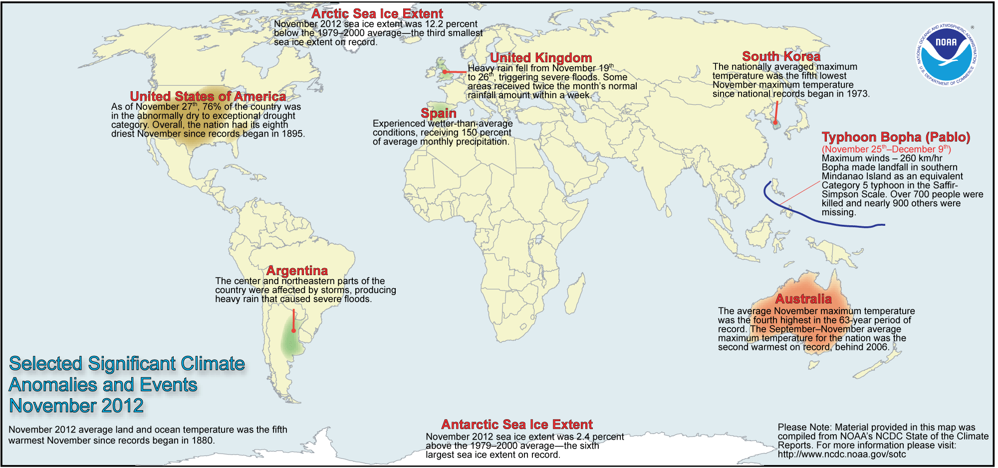
Selected Significant Climate Anomalies and Events, November 2012; click for larger, more-easily-viewed image
More evidence that Michael Mann‘s “hockey stick” graph is vindicated; more evidence that we should not regard James Hansen as we did Cassandra, but should instead heed his warnings.
Myths and Facts about Global Warming (wattsupwiththat.com) (The climate change denialist voice, here in usual form demonstrating how use of red herrings, bait-and-switch, and outright fabrication can make someone appear knowledgeable about a topic, and accurate in foolish criticism.)
Since he prefers a Kim Jong Il-style commenter policy –“only those who flatter the Premier need comment” — Anthony Watts‘s site doesn’t get the pleasure of my visits much, anymore. Consequently I missed the announcement he made last week that he was “suspending” his blog, at least temporarily, until some great news came out.
Anthony Watts, June, 2010. Speaking in Gold Coast, Australia, on a tour searching to find some place on Earth not affected by global warming. (Photo: Wikipedia)
Now the great news is out. I think. Watts may have been right to suspend blogging. He should have kept the suspension longer.
Watts says NOAA‘s temperature measurement in the U.S. is way off, and that if we ignore all the cities, and if we ignore sites that show the greatest increases in temperature over the past century or so, global warming doesn’t look so bad.
This pre-publication draft paper, titled An area and distance weighted analysis of the impacts of station exposure on the U.S. Historical Climatology Network temperatures and temperature trends, is co-authored by Anthony Watts of California, Evan Jones of New York, Stephen McIntyre of Toronto, Canada, and Dr. John R. Christy from the Department of Atmospheric Science, University of Alabama, Huntsville, is to be submitted for publication.
Wait a minute. “Prepublication draft paper?” ” . . . to be submitted for publication?”
Yes, Dear Reader, that claxon you hear is your and my Hemingway III Solid Gold [Excrement] Detectors™ going off. It may be a false alarm, but still — isn’t this how bogus science is done, isn’t this what Robert Park warns us about? Indeed, in the Seven Warning Signs of Bogus Science, Park says to pay attention to key indicators: “1. The discoverer pitches the claim directly to the media.” It is, indeed, a press release from Watts, about a paper he hopes to get through the peer review process at some point in the future — but it has not yet been pitched to the science journals. (Yes, that’s also one of the Seven Warning Signs of Bogus History . . . one discipline at a time, please.)
Same old stuff, new day. Watts has been arguing for years that NOAA’s temperature measurements err, but after the Berkeley Earth Surface Temperatures (BEST) Project determined that warming exists, even using Watts’s modified measurements and accounting for his claimed errors, some of us hoped Watts might turn to blogging about science, instead.
No, Watts turned to finding a hint of a methodology that might support his preconceived notions. He found one.
So, Watts’s big announcement is that he’s found a methdology which favors his criticisms of NOAA; so we should ignore temperature readings from cities, because cities are hot, and we should ignore temperature readings from suburbs of cities, because suburbs are warm; and if we do that, then warming in the U.S. doesn’t look so bad.
Were I allowed to ask questions at Watts’s blog, I’d ask why we should ignore warming in cities, because are they not part of the planet? Oh, well.
The Twitter version:
Watts: Ignore city temps (hot!) and ‘burbs (warm!), temps on farms don’t show so much global warming! Oops – did we say that before?
Anthony, how about you suspend your blog until you get the paper accepted at a good journal? Make sure you got the numbers right . . .
2011 saw 14 severe weather events that caused more than $1 billion in damage each. The pre-Halloween snow disaster may push the total up to 15 such events. NOAA is calling these billion-dollar-plus events “climate disasters.”
On top of the year 2011’s rating in the top 10 of warmest years on record, the sheer number of expensive weather extremes powerfully suggest that global warming already costs Americans billions of dollars in damage, lost production and disease.
NOAA announces two additional severe weather events reached $1 billion damage threshold, raising 2011’s billion-dollar disaster count from 12 to 14 events
January 19, 2012
Selected Annual Climate Records for 2011 - Green dots show the wettest, yellow dots the driest, red dots the warmest and blue dots the coolest records. Click image for high resolution version from NOAA (NOAA image)
According to NOAA scientists, 2011 was a record-breaking year for climate extremes, as much of the United States faced historic levels of heat, precipitation, flooding and severe weather, while La Niña events at both ends of the year impacted weather patterns at home and around the world.
NOAA’s annual analysis of U.S. and global conditions, conducted by scientists at NOAA’s National Climatic Data Center, reports that the average temperature for the contiguous U.S. was 53.8 degrees F, 1.0 degree F above the 20th century average, making it the 23rd warmest year on record. Precipitation across the nation averaged near normal, masking record-breaking extremes in both drought and precipitation.
On a global scale, La Niña events helped keep the average global temperature below recent trends. As a result, 2011 tied with 1997 for the 11th warmest year on record. It was the second coolest year of the 21st century to date, and tied with the second warmest year of the 20th century.
From extreme drought, heat waves and floods to unprecedented tornado outbreaks, hurricanes, wildfires and winter storms, a record 14 weather and climate disasters in 2011 each caused $1 billion or more in damages — and most regrettably, loss of human lives and property. Click image for high resolution version. (NOAA image)
Tropical Storm Lee, which made landfall on the Gulf Coast on September 2, caused wind and flood damage across the Southeast, but considerably more damage to housing, business and infrastructure from record flooding across the Northeast states, especially Pennsylvania and New York. The storm occurred in an area that had experienced high rainfall from Hurricane Irene barely a week earlier.
Tropical Storm Lee, on September 3, 2011 - Image via Wikipedia
A Rockies and Midwest severe weather outbreak, which occurred July 10-14, included tornadoes, hail and high winds. Much of the damage was from wind, hail, and flooding impacts to homes, business, and agriculture.
Together, these two events resulted in the loss of 23 lives (21 from Tropical Storm Lee, 2 from the Rockies/Midwest outbreak).
Nationally
Warmer-than-normal temperatures were anchored across the South, Mid-Atlantic and the Northeast. Delaware had its warmest year on record, while Texas had its second warmest year on record. The U.S. has observed a long-term temperature increase of about 0.12 degrees F per decade since 1895.
Summer (June-August) 2011 was the second warmest on record for the Lower 48, with an average temperature of 74.5 degrees F, just 0.1 degree F below the record-warm summer of 1936. The epicenter of the heat was the Southern Plains, where Louisiana, New Mexico, Oklahoma and Texas all had their warmest summer on record. The 3-month average temperatures for both Oklahoma (86.9 degrees F) and Texas (86.7 degrees F) surpassed the previous record for warmest summer in any state.
With the exception of Vermont, each state in the contiguous U.S. had at least one location that exceeded 100 degrees F. Summertime temperatures have increased across the U.S. at an average rate of 0.11 degrees F per decade. Much of this trend is due to increases in minimum temperatures (“overnight lows”), with minimum temperature extremes becoming increasingly commonplace in recent decades.
Despite a “near normal” national precipitation average, regional precipitation outcomes varied wildly. Texas, ravaged by exceptional drought for most of 2011, had its driest year on record. In contrast, seven states in the Ohio Valley and Northeast — Connecticut, Indiana, Kentucky, New Jersey, New York, Ohio, and Pennsylvania — had their wettest year on record.
The past nine years have been particularly wet across the Northeast region – since 2003, the annual precipitation for the region is 48.96 inches, 7.88 inches above the 20th century average. Precipitation averaged across the U.S. is increasing at a rate of about 0.18 inches per decade.
Precipitation extremes and impacts were most prevalent during spring (March – May) 2011. Across the northern U.S., ten states were record wet, and an additional 11 states had spring precipitation totals ranking among their top ten wettest. These precipitation extremes, combined with meltwater from a near-record snow pack, contributed to historic flooding along several major rivers across the central United States.
Meanwhile, drought rapidly intensified in the southern Plains, where Texas had only 2.66 inches of precipitation, its driest spring on record. This led to record breaking drought and wildfires, which devastated the southern Plains. Following 2010, during which drought across the country was nearly erased, the 12 percent of the continental U.S. in the most severe category of drought (D4) during July 2011 was the highest in the U.S. Drought Monitor era (1999-2011).
The spring brought a record breaking tornado season to the United States. Over 1,150 tornadoes were confirmed during the March-May period. The 551 tornado-related fatalities during the year were the most in the 62-year period of record. The deadliest tornado outbreak on record (April 25-28th) and the deadliest single tornado (Joplin, Missouri) contributed to the high fatality count.
Globally
This year tied 1997 as the 11th warmest year since records began in 1880. The annual global combined land and ocean surface temperature was 0.92 degrees F above the 20th century average of 57.0 degrees F. This marks the 35th consecutive year, since 1976, that the yearly global temperature was above average. The warmest years on record were 2010 and 2005, which were 1.15 degrees F above average.
Separately, the 2011 global average land surface temperature was 1.49 degrees F above the 20th century average of 47.3 degrees F and ranked as the eighth warmest on record. The 2011 global average ocean temperature was 0.72 degrees F above the 20th century average of 60.9 degrees F and ranked as the 11th warmest on record.
Including 2011, all eleven years of the 21st century so far (2001-2011) rank among the 13 warmest in the 132-year period of record. Only one year during the 20th century, 1998, was warmer than 2011.
La Niña, which is defined by cooler-than-normal waters in the eastern and central equatorial Pacific Ocean that affects weather patterns around the globe, was present during much of 2011. A relatively strong phase of La Niña opened the year, dissipated in the spring before re-emerging in October and lasted through the end of the year. When compared to previous La Niña years, the 2011 global surface temperature was the warmest observed.
The 2011 globally-averaged precipitation over land was the second wettest year on record, behind 2010. Precipitation varied greatly across the globe. La Niña contributed to severe drought in the Horn of Africa and to Australia’s third wettest year in its 112-year period of record.
Arctic sea ice extent was below average for all of 2011, and has been since June 2000, a span of 127 consecutive months. Both the maximum ice extent (5.65 million square miles on March 7th) and the minimum extent (1.67 million square miles on September 9th) were the second smallest of the satellite era.
For the second year running, NCDC asked a panel of climate scientists to determine and rank the year’s ten most significant climate events, for both the United States and for the planet, to include record drought in East Africa and record flooding in Thailand and Australia. The results are at http://www.ncdc.noaa.gov/climate-monitoring.
Scientists, researchers and leaders in government and industry use NOAA’s monthly and annual reports to help track trends and other changes in the world’s climate. This climate service has a wide range of practical uses, from helping farmers know what and when to plant, to guiding resource managers’ critical decisions about water, energy and other vital assets.
NOAA’s mission is to understand and predict changes in the Earth’s environment, from the depths of the ocean to the surface of the sun, and to conserve and manage our coastal and marine resources. Join us on Facebook, Twitter and our other social media channels.
Denialist bedbugs complain that there is no definition of “climate disaster” offered from the agency. (Denialists are dictionary-challenged?)
The upper layer of the world’s ocean has warmed since 1993, indicating a strong climate change signal, according to a new study. The energy stored is enough to power nearly 500 100-watt light bulbs per each of the roughly 6.7 billion people on the planet.
“We are seeing the global ocean store more heat than it gives off,” said John Lyman, an oceanographer at NOAA’s Joint Institute for Marine and Atmospheric Research, who led an international team of scientists that analyzed nine different estimates of heat content in the upper ocean from 1993 to 2008.
From NOAA: John Lyman (left) holds an expendable bathythermograph or XBT, a device that was dropped from ships to obtain temperature. Gregory Johnson (right) holds an ARGO Float, an autonomous, free-floating ocean device that collects a variety of data, including temperature. (NOAA photo, 2010)
The team combined the estimates to assess the size and certainty of growing heat storage in the ocean. Their findings will be published in the May 20 edition of the journal Nature. The scientists are from NOAA, NASA, the Met Office Hadley Centre in the United Kingdom, the University of Hamburg in Germany and the Meteorological Research Institute in Japan.
“The ocean is the biggest reservoir for heat in the climate system,” said Josh Willis, an oceanographer at NASA’s Jet Propulsion Laboratory and one of the scientists who contributed to the study. “So as the planet warms, we’re finding that 80 to 90 percent of the increased heat ends up in the ocean.”
A warming ocean is a direct cause of global sea level rise, since seawater expands and takes up more space as it heats up. The scientists say that this expansion accounts for about one-third to one-half of global sea level rise.
Combining multiple estimates of heat in the upper ocean – from the surface to about 2,000 feet down – the team found a strong multi-year warming trend throughout the world’s ocean. According to measurements by an array of autonomous free-floating ocean floats called ARGO as well as by earlier devices called expendable bathythermographs or XBTs that were dropped from ships to obtain temperature data, ocean heat content has increased over the last 16 years.
The team notes that there are still some uncertainties and some biases.
“The XBT data give us vital information about past changes in the ocean, but they are not as accurate as the more recent Argo data,” said Gregory Johnson, an oceanographer at NOAA’s Pacific Marine Environmental Laboratory. “However, our analysis of these data gives us confidence that on average, the ocean has warmed over the past decade and a half, signaling a climate imbalance.”
Data from the array of Argo floats – deployed by NOAA and other U.S. and international partners – greatly reduce the uncertainties in estimates of ocean heat content over the past several years, the team said. There are now more than 3,200 Argo floats distributed throughout the world’s ocean sending back information via satellite on temperature, salinity, currents and other ocean properties.
NOAA’s mission is to understand and predict changes in the Earth’s environment, from the depths of the ocean to the surface of the sun, and to conserve and manage our coastal and marine resources. Visit us on Facebook.
Note: Full name of the paper is Robust Warming of the Global Upper Ocean. Authors are John M. Lyman, Joint Institute for Marine and Atmospheric Research, University of Hawaii at Manoa and NOAA/Pacific Marine Environmental Laboratory, Seattle; Simon A. Good, Met Office Hadley Centre; Viktor V. Gouretski Klima Campus, University of Hamburg; Masayoshi Ishii, Climate Research Department, Meteorological Research Institute, Japan; Gregory C. Johnson, NOAA/Pacific Marine Environmental Laboratory, Seattle; Matthew D. Palmer, Met Office Hadley Centre; Doug M. Smith, Met Office Hadley Centre; and Josh K. Willis, NASA Jet Propulsion Laboratory, Pasadena, Calif.
From NASA: The international science team analyzed nine different estimates of heat content in the upper ocean, based on ocean temperature data from a global array of more than 3,200 Argo free-floating profiling floats and longer data records from expendable bathythermographs dropped from ships. Image credit: International Argo Project
The world’s combined global land and ocean surface temperature made last month the warmest March on record, according to NOAA. Taken separately, average ocean temperatures were the warmest for any March and the global land surface was the fourth warmest for any March on record. Additionally, the planet has seen the fourth warmest January – March period on record.
NOAA’s (National Oceanographic and Atmospheric Administration) report points out — again — that local weather is not world climate:
The combined global land and ocean average surface temperature for March 2010 was the warmest on record at 56.3°F (13.5°C), which is 1.39°F (0.77°C) above the 20th century average of 54.9°F (12.7°C).
The worldwide ocean surface temperature was the highest for any March on record –1.01°F (0.56°C) above the 20th century average of 60.7°F (15.9°C).
Separately, the global land surface temperature was 2.45°F (1.36°C) above the 20th century average of 40.8 °F (5.0°C) — the fourth warmest on record. Warmer-than-normal conditions dominated the globe, especially in northern Africa, South Asia and Canada. Cooler-than-normal regions included Mongolia and eastern Russia, northern and western Europe, Mexico, northern Australia, western Alaska and the southeastern United State
News continues to roll in about the investigations of the stealing of e-mails from England’s Hadley Climate Research Unit (CRU), and the news is that the scientists who documented global warming were accurate and honest. Alas, such reports do not slow the anti-science denialist mob provocateurs.
So, we have assurance that the scientists are honest and hardworking. Their hard work shows the planet warming, and the most likely proximate cause of the warming is human-caused effluents.
Did your newspaper cover the story? How will denialists react? Will anyone really notice?
Or, until that account is unsuspended by the forces supporting Donald Trump: Follow @FillmoreWhite, the account of the Millard Fillmore White House Library
We've been soaking in the Bathtub for several months, long enough that some of the links we've used have gone to the Great Internet in the Sky.
If you find a dead link, please leave a comment to that post, and tell us what link has expired.
Thanks!
Retired teacher of law, economics, history, AP government, psychology and science. Former speechwriter, press guy and legislative aide in U.S. Senate. Former Department of Education. Former airline real estate, telecom towers, Big 6 (that old!) consultant. Lab and field research in air pollution control.
My blog, Millard Fillmore's Bathtub, is a continuing experiment to test how to use blogs to improve and speed up learning processes for students, perhaps by making some of the courses actually interesting. It is a blog for teachers, to see if we can use blogs. It is for people interested in social studies and social studies education, to see if we can learn to get it right. It's a blog for science fans, to promote good science and good science policy. It's a blog for people interested in good government and how to achieve it.
BS in Mass Communication, University of Utah
Graduate study in Rhetoric and Speech Communication, University of Arizona
JD from the National Law Center, George Washington University


 Posted by Ed Darrell


