Tommy Caldwell and Kevin Jorgeson on January 14 completed their free-climb ascent of the 3,000-foot Dawn Wall on El Capitan in Yosemite National Park — labeled the toughest free climb in the world.
Wow. Just wow.
The path up, the Dawn Wall on El Capitan. San Francisco Chronicle graphic by John Blanchard, on a photo by Nate Ptacek/Patagonia
NBC News correspondent Hallie Jackson posted this photo on her Twitter feed, a shot from NBC photographer Scot Kilian:
@HallieJackson: Incredible shot from NBC’s Scott Kilian: that tiny dot of light on side of #DawnWall is where the climbers slept.
It’s a long exposure, enough that the stars brighten the black sky, but not quite so much that the stars become streaks on the photo. Long enough that the lights used by Tommy Caldwell and Kevin Jorgeson register on the CMOS (I’m assuming no film here).
Incredibly, their tents are pitched upon the rock, where mountain goats and cliff-dwelling birds fear to tread. It’s very much a vertical sheet of almost smooth rock.
And it’s a great photo. In these particularly troubled times, any light shining on human cooperation to achieve great things becomes a beacon.
Wilderness Society Tweeted: Stars over Yosemite’s El Capitan (in honor of @kjorgeson & @tommycaldwell1). Have a good night! (Photo by Justin Kern, flickr)
Actually, this photo probably is not from the past few days, when Kevin Jorgeson and Tommy Caldwell worked to free climb the rock — but the Milky Way is there if they care to look!
Not just the whole world is watching — the whole universe shines down.
(Have you been following their climbing exploits?)
More:
Follow the climbers on Twitter, @kjorgeson and @tommycaldwell1
Yosemite National Park, Facebook site: About forty members of U.S. 6th Cavalry, Troop F, shown mounted on, or standing beside their horses, and lined up atop and beside the Fallen Monarch tree in the Mariposa Grove of Giant Sequoias, Yosemite, 1899.
Giant sequoia trees can be found only in the United States, and only in or near the Sierra Mountains in California.
How massive are they? The tree above, with the 6th Cavalry’s F Troop posing on and around it with their horses, is 26 feet in diameter at its base, where it fell, and 285 feet long, Redwood doesn’t rot like other woods. The tree is still there, today, looking much like it did 115 years ago (Comments on Yosemite NP photo).
The Fallen Monarch, in Mariposa Grove, in 1907:
Fallen Monarch, Mariposa Grove of Yosemite NP, in 1907, with a stage coach and team of six horses posing on top.
When did the tree fall? Hundreds of years ago, perhaps?
Yosemite Falls is the tallest waterfall in North America, and is a powerful presence in Yosemite Valley. From winter ice to spring flood to autumn dryness, this magnificent waterfall is a dynamic force of nature.
National Park Service photo of Upper Yosemite Falls
U.S. President Theodore Roosevelt (left) and nature preservationist John Muir, founder of the Sierra Club , on Glacier Point in Yosemite National Park in 1903. In the background: Upper and lower Yosemite Falls. (Photo credit: Wikipedia)
73,117
Spread the word; friends don't allow friends to repeat history.
USDA/Flickr photo via Mother Jones: A National Park Service fire crew builds a sprinkler system around a grove of sequoias. USDA/Flickr
It’s a rolling tragedy, in time-lapse. Fire always offers a chance at beauty, if we don’t think about the destruction the fire wreaks.
A lot of cameras around Yosemite, and some were set to do time-lapse photos of the recent Rim Fire. One hopes there is some academic value to these films, perhaps in demonstrating how the diurnal rhythms of the atmosphere changes the behavior of fire (notice how smoke often changes directions at sunset, and then at sunrise, and back again).
All that smoke. Much of it was living plant material just a few weeks ago, and we watch it turned to tiny particles and gases, and spread by the winds.
More information from the filmmakers and posters:
Published on Aug 28, 2013
Time-lapse photography shows various perspectives of the 2013 Rim Fire, as viewed from Yosemite National Park. The first part of this video is from the Crane Flat Helibase. The fire [was] . . .burning in wilderness and . . . not immediately threatening visitors or employees. The second half of the video is from Glacier Point, showing Yosemite Valley, and how little the smoke from the fire has impacted the Valley.
In this next piece, you’ll see footage of fire fighting operations, including a back-burn, and helicoptering of supplies to firefighters on the front lines. It’s the non-time-lapse version, with wildtrack sound.
Published on Sep 7, 2013
Fire crews in Yosemite conducted firing operations along the Tioga Road this week to provide a buffer of protection from the Rim Fire. As you can see in this video, the fire mostly burns debris on the forest floor rather than the trees. It’s only when the forest floor accumulates too much debris or too many young trees that a small fire like this gets hot enough to torch mature trees and spread from treetop to treetop.
Later in the video, we give you a behind-the-scenes peek at Yosemite’s Helicopter 551 ferrying supplies from the Crane Flat helibase.
The timelapse, from August, has over a million-and-a-half views on YouTube; the non-timelapse, a few weeks later, has fewer than 6,000 views, as I write this. Time-lapse is very popular.
(This is not a place to bolster creationist ideas. This is real science, looking at God’s handiwork first hand.)
A North Carolina university makes field trips to Yosemite? I’d love to take that class!
Watching this film, you get a sense of how important it can be to the education of our children to travel in the summers, to take vacations to our National Parks, and to places like Yosemite.
Where are you taking your kids this summer? Kids, where are you going?
Enjoy it. Geology lessons are often fun, and this one, on film, is more fun than most.
Horsetail Fall flows over the eastern edge of El Capitan in Yosemite Valley. It’s a small waterfall that many people don’t notice, but it has gained popularity as more and more people have noticed it can glow orange during sunset in mid to late February. The most popular place to see Horsetail Fall seemingly afire is El Capitan picnic area, west of Yosemite Lodge and east of El Capitan (see map below). The “firefall” effect generally happens during the second half of February. A clear sky is necessary for the waterfall to glow orange. Photo: Bethany Gediman, NPS
People living close to National Parks are lucky to do so; people who work in them luckier still, in the lifetime sweepstakes for seeing breathtaking sites. NPS employee (Ranger?) Bethany Gediman caught this image of Horsetail Fall in Yosemite National Park.
Yosemite’s vast acreage and remote location protect some of the darkest night skies in the country. Astronomers, photographers and city dwellers flock to the park to take advantage of this unique opportunity to view planets, stars, and galaxies.
For classroom use, some topics and questions to pursue:
For geography, where is Yosemite N.P.? Flying commercially, which airport is the best to get to the park?
President Teddy Roosevelt and conservationist John Muir pose at Overhanging Rock at the top of Glacier Point, near which the men camped in a hollow and awoke to five inches of snow in 1903. National Park Service image
Map reading and orientation: In the time-lapse sequences, you can frequently see lights streaking across the sky. Those are commercial airliners — can you tell what airport they are headed to, or from? Can you tell which ones are coming, which going?
Science: What star formations do you see in these photographs that you can see from your house? What star formations are not visible from your house?
Government: Who signs the checks that pay the rangers pictured in the film? For which agency do the work, in which branch of which government?
People in the film discuss light pollution from nearby cities. Is there an agency in the federal government who has jurisdiction over light pollution? How about an agency in the state government? What are the rules on light pollution for cities around Yosemite?
Can you identify the landmarks, the cliffs, rocks, mountains and rivers, portrayed in the film? (Students might use a USGS topographical map, California state tourist promotion maps and websites, National Park Service databases, Google Earth, Google, and a wide variety of other sources.
Who was president of the U.S. when Yosemite was set aside as a National Park, and what were the controversies surrounding it?
Who lived in Yosemite, if anyone, before the Spanish missions were established in California? When were the missions established? How did the U.S. gain possession of the Yosemite Valley?
Spread the word; friends don't allow friends to repeat history.
Clearly I need to intern with Shawn Reeder. His piece on Yosemite shows the natural objects of beauty in their best lights, over and over: “Yosemite Range of Light.”
The two-year project, Yosemite Range of Light, uses nearly 7,000 high-resolution still photos to create an inspiring vision of light and granite, capturing rolling cloud formations and the rainbow-lit waterfalls of Yosemite.
Reeder first came to Yosemite after winning a local waiter contest where he grew up in Maryland. First prize was a trip to Napa Valley wine-country, but the 18-year-old convinced the prize committee to offer a change of venue. Choosing Yosemite as his destination instead, he brought along his best friend, who happened to have a camera. . . .
“I came out for a week and I did my first backpacking trip ever. We hiked to the top of Half Dome via the cables, which was an incredible experience. We hiked the whole South-Rim Trail from Glacier Point to Tunnel View. It to
Panorama of view of Yosemite Valley including Half Dome and Diving Board as seen from Glacier Point in Yosemite National Park. (Photo credit: Wikipedia)
Spread the word; friends don't allow friends to repeat history.
Details on the film, and how to track down the artists and see more, from Project Yosemite’s Vimeo site:
A collaborative project by Sheldon Neill and Colin Delehanty. What started as an idea turned into an ongoing adventure to timelapse Yosemite in an extreme way.
We were complete strangers before it all started, but after we met on Vimeo our idea came into sight, and then began the challenge to make numerous trips to YNP where we would capture the beautiful landscape it offers for visitors every year.
We invite you to watch our video in hopes you’ll witness Yosemite like never before.
Yosemite HD
This video is a collaboration between Sheldon Neill and Colin Delehanty. All timelapses were shot on the Canon 5D Mark II with a variety of Canon L and Zeiss CP.2 Lenses.
This whole project has been an amazing experience. The two of us became friends through Vimeo and explored a shared interest in timelapsing Yosemite National Park over an extended period of time. We’d like to expand this idea to other locations and would appreciate any suggestions for a future project.
Our hearts go out to the families of Markus Praxmarer who lost his life while climbing Half Dome on September 19th, 2011 and Ranger Ryan Hiller, who was crushed by a tree January 22nd 2012. They will be missed. (A photo of Ranger Ryan Hiller can be found to the right, above the statistics counter)
Generalized geologic map of the Yosemite area. (USGS image) (Photo credit: Wikipedia)
Yosemite National Park is spectacular, and much photographed than other great natural places of beauty. How much does it benefit from being in California, closer to many people with good cameras and great photographic skills, to an extent that more distant, spectacular parks like Glacier N.P., Yellowstone N.P and Big Bend N.P. do not benefit? How does that affect management of the parks? How does that affect how people view their own local adventure areas?
John Muir’s place in American history endures constant assault. Not only did businessmen and politicians of his own day find Muir’s policies anathema to their hopes of profiting from the destruction of the American wild, so today do we hear that profits cannot be had without the rape of the environment.
Muir knew better, and so should you!
On July 19, 1869 — in the middle of the administration of U. S. Grant, Muir began his journals on the beauty of life in the Sierras, to be published 42 years later as My First Summer in the Sierra.
It should be required reading in more American classrooms:
John Muir
Watching the daybreak and sunrise. The pale rose and purple sky changing softly to daffodil yellow and white, sunbeams pouring through the passes between the peaks and over the Yosemite domes, making their edges burn; the silver firs in the middle ground catching the glow on their spiry tops, and our camp grove fills and thrills with the glorious light. Everything awakening alert and joyful…John Muir, Entry for “July 19“ from My First Summer in the Sierra, 1911. “California As I Saw It”: First-Person Narratives of California’s Early Years, 1849-1900
On July 19, 1869, naturalist John Muir set pen to paper to capture his experience of awakening in the Sierra Nevada Mountains of California. Published in 1911, My First Summer in the Sierra is based on Muir’s original journals and sketches of his 1869 stay in the vicinity of the Yosemite Valley. His journal tracks his three-and-a-half-month visit to the Yosemite region and his ascent of Mt. Hoffman and other Sierra peaks. Along the way, he describes the flora and fauna as well as the geography and geology of the area.
Muir immigrated from Scotland to Wisconsin as a child. He attended the University of Wisconsin and began working as a mechanical inventor. After an 1867 industrial accident nearly blinded him, he abandoned his career as an inventor to work as a naturalist.
An early defender of the environment, Muir in 1876 advocated adoption of a federal forest conservation program. His popular articles and books describing Yosemite’s natural wonders inspired public support for the establishment of Yosemite National Park in 1890 and expansion of the park in 1906. At the same time, Muir continued to work and write as a serious scientist whose fieldwork in botany and geology enabled him to make lasting contributions. Alaska’s Muir Glacier is named for him. In 1892, Muir co-founded the as an association explicitly dedicated to wilderness preservation and served until 1914 as its first president, shaping it into an organization whose leadership in political advocacy for protection of the natural world continues to this day.
The popularity of President Theodore Roosevelt’s groundbreaking conservation program owed much to Muir’s writing. In 1903 Roosevelt and Muir visited the Yosemite region together. In 1908, Roosevelt issued a presidential proclamation establishing the Muir Woods National Monument in Marin County, California, in Muir’s honor. Muir died six years later. Although sorrow and disappointment at his failure to save Hetch Hetchy Valley from becoming a reservoir for San Francisco may well have contributed to his death, Muir had succeeded more than any other single individual in establishing the preservation of wild nature as a major American cultural and political value. The clarity of his vision and the eloquence of his writing continue to inspire environmentalists throughout the world.
Learn more about John Muir and the conservation movement in American Memory:
Visit the ‘s . This fascinating presentation provides a wealth of information and links, including many photographs, a wide selection of electronic texts written by and about John Muir, and sound clips of songs written about or inspired by Muir’s work. Yosemite National Park Wildflowers,
Yosemite National Park,
California. American Landscape and Architectural Design, 1850-1920
Search on Yosemiteor the name of other national parks in the following collections to see more images of America’s natural wonders:
For access to current environmental protection bills under consideration in the U.S. House of Representatives and the Senate, visit THOMAS and browse major legislation classified by topic using terms such as environmental protection or public lands.
Spread the word; friends don't allow friends to repeat history.
Our Scout Troop readies for two summer camp excursions this summer, and Kathryn and I hope to get out somewhere not drought stricken for at least a weekend. Generally we tack on a whitewater river run on the Scout trips, if we can find a good one for reasonable price. Safety instructions always include the solid order to wear a Personal Flotation Device (PFD) at all times. We have a few adult leaders trained in Safety Afloat, and we work to have the Scouts up to “swimmer” or “lifesaver” ability for the trips.
It’s a good idea to review all the rules for safety near water in the great outdoors.
The good video crew at Yosemite National Park posted this dramatic video story — please watch, and heed the warnings. Doesn’t matter how well you swim, if you get pinned underwater by a powerful flow — and they are all powerful — you’re in trouble. This story has a happy ending with chastened hikers who learned uncharted short cuts may not be a good idea. For nearly a score of people in Yosemite NP the turnout was not wonderful, in the last ten years.
In Texas, drownings take about a hundred lives a year, averaging 81 child drownings each year: “An average of 81 children drowned each year since DFPS [Department of Family Protective Services] began tracking these deaths in 2005. DFPS identified 76 water fatalities in 2005, 70 in 2006, 63 in 2007, 82 in 2008, 113 in 2009 and 84 in 2010, and 79 in 2011 as of August 31, 2011.” [If you can find figures including adult drownings, please let us know in the comments.]
Please watch, and pass along to anyone you know who will be hiking this year.
Text from the filmmakers:
Sixteen people died in Yosemite’s rivers and creeks between 2002 and 2011. Water in Yosemite is more dangerous than it looks, and stories like Matthew’s are a common occurrence.
Go outside, have great fun, see America. Be careful when you do.
Spread the word; friends don't allow friends to repeat history.
Nature Notes #16 from the good people at Yosemite National Park: Sky Islands.
Throughout the Sierra Nevada, high flat plateaus are found at elevations around twelve and thirteen thousand feet. These isolated sky islands are the home to unique plant communities that are found nowhere else.
Or, until that account is unsuspended by the forces supporting Donald Trump: Follow @FillmoreWhite, the account of the Millard Fillmore White House Library
We've been soaking in the Bathtub for several months, long enough that some of the links we've used have gone to the Great Internet in the Sky.
If you find a dead link, please leave a comment to that post, and tell us what link has expired.
Thanks!
Retired teacher of law, economics, history, AP government, psychology and science. Former speechwriter, press guy and legislative aide in U.S. Senate. Former Department of Education. Former airline real estate, telecom towers, Big 6 (that old!) consultant. Lab and field research in air pollution control.
My blog, Millard Fillmore's Bathtub, is a continuing experiment to test how to use blogs to improve and speed up learning processes for students, perhaps by making some of the courses actually interesting. It is a blog for teachers, to see if we can use blogs. It is for people interested in social studies and social studies education, to see if we can learn to get it right. It's a blog for science fans, to promote good science and good science policy. It's a blog for people interested in good government and how to achieve it.
BS in Mass Communication, University of Utah
Graduate study in Rhetoric and Speech Communication, University of Arizona
JD from the National Law Center, George Washington University


 Posted by Ed Darrell
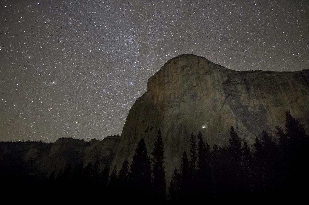


 and n...")


