August 24, 2015
Much as the GOP Caucus and other climate-change deniers, Roman officials in Pompeii and Herculaneum refused to be alarmed at the ground shaking, and obvious eruptions from Mount Vesuvius, on August 24, 79 C.E.
In the past week we have earthquakes in California, Nepal, British Columbia, and other places. The old Earth keeps rumbling.
Oddly, we now pay more attention to earthquakes than to other things that can cause greater, rolling disasters.
Santayana’s Ghost wonders if we ever learn from history.

Vesuvius, asleep for now (2013). National Geographic photo by Robert Clark
More:

Yes, this is mostly an encore post. Fighting ignorance requires patience.
Spread the word; friends don't allow friends to repeat history.
 Leave a Comment » |
  Archaeology, Disasters, earthquakes, Geography - Physical, geology, Global warming, Science, Volcanoes | Tagged: 79 AD, 79 CE, Disasters, earthquakes, geology, Global warming, Pompeii, Rome, Vesuvius, Volcanoes |
  Permalink
 Posted by Ed Darrell
January 7, 2015
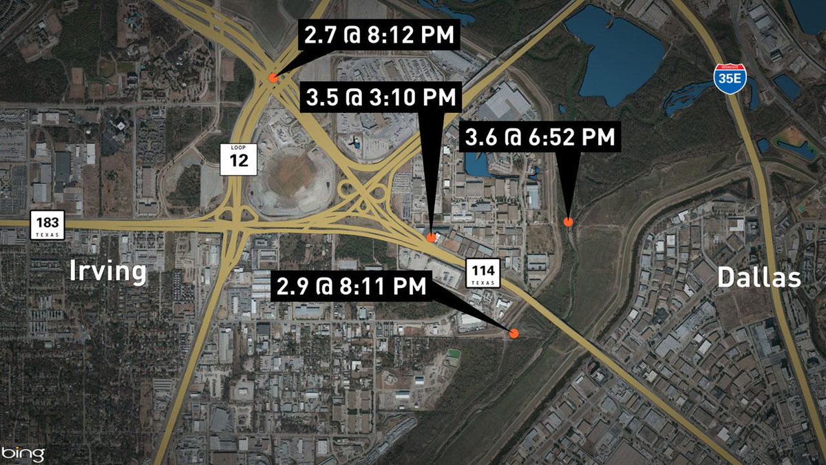
WFAA Channel 8 map of four quakes confirmed by 10:00 p.m. news casts, showing how close the quakes are in proximity to each other and the site of the old Cowboys Football Stadium.
This Tweet from our local NBC TV affiliate sums it up nicely.
North Texas shook yesterday — not big quakes, but a bunch of ’em — and that doesn’t sit well with Texas oil executives, since it seems likely gas and oil drilling, especially hydraulic fracturing (fracking), and especially waste-water reinjection seem to be causes.
I grew up in Utah. We had quakes you could feel, at least weekly. Our home sat less than a mile west of the Wasatch Fault. Many mornings my mother would stand drinking her coffee, looking over the stove and out our kitchen window at Mt. Timpanogos, remarking on the earthquakes. Most often we couldn’t feel them, but the power and telephone lines that slashed through our $10 million view of the mountain would dance in sine waves during quakes. It was pretty cool.
Along the more famous faults, one rarely comes on more than a couple of quakes a day.
Dallas — more accurately, Irving — is far away from most major faults, and rarely has more than a couple of quakes a year in recent human history.
So this swarm of quakes makes news!
WTVT Channel 11 (CBS) reported:
DALLAS (CBSDFW.COM/AP) – Nine earthquakes, three of them with a 3-point magnitude or greater, rocked North Texas Tuesday into early Wednesday, knocking items off walls, causing cracks to appear in ceilings and generally rattling nerves across the region.
“The last one really shook,” said CBS 11 anchor and reporter Ken Molestina, who felt the the earth move in the White Rock Lake area of Dallas.
The latest quake, reported just before 1 a.m. Wednesday, measured in at a 3.1 magnitude, and was centered near the convergence of State Highway 114, Loop 12, and the Airport Freeway near the old Texas Stadium site in Irving.
Others felt the temblor in the Uptown area of Dallas and as far away as Bedford and Mesquite.
Here’s a list of the quakes in order of when they happened:
7:37 a.m. 2.3 magnitude
3:10 p.m. 3.5 magnitude
6:52 p.m. 3.6 magnitude
8:11 p.m. 2.9 magnitude
8:12 p.m. 2.7 magnitude
9:54 p.m. 1.7 magnitude
10:05 p.m. 2.4 magnitude
11:02 PM 1.6 magnitude
12:59 AM 3.1 magnitude
Rafael Abreu, a geophysicist with the USGS, spoke with NewsRadio 1080 KRLD and said while the Irving earthquakes happened only hours apart, given the strength and intensity, “we’re not calling it an aftershock.”
At last count Tuesday night, there had been 24 or more earthquakes in the Irving area since November 1, 2014.
Jokes fly, too. Not this much shaking since Elvis toured the area heavily in 1957, some say.

Screen capture of USGS reports of four earthquakes in or near Irving, Texas, on January 6, 2014
Recent studies show earthquakes in other areas linked to oil and gas drilling and extraction. All of these quakes are in close proximity to working wells or wells being drilled.
What’s the Earth trying to tell us?

Details from USGS on biggest quake, January 6, 2014
More:
Historically, Texas has not been a hotbed of earthquake activity, between 1973 and 2012. Texas Seismicity Map from USGS.

Spread the word; friends don't allow friends to repeat history.
5 Comments | Dallas, earthquakes, Geography - Physical, geology, History, Oil, Texas | Tagged: Dallas, earthquakes, Fracking, geography, geology, History, Texas | Permalink
Posted by Ed Darrell
August 24, 2014
Much as the GOP Caucus and other climate-change deniers, Roman officials in Pompeii and Herculaneum refused to be alarmed at the ground shaking, and obvious eruptions from Mount Vesuvius, on August 24, 79 C.E.
This morning we awake to news of earthquakes in Chile and California. The old Earth keeps rumbling.
Oddly, we now pay more attention to earthquakes than to other things that can cause greater, rolling disasters.
Santayana’s Ghost wonders if we ever learn from history.
Vesuvius, asleep for now. National Geographic photo by Robert Clark
Spread the word; friends don't allow friends to repeat history.
6 Comments | Disasters, earthquakes, Global warming, Volcanoes | Tagged: 79 AD, 79 CE, Disasters, earthquakes, Global warming, Pompeii, Rome, Vesuvius, Volcanoes | Permalink
Posted by Ed Darrell
November 6, 2011
Is it enough to call it a swarm? Oklahoma hadn’t had a quake of great signficance in about 30 years, but they had a 5.6 and a 4.7 yesterday — and look at this list for today and yesterday from the USGS (list will probably change at USGS as time moves on):
|
MAG |
UTC DATE-TIME
y/m/d h:m:s |
LAT
deg |
LON
deg |
DEPTH
km |
LOCATION |
| MAP |
3.3 |
2011/11/06 18:26:56 |
35.478 |
-96.864 |
5.0 |
4 km ( 2 mi) SE of Meeker, OK |
| MAP |
3.7 |
2011/11/06 17:52:34 |
35.547 |
-96.819 |
5.0 |
7 km ( 4 mi) S of Sparks, OK |
| MAP |
3.9 |
2011/11/06 15:07:05 |
35.535 |
-96.909 |
5.0 |
4 km ( 3 mi) NNW of Meeker, OK |
| MAP |
3.2 |
2011/11/06 11:20:23 |
35.525 |
-96.883 |
5.0 |
3 km ( 2 mi) NNE of Meeker, OK |
| MAP |
3.0 |
2011/11/06 11:16:20 |
35.523 |
-96.844 |
4.9 |
6 km ( 3 mi) ENE of Meeker, OK |
| MAP |
3.4 |
2011/11/06 11:03:52 |
35.539 |
-96.825 |
5.0 |
8 km ( 5 mi) S of Sparks, OK |
| MAP |
3.9 |
2011/11/06 10:52:35 |
35.567 |
-96.797 |
5.0 |
5 km ( 3 mi) SSE of Sparks, OK |
| MAP |
4.0 |
2011/11/06 09:39:57 |
35.506 |
-96.865 |
5.0 |
3 km ( 2 mi) ENE of Meeker, OK |
| MAP |
3.4 |
2011/11/06 09:22:04 |
35.585 |
-96.823 |
5.0 |
3 km ( 2 mi) S of Sparks, OK |
| MAP |
2.7 |
2011/11/06 08:14:12 |
35.474 |
-96.794 |
5.0 |
7 km ( 4 mi) NNE of Johnson, OK |
| MAP |
3.2 |
2011/11/06 07:32:40 |
35.544 |
-96.901 |
4.9 |
5 km ( 3 mi) N of Meeker, OK |
| MAP |
3.8 |
2011/11/06 06:31:10 |
35.559 |
-96.874 |
5.0 |
7 km ( 4 mi) NNE of Meeker, OK |
| MAP |
3.0 |
2011/11/06 04:54:00 |
35.540 |
-96.687 |
5.0 |
6 km ( 4 mi) N of Prague, OK |
| MAP |
3.6 |
2011/11/06 04:03:41 |
35.554 |
-96.760 |
5.0 |
8 km ( 5 mi) SE of Sparks, OK |
| MAP |
5.6 |
2011/11/06 03:53:10 |
35.537 |
-96.747 |
5.0 |
8 km ( 5 mi) NW of Prague, OK |
| MAP |
3.6 |
2011/11/05 14:36:30 |
35.584 |
-96.789 |
4.9 |
4 km ( 2 mi) SE of Sparks, OK |
| MAP |
3.4 |
2011/11/05 13:42:26 |
35.530 |
-96.766 |
5.0 |
9 km ( 5 mi) NW of Prague, OK |
| MAP |
3.3 |
2011/11/05 11:24:15 |
35.521 |
-96.778 |
5.0 |
9 km ( 6 mi) WNW of Prague, OK |
| MAP |
3.3 |
2011/11/05 09:12:11 |
35.591 |
-96.788 |
4.9 |
4 km ( 2 mi) SE of Sparks, OK |
| MAP |
2.7 |
2011/11/05 07:50:42 |
35.559 |
-96.762 |
4.8 |
8 km ( 5 mi) SE of Sparks, OK |
| MAP |
2.7 |
2011/11/05 07:44:34 |
35.488 |
-96.755 |
5.0 |
6 km ( 4 mi) W of Prague, OK |
| MAP |
3.4 |
2011/11/05 07:27:20 |
35.566 |
-96.698 |
5.0 |
9 km ( 6 mi) N of Prague, OK |
| MAP |
4.7 |
2011/11/05 07:12:45 |
35.553 |
-96.748 |
4.0 |
9 km ( 6 mi) SE of Sparks, OK |
Back to Map Centered at 36°N, 96°W (That’s Tulsa, roughly)
23 quakes in two days. Oklahomans might be excused for wondering what’s up.
Just technical details here. USGS issued a notice on both of the larger quakes, the 4.7 on Saturday, November 5, and the 5.6 on Sunday, November 6.
Still, this isn’t much of a swarm for an active quake zone, like California, or Yellowstone, or Alaska.
But, for Oklahoma, this is big. Plus, it appears to lay observers that earthquake intensity and frequency both have been building for over a year. Recent earthquakes in Arkansas and Texas concern some local residents who fear the quakes are the result of hydrofracturing (fracking) activities being conducted in relation to natural gas and oil drilling and extraction.
And as this map of U.S. quakes in the preceding week shows, the quakes in Oklahoma are the largest in the U.S. for the week.

More quakes in California, on the USGS maps -- but the Oklahoma quakes are biggest
Research continues, and local residents stay nervous.
Here’s a map that should update with new quake information — which means, Oklahomans hope, that the indicators of quakes will go away over the next few days.

USGS map of Oklahoma City/Tulsa area where earthquakes occurred in the week leading up to November 6, 2011
Spread the word; friends don't allow friends to repeat history.
93 Comments | earthquakes, US Geological Survey (USGS) | Tagged: earthquakes, Oklahoma, USGS | Permalink
Posted by Ed Darrell
February 26, 2011
The veteran reader of this blog — can there be more than one? — may recall the kerfuffle a couple of years ago when there was a “swarm” of earthquakes in the Yellowstone. Alas for those prone to panic attacks, the swarm ran through the Hanukkah/Ramadan/Christmas/KWANZAA/New Year’s holidays, when other news is slack.

What the Yellowstone Caldera might look like from space, by moonlight, on a clear night, if you can imagine the borders of Yellowstone National Park very vividly – Smith and Siegel, 2000
You might understand, then, why I say Greg Laden turns his considerable story-telling prowess to the issue late. Still, his prowess towers over the rest of us, and he tells a great story.
Is the Yellowstone safe? he asks, rhetorically.
The answer is complex:
1) Wear a seat belt when driving around in the region;
2) Don’t feed the bears and make sure you understand bear safety; and
3) Somebody is going to get blasted by some kind of volcano in the area some day, but even if you live there the chances are it won’t be you.
The joy is in the journey — go read Laden’s explanation of the rising lava. Heck, even those of us who think we know that stuff understand it better when he explains it.
Earlier in the Bathtub:
- “News from the Yellowstone caldera: Earthquakes”, December 29, 2008
- “Yellowstone ready to blow? Not likely,” December 31, 2008
- “Yellowstone earthquake swarm finished?” January 5, 2009
- “All quiet on the Yellowstone front,” January 6, 2009
- “Eye on Yellowstone: Earthquake swarm’s second round,” January 10, 2009
- “You felt it coming: Hoaxers jump on Yellowstone quake news,” January 11, 2009
- “Bobby Jindal: Dumb about rocks,” February 27, 2009″
- “Yellowstone earthquake swarm, 2010,” January 25, 2010
- “Yellowstone earthquake swarm of 2010 fizzling out?” January 27, 2010
- “Oklahoma earthquakes: No swarm,” March 6, 2010
Also see:
Spread the word; friends don't allow friends to repeat history.
2 Comments | earthquakes, geology, History, Science, Volcanoes | Tagged: earthquakes, geology, History, Paranoia, Science, Volcanoes, Yellowstone, Yellowstone National Park | Permalink
Posted by Ed Darrell
April 5, 2010
Baja California — that’s in Mexico, you European readers — got hit with a large earthquake tonight, a 7.2 on the logarithmic Richter Scale according to some early reports. At least one person died; Mexicali, on the border with California, reports many people trapped. A state of emergency has been declared.
BBC gives the facts:
A 7.2 magnitude earthquake has hit the Mexican peninsula of Baja California, killing at least one person and causing tremors as far away as Nevada.
The quake struck at 1540 (2240 GMT), 26km (16 miles) south-west of Guadalupe Victoria in Baja California, at a depth of 32km, said the US Geological Survey.
Some people are still trapped in their homes in the city of Mexicali, where a state of emergency has been declared.
It was the worst quake to hit the region for many years, officials said.
The US Geological Survey said some 20 million people felt tremors from the largest quake to hit the area since 1992.
My students with Mexico connections tend to come from farther east, and higher in the mountains — I don’t think I have a single student who visits Baja California on breaks. But the news will prompt questions from them tomorrow.
The U.S. Geological Survey (USGS) tracks earthquakes around the world. It should have solid information. Data on the April 4 7.2 quake are here.
Here’s the tectonic summary:
A magnitude 7.2 earthquake occurred at 3:40:40 p.m. (local time at the epicenter) on Sunday, 4 April 2010 in Baja California, approximately 75 km south of the Mexico-USA border. The earthquake occurred at shallow depth (approximately 10 km) along the boundary zone between the North American and Pacific plates. Since earthquakes have been recorded instrumentally, only two similar sized earthquakes have been recorded in the area. The first was the 1892 earthquake estimated at magnitude 7.0-7.2 along the Laguna Salada fault just south of the USA-Mexico border. The second was the 1940 Imperial Valley magnitude 6.9 earthquake which occurred in southernmost California. Today’s event is located nearly in line with these earthquakes along the plate boundary, but is situated farther to the south. There are several active faults in the vicinity of today’s earthquake, and the particular fault that generated this quake has not yet been determined. Faulting is complex in this region, because the plate boundary is transitional between the ridge-transform system in the Gulf of California and the continental transform system in the Salton Trough. Most of the major active faults are right-lateral strike-slip faults with a northwest-southeast orientation, similar in style to the San Andreas fault to the north. Other faults in the vicinity with the same orientation include the Cerro Prieto fault and the Laguna Salada fault.
USGS hosts good maps, too, like this “shake map” (click the map to go to the USGS site for more information):

USGS "shake map" for the April 4 7.2 quake near Mexicali, Mexico - Click to go to USGS site
What other questions can we anticipate? Somebody will ask whether this quake is related to the Haiti and Chilean quakes (probably not closely related). Somebody will wonder about the Pacific Ring of Fire, and this quake’s relation to volcanoes and general earthquake activity around the Pacific (high relationship). Someone will want to know about quakes in your area. Is this the precursor to “the Big One?”
The USGS site is a good place to start on all of those questions.
Spread the word; friends don't allow friends to repeat history.
2 Comments | Disasters, earthquakes, Geography - Physical, Geography - Political, geology, Mexico, Science | Tagged: disaster, Earthquake, Easter Earthquake, geography, geology, Mexicali, Mexico, Science, U.S. Geological Survey (USGS) | Permalink
Posted by Ed Darrell
March 6, 2010
Three earthquakes in a week do not make a swarm. Interesting that the last post on an earthquake in Oklahoma drew earthquake conspiratorialists and “skeptics.” Too many people distrust all science and sources of information these days.
Here’s the dirt on Oklahoma’s shaking in the last week, from the U.S. Geological Service site:
Earthquake List for Map Centered at 36°N, 97°W
Update time = Sat Mar 6 18:00:02 UTC 2010
Here are the earthquakes in the Map Centered at 36°N, 97°W area, most recent at the top.
(Some early events may be obscured by later ones.)
Click on the underlined portion of an earthquake record in the list below for more information.
This isn’t unusual at all, of course. I think many people just don’t understand that earthquakes happen all the time, but they usually get crowded out of the newspaper because no one really cares.
For contrast, take a look at this animated map of a strip a little wider than Utah, covering from north of the Yellowstone Caldera to Arizona. Run the animation. Generally on any day there will have been at least two dozen earthquakes in the previous week, several magnitude 3, occasionally a magnitude 4 thrown in.
Almost none of those quakes make any news.
Maybe it’s the Earth, laughing. We can hope.
Laugh, and the world laughs with you;
Weep, and you weep alone.
For the sad old earth must borrow it’s mirth,
But has trouble enough of its own.
Sing, and the hills will answer;
Sigh, it is lost on the air.
The echoes bound to a joyful sound,
But shrink from voicing care.
(Excerpted from “Solitude,” 1917, by Ella Wheeler Wilcox (1850-1919))
Spread the word; friends don't allow friends to repeat history.
1 Comment | earthquakes, Geography - Physical, geology, History, Journalism, Natural history, News, Newspapers, Poetry, Science | Tagged: denialism, earthquakes, Ella Wheeler Wilcox, geography, geology, History, Journalism, Oklahoma, Science, Skepticism, Solitude | Permalink
Posted by Ed Darrell
March 4, 2010

Quake rankings of states
Which states shake the most? Here are the top 20.
Surprised that Maine makes the list?
Much more from the US Geological Survey here, “Top Earthquake States.”
Spread the word; friends don't allow friends to repeat history.
5 Comments | earthquakes, Geography - Physical, Geography - Political, geology, History, Science | Tagged: earthquakes, geography, geology, Top 20 Earthquake States, U.S. history, US Geological Survey | Permalink
Posted by Ed Darrell
March 1, 2010
While attention was on Hawaii, wondering about the tsunami’s effects there, Oklahoma got hit with an earthquake of magnitude 4.1, a big one for such a flat, geologically inactive state (link goes to USGS site).

Epicenter of Oklahoma earthquake, February 27, 2010
Most likely there is no connection between the Oklahoma quake and any other shaking on Earth in the past week or so.
Spread the word; friends don't allow friends to repeat history.
10 Comments | earthquakes, Geography - Physical, Geography - Political, geology, Science | Tagged: Earthquake, geography, geology, Oklahoma, Oklahoma Earthquake, Science, USGS | Permalink
Posted by Ed Darrell
February 28, 2010
Hawaii missed a big tsunami.
That’s probably not entirely accurate, let’s rephrase: Hawaii didn’t get a significant tsunami from the Chilean quake. The Hawaiians didn’t miss it at all. Hawaiians moved to higher ground. They prepared for disaster. Then the disaster didn’t occur.
That’s good news, especially since there remains disaster in Chile to worry about.
How long before some yahoo complains we shouldn’t trust USGS, nor NOAA?
Resources:
Spread the word; friends don't allow friends to repeat history.
1 Comment | Disasters, earthquakes, Geography - Physical, geology, History, Science | Tagged: Disasters, Forecasting, geography, geology, Hawaii, History, Science, Tsunami | Permalink
Posted by Ed Darrell
February 27, 2010
As I write this it’s more than five hours away.

Earthquake map from USGS, showing location of the Chile quake 2-27-2010 - click on map to go to interactive version at USGS site
A horrible, devastating earthquake hit Chile last night, on the west coast of South America. Scientists at the Pacific Tsunami Warning Center fear it may have triggered a tsunami that will hit Hawaii today (an AP story says at 5:19 p.m. Eastern; that’s 4:19 p.m. Central, and just after 11:00 a.m. in Honolulu, Hawaii, Hawaiian-Aleutian Standard Time (HAST).
HONOLULU (Reuters) – Hawaii prepared to start evacuations ahead of a tsunami generated by a massive earthquake in Chile, a civil defense official on the U.S. island said on Saturday.
It planned to sound civil defense sirens across the island state at 6 a.m. local time (11 a.m. EST) after the Pacific Tsunami Warning Center said a tsunami was generated that could cause damage along the coasts of all the Hawaiian islands,
“Get off the shore line. We are closing all the beaches and telling people to drive out of the area,” said John Cummings, Oahu Civil Defense spokesman.
Buses will patrol beaches and take people to parks in a voluntary process expected to last five hours.
More than an hour before sirens were due to sound lines of cars snaked for blocks from gas stations in Honolulu.
“Urgent action should be taken to protect lives and property,” the Warning Center said in a bulletin. “All shores are at risk no matter which direction they face.”
* * * * * * * *
The warning follows a huge earthquake in Chile that killed at least 82 people and triggered tsunamis up and down the coast of the earthquake-prone country.
The center estimates the first tsunami, which is a series of several waves in succession, will hit Hawaii at 11:19 a.m. Hawaii time (4:19 p.m. EST) in the town of Hilo on the Big Island of Hawaii, with waves in Honolulu at 11:52 a.m.
Sardina said the Hawaiian islands could expect waves of six feet (two meters) in some places. Other estimates have been higher but he could not confirm those were likely.
Plate tectonics at work — the Pacific plate pushing underneath South America. The epicenter was 22 miles deep. We get a glimpse into how geologists and others work with a report from the Times of London:
Several big aftershocks later hit the south-central region, including ones measuring 6.9, 6.2 and 5.6.
The earthquake was caused by the floor of the Pacific being pushed below South American land mass.
This sudden jerking of the sea-floor displaced water and triggered a tsunami, which is now crossing the ocean at a speed of a jet plane.
The Pacific Tsunami Warning Center issued a warning for Chile and Peru, and a less-urgent tsunami watch for Ecuador, Colombia, Panama, Costa Rica and Antarctica.
A spokesman said: “Sea level readings indicate a tsunami was generated.
Will a potential disaster in human lives be averted?
Isn’t this exactly how science is supposed to work? Will the anti-science yahoos ignore the warnings?
Woo notice: Our dogs were restless last night. I had to get up twice to let them out just to bark with the rest of the dogs in the neighborhood, who all seemed to be going nuts at once. Looking at the news stories, it was just a bit before the big quake hit Chile. It doesn’t make sense to me that dogs so far away from the epicenter would be affected that way.
Resources:

Hawaii map and threat map from the Pacific Tsunami Warning Center, February 27, 2010. Click on image for current information.
Spread the word; friends don't allow friends to repeat history.
9 Comments | Disasters, earthquakes, Geography - Physical, geology, Science | Tagged: Chile, Disasters, earthquakes, geography, geology, Hawaii, Science, Tsunami | Permalink
Posted by Ed Darrell
January 11, 2009
Oh, yeah, we expected a few religious nuts to claim it was the end times when an interesting, but so far harmless swarm of small earthquakes hit the Yellowstone Caldera again.
But who expected such nuttiness?
Legal action is being taken against a Web site operator who has misrepresented the U.S. Geological Survey in a warning that the area around Yellowstone National Park should be evacuated out of concern that the park’s supervolcano could erupt.
“We started to take action as soon as we found out about it,” said Jessica Robertson of the USGS, adding that the agency was notified on Friday.
The issue has been referred to the USGS’s solicitor’s office which is pursuing charges of impersonating a federal official as well as violation of the agency’s trademark.
“The main issue we have is we don’t want people to believe it’s coming from us,” Robertson said. [From the Billings (Montana) Gazette]
It’s a hoax, but a very pernicious hoax. In a world where people believe in all sorts of things that do not happen and take actions that hurt themselves and others as a result, hoaxing is not a good game to play.
(Update, evening of January 11, 2009: Here’s the site complained about; it appears he’s removed material that would make the site look like a USGS site.)
Was this guy under a belief that what he said was correct?
The issue highlights Nash’s concerns about where people get their news.
“There is a legitimate place to get this information; this is not it,” Nash said of the Web site [ Al Nash, the Yellowstone National Park’s chief of public affairs]. “The Yellowstone Volcano Observatory is out there. You can find it. It is run by three really bright geologists. There’s really good monitoring in the park. Our offices would be the secondary place to go for information.”
Robertson said this isn’t the first time USGS has been falsely used in such claims. She said in June a YouTube video used the agency’s logo to lend legitimacy to a claim about the end of the world.
Earthquakes are very interesting. The Yellowstone is fascinating. These are good reasons to study the facts and events of nature. Hoaxes like this one, urging people to panic, play on the wealth of ignorance about science and nature, and scientists.
The only firm defense is good education and good information.
Resources:
Acknowledgement to High Boldtage.
Spread the word; friends don't allow friends to repeat history.
22 Comments | Accuracy, Disasters, earthquakes, Geography - Physical, geology, History, Hoaxes, Science, Volcanoes | Tagged: earthquakes, geology, History, Hoaxes, News, Science, Yellowstone National Park, Yellowstone Volcano Observatory | Permalink
Posted by Ed Darrell
January 10, 2009
More mostly small, less-than-3.0 magnitude earthquakes rumbled the Yellowstone Caldera, with a shift in location.
While not exactly an everyday event, still “not uncommon.” Scientists are just watching, and they detect no other signs of an imminent eruption.
Here’s the note as of about 5:00 a.m. January 10, Central time, from the Yellowstone Volcano Observatory (YVO):
YELLOWSTONE VOLCANO OBSERVATORY INFORMATION RELEASE
Friday, January 9, 2009 19:44 MST (Saturday, January 10, 2009 02:44 UTC)
YELLOWSTONE VOLCANO (CAVW#1205-01-)
44.43°N 110.67°W, Summit Elevation 9203 ft (2805 m)
Volcano Alert Level: NORMAL
Aviation Color Code: GREEN
Small Earthquake Swarm on 9 January 2009 near northeast corner of Yellowstone Caldera
A currently modest swarm of earthquakes began in the northeast corner of the Yellowstone Caldera, about 10 miles (16 km) NNE of the north end of the Yellowstone Lake swarm that was active in late December and early January. As of 1930 MST, 10 earthquakes had been located by the University of Utah Seismograph Stations, the largest with M= 3.3 and two other events with M >2.0. Located depths are between 2 and 4 km.
Yellowstone Volcano Observatory staff and collaborators are analyzing the data from this and from the earlier Yellowstone Lake swarm and are checking for any changes to the thermal areas located near the epicenters. We will provide further information as it becomes available.
—–
The Yellowstone Volcano Observatory (YVO) is a partnership of the U.S. Geological Survey (USGS), Yellowstone National Park, and University of Utah to strengthen the long-term monitoring of volcanic and earthquake unrest in the Yellowstone National Park region. Yellowstone is the site of the largest and most diverse collection of natural thermal features in the world and the first National Park. YVO is one of the five USGS Volcano Observatories that monitor volcanoes within the United States for science and public safety.
It’s winter in Yellowstone, a great time to go. It’s the best time to go, my Yellowstone-obsessed brother would say. A swarm of earthquakes means you’ll have something to talk about at breakfast before taking your camera out to get once-in-a-lifetime shots of nature.
Earthquakes are normal in much of the Rocky Mountains, and in much of the rest of the Intermountain West. My mother used to enjoy quietly sipping coffee at the stove in her kitchen in Pleasant Grove, Utah, and saying “Oh. We’re having another earthquake.” She’d watch the power and telephone wires, which formed neat sine waves during quakes.
Experts are watching, and probably sipping their coffee, too.
.”]

See resource lists at earlier MFBathtub posts:
Spread the word; friends don't allow friends to repeat history.
5 Comments | Disasters, earthquakes, Geography - Physical, geology, Natural history, Natural resources, Science, Travel, Volcanoes | Tagged: Disasters, earthquakes, geography, geology, Science, Volcanoes, Yellowstone Caldera, Yellowstone National Park | Permalink
Posted by Ed Darrell
January 6, 2009
Here’s the on-line helicorder view of January 5 — a quiet day at Lake Woebegone Yellowstone. Click on the image to go to the site and see for yourself (in a larger format, too).
Compare the image below, with the image here, to see the difference a few days makes.

Helicorder data from January 5, 2008, Yellowstone Lake, West Thumb station (YLT)
Spread the word; friends don't allow friends to repeat history.
1 Comment | Disasters, earthquakes, Geography - Physical, geology, Natural history, Natural resources, Science, Volcanoes | Tagged: Disasters, earthquakes, geography, geology, Science, Yellowstone, Yellowstone National Park | Permalink
Posted by Ed Darrell
January 5, 2009
No Few significant quakes recorded at all for January 4, nor so far for January 5 (6:30 a.m. Central) — maybe the quakes took a day off in honor of Utah Statehood Day.
Update, January 6, 6:00 a.m. Central: The map now shows 11 quakes magnitude 1 or greater on January 3, 5 on January 4, and one on January 5. This is significantly less action than the quakes every ten minutes or so when the swarm was at its peak.
Is the swarm done? This is the longest period of no-quake activity in Yellowstone since at least December 27, 2008.
Here’s the USGS data for 11:30 p.m. (Central), January 4:
Update time = Mon Jan 5 5:27:27 UTC 2009
Here are the earthquakes in the Map Centered at 44°N, 110°W area, most recent at the top.
(Some early events may be obscured by later ones.)
Click on the underlined portion of an earthquake record in the list below for more information.
So there was only one quake on January 3, and none on January 4.
Swarms are “not uncommon,” but caldera supereruptions are extremely rare.
Time Magazine tracked down the head of the Yellowstone Volcano Observatory (YVO), Jake Lowenstern:
Jake Lowenstern, Ph.D., YVO’s chief scientist, who also is part of the USGS Volcano Hazards Team, told TIME that a supervolcano event does not appear to be imminent. “We don’t think the amount of magma exists that would create one of these large eruptions of the past,” he said. “It is still possible to have a volcanic eruption comparable to other volcanoes. But we would expect to see more and larger quakes, deformation and precursory explosions out of the lake. We don’t believe that anything strange is happening right now.” Last summer YVO installed new instrumentation in boreholes 500 to 600 ft. deep to better detect ground deformation. Says Lowenstern: “We have a lot more ability to look at all the data now.” (See an interactive graphic depicting how scientists monitor volcanoes.)
Plan your vacation to Yellowstone now. Transportation will be cheaper (you can fly to Jackson Hole), and if there is any effect of the earthquake swarm, it would be to reduce tourist reservations at local hotels.
Now is the time to book your visit.
Spread the word; friends don't allow friends to repeat history.
13 Comments | Disasters, earthquakes, Geography - Physical, Geography - Political, geology, Natural history, Natural resources, Science | Tagged: Disasters, earthquakes, geography, geology, Natural history, Science, Yellowstone | Permalink
Posted by Ed Darrell


