Found a good infographic today, on how to identify poison ivy — the bane of every Boy Scout and Scouter west of the Mississippi, and east of the Mississippi, too.
From TreksInTheWild.com, via Daily Infographic
Poison ivy leaves turn a beautiful scarlet in the fall. This beauty prompted English ship captains dropping off colonists in New England to take the potted vines back to England.
It is my experience that, while everyone can become allergic and react to poison ivy, no one reacts on first serious exposure. If you’re in the woods, it’s good to know what this stuff is, and avoid it.
If you’re exposed, wash it off. Wash your clothes with some sort of oxidant (oxygen bleach for colors, or chlorine bleach if you don’t care); I use a 3:1 solution, water to chlorine bleach, to shower with after serious exposure. The active chemical, urushiol, remains active until it is reacted chemically or by ultraviolet light — and so a young Scout who gets some ivy sap under his fingernails can continue to spread the exposure everywhere he scratches, until his hands are really washed clean.
Study the poster, learn to identify the stuff. There’s a lot more to say.
Spread the word; friends don't allow friends to repeat history.
U.S. Department of Interior, Twitter feed: Beautiful view of the Moon over Mabius Mobius Arch in the Alabama Hills Recreation Area. #California @BLMca pic.twitter.com/u0KYyJ6p0S
Interesting points, reasons to like this image:
No, that’s not the Sun. It’s the Moon.
Who knew California had natural arches? I mean, it makes sense — but there’s one in Virginia, and a bunch of them at Arches National Park, and . . .
An arch that should be in Utah, in the Alabama Hills, but not in Alabama, in California.
America’s public lands, showing how they are unexcelled at astonishing us.
What? Interior called the “Mabius Arch?” No, it’s the Mobius Arch!
This place was named after the Confederate warship C.S.S. Alabama. Sympathetic miners making claims on minerals, it appears. “The unusual name Alabama Hills came about during the Civil War. In 1864 Southern sympathizers in Lone Pine discovered gold ‘in them thar hills.’ When they heard that a Confederate cruiser named the Alabama had burned, sunk or captured more than 60 Federal ships in less than two years they named their mining claims after the cruiser to celebrate. Before long the name applied to the whole area. Coincidentally, while Southerners were prospecting around Lone Pine, there were Union sympathizers 15 miles north near Independence. And when the Alabama was sunk off the coast of France by the U.S.S. Kearsarge in 1864, the Independence people struck back. They not only named their mining claims ‘Kearsarge’ but a mountain peak, a mountain pass, and a whole town as well.”
Geologists will love that this area is a prime example of chemical erosion — rocks made out of the same stuff as the craggy Sierra Nevada Mountains in the distance, but eroded differently.
Lichens by moonlight! (Or is that just desert varnish?)
More:
Alabama Hills Recreation Area: “On May 24, 1969, the BLM dedicated nearly 30,000 acres of public land west of Lone Pine, CA, as the Alabama Hills Recreation Area. Management plans are being considered that will eventually include a scenic trail system that people may walk and enjoy this geologic phenomena at a leisurely pace.“
View from Longs Peak, September 2, 2013; 14,259 ft. Photo by Xiang Li.
Xiang Li and James Darrell summited the mountain yesterday, a bit tougher climb than they had expected. No view like that comes without some great effort somewhere. They topped Grays Peak a couple of weeks ago — a slightly higher mountain (20 feet), but an easier climb.
Years between 1900 and 1970-something, when computers, television and digital media started to bite into artists’ work, make up a golden age of magazine illustration.
Much of that art is essentially lost now. It appeared in magazines no longer published, and therefore having no champion for digitizing the art and prose; and it appeared in magazines that libraries, now cramped for space, are tossing away after getting access to digitized text, or through microfiche — or not at all.
Cub Scouts crammed in a phonebooth, Dick Sargent image preserved by American Gallery
The image is archaic, technically antique, in so many ways.
Do any phonebooths remain in America, especially of this outdoor type? The booths had already begun to fade in the late 1970s, comically chronicled in Superman movies where Clark Kent could not find a phone booth in which to change from his reporter’s disguise into Superman’s body suit and cape. Rapid spread of cell phones, now digital communications, and the disappearance of T-1 lines to tap into for pay phones, all contribute to make this image seriously dated (could students put a date on it by tracking down clues in the image?).
Paper maps? Not even a hold-alone GPS, but a paper road map (probably a freebie from a “service station).
Cub Scouts abandoned the blue beanie at least 20 years ago, probably more like 30.
One Scout leader? Since at least the early 1990s, Scouting has a “two-deep leadership” rule, to prevent child molestation, under the Scouts’ tough Youth Protection rules. At no time should one leader only be with one Scout or a group of Scouts. Such a hike today would require a much larger phone booth, just to accommodate additional leaders.
The axe was out of place when the painting was made; it’s a tool for older Boy Scouts. Today, axes trend to rarity even with Boy Scouts. Wood fires depleted the woods near popular camping sites and Boy Scout camps. Drought conditions create local fire bans in many Scout camps nationwide in most of the past two decades — a Scout needs to know how to fire up a WhisperLite or Jetboil stove, or even a Coleman propane or white gas stove (have I told you the story of Sheldon Coleman and the Alaskan Native with the 30-year-old Coleman stove?). None of that requires a hand-axe.
No women leaders? When the painting was made — early 1950s? — the only male in a direct leadership position in a Cub Scout Pack would be the Cubmaster, who is largely the ceremonial ring-leader for the once-a-month pack meeting. Women would have been Den Mothers, meeting weekly with a Den of boys. This is artistic license, of course — but a modern painting would look really odd without women in leadership roles, especially on an outing, and wholly apart from the two-deep leadership rule.
It’s Cub Scouting, but there’s a clear cross-message with the Boy Scout Motto, Be Prepared. This group is not prepared for rain at all — nor much prepared for hiking. See any water bottles? In the 1950s, Scouts would have carried canteens instead — but even Cub Scouts could be counted on to carry a cool, military-looking canteen.
I’m guessing this was an illustration for a magazine. For various reasons I think it was not a Boy Scout publication, likeBoys’ Life or Scouting. Sargent’s work appeared in publications like Saturday Evening Post. It would be fascinating to know the publication, and whether there was an occasion for the painting. Scouting and this form of realistic painting from the 20th century really go hand in hand. One of America’s favorite painters, Norman Rockwell, got his first job at 19 as art director for Boy Scouts of America, including Boys’ Life. He went on to a long and very productive career, including hundreds of magazine covers for many publications, including Saturday Evening Post. Rockwell was followed by Joseph Csatari.
Our Scout Troop readies for two summer camp excursions this summer, and Kathryn and I hope to get out somewhere not drought stricken for at least a weekend. Generally we tack on a whitewater river run on the Scout trips, if we can find a good one for reasonable price. Safety instructions always include the solid order to wear a Personal Flotation Device (PFD) at all times. We have a few adult leaders trained in Safety Afloat, and we work to have the Scouts up to “swimmer” or “lifesaver” ability for the trips.
It’s a good idea to review all the rules for safety near water in the great outdoors.
The good video crew at Yosemite National Park posted this dramatic video story — please watch, and heed the warnings. Doesn’t matter how well you swim, if you get pinned underwater by a powerful flow — and they are all powerful — you’re in trouble. This story has a happy ending with chastened hikers who learned uncharted short cuts may not be a good idea. For nearly a score of people in Yosemite NP the turnout was not wonderful, in the last ten years.
In Texas, drownings take about a hundred lives a year, averaging 81 child drownings each year: “An average of 81 children drowned each year since DFPS [Department of Family Protective Services] began tracking these deaths in 2005. DFPS identified 76 water fatalities in 2005, 70 in 2006, 63 in 2007, 82 in 2008, 113 in 2009 and 84 in 2010, and 79 in 2011 as of August 31, 2011.” [If you can find figures including adult drownings, please let us know in the comments.]
Please watch, and pass along to anyone you know who will be hiking this year.
Text from the filmmakers:
Sixteen people died in Yosemite’s rivers and creeks between 2002 and 2011. Water in Yosemite is more dangerous than it looks, and stories like Matthew’s are a common occurrence.
Go outside, have great fun, see America. Be careful when you do.
Spread the word; friends don't allow friends to repeat history.
It was billed as a “hike” that might take 2.5 hours, but David Hurt, the grand benefactor of Dogwood Canyon Audubon Center, was the guide — at the two hour mark we had just ambled to the blossoming trees in their still-semi-secret location. Amble, not a hike.
Great day to be outside.
David Hurt spent 14 years working to establish the reserve and education center at Dogwood Canyon, in Cedar Hill, Texas — now he just can’t resist leading tours of the better sites and sights.
The voyage is at least half the fun.
After more than a year of serious drought, some of North Texas experienced high rainfall in the past three months. Spring-fed streams and seeps on Cedar Hill and across the Escarpment flow well for the moment, lending hope to wild bird breeding. On some entangled bank . . .
Mr. Hurt often stopped to explain bird songs and habits, and despite his claim not to like “plant people,” he stopped most often to identify plants, or to compare plants that can be confused. This Audubon facility sits in a transitional zone, between two kinds of prairies. It’s forest nature is an oddity in the zone. Dogwood Canyon features plants more commonly identified with the Texas Hill Country and with East Texas, as well as Blackland Prairie plants considered icons of the area. In this case, Hurt showed the differences between Texas redbud and eastern redbud, both of which occur in this area. Hurt carefully demonstrated how to identify poison ivy, now in abundance off the trails. This was a sharp contrast to two weeks ago when I couldn’t find a single sprig of poison ivy to show Scout leaders.
Poison ivy along the trail. Keep away.
Is it eastern red oak, or something else? How to tell?
Hurt showed how to make a nest from loose bark strips from Ashe juniper trees. Golden-cheeked warblers, a threatened species, require this bark for nesting, and it can come only from mature Ashe junipers. The birds need this nesting material close to a good stand of deciduous trees, where they catch their food.
The dogwoods in bloom! An early spring, and lots of water, pushed the trees to leaf out before blossoming started — usually the blossoms come first. The drought last year probably hurts blossoming this year. Blossoms are not yet at their peak.
Exquisite aroma and beauty from the dogwood blossoms – not the carpet of white we saw in a previous year. Still just the shock of finding these little beauties in Dallas County adds to their splendor. Dogwoods do well in East Texas, where it is wetter and the soil is acid. Here on the escarpment it is generally dry, hotter, and the soil is thin and alkaline. That the blossoms show up at all is a stunning oddity, a stroke of fortune emblematic of the unique place that is Dogwood Canyon.
Heck, I’ve missed it every year since its inception in 1993.
As usual, I’ll have to hit the trails later in the summer — hello, Colorado Bend State Park. You can make it up, too. National Trails Day is a celebration that can be done any time you find to do it, really, any place you find to celebrate it.
So, hey, buddy: Take a hike!
And have fun doing it.
Information and resources for National Trails Day:
One of what should be an occasional series of posts on American iconic places, natural features, sights to see, etc. For studies of U.S. history and U.S. geography, each of these posts covers subjects an educated American should know. What is the value of these icons? Individually and collectively, our preservation of them may do nothing at all for the defense of our nation. But individually and collectively, they help make our nation worth defending.
This is a less-than-10-minute video you can insert into class as a bell ringer, or at the end of a class, or as part of a study of geologic formations, or in any of a number of other ways. Yosemite Nature Notes provides glorious pictures and good information about Yosemite National Park — this video explains the modern incarnation of Half Dome, an enormous chunk of granite that captures the imagination of every living, breathing soul who ever sees it.
Potential questions for class discussion:
Have you put climbing Half Dome on your bucket list yet? Why not?
Is it really wilderness when so many people go there?
How should the National Park Service, and the Forest Service and Bureau of Land Management, manage these spectacular, completely unique features, both to preserve their wild nature, and allow people to visit them?
What are the federalism issues involved in protecting Half Dome, or any grand feature, like the Great Smokey Mountains, Great Dismal Swamp, Big Bend, Yellowstone Falls, or Lincoln Memorial?
Among many underappreciated mountain peaks in the U.S. is Mount Timpanogos, in the Wasatch Range of the Rockies. It is northeast of Provo, Utah, and it was due east of my bedroom window for the nine years I lived in Pleasant Grove, Utah, before I headed off to college.
Or, until that account is unsuspended by the forces supporting Donald Trump: Follow @FillmoreWhite, the account of the Millard Fillmore White House Library
We've been soaking in the Bathtub for several months, long enough that some of the links we've used have gone to the Great Internet in the Sky.
If you find a dead link, please leave a comment to that post, and tell us what link has expired.
Thanks!
Retired teacher of law, economics, history, AP government, psychology and science. Former speechwriter, press guy and legislative aide in U.S. Senate. Former Department of Education. Former airline real estate, telecom towers, Big 6 (that old!) consultant. Lab and field research in air pollution control.
My blog, Millard Fillmore's Bathtub, is a continuing experiment to test how to use blogs to improve and speed up learning processes for students, perhaps by making some of the courses actually interesting. It is a blog for teachers, to see if we can use blogs. It is for people interested in social studies and social studies education, to see if we can learn to get it right. It's a blog for science fans, to promote good science and good science policy. It's a blog for people interested in good government and how to achieve it.
BS in Mass Communication, University of Utah
Graduate study in Rhetoric and Speech Communication, University of Arizona
JD from the National Law Center, George Washington University


 Posted by Ed Darrell
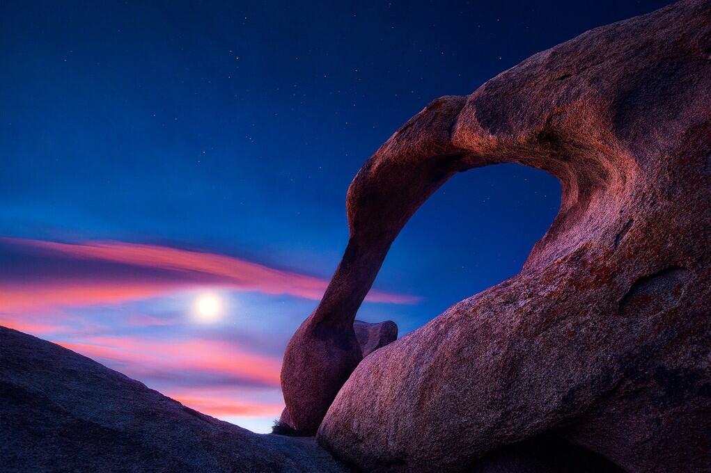


