Saguaro cactus and the Milky Way; photo by Bob Wick, U.S. Bureau of Land Management. Via Wilderness Society on Twitter, and flickr.
The Wilderness Society added a quote:
“I wish to know an entire heaven and an entire earth.” – Henry David Thoreau
If I had to guess, I’d say somewhere between Phoenix and Tucson, but I don’t know. Mr. Wick managed to get a good exposure without distorting the shapes of the stars. Somewhere far away from city lights.
Anyone have more details? Gotta track down the quote, too.
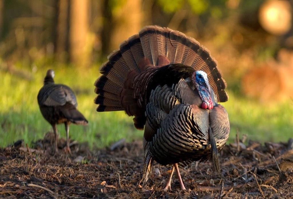
Turns out there are real turkeys in Alabama. They’ve expressed some concern that Judge Roy Moore impersonates a turkey in court.
A Thanksgiving salute from the denizens of our public lands.
From Interior Department’s Twitter feed: Here’s a handsome pair of wild turkeys to celebrate #Thanksgiving! Photo at Eufala NWR by Michael Padgett #Alabama
More:
Eufala National Wildlife Refuge: “The Eufaula National Wildlife Refuge was established in 1964 through community support and in cooperation with the U. S. Army Corps of Engineers. It is located on both banks of the Chattahoochee River in southeast Alabama and southwest Georgia. Named after the city of Eufaula, the refuge offers a variety of wetland and upland habitats for diverse fauna. A prominent feature of the abundant wetlands is Lake Eufaula (Walter F. George Reservoir) and several feeder streams”
Spread the word; friends don't allow friends to repeat history.
From our public lands, from the Twitter feed of the U.S. Department of Interior:
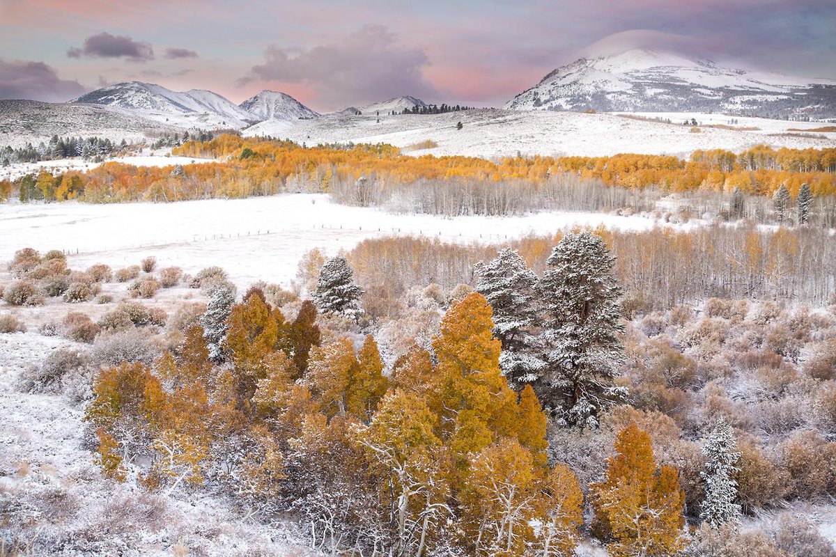
@Interior caption: Fall foliage and snow-capped peaks make for a stunning shot of Conway Summit #California @BLMca #nature
In my winter drives through the desert mountains of the Great Basin I often marveled at how a dusting of snow could turn a landscape generally painted in tones of brown with a little green into almost black and white. Then there are those black and white landscapes slashed by stunning gashes of color, or tinted subtley.
Conway Summit shows the stunning gashes of color this week. Grays, whites, blacks — and gold and pink. It’s in the western part of California, near Nevada and Mono Lake:
Conway Summit is named after John Andrew Conway, a settler in the area in 1880.[3][4] Geographically, it was formed from an upland plateau by the sinking of the land in the Mono basin area.[5] The Sawtooth Ridge of the eastern Sierra Nevada, topped by 12,279-foot (3,743 m) Matterhorn Peak, rise to the west of the pass; Green Creek and Virginia Lakes, in the Sierra Nevada to the west of the pass, are two local destinations for fishing, camping and aspen trees. The Bodie Hills and the infamous Bodie ghost town lie to the east.
This scene comes from our public lands, the undifferentiated lands held in trust by the Bureau of Land Management (BLM) and managed for multiple uses. You and I may look at this photo and marvel at the beauty of America, and say a little prayer of thanks for our public lands. Sens. Mike Lee and Ted Cruz see potential for high-dollar vacation residences throughout this scene, if only the land could be sold off.
Spread the word; friends don't allow friends to repeat history.
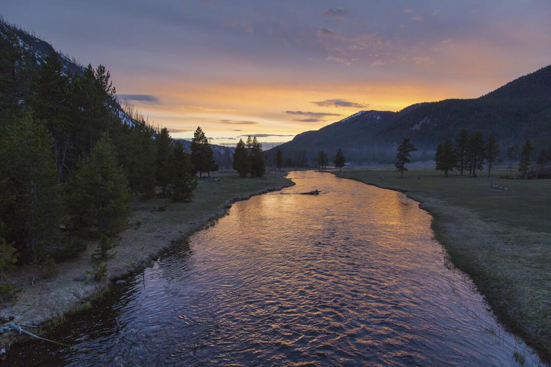
Photo after photo, I come increasingly to understand why my oldest brother, Jerry, wanted to spend his life and eternity in the Yellowstone.
Wholly apart from the thermal “features” and geological wonders, the area is just smashingly beautiful day in and day out, in even the mundane areas away from the celebrated features.
Here’s a part of the Madison River, just flowing through its streambed, at sunset.
Yellowstone National Park’s Twitter feed: Spring sunset on the Madison River. pic.twitter.com/8nZSxJvBeZ
Spread the word; friends don't allow friends to repeat history.
A family off to find and settle their homestead, 1886. Photo from the National Archives
History and demographics of the United States were forever changed when the Homestead Act became law early in the administration of President Abraham Lincoln, on May 20, 1862.
With Congress paralyzed and unable to act to do even minor good things now, it’s astonishing to think how the Congress of 1862 could do so much to open the American west, in the middle of the American Civil War. Perhaps Congress was able to act because legislators from the South were absent, and did not oppose progress.
In any case, the Homestead Act encouraged Americans who lacked property to strike out for the western territories and states, to make a new life, to found new towns, cities and farms, and fulfill what some call the nation’s “manifest destiny.”
The bill that became the Homestead Act, H.R. 125, in the 37th Congress, 1862. Image from the U.S. National Archives
The notion that the United States government should give free land titles to settlers to encourage westward expansion became popular in the 1850s. During that time the U.S. House of Representatives passed numerous homestead bills but southern opposition in the Senate prevented enactment. In 1860, during the 36th Congress, the Senate narrowly passed a homestead act but President James Buchanan vetoed it and the Senate failed its override attempt.
When the 37th Congress convened for its brief summer session in 1861, now without members from seceded states, it was preoccupied with Civil War-related legislation. The House took up briefly the homestead issue in December but postponed further consideration of it until the following February. The House finally passed the Homestead Act on February 28, 1862 by the large margin of 107 to 16. The act worked its way through the Senate until May 6, 1862 when it passed easily by a vote of 33 to 7. After a few minor changes in conference committee—which both houses agreed to without controversy—Congress sent the final legislation to President Abraham Lincoln who signed the act into law on May 20, 1862.
The Homestead Act encouraged western migration by providing settlers with 160 acres of land in exchange for a nominal filing fee. Among its provisions was a five-year requirement of continuous residence before receiving the title to the land and the settlers had to be, or in the process of becoming, U.S. citizens. Through 1986, when the last claim was made in Alaska, the Homestead Act distributed 270 million acres of land in the United States making it arguably one of the most far-reaching pieces of legislation in American history.
Photograph of Daniel Freeman on his homestead, circa 1904; in 1863 Freeman, then a Scout for the Union Army, became the first American to file an application for a homestead, in Nebraska; Library of Congress photo
For most of the history of homesteading, the Bureau of Land Management (BLM) was the principle agency that took the applications and administered the program; BLM’s on-line exhibition for the 150th anniversary of the Homestead Act in 2012 holds interactive media presentations, and more information
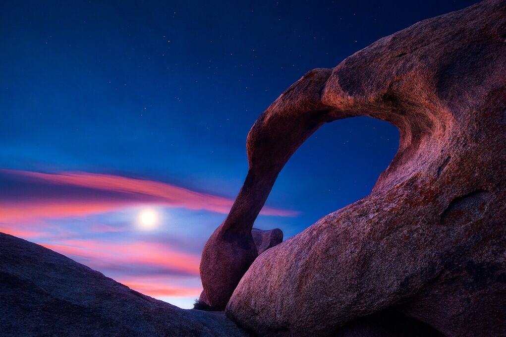
U.S. Department of Interior, Twitter feed: Beautiful view of the Moon over Mabius Mobius Arch in the Alabama Hills Recreation Area. #California @BLMca pic.twitter.com/u0KYyJ6p0S
Interesting points, reasons to like this image:
No, that’s not the Sun. It’s the Moon.
Who knew California had natural arches? I mean, it makes sense — but there’s one in Virginia, and a bunch of them at Arches National Park, and . . .
An arch that should be in Utah, in the Alabama Hills, but not in Alabama, in California.
America’s public lands, showing how they are unexcelled at astonishing us.
What? Interior called the “Mabius Arch?” No, it’s the Mobius Arch!
This place was named after the Confederate warship C.S.S. Alabama. Sympathetic miners making claims on minerals, it appears. “The unusual name Alabama Hills came about during the Civil War. In 1864 Southern sympathizers in Lone Pine discovered gold ‘in them thar hills.’ When they heard that a Confederate cruiser named the Alabama had burned, sunk or captured more than 60 Federal ships in less than two years they named their mining claims after the cruiser to celebrate. Before long the name applied to the whole area. Coincidentally, while Southerners were prospecting around Lone Pine, there were Union sympathizers 15 miles north near Independence. And when the Alabama was sunk off the coast of France by the U.S.S. Kearsarge in 1864, the Independence people struck back. They not only named their mining claims ‘Kearsarge’ but a mountain peak, a mountain pass, and a whole town as well.”
Geologists will love that this area is a prime example of chemical erosion — rocks made out of the same stuff as the craggy Sierra Nevada Mountains in the distance, but eroded differently.
Lichens by moonlight! (Or is that just desert varnish?)
More:
Alabama Hills Recreation Area: “On May 24, 1969, the BLM dedicated nearly 30,000 acres of public land west of Lone Pine, CA, as the Alabama Hills Recreation Area. Management plans are being considered that will eventually include a scenic trail system that people may walk and enjoy this geologic phenomena at a leisurely pace.“
Passenger jet and Moon. Photo by Rodger Schmitt, from Lake Powell, Utah.
Handheld Nikon. Nikon stabilizing lens. Good hands, I’d say.
Third to last time I was out near Lake Powell, I was with Rodger (and about a dozen others) organizing hearings of the President’s Commission on Americans Outdoors. We flew into Page, Arizona, on an Otter II coming up from Phoenix flying low, looking for elk, and legally buzzing Rainbow Bridge (impressive from the air, too).
We had a luncheon meeting at Wahweap Marina, as I recall; no time for boating.
Then we were off to the South Rim of the Grand Canyon. There we inspected pine trees 30 feet tall, growing between the ties of the then-abandoned rail lines. (And did a lot of other stuff.)
Today trains carry tourists to the South Rim on those tracks, the trees gone. Progress, really.
Rodger carries on in the knowledge that use of the outdoors, especially these public lands, heals souls, and sometimes gives you great photos.
Rodger said I could borrow the photo. Thanks!
Spread the word; friends don't allow friends to repeat history.
It’s a relic of the Civil War and Congress’s intention to strengthen the Union when Nevada became a state in 1864, but there it is, in Section 2 of the Nevada Constitution, making a mockery of Cliven Bundy’s claim to owe allegiance to Nevada and its Constitution, but not to the U.S.:
Sec: 2. Purpose of government; paramount allegiance to United States.All political power is inherent in the people[.] Government is instituted for the protection, security and benefit of the people; and they have the right to alter or reform the same whenever the public good may require it. But the Paramount Allegiance of every citizen is due to the Federal Government in the exercise of all its Constitutional powers as the same have been or may be defined by the Supreme Court of the United States; and no power exists in the people of this or any other State of the Federal Union to dissolve their connection therewith or perform any act tending to impair[,] subvert, or resist the Supreme Authority of the government of the United States. The Constitution of the United States confers full power on the Federal Government to maintain and Perpetuate its existance [existence], and whensoever any portion of the States, or people thereof attempt to secede from the Federal Union, or forcibly resist the Execution of its laws, the Federal Government may, by warrant of the Constitution, employ armed force in compelling obedience to its Authority.
Sheesh!
Here’s the essay quiz, students: The standoff between the Bureau of Land Management cowboys — each of whom swore an oath to uphold and defend the Constitution of the U.S., in contrast to Mr. Bundy who claims to owe no allegiance to the U.S. — and the armed mob who threatened to kill those same employees of our U.S. government: Did Nevadans (or Idahoans) violate any part of Section 2 of the Nevada Constitution? Which clauses?
I used to say “the Sagebrush Rebellion is over; sagebrush won.” Even the sagebrush are losing this one.
From The Atlantic: Eric Parker, who lives in central Idaho, aims his weapon from a bridge as protesters gather by the Bureau of Land Management’s base camp in Bunkerville, Nevada. (Jim Urquhart/Reuters) (See also Article III, Section 3 of the U.S. Constitution, with regard to Mr. Parker’s actions here.)
It’s an oversimplification, but not an oversimplification that leads to inaccuracy.
I say “oversimplification” because President Reagan did not impose grazing fees for the first time, but instead set rates at the time. U.S. grazing fees grew out of the 1934 Taylor Grazing Act, which included among other noble purposes the saving of unoccupied public lands from erosion, to prevent them from contributing to a national Dust Bowl. The Bureau of Land Management (BLM) manages about 245 million acres of land in the U.S., highly concentrated in 13 western states (about 86% of Nevada is public lands of one sort or another). Of those lands, about 155 million acres are open to grazing. BLM is part of the U.S. Department of Interior. Reagan’s Executive Order came when the law authorizing grazing fees had expired, and Congress was at an impasse in passing a new one, partly over a Reagan Administration proposal to raise grazing fees to market value, a multiple of fees then (and now) in effect.
Sagebrush Rebellion catches Tea Party Stupid disease, it seems to me. If the virus hasn’t been cured since 1993, what are the odds Mr. Bundy will sit still for a cure now?
Mad City Quanta, a Nebraska on-line comic, on grazing fees issues in 2012. To update it, substitute “Bundy” for “Fischer” on the tie of the steer on the left.
Spread the word; friends don't allow friends to repeat history.
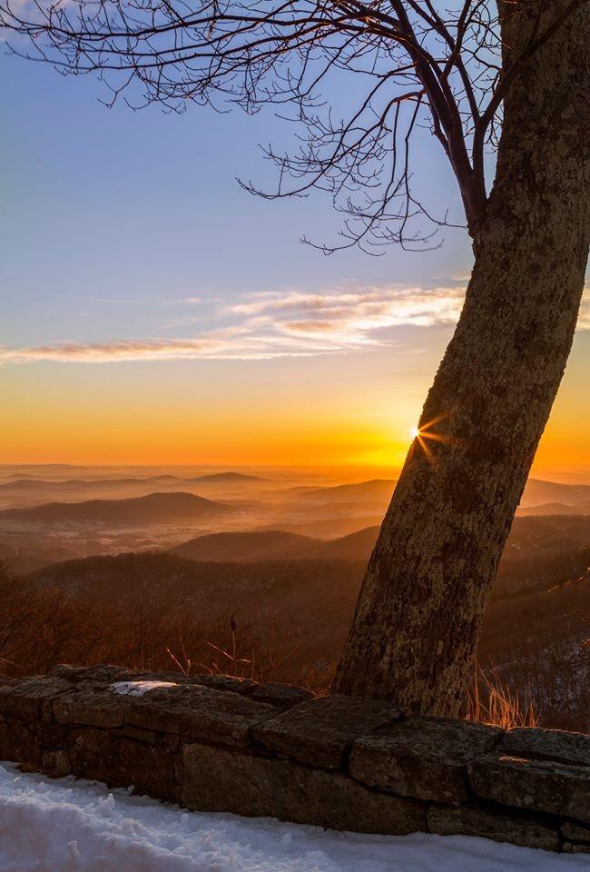
US Dept of Interior Tweet: Beautiful #sunrise over @ShenandoahNPS last weekend. #Virginia #travel #nature pic.twitter.com/T2sEgczGsz
Probably taken along the Blue Ridge Parkway. At the bottom of the photo, note the stone wall, probably built by the Civilian Conservation Corps during the Franklin Roosevelt administration, and still contributing to America’s beauty and economy 80 years later.
I can imagine driving along, catching a beautiful sunrise, but not being at a point to stop to photograph it. Driving farther along, the photographer found a safe place to stop, but the sunrise itself was gone by 15 minutes. With the aid of a young tree, however, the photographer can recapture that moment of the Sun’s peeking over the horizon, without special effects. Nice thought for the shot.
Spread the word; friends don't allow friends to repeat history.
World and U.S. history classes should be long past this point, but the photo just recently surfaced:
From America’s Outdoors: Bering Land Bridge National Preserve – Gone are the shockingly bright pinks, yellows and purples of summer, replaced by deeper and darker reds, yellows, greens and the beginnings of brown, all of equal vibrancy and beauty. And soon, as the 34 degree weather and diminishing daylight would lead us to believe, a blanket of white will fall upon the landscape. Enjoy the change of seasons wherever you may be!
Bering Land Bridge National Preserve? Did you even know there was such a thing? Part of our public lands, your tax dollars at work.
Not a place for a Sunday drive. There are no roads to get to the place. For students, this site offers a lot of photos and interesting stuff for projects in history (human migrations) and geography (land forms, lava flows, migration routes, wilderness).
Either someone just spent a very cold night to get a photo, or they’re getting ready to spend a very cold night.
Which is it?
US Dept of Interior: If you haven’t seen Steens Mountain in #Oregon, you really should check out this stunning photo from @BLMOregon pic.twitter.com/H2eePMmfsX
Steens Mountain is a large fault-block mountain in the southeastern part of the U.S. state of Oregon. Located in Harney County, it stretches some 50 miles (80 km) long north to south, and rises from alongside the Alvord Desert at elevation of about 4,200 feet (1,300 m) to a summit elevation of 9,733 feet (2,967 m). It is sometimes confused with a mountain range, but is properly a single mountain.
Or, until that account is unsuspended by the forces supporting Donald Trump: Follow @FillmoreWhite, the account of the Millard Fillmore White House Library
We've been soaking in the Bathtub for several months, long enough that some of the links we've used have gone to the Great Internet in the Sky.
If you find a dead link, please leave a comment to that post, and tell us what link has expired.
Thanks!
Retired teacher of law, economics, history, AP government, psychology and science. Former speechwriter, press guy and legislative aide in U.S. Senate. Former Department of Education. Former airline real estate, telecom towers, Big 6 (that old!) consultant. Lab and field research in air pollution control.
My blog, Millard Fillmore's Bathtub, is a continuing experiment to test how to use blogs to improve and speed up learning processes for students, perhaps by making some of the courses actually interesting. It is a blog for teachers, to see if we can use blogs. It is for people interested in social studies and social studies education, to see if we can learn to get it right. It's a blog for science fans, to promote good science and good science policy. It's a blog for people interested in good government and how to achieve it.
BS in Mass Communication, University of Utah
Graduate study in Rhetoric and Speech Communication, University of Arizona
JD from the National Law Center, George Washington University


 Posted by Ed Darrell