13-year-old paperboy Chester Kahapea happily hawks a commemorative edition of the Honolulu Star-Bulletin with the headline showing the state had achieved statehood after the U.S. House of Representatives passed the law authorizing Hawaii as a state. Star-Bulletin photo by Murray Befeler.
Specimen copy of the ballot used by Hawaiians in a June 27, 1959, plebiscite to approve conditions of statehood. Image from Hawaii Magazine, 2009
After the U.S. annexed Hawaii in 1898 (in action separate from the Spanish-American War) attempts at getting Hawaii admitted as a state got rolling. After World War II, with the strategic importance of the islands firmly implanted in Americans’ minds, the project picked up some steam. Still, it was 14 years after the end of the war that agreements were worked out between the people of Hawaii, the Hawaiian royal family, Congress and the executive branch. The deal passed into law had to be ratified by a plebiscite among Hawaiian citizens. The proposition won approval with 94% of votes in favor.
Other than the tiny handful of loudmouth birthers, most Americans today are happy to have Hawaii as a state, the fifth richest in the U.S. by personal income. The nation has a lot of good and great beaches, but the idea of catching sun and surf in Hawaii on vacation might be considered an idealized part of the American dream.
From Prologue, the blog of the National Archives: This petition, rolled onto a wooden spool, was signed by 116,000 supporters of Hawaii statehood and presented to the U.S. Senate on February 26, 1954. (RG 46, Records of the U.S. Senate)
U.S. postage stamp issued in 2009 commemorating the 50th anniversary of Hawaii’s admission to the union.
Contrast the first class postage price above with the airmail postage price of this stamp issued in 1959 — August 21, 1959 7¢ Rose Hawaii Statehood stamp. Wikipedia image
Rare color photograph of the first nuclear test at Trinity site, July 16, 1945. Blurriness is in the original photograph (done when color photography was still fairly new). (Photo credit: Wikipedia)
This is based on an earlier post, and is mostly an encore post.
Spread the word; friends don't allow friends to repeat history.
Department of Interior, May 18, 2014 — Here’s our most popular photo on social media last week celebrating @GlacierNPS 104th birthday. pic.twitter.com/JNaYYNnfcH
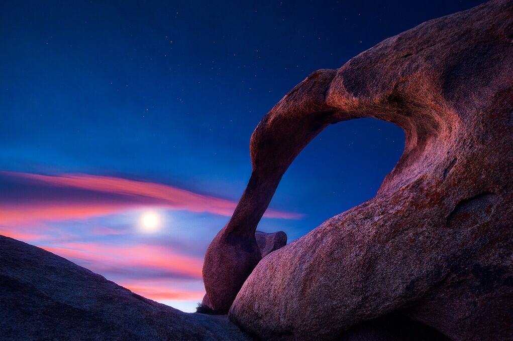
U.S. Department of Interior, Twitter feed: Beautiful view of the Moon over Mabius Mobius Arch in the Alabama Hills Recreation Area. #California @BLMca pic.twitter.com/u0KYyJ6p0S
Interesting points, reasons to like this image:
No, that’s not the Sun. It’s the Moon.
Who knew California had natural arches? I mean, it makes sense — but there’s one in Virginia, and a bunch of them at Arches National Park, and . . .
An arch that should be in Utah, in the Alabama Hills, but not in Alabama, in California.
America’s public lands, showing how they are unexcelled at astonishing us.
What? Interior called the “Mabius Arch?” No, it’s the Mobius Arch!
This place was named after the Confederate warship C.S.S. Alabama. Sympathetic miners making claims on minerals, it appears. “The unusual name Alabama Hills came about during the Civil War. In 1864 Southern sympathizers in Lone Pine discovered gold ‘in them thar hills.’ When they heard that a Confederate cruiser named the Alabama had burned, sunk or captured more than 60 Federal ships in less than two years they named their mining claims after the cruiser to celebrate. Before long the name applied to the whole area. Coincidentally, while Southerners were prospecting around Lone Pine, there were Union sympathizers 15 miles north near Independence. And when the Alabama was sunk off the coast of France by the U.S.S. Kearsarge in 1864, the Independence people struck back. They not only named their mining claims ‘Kearsarge’ but a mountain peak, a mountain pass, and a whole town as well.”
Geologists will love that this area is a prime example of chemical erosion — rocks made out of the same stuff as the craggy Sierra Nevada Mountains in the distance, but eroded differently.
Lichens by moonlight! (Or is that just desert varnish?)
More:
Alabama Hills Recreation Area: “On May 24, 1969, the BLM dedicated nearly 30,000 acres of public land west of Lone Pine, CA, as the Alabama Hills Recreation Area. Management plans are being considered that will eventually include a scenic trail system that people may walk and enjoy this geologic phenomena at a leisurely pace.“
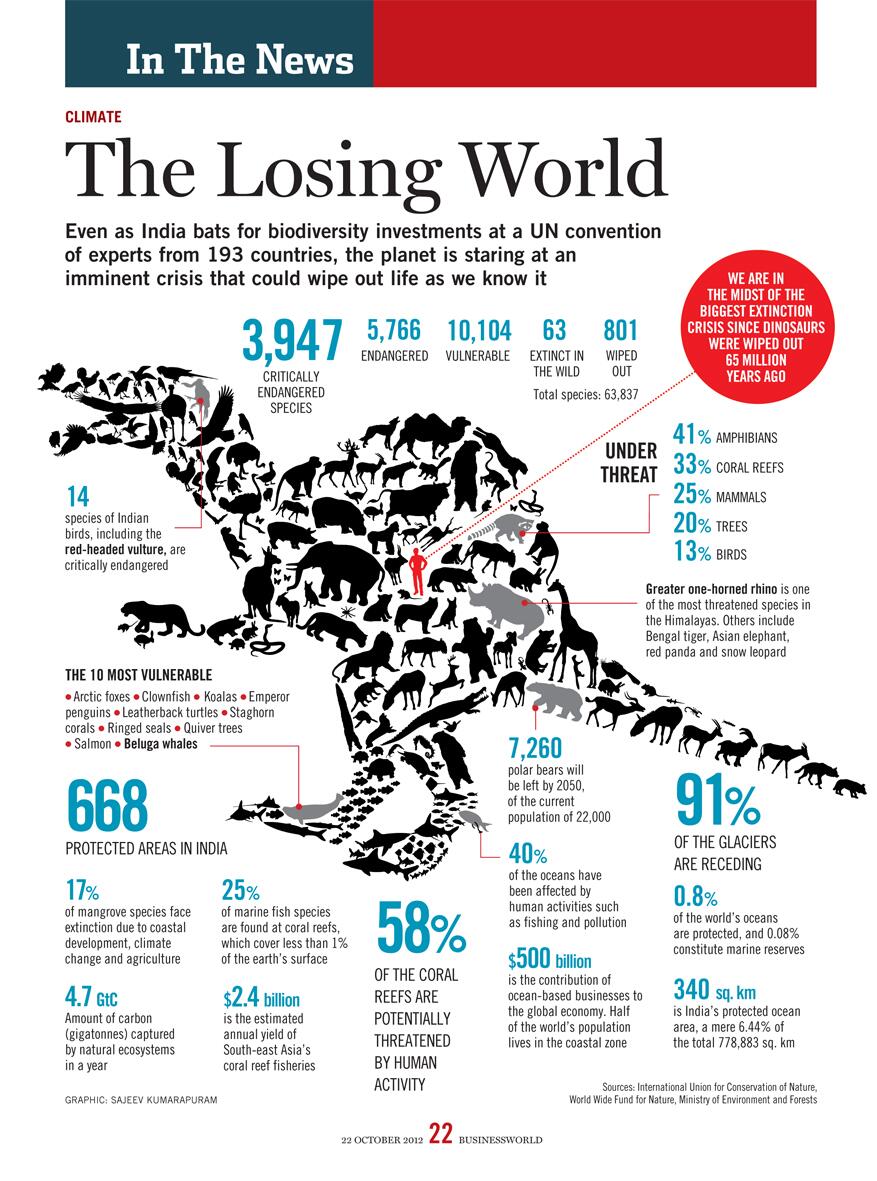
Even as India bats for biodiversity investments at a UN convention of experts from 193 countries, the planet is staring at an imminent crisis that could wipe out life as we know it.
This would be a good poster for geography, biology, general science and world history courses. Can your drafting class print this out for you in poster format?
When all of the “coal mine canaries” on Earth die out, how much longer have humans left to live on Earth?
ven as India bats for biodiversity investments at a UN convention of experts from 193 countries, the planet is staring at an imminent crisis that could wipe out life as we know it.Compiled by Yashodhara Dasgupta
ven as India bats for biodiversity investments at a UN convention of experts from 193 countries, the planet is staring at an imminent crisis that could wipe out life as we know it.Compiled by Yashodhara Dasgupta
Poster from BioMed Central for World Malaria Day 2014
Time for a big push to smash the disease’s hold on humanity, maybe eradicate it. Are you in?
No, DDT is not the answer, not even much of AN answer.
How can you help, right now?
Send $10 to Nothing But Nets. Bednets are dramatically more effective than just insecticides, in preventing malaria infections and saving lives. Your $10 donation will save at least one life.
Write to your Congressional delegation, and urge them to increase funding to the President’s Malaria Initiative. Malaria does well when people in non-malaria regions turn their backs on the problem. Malaria declines with constant attention to nation-wide and continent-wide programs to prevent the disease, by diminishing habitat for mosquitoes, curing the disease in humans so mosquitoes have no well of disease to draw from, and preventing mosquitoes from biting humans, with window screens, education on when to stay indoors, and bednets.
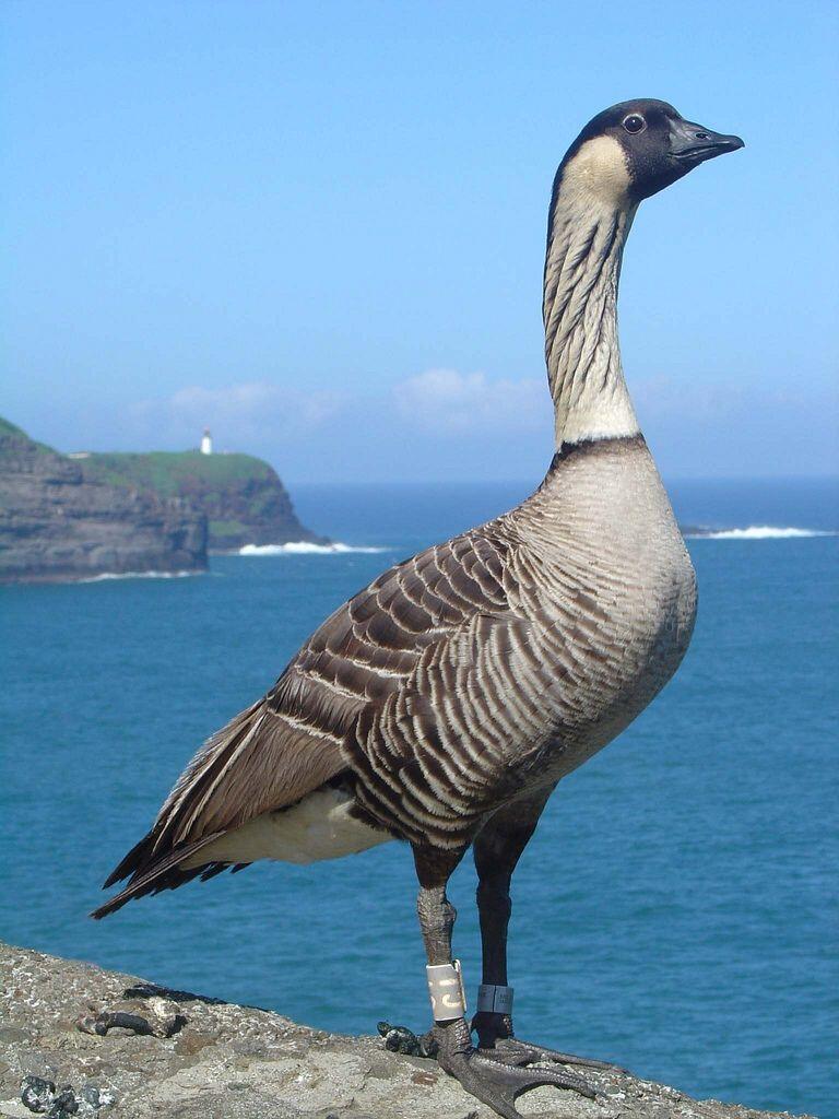
Caption: USFWS Refuge System @USFWSRefuges – Nene hatchings on James Campbell National Wildlife Refuge are first in [Oahu] Hawaii in centuries http://bit.ly/1jBxFrT pic.twitter.com/PK2l9PVa3v (this photo taken on Kaui, at the Kilauea Point National Wildlife Refuge). Photograph by Brenda Zaun/USFWS/Flickr Creative Commons
Bones found on Oahu show they once thrived there. A few birds — blown off course again, or looking for more territory? — moved to Oahu a few months ago, and have raised young. Scientists are watching to see how it works out.
With short name featuring only two different letters, “Nene” is a popular crossword answer, and clue. Some ornithologists half-joke that the familiarity among crossword enthusiasts was a huge aid in getting aid for the wild populations of the bird, and in getting the Endangered Species Act passed into law.
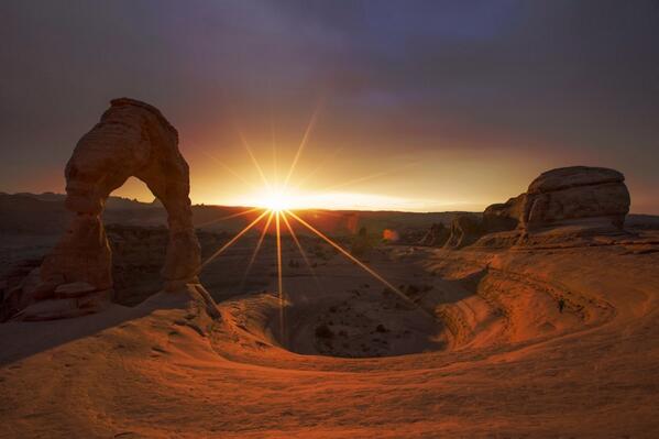
From the U.S. Department of Interior: This stunning photo of dusk @ArchesNPS by Jonathan Backin is the perfect way to end the week. #utah #nature pic.twitter.com/5bIanEG8sZ
Delicate Arch, with a dusting of snow, as the sun sets.
A great reason to live in Moab, Utah, or visit there.
Spread the word; friends don't allow friends to repeat history.
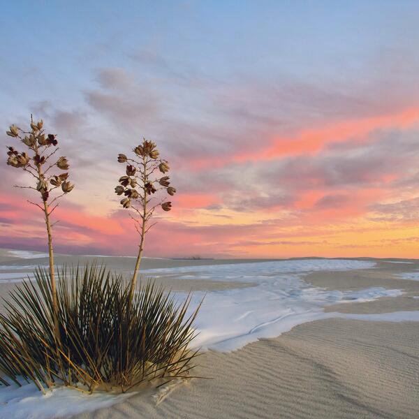
Department of Interior Great American Outdoors Tumblr caption: One of the world’a great natural wonders – the glistening white sands @WhiteSands_NPS. #NewMexico pic.twitter.com/dbzPpIfSRW
One of the problems of touring places like White Sands National Monument is that most tourists arrive mid-day; most spectacular views are probably close to sunrise or sunset, when the sky adds colors other than “bright” to the scene.
Rising from the heart of the Tularosa Basin is one of the world’s great natural wonders – the glistening white sands of New Mexico. Great wave-like dunes of gypsum sand have engulfed 275 square miles of desert, creating the world’s largest gypsum dunefield. White Sands National Monument preserves a major portion of this unique dunefield, along with the plants and animals that live here.
Yes, the same White Sands where the Trinity Project first triggered an atomic weapon, in 1945 — but the blast site is actually about 100 miles north of the National Monument on the military’s White Sands Missile Range. Historical reasons to visit, as well as nature and beauty reasons.
I assume that’s some sort of yucca in the photo; can you tell more specifically?
Department of Interior caption: Everglades National Park — This Alligator decided he wanted to stand out from all the others along the Anhinga Trail! (SD)
Spread the word; friends don't allow friends to repeat history.
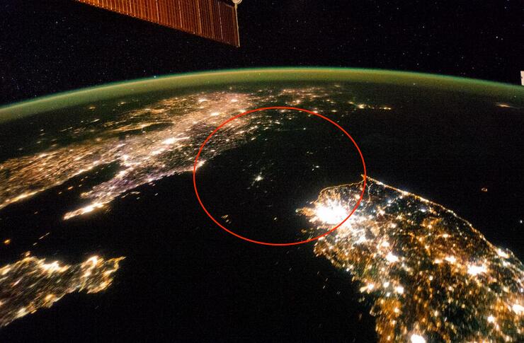
Here’s a photograph of one of the greatest, and longest-running tragedies of our time.
No, that’s not a stretch of water in the red circle. That’s North Korea, at night, blacked out by a lack of electrical lights.
Tweetpic from the Washington Post: North Korea looks like a sea of misery in this photo from space http://wapo.st/1c1B84q via @KnowMoreWP pic.twitter.com/nB3g8fa63Q
It’s a photo from the International Space Station taken in January.
The KnowMore blog from the Post describes the tragedy, and points to even more disturbing stories:
North Korea appears as nothing more than a shadow in the above photograph, taken at night aboard the International Space Station last month. South Korea’s eastern coastline is indistinguishable from the demilitarized zone along the border with the North, as though the Sea of Japan flowed into the Yellow Sea and Pyongyang were an island in a strait separating South Korea from China.
North Korea’s interior is nearly invisible from orbit at night, just as what happens inside the country on a day-to-day basis is largely invisible to the outside world. U.N. investigators managed to shine a little light into North Korea’s darkest corners last month. [Click here to get to the U.N. report]
I’ve used similar photos in class. It’s a powerful exercise. North Korea is as dark as undeveloped and largely unpopulated areas of the Congo River Basin, the Australian Outback, the Arabian Peninsula’s “Empty Quarter,” and almost as dark as Antarctica.
No doubt stargazing is good in some of those dark spots in North Korea. This is one case where the absence of light pollution does NOT indicate good planning, but instead an amazing paucity of rational development.
Spread the word; friends don't allow friends to repeat history.
Lightning strikes in Monument Valley, on the Navajo Reservation, Utah. Photography by Carolyn Slay (Oak Ridge, TN); Monument Valley, UT Feb. 20 2014 Via smithsonianmag.com.
Reader and veteran librarian Judy Crook sent a Tweet alerting us to a recent release from the U.S. National Archives, “A Welcome to Britain, 1943.”
It’s a fascinating little film, if 38 minutes is still “little.”
Yes, that’s Burgess Meredith playing the soldier. I haven’t confirmed whether he was actually enlisted, but he often played soldiers or people at war — in 1945, playing war reporter Ernie Pyle, for example. In the 1950s, the House Committee on Unamerican Activities (HUAC) claimed Meredith had consorted too closely with communists, and he was blacklisted for years including a seven-year drought of work.
When this film was made, the Soviet Union was an ally of Britain and the United States. How times change.
This is a training film made by the War Department (later renamed “Defense Department”), to acquaint U.S. soldiers with what they would confront in Britain. Why did soldiers need such training? You can guess, perhaps. 258
Teachers, can you use this film in history class? Is the discussion on civil rights, about 20 minutes at 25:30 in, instructive in the history of the time?
From the National Archives’s description on YouTube:
Published on Feb 5, 2014
Creator(s): Department of Defense.~. Armed Forces Radio and Television Service. (1954 – ) (Most Recent)
Series : Information and Education Films, compiled 1943 – 1969
Record Group 330: Records of the Office of the Secretary of Defense, 1921 – 2008
Access Restriction(s): Unrestricted
Use Restriction(s): Restricted – Possibly
Note: Some or all of this material may be restricted by copyright or other intellectual property restrictions.
Scope & Content: This film introduced soldiers to Britain and told them what to expect, how to behave and how not to behave in Britain during World War II. It includes footage of military cameramen and black soldiers.
Contact(s): National Archives at College Park – Motion Pictures (RD-DC-M), National Archives at College Park, 8601 Adelphi Road, College Park, MD 20740-6001
Phone: [omitted here]
National Archives Identifier: 7460305
Local Identifier: 330-IEF-7
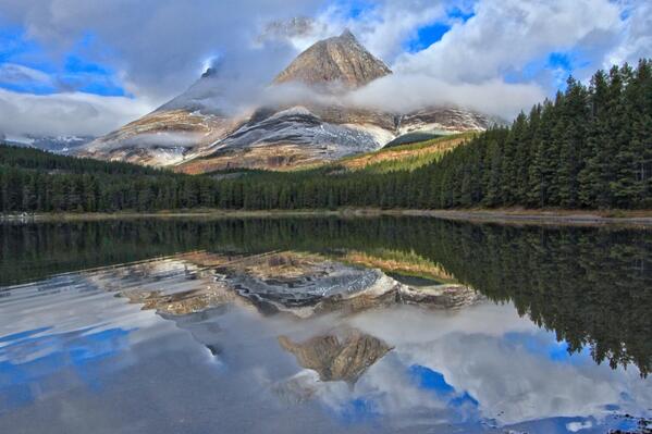
From the U.S. Department of Interior: Really cool reflection photo from America’s largest national park: @WrangellStENPS in #Alaska. pic.twitter.com/WHUYkgJNTH
Wrangell-St. Elias is our largest National Park? At 20,587 square miles, it’s about 80% as large as West Virginia, and larger than nine other states.
Wrangell-St. Elias National Monument was initially designated on December 1, 1978 by President Jimmy Carter using the Antiquities Act, pending final legislation to resolve the allotment of public lands in Alaska. Establishment as a national park and preserve followed the passage of the Alaska National Interest Lands Conservation Act in 1980. The park, which is bigger than the nation of Switzerland, has long, extremely cold winters and a short summer season. It supports a variety of large mammals in an environment defined by relative land elevation. Plate tectonics are responsible for the uplift of the mountain ranges that cross the park. The park’s extreme high point is Mount St. Elias at 18,008 feet (5,489 m), the second tallest mountain in both the United States and Canada. The park has been shaped by the competing forces of volcanism and glaciation. Mount Wrangell is an active volcano, one of several volcanoes in the western Wrangell Mountains. In the St. Elias Range Mount Churchill has erupted explosively within the past 2000 years. The park’s glacial features include Malaspina Glacier, the largest piedmont glacier in North America, Hubbard Glacier, the longest tidewater glacier in Alaska, and Nabesna Glacier, the world’s longest valley glacier. The Bagley Icefield covers much of the park’s interior, which includes 60% of the permanently ice-covered terrain in Alaska. At the center of the park, the boomtown of Kennecott exploited one of the world’s richest deposits of copper from 1903 to 1938, exposed by and in part incorporated into Kennicott Glacier. The mine buildings and mills, now abandoned, compose a National Historic Landmark district.
But just try to get a commitment as to its origins. Photographic, or artist’s image?
I wagered the latter. Note general lack of thick clouds, angle of sunlight, etc.
Beautiful Antarctica from space. Photographic image, or artist’s rendering? Who deserves credit for the image?
Then, at Twisted Sifter (shout out to Annette Breedlove; and everyone outside my family will be mystified by that reference) I found this, the full image from NASA. Notice how some selective editing, changing the perspective, makes the image above more fascinating — while stripping out the identifying credits:
Image via Twisted Sifter; NASA image of Antarctica, available at Flickr Commons
Seen above is a view of the Earth on September 21, 2005 with the full Antarctic region visible. The composite image shows the sea ice on September 21, 2005, the date at which the sea ice was at its minimum extent in the northern hemisphere. The colour of the sea ice is derived from the AMSR-E 89 GHz brightness temperature while the extent of the sea ice was determined by the AMSR-E sea ice concentration. Over the continents, the terrain shows the average land cover for September, 2004. The global cloud cover shown was obtained from the original Blue Marble cloud data distributed in 2002. [Source]
Due to the position of Antarctica in relation to our Sun it would not look like this to the naked eye. This is a composite that shows what Antarctica looks like if the entire continent were illuminated.
Click here for the full resolution 8400×8400 pixel TIFF version (63 mb) and click here for the 8400 x 8400 px JPG version.
Global View of the Arctic and Antarctic on September 21, 2005
Collection: NASA Scientific Visualization Studio Collection
Title: Global View of the Arctic and Antarctic on September 21, 2005
Instrument: Terra/MODIS
Instrument: Aqua/AMSR-E
Description: This image shows a view of the Earth on September 21, 2005 with the full Antarctic region visible.
Abstract: In support of International Polar Year, this matching pair of images showing a global view of the Arctic and Antarctic were generated in poster-size resolution. Both images show the sea ice on September 21, 2005, the date at which the sea ice was at its minimum extent in the northern hemisphere. The color of the sea ice is derived from the AMSR-E 89 GHz brightness temperature while the extent of the sea ice was determined by the AMSR-E sea ice concentration. Over the continents, the terrain shows the average landcover for September, 2004. (See Blue Marble Next Generation) The global cloud cover shown was obtained from the original Blue Marble cloud data distributed in 2002. (See Blue Marble:Clouds) A matching star background is provided for each view. All images include transparency, allowing them to be composited on a background.
Completed: 2007-02-08
Credit: *Please give credit for this visualization to* NASA/Goddard Space Flight Center Scientific Visualization Studio The Blue Marble data is courtesy of Reto Stockli (NASA/GSFC).
Studio: SVS
Animator: Cindy Starr (Lead)
Scientist: Ronald Weaver (University of Colorado)
Data Collected: AMSR-E Sea Ice: 2005-09-21; Blue Marble cloud layer 2002; Blue Marble Next Generation Seasonal Landcover 2004-09
Visit www.nasaimages.org for the most comprehensive compilation of NASA stills, film and video, created in partnership with Internet Archive.
The image, and it’s odyssey and story, are reminders that reality is often better than the made up stuff; and it’s wise to properly attribute stuff you borrow. Is this just a cool image, or an opportunity for teachers to enrich the classroom and an argument for boosting NASA’s budget?
Or, until that account is unsuspended by the forces supporting Donald Trump: Follow @FillmoreWhite, the account of the Millard Fillmore White House Library
We've been soaking in the Bathtub for several months, long enough that some of the links we've used have gone to the Great Internet in the Sky.
If you find a dead link, please leave a comment to that post, and tell us what link has expired.
Thanks!
Retired teacher of law, economics, history, AP government, psychology and science. Former speechwriter, press guy and legislative aide in U.S. Senate. Former Department of Education. Former airline real estate, telecom towers, Big 6 (that old!) consultant. Lab and field research in air pollution control.
My blog, Millard Fillmore's Bathtub, is a continuing experiment to test how to use blogs to improve and speed up learning processes for students, perhaps by making some of the courses actually interesting. It is a blog for teachers, to see if we can use blogs. It is for people interested in social studies and social studies education, to see if we can learn to get it right. It's a blog for science fans, to promote good science and good science policy. It's a blog for people interested in good government and how to achieve it.
BS in Mass Communication, University of Utah
Graduate study in Rhetoric and Speech Communication, University of Arizona
JD from the National Law Center, George Washington University


 Posted by Ed Darrell


