Yo! History and geography teachers: Free state maps!

August 23, 2008

In the summer of my 8th year, after my uncle, Roland Christian*, sent me his collection of “official” state maps from his latest cross-country drive, several of us kids tried to collect maps of all 50 states. Considering we were in Burley, Idaho, it’s amazing that we could accumulate 36 different states, just by our badgering local gasoline stations for the free ones. We got on our bicycles and visited the stations, one after the other.

Free educational materials: A memory from a distant past.

I haven’t seen a free map from a gas station in years, maybe two decades. My love of geography, my love of chasing odd city names, strange routes, great sights, and history, was spurred by that map collection, I’m sure.

Today, though oil companies have gotten out of the tourism and driving promotion business, state tourism offices, or state road departments typically issue free maps. How to find them all?

To the rescue comes Less Than a Shoestring, with a list of the places to ask in each state, to get a free road map of the state. These maps are great helps for students doing a “project” on a different state. For the history class on your own state, if your school offers such a course, I think such maps are indispensable.

We teach Texas state history and geography in 7th grade. When I taught that course, one of the best classroom aids I had was a collection of the official map of Texas — a year old, but I got a couple dozen copies from the state’s tourism promotion group. They were anxious to get rid of the old maps, and I was very happy to have them.

Here’s something curious: The site, Less Than a Shoestring,  doesn’t list a place to get a map from the District of Columbia — Washington, D.C. You’d think that a town that depends so much on tourism would have an office to promote tourism that would pass out maps to make tourists’ trips easier. Is this just an indication of the great dysfunction of the D.C. government, or did we miss finding the site? Let me know in comments.

Tip of the old scrub brush to the Business Blog @ Capital Active.

____________________________

* Uncle Roland was a minister for the 7th-Day Adventists, and he traveled to preach around the country. Stuck in a small Idaho town for my first nine years, I thought Roland was a great world traveler. He always stopped to spend a night when he was within a state or two — he was a minister trying to travel on a shoestring, after all — and with his wonderful, deep, preacher’s voice, he had wonderful stories to tell. I miss him still, more than two decades after his death. Which of your nieces and nephews can you influence as Roland did?

Read the rest of this entry »


Spectacular waterfall discovered in Peru – adventurers off to document it

August 16, 2008

Gocta was unknown until a few years ago — to the outside world. Local Peruvians knew about it, but said little. Gocta turned out to be the third highest waterfall in the world

Lightning has struck Peru again: A week ago an expedition left paved-road civilization to document another very high waterfall, perhaps higher than Gocta, whose existence was only recently discovered, outside of local residents — who said nothing because they feared the reaction of the outside world, or they just didn’t think that anyone else would be particularly interested. The expedition includes “representatives of the sub-regional direction of Bagua Grande and Utcubamba, from Utcubamba’s National Institute of Culture, a topographer of the provincial municipality and a cameraman.”

Perus Gocta, the third-highest waterfall in the world - Alberto Pintado photo

Peru's Gocta, the third-highest waterfall in the world - Alberto Pintado photo

A local explorer, Obed Cabanillas Silva, who seems to be coordinating local efforts to make the cataract known, said there are “stone structures” on the path to the waterfall. Could there be undiscovered, uncharted ruins of former How does the rest of the world miss a waterfall higher than a 250-story building? Here’s a Google Earth challenge — how many other giant waterfalls are there in Peru, “undiscovered” by the rest of the world? Remember the recent discovery of an impact crater in Australia?

The expedition of “discovery” set off a week ago — can you beat them to the thing, on Google Earth, or with any other LandSat image? (The few pieces of data on the specific location I have are at the bottom of this post.)

Gocta itself came to light in 2005 when a German engineer working on a water project close by, persuaded the Peruvian government to survey the uncharted, unnamed waterfall. When the surveyors came back with a report the thing was 2,532 feet hight, the German, Stefan Ziemandorff, checked his National Geographic Guide, figured it was third largest in the world, and had the good sense to call a press conference to let everyone else know. (Ziemandorff first heard of the cataract in 2002.)

World Waterfall Database is more picky. They rank Gocta at #16 right now — something about free fall, flow amounts, other measures.

The discovery of Gocta produced documentation of other spectacular water features nearby, Catarata Yumbilla (870 m) and Cataratas la Chinata (580 m). One might wonder about what methodical search of the area might find.

Read the rest of this entry »


Government and civics class manipulables

August 13, 2008

Be sure to check out the customer comments, too.

I was looking for lesson plan ideas for government class. With my background in airline and airport management, this one just jumped out at me.

If only it were just fantasy for kids.

If only it were just fantasy for kids.

It may be useful for customer service classes and corporate training, too.

Big, wet and bubbly tip of the old scrub brush to This One Goes to Eleven.


In the Utah desert, a GPS is no substitute for common sense

August 10, 2008

A cardinal rule of driving the western U.S. is this: Don’t head off through the mountains or desert without knowing how you’re going to get back, or get to the next smattering of civilization.

Why? Old friend Peter B. Pope once trekked a chunk of Wyoming with another friend, and they had a bit of an altitude sickness scare. After three days above 9,000 feet, they realized they needed to get down, and that was a problem — miles of hiking. Help?

They picked that area of Wyoming to hike because the USGS topographical map showed no roads at all in that section. Real adventure territory. The only way to get help was to get out, and what they needed, really, was just to get out.

Or, consider the sign that used to greet travelers leaving Green River, Utah, going west on U.S. Highway 50: “No services for next 140 miles.” I once stopped to help a guy who had run out of gas 42 miles into that stretch. He confessed he’d seen the sign, but thought a bit less than a quarter-tank of gas in his old gas guzzler would do it. It hadn’t occurred to him it also meant no food or water, or towns, or telephones (I wonder if that road has cell coverage now). He was thinking of walking back for gas. 42 miles. It was well over 100°. I’m sure the highway patrol could have found him before he died.

Maps help. A compass is good. Having the skills of a First Class Boy Scout to use the map and compass together also benefits travelers.

If you have a compass, you still need a map; if you have a GPS, you still need to know whether the roads are passable. In short, you need to know where you’re going, how to get there, and whether you have the equipment to make the trip.

Comes this story from the Associated Press, in USA Today, about a “convoy” of people who thought they’d use a GPS to navigate the back country from Bryce Canyon National Park to the Grand Canyon. The only appropriate response is the one Will Smith’s character gave the woman whose husband had been killed so his skin could be used as a disguise by a giant interstellar cockroach in “Men In Black.” He said: “I mean . . . damn!”

Old friend, John Hollenhorst’s story of the incident on KSL-TV (Channel 5) carries pictures and maps that show just how foolish is the assumption that “a GPS and a cell phone are all they need to get by.”

Vodpod videos no longer available.

more about “ksl.com – Deputies rescue tourists lo…“, posted with vodpod

(KSL ought to let Hollenhorst play the expert on this story — he’s an Eagle Scout and once was an accomplished outdoorsman himself, perhaps still is.)

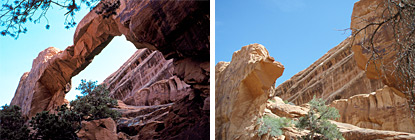
The group took off heading south from Grosvenor Arch, a natural arch south of the National Geographic-named Kodachrome Basin State Park. To get to Kodachrome Basin, you travel ten miles on unpaved roads. Going south out of Kodachrome Basin to Grosvenor Arch, you find the roads get less well-maintained. The maps show nothing but dirt roads, though some maps show a rather major dirt road that connects with Highway U.S. 89 east of Kanab, Utah, on the way to Page, Arizona. Most highway maps probably don’t convey the reality of the situation. This is the landscape you find:

White Cliffs in the Grand Staircase/Escalante National Monument (BLM photo)

White Cliffs in the Grand Staircase/Escalante National Monument (BLM photo)

It’s not exactly friendly to non-four-wheel-drive vehicles. It’s not friendly to any vehicle.

You don’t see a lot of roads in the 50 or 70 miles you can see, either. Roads that go through that area are unpaved, often unauthorized, and shouldn’t be on any map. Hollenhorst painted the scene:

The Californians ventured into one of the roughest and most remote landscapes in the United States. They believed their GPS unit would lead them back to a paved highway. They wound up desperately calling relatives in California in the middle of the night.

Yes, Virginia — and New York, and California — there really are places like that in America.

One relative, Esther Lahiji, said, “They ran out of gas and they lost their way. It was dark at night. And thank God they could charge their cell phones in their cars.”

The convoy of four vehicles, containing 13 adults and 10 children, had visited Bryce Canyon and Kodachrome Basin. But it left pavement to visit Grosvenor Arch. Using a GPS unit, they tried to reconnect to a paved road far to the south. But they got lost in a network of dirt roads, which Kane County Sheriff Lamont Smith says often lead nowhere.

“Those little spurs, those little dirt sandy spurs go out to the cliffs and dead-end,” he said.

With one vehicle stuck in sand and others running out of gas, they couldn’t go back. And heat was an issue, especially for the children.

The group stumbled into an area with cell phone coverage skipping from a distant tower — an area of accidental coverage (weather can change such coverage patterns — they are hit and miss, at best). They were able to phone for help.

After they called for help by cell phone, rescuers delivered food, water and gasoline and escorted them out.

Sheriff Smith says tourists just shouldn’t rely on a GPS unit in such rugged country.

“If you go off the pavement, you either need to ask the locals where the road goes or which roads to take, or else just stay on the paved roads, because a lot of these roads just don’t go anywhere,” he said.

Need we say it? Out there, one may not find locals to talk to. Last time Kathryn and I visited Kodachrome Basin, there were no other parties camping there — in August, at the height of the tourist season. South of the park? Are you serious? (We didn’t visit Kodachrome this summer.)

From Grosvenor Arch, to get to the Grand Canyon, go north back to Utah State Road 12; it’s about 20 miles. Then go east, through Tropic, Utah, and past the entrance to Bryce Canyon National Park to U.S. Highway 89 (about 30 miles). Highway 89 south to Kanab is another of the most spectacular drives in America, through miles and miles of millions of years of petrified sand dunes — white, red, ochre, maroon, purple and chocolate cliffs, juniper-pinyon desert, pink sands, green cottonwoods, and nice paved roads.

You can stop for coffee in Kanab, in the afternoon at a book/outdoors outfitter/coffee shop, Willow Canyon Outdoor (we stopped three different days — it’s a great cup of good coffee in an area more than 200 miles from the nearest Starbucks; which Starbucks may have the New York Times, Willow Canyon will have the latest High Country News to read; we picked up a couple of CDs of Beethoven for the drive, and had I had more sense, I could have gotten some good trekking poles there).

From Willow Canyon Outdoor, it’s about 40 miles to where that dirt road from Bryce Canyon enters U.S 89, if you survive the drive. It’ll take you two to three hours to make the drive and get coffeed up on paved road if you take the long way — this group from California spent several times that amount of time, and risked their lives.

Paved roads, great scenery, good coffee, nice drive, or you can eat dust and threaten your life. You choose.

Resources:


Disaster at Arches National Park

August 10, 2008

Wall Arch, 12th largest, one of the better-known and most-seen natural arches in Arches National Park, Utah, collapsed.

Wall Arch, before and after collapse - National Park Service photos

Wall Arch, before and after collapse – National Park Service photos

“Not being a geologist, I can’t get very technical but it just went kaboom,” [Arches NP] Chief Ranger Denny Ziemann said. “The middle of the arch just collapsed under its own weight. It just happens.”

Wall Arch, located along the popular Devils Garden Trail, was 71 feet tallwide and 33 1/2 feet widetall, ranking it 12th in size among the known arches inside the park. Lewis T. McKinney first reported and named Wall Arch in 1948.

No one reported observing the arch collapse and there were no visitor injuries, the National Park Service said.

Read the report from the Salt Lake Tribune.

Some tourist on Sunday, August 3, or Monday, August 4, got the last photograph of Wall Arch still standing. Was it you? Were you close? Give us a shout in the comments if so.

Other resources:

x

Other blogs and later reports:


63rd anniversary: Hiroshima, August 6; Nagasaki, August 9

August 9, 2008

63 years ago, U.S. military action brought a quick close to hostilities without an invasion of Japan, with the detonation of two atomic bombs, one over Hiroshima on August 6, 1945, and one over Nagasaki on August 9.

Daily Yomiuri Online carried a description of memorial events in Hiroshima today, from Yomiuri Shimbun:

NAGASAKI–The Nagasaki municipal government held a ceremony Saturday marking the 63rd anniversary of the atomic bombing of the city, at which participants called for the abolition of all nuclear weapons.

A total of 5,650 A-bomb survivors, representatives of victims’ families from around the nation and Nagasaki citizens participated in the ceremony. Prime Minister Yasuo Fukuda also attended the ceremony, which was held in Nagasaki Peace Park near ground zero.

Nagasaki Mayor Tomihisa Taue read out the Nagasaki Peace Declaration, which urges the worldwide abolition of nuclear weapons.

“Human beings have no future unless nuclear weapons are eliminated. We shall clearly say no to nuclear weapons,” Taue said.

The ceremony started at 10:40 a.m. Three books listing the names of 3,058 people confirmed to have died as a result of the bombing in the past year were placed inside a memorial box in front of the Peace Statue.

The total number of books listing the names of the deceased is 147, and the number of names is 145,984.

Representatives of surviving victims, bereaved families, the prime minister and Hiroshima Mayor Tadatoshi Akiba placed flowers at the site.

At 11:02 a.m., the time the atomic bomb struck, ceremony participants offered a silent prayer. At the same time, local high school students rang the Bells of Nagasaki.

In the peace declaration, Taue read from an academic paper written by four people, including a former U.S. secretary of state, which promoted a new policy for developing nuclear weapons. The proposal encouraged countries to ratify the Comprehensive Test Ban Treaty. The mayor said world nuclear powers “should sincerely fulfill their responsibility of nuclear disarmament,” and urged the government to pass the three nonnuclear principles into law.

This year also marks the 100th anniversary of the birth of Takashi Nagai, a medical doctor who helped rescue of victims after the bombing.

The mayor referenced one of the doctor’s remarks, saying: “There are no winners or losers in a war. There is only destruction.”

Shigeko Mori, 72, representing survivors of the bombing, read out an oath for peace that said Japan should promote its Constitution and the three nonnuclear principles to the rest of the world to prevent nuclear proliferation.

Fukuda gave a speech, saying, “Japan should play a responsible role in the international community as a nation cooperating for peace.”

(Aug. 10, 2008)

Other information:

Other related posts at Millard Fillmore’s Bathtub:


Alpine Loop? Try Utah’s, gentler, prettier than Colorado’s

August 6, 2008

Utah’s canyons have so many pretty spots. Taking visitors through them I always heard about how no one expected such beauty in the desert. So I was excited to see the headline in Sunday’s Dallas Morning News about taking the Alpine Loop.

Autumn aspens in Utahs Alpine Loop - Wikimedia photo

Autumn aspens in Utah's Alpine Loop - Wikimedia photo

Prettiest drive you can make in a day. Start out in American Fork, head up American Fork Canyon, cross over to the backside of Mt. Timpanogos — you’ll see aspen, pines, fir, some of the prettiest streams you’ve ever seen anywhere. Some years back the Utah Travel Council had a spectacular poster showing the colors in the fall — about five shades each of red, gold and green, aspen and cottonwoods against the balsam and Douglas fir and a few scattered pines. Stop and hike up to Timpanogos Cave National Monument. See where the glacier was on the east side of Timpanogos.

End up passing Robert Redford’s Sundance Ski Resort, and down Provo Canyon (when I skied there it was $6.50 for a full-day pass; have the rates gone up?) — finish up with dinner in a good restaurant in Provo (or drive the 36 miles back to Salt Lake City and have world-class sushi at Takashi).

Alas. The article was about Colorado’s Alpine Loop. Who knew Colorado even had one by that name?

I suspect the Colorado version is less-traveled. The author took a four-wheel-drive vehicle.

Utah Travel Council photo of the Alpine Loop showing some of the autumn colors -- not the great shot from the long-ago poster, alas.

Utah Travel Council photo of the Alpine Loop showing some of the autumn colors -- not the great shot from the long-ago poster, alas.

Utah’s Alpine loop is paved the entire way, closed maybe only during a winter of very heavy snow. If you’re just passing through, you can do the drive in three hours or less, easily. If you have a day, grab a picnic, and spend some time stopping to enjoy the mountains.

(Go see Rich Legg’s photos of the east side of Timpanogos, here.)

Some time I’d like to check out the Colorado version. Odds are that I’ll be back in Utah County before then, however, and odds are you’ll be closer to the Utah version than the Colorado version, too.

You know the old saying about “take time to stop and smell the balsam, and ooh and aah at the aspen?” The Alpine Loop is what the aphorist was thinking about. Theodore Roosevelt would have gone there, had he known about it. You know about it now.

Windleys Google map of Utahs Alpine Loop, around Mt. Timpanogos

Windley's Google map of Utah's Alpine Loop, around Mt. Timpanogos


Montauk “monster?” No, it’s a raccoon

August 5, 2008

Darren Naish at Tetrapod Zoology did the scientific work any RKSI person ought to do, and identified the carcass that washed up on a beach in Montauk, New York, as a poor old raccoon.  (“RKSI?”  Road Kill Scene Investigator — though maybe this should be “Beach Kill.”)

Raccoon, Tennessee Department of Health Photo

Raccoon, Procyon lotor, Tennessee Department of Health photo

Beaches of Montauk, New York, appear to be safe.

Religionists often accuse me of having “faith” in science, and to a small degree that is accurate.  I do have faith that, much of the time, there is a rational explanation for things that at first appear magical, or to verify stories of monsters, goblins, or Republican platform planks.  Naish uses his experience in watching decomposing critters on the beach to show how to identify the creature in Montauk.  This is a powerful demonstration of the power of scientific methods:  Naish worked the issue from 3,470 miles away (about 5,585 km).

With a bit of luck the popularity of this monster story, and the resolution of the mysteries by Naish and other like-minded scientists, might inspire a few people to do the CSI-style thing, to actually study science.  One might study animal anatomy, as Naish has done, or one might apply to the University of Tennessee’s Forensic Anthropology program at the Knoxville campus.

Naish said:

Like all of these sorts of mysteries, this one was fun while it lasted, but the photos that really clinched it for a lot of people weren’t (so far as I can tell) released on the same day as the initial, tantalizing mystery photo (the one shown at the very top). And I don’t mind this sort of thing too much: we get to see a lot of dumbass speculation, sure, but the immense interest that these stories generate show that people – even those not particularly interested in zoology or natural history – have a boundless appetite for mystery animals. If only there were some clever way of better utilizing this fascination.

The truth is out there. Sometimes it helps to have a good university library and some scientific knowledge to flush it out, and flesh it out.  Students, you can become the bearer of answers you seek.

Word of the day:  Taphonomy (beyond the usual, “one more science creationists don’t do”)

Other resources:

Tip of the old scrub brush to Pharyngula, once again (so many tips there, it’s probably soaked).


Russians leverage climate change for economic advantage: The Arctic Bridge

July 22, 2008

In the U.S. we still have people throwing themselves in front of Zambonis to protest doing anything about global warming. In Russia, warming is taken as a fact.

And so Russians get a leg up on U.S. companies, in this case working to open an Arctic “bridge” for shipping goods from Russia to Canada and back.

Bookmark this site, Arctic Economics, you economics and geography teachers.


Ft. Worth light bulb’s 100th anniversary!

July 20, 2008

So, the second-oldest light bulb, the famous Ft. Worth, Texas, Palace Theater light bulb, first lighted up in 1908. For some odd reason the last post that mentioned the bulb keeps having difficulties. It took me four or five times before I realized that this year is the 100th anniversary year. As Robert Frost wondered more poetically, how many times did the apple have to hit Newton before he took the hint?

100 years old in September, 2008 -- the Palace Theatre Lightbulb, Stokyards Museum, Fort Worth, Texas

100 years old in September, 2008 -- the Palace Theater Light Bulb, Stokyards Museum, Fort Worth, Texas

The Stockyards Museum is on the ball, however.

Our famous old light bulb began burning in 1908 as a backstage light at the old Byers/Greenwald Opera House south of the Tarrant County Courthouse. It was never turned off. As the city grew and changed the old Opera House was rebuilt in 1919 into the more modern Palace Theater. All the work was done with the bulb illuminated. In 1977 the Palace Theater was replaced as Fort Worth continued to grow and eventually the Stockyards Museum was selected as its permanent home in retirement.

With any luck, we will be able to hold a super birthday celebration on September 21, 2008.

Mark your calendars:  September 21, 2008. How many other lightbulbs do you know that have been burning for a century?

Photo from the Stockyards Museum.


Weird history sites in Fort Worth, Texas

July 16, 2008

The Fort Worth Star Telegram lists five sites for Texans vacationing close to home to visit, to promote their knowledge of local history.

Of course, out-of-towners might want to see the sights, too:

  • A Prohibition-era, underground casino to the stars – Top O’ the Hill Terrace, in Arlington (now a Baptist college)
  • A sign in Mineral Wells reputed to be the inspiration for the Hollywood sign in California — though it’s probably not
  • The graves of the infamous outlaws, Bonnie and Clyde, made famous by the 1967 movie of the bandits starring Faye Dunaway and Warren Beatty, directed by Arthur Penn
  • A photography studio in Fort Worth where Butch Cassidy and the Sundance Kid had their picture taken, with the Hole in the Wall Gang — made famous in George Roy Hill’s movie, “Butch Cassidy and the Sundance Kid” starring Paul Newman and Robert Redford (with the brilliant script by William Goldman)

    2nd longest burning light bulb, Fort Worth, Texas, Stockyards Museum

    World’s 2nd longest burning light bulb, Fort Worth, Texas, Stockyards Museum

  • The world’s second-longest burning light bulb, still going after more than a century, at the Stockyards Museum (take that you CFLs!)

Texas history teachers might want to note these sites — field trips! Extra credit! (The entire article is preserved below the fold, in the event of the folding of McClatchy Newspapers, or the paper’s deleting the story from their archives.)

Read the rest of this entry »


Music about America, for the road, for the classroom

July 16, 2008

NPR’s series, “Road Trip: Songs to Drive By,” featured five classical and jazz tunes about specific places in the U.S., some from larger works, in the June 10 program. Each of these works should be featured in U.S. history classes, at least. They represent music forms and tunes students should be familiar with.

How can you use this music in your classes?

Programming and descriptions below from Naomi Lewin at WGUC – Cincinnati. Go to the NPR site of the program to listen to the music she notes, or to purchase the music. Perhaps your library or media center would have some of this music available?

Orchestral Works

“On the Trail”

Artist: Various

Album: Grofé: Orchestral Works

Song: Grand Canyon Suite, for orchestra

At this time of year, you have to get up around 4 a.m. to experience the full effect of sunrise over the Grand Canyon. When Ferde Grofé saw it as a young musician on the road, he was so bowled over that he sat down and wrote “Sunrise,” the first movement of what turned into his “Grand Canyon Suite.” Grofé had something interesting in common with Aaron Copland — both of them were New York City natives who became famous for composing music about the American West. The best-known movement of Grofé’s Grand Canyon Suite, “On the Trail,” is a different kind of road trip: The loping gait of the music describes the ride down to the bottom of the Canyon on the back of a mule.

The Plow that Broke the Plains

“Cattle” & “The Homesteader”

Artist: Angel Gil-Ordóñez

Album: Virgil Thompson: The Plow that Broke the Plains; The River

Song: The Plow That Broke the Plains, film score

Nothing brings home how vast this country is quite like driving across the Great Plains, an area that was devastated during the Great Depression. In the middle of the Depression, the U.S. Department of Agriculture put out a half-hour documentary about the dust bowl called “The Plow That Broke the Plains” — the first government film produced for commercial release. Director Pare Lorentz shot footage in Montana, Wyoming, Colorado, Texas, and Kansas, and he got a suitable composer to write the score for the film: Virgil Thomson, who was born in Kansas City, Mo.

Piano Works

A Breeze from Alabama, march & ragtime two-step for piano

Artist: Dick Hyman

Album: Joplin:Piano Works

Song: A Breeze from Alabama

No one’s exactly sure where Scott Joplin was born. It was probably in northeast Texas, but Texas wasn’t a state back then. After Joplin became a pianist, he started traveling, mostly around the Midwest, as far north as Chicago — and eventually even to New York. “A Breeze from Alabama” is one of Joplin’s quieter rags. You can practically smell the camellias.

World Premieres and First Editions

“Putnam’s Camp”

Artist: Various

Album: The Orchestral Music of Charles Ives: World Premieres and First Editions

Song: Orchestral Set No. 1: Three Places in New England, for orchestra, S. 7 (K. 1A5)

Charles Ives was the quintessential New Englander, growing up in Danbury, Conn., in the late 1800s, when Danbury was the hat-making capitol of the country. In this piece, Ives paints three unique musical portraits of a spot in Connecticut, and two in neighboring Massachusetts. The middle portrait, “Putnam’s Camp, Redding,” describes a Fourth of July picnic in Redding, Conn., where General Israel Putnam and his men made camp during the American Revolution — and where Ives had a summer home. It’s full of raucous quotations, including Ives’ own “Country Band March” and his “Overture and March 1776.”

Serenade after Plato's Symposium; Fancy Free; On the Town Dance Episodes

On the Town–“Times Square”

Artist: Leonard Bernstein

Album: Bernstein: Serenade after Plato’s Symposium; Fancy Free; On the Town Dance Episodes

Song: On the Town: “Times Square”

Leonard Bernstein may have been born in New England, but it didn’t take him long to move to New York. No one epitomized the energy of the City — or captured it in his music — more than he did. Bernstein’s ballet Fancy Free, about three sailors on shore leave in New York, became the Broadway Musical On the Town. If New York is the pulse of the East Coast, then Times Square is the pulse of New York, and you can hear all the madness of midtown Manhattan in “Times Square,” the last of Bernstein’s Three Dance Episodes from On the Town.


“Utah Supreme Court tosses conviction of ‘wedgie’ killer”

July 9, 2008

That’s the real headline from the Salt Lake Tribune.

Wedgie killer?

Reality once again demonstrates that hoaxes can’t keep up. Truth is either stranger than fiction, or just better.

You just can’t make this stuff up:

The Utah Supreme Court today threw out the manslaughter conviction of Erik Kurtis Low, who killed a Park City man after the victim gave him a “wedgie.”

Low, now 40, claimed in his 2005 trial he was defending himself when he shot 38-year-old Michael Jon Hirschey following a night of drinking, drug use and horseplay.

Ah, the old drinking, drug use and horseplay excuse.

The Utah Supreme Court said the trial court erred in instructing the jury on possible sentences, giving the jury too many ways to find the man guilty. The conviction was tossed out. Prosecutors cannot retry on the old charges, but new charges are possible.

Watch that space. Accurate history is always better than the hoax stuff.

Other resources:


Utah beer brewers have a wicked sense of humor

July 5, 2008

Three decades out of Utah, who could have seen this coming?

Utah beer brewers make good beer, and they have a wicked sense of humor.  Yes, that’s “Provo Girl,” as in the town where the LDS Church’s Brigham Young University calls home.  And that winsome woman is smiling before Bridal Veil Falls of Provo Canyon.  Let’s just say there’s a lot of history in that drawing.

Face it, brewing beer in a Mormon-dominated state is spitting into the wind anyway (Mormons don’t drink beer, for religious reasons).

Brewers must make money from non-Mormons, and from tourists.  Maybe that explains the proliferation of labels that rather stick it to the local religious authorities.  Humor seems to be a favored marketing device.

Other labels to watch for :


Grand Canyon airline collision, June 30, 1956

June 30, 2008

[2008] Today’s the 52nd anniversary of a horrendous accident in the air over the Grand Canyon. Two airliners collided, and 128 people died.

In 1956 there was no national radar system. When commercial flights left airports, often the only contact they had with any form of air traffic control was when the pilots radioed in for weather information, or for landing instructions. Especially there was no system to avoid collisions. As this 2006 story in the Deseret News (Salt Lake City) relates, the modern air traffic control system was spurred mightily by this tragedy.

About 9 a.m. Saturday, June 30, [1956], the TWA flight bound for Kansas City, Mo., and the United flight bound for Chicago left Los Angeles International Airport within three minutes of each other. The TWA flight, carrying 70 people, filed a flight plan to cruise at 19,000 feet. The United flight, with 58 people on board, planned to cruise at 21,000 feet.

About 20 minutes into the flight, TWA pilot Capt. Jack Gandy requested permission to climb to 21,000 feet. An air traffic controller in Salt Lake City turned down Gandy’s request. Then Gandy asked to fly “1,000 on top,” meaning at least a thousand feet above the clouds, which that morning were billowing as high as 30,000 feet. That request was granted.

By the time both planes were over the Grand Canyon, the pilots were flying in and out of the clouds, on visual flight rules and off their prescribed flight plans, apparently typical in those days as pilots veered off course to play tour guide.

No one knows exactly what happened.

It was the last big accident before instigation of the “black box,” so investigators had to piece together details from debris on the ground.

They decided that the left wing and propeller of the United plane hit the center fin of the TWA’s tail and cut through the fuselage, sending Flight 2 nose-first into the canyon, two miles south of the juncture of the Colorado and Little Colorado rivers. The United DC- 7, which had lost most of its left wing, began spiraling down. Capt. Robert Shirley radioed Salt Lake City a garbled message that controllers understood only after they slowed down the recording: “Salt Lake, ah, 718 . . . we are going in.” Flight 718 smashed into a cliff on Chuar Butte.

The accident plays a key role in a Tony Hillerman mystery, Skeleton Man — Hillerman writes about two Navajo Nation policemen.

I’m thinking of the crash today for two reasons. I’m off for a tour of canyons, including both rims of the Grand Canyon, in the next two weeks. The last time I was there was 1986, with the President’s Commission on Americans Outdoors. We flew in on a Twin Otter, coming up from Phoenix, over the Roosevelt Dam, up over the Mogollon Rim, over the Glen Canyon Recreation area and stopping it Page. From Page to Grand Canyon, we took full advantage of the huge windows in the Otter — seeing first hand the sights that the controversial tourist flights were designed to reveal. Safety was a key concern, and we talked about it constantly with the pilots.

A few weeks later, on June 18, 1986, that DeHavilland Twin Otter collided with a Bell Jet Ranger helicopter over the Canyon. 25 people died in that crash.

I have flown over the Canyon a dozen times since then — no longer will airliners dip down to give passengers a better view, not least because airliners cruise tens of thousands of feet higher now than they did then. I think of those airplane accidents every time I see the Canyon.

We’re driving in. We’ll spend a day and a half on the South Rim, and another couple of nights on the North Rim. We’re taking our time on the ground. But if we had time, and we could afford it, I’d love to get up in an airplane or helicopter to see the Canyon from the air again.