From the Facebook site of the U.S. Department of Interior: Visit Black Canyon of the Gunnison National Park in Colorado and see some of the steepest cliffs, oldest rock and craggiest spires in North America. Pictured here is a stunning shot of the #MilkyWay rising above the Black Canyon. Photo courtesy of Greg Owens — at Black Canyon of the Gunnison National Park.
Looking at that river, it’s difficult to understand that it’s just half the flow. Ranchers and farmers bored a tunnel to channel half the water of the river to the Uncompahgre Valley through the 5 mile-long Gunnison Tunnel, completed in 1909. Many of the overlooks into the incredibly steep canyon reveal only snippets of the ribbon of water that runs the whole length of the canyon.
I like how this photograph captures reflected light off the water, and makes the river appear easier to see than it usually is, especially at night.
Stunning geology, great hikes — you should go.
Especially you should go if you think about the geology that contradicts creationism. The canyon is loaded with volcanic inserts that deny flood geology and every other geological distortion offered by creationists, maybe better than the Grand Canyon in that regard.
St. Anthony Sand Dunes, Idaho — a part of the undifferentiated lands of the Bureau of Land Management (BLM), Department of Interior. #Sunset photo by Bob Wick, Bureau of Land Management – Idaho.
Located far from any ocean, the St. Anthony Sand Dunes appears as a rolling sea of sand on the eastern edge of Idaho’s volcanic Snake River Plain. These vast dunes are the largest in Idaho. They blanket an area approximately 35 miles long and 5 wide, and range from 50 to 500 feet high. These white quartz sand dunes are a unique and popular recreational area for off-highway vehicle enthusiasts, hikers and equestrians. The best time to visit is spring through fall; summer temperatures cause sands to reach over 100 degrees. #Sunset photo by Bob Wick, Bureau of Land Management – Idaho.
One more stellar example of the great resources held by U.S. citizens for the future, for preservation — and for recreation and awe.
Where else in America do we have marvelous dunes like these? (I’ve missed some, I’m sure — tell me in comments.) When you start thinking about it, it’s a lot!
Each site well worth the time and trouble to get there.
Take your camera, and your memory-making machine.
Spread the word; friends don't allow friends to repeat history.
I do like a little well-done time lapse. In this one, the action of the clouds playing peek-a-boo with the Moon is a lot of fun. It’s just the sort of astronomical action I love to watch in the National Parks.
Desert sunset at Jumbo Rocks Campground, Joshua Tree NP. Photo by Brad Sutton/NPS
I wonder where Lian Law took that time-lapse of the Moon. Anyone know?
Tommy Caldwell and Kevin Jorgeson on January 14 completed their free-climb ascent of the 3,000-foot Dawn Wall on El Capitan in Yosemite National Park — labeled the toughest free climb in the world.
Wow. Just wow.
The path up, the Dawn Wall on El Capitan. San Francisco Chronicle graphic by John Blanchard, on a photo by Nate Ptacek/Patagonia
NBC News correspondent Hallie Jackson posted this photo on her Twitter feed, a shot from NBC photographer Scot Kilian:
@HallieJackson: Incredible shot from NBC’s Scott Kilian: that tiny dot of light on side of #DawnWall is where the climbers slept.
It’s a long exposure, enough that the stars brighten the black sky, but not quite so much that the stars become streaks on the photo. Long enough that the lights used by Tommy Caldwell and Kevin Jorgeson register on the CMOS (I’m assuming no film here).
Incredibly, their tents are pitched upon the rock, where mountain goats and cliff-dwelling birds fear to tread. It’s very much a vertical sheet of almost smooth rock.
And it’s a great photo. In these particularly troubled times, any light shining on human cooperation to achieve great things becomes a beacon.
Up on the Tioga Pass, Dana Village, Bennettville and the abandoned Golden Crown Mine tell part of the story of the 1890s gold rush in the Sierra Nevada.
Mining in California, okay. Mining at 11,000 feet in the Sierra Nevada, and staying there all winter?
Great history, geography, and explanation that every U.S. history student should know, about gold rushes, about boom towns, about mining entrepreneurs and investors, about failed enterprises and about the aftermath.
Sitting on the crest of the Sierra Nevada, Tioga Pass is a gateway to Yosemite’s past. In 1880, a gold and silver rush erupted here, and miners flocked to Tioga Hill in droves.
Today, the ghosts of these miners work can be seen in the stone walls of Dana Village, rusty machinery at Bennettville, and the log cabins of the Golden Crown Mine. Even today’s popular Tioga Road was once a simple wagon road built to access the wealth of minerals that were never found.
It’s another great production by Steven Bumgardner, featuring two National Park Service rangers, Yenyen Chan and Greg Stock.
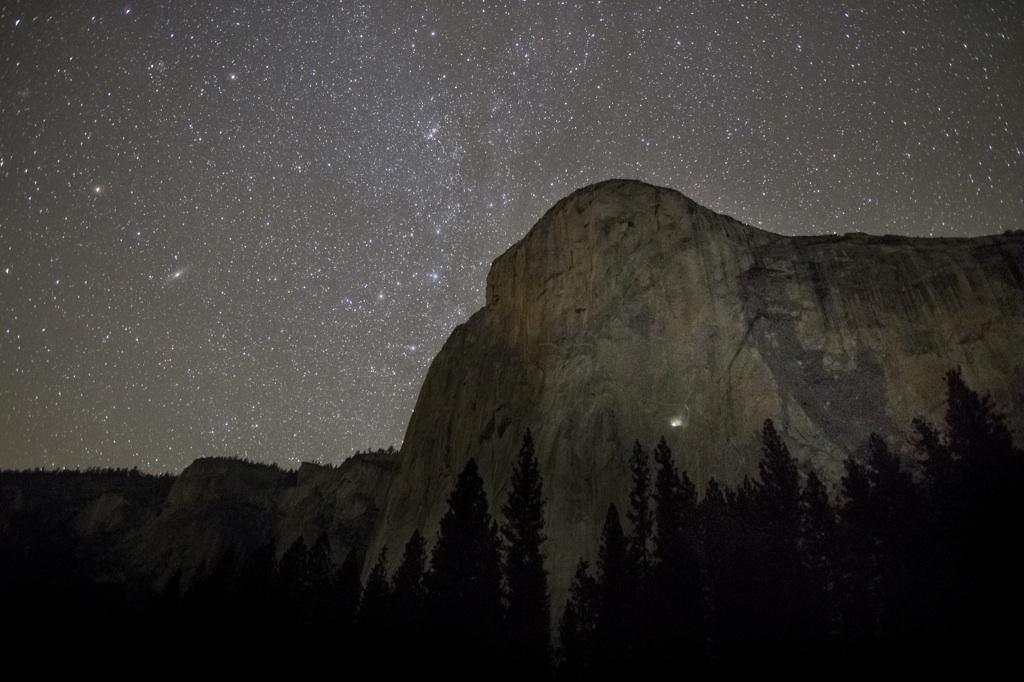
Wilderness Society Tweeted: Stars over Yosemite’s El Capitan (in honor of @kjorgeson & @tommycaldwell1). Have a good night! (Photo by Justin Kern, flickr)
Actually, this photo probably is not from the past few days, when Kevin Jorgeson and Tommy Caldwell worked to free climb the rock — but the Milky Way is there if they care to look!
Not just the whole world is watching — the whole universe shines down.
(Have you been following their climbing exploits?)
More:
Follow the climbers on Twitter, @kjorgeson and @tommycaldwell1
America’s first national monument, Devils Tower is a geologic feature that protrudes out of the rolling prairie in Wyoming. David Lane captured this amazing 16-image panorama of the monument illuminated by the Milky Way and green airglow. Of visiting Devils Tower, David says: “From ancient stories of the Pleiades taking refuge at the top to the generations of Native Americas that held it sacred, it had a deep sense of age and a stoic nature that impressed me. It’s so unexpected, so large in person, so steeped in traditions.”
Among many other things in his life, he was for a time a cowboy in South Dakota, in the area where today resides the Theodore Roosevelt National Park.
Look closely at the picture. You can almost see Teddy. He was a powerful, guiding force behind the movement to protect precious, historic, scientifically valuable and beautiful lands, by the federal government.
Happy birthday, Theodore Roosevelt! Let’s celebrate with a great shot of @TRooseveltNPS #NorthDakota
Or, until that account is unsuspended by the forces supporting Donald Trump: Follow @FillmoreWhite, the account of the Millard Fillmore White House Library
We've been soaking in the Bathtub for several months, long enough that some of the links we've used have gone to the Great Internet in the Sky.
If you find a dead link, please leave a comment to that post, and tell us what link has expired.
Thanks!
Retired teacher of law, economics, history, AP government, psychology and science. Former speechwriter, press guy and legislative aide in U.S. Senate. Former Department of Education. Former airline real estate, telecom towers, Big 6 (that old!) consultant. Lab and field research in air pollution control.
My blog, Millard Fillmore's Bathtub, is a continuing experiment to test how to use blogs to improve and speed up learning processes for students, perhaps by making some of the courses actually interesting. It is a blog for teachers, to see if we can use blogs. It is for people interested in social studies and social studies education, to see if we can learn to get it right. It's a blog for science fans, to promote good science and good science policy. It's a blog for people interested in good government and how to achieve it.
BS in Mass Communication, University of Utah
Graduate study in Rhetoric and Speech Communication, University of Arizona
JD from the National Law Center, George Washington University


 Posted by Ed Darrell