Yosemite Falls is the tallest waterfall in North America, and is a powerful presence in Yosemite Valley. From winter ice to spring flood to autumn dryness, this magnificent waterfall is a dynamic force of nature.
National Park Service photo of Upper Yosemite Falls
U.S. President Theodore Roosevelt (left) and nature preservationist John Muir, founder of the Sierra Club , on Glacier Point in Yosemite National Park in 1903. In the background: Upper and lower Yosemite Falls. (Photo credit: Wikipedia)
73,117
Spread the word; friends don't allow friends to repeat history.
U.S. Mint‘s Acting Associate Director for Manufacturing, David Croft delivers his remarks. — in Custer, SD.
Interesting view of Mt. Rushmore on the new Mt. Rushmore Quarter.
Here’s David Croft, Acting Associate Director for Manufacturing of the U.S. Mint, introducing the coin yesterday in Custer, South Dakota.
(Wow; how much history is packed in that? Too little of it in the high school texts. Who is on Rushmore? Who made the sculptures on Rushmore, and when? After whom is Custer, South Dakota, named, and why?)
Sign near Mt. Rushmore, South Dakota, informing travelers that the Alfred Hithcock film “North by Northwest” was partially filmed in the area (Photo credit: Wikipedia)
Spread the word; friends don't allow friends to repeat history.
Stunning southern night sky in Ofu Island in the National Park of American Samoa! They get a brighter, richer view of the Milky Way in the Southern Hemisphere due to the location on the globe. This is the only national park found in the Southern Hemisphere. Photo: National Park Service
Many Americans seem unaware of worldwide holdings of the U.S. in territories, thinking the last territory was closed when Oklahoma or Arizona entered the union, or maybe Alaska or Hawaii. U.S. territories today include the Northern Mariana Islands, Guam (from the Spanish American War), Puerto Rico (from the same war), and the U.S. Virgin Islands, as organized territories. American Samoa is an “unorganized territory,” along with series of other islands in the Pacific: Baker Island, Howland Island, Palmyra Atoll, Johnson Atoll, Jarvis Island, Kingman Reef, the Midway Islands, and Wake Island; and in the Caribbean, Bajo Nuevo Bank, Navassa Island (also claimed by Haiti), and Serranilla Bank, also claimed by Colombia.
Most of these islands offer much better star-gazing than is ever possible in Dallas.
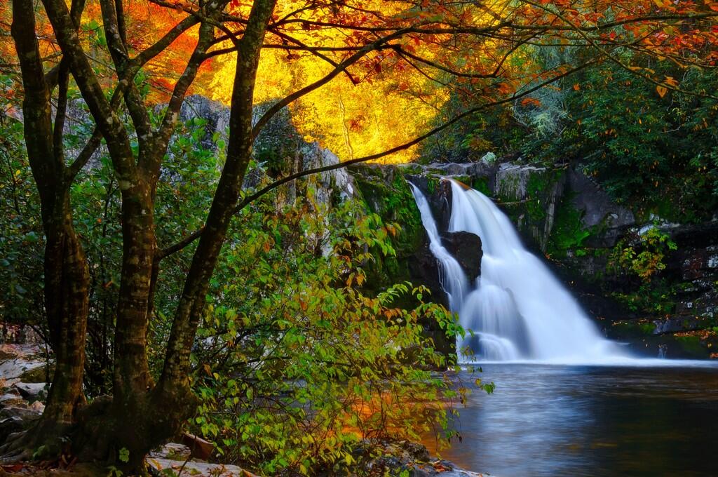
US Dept of Interior @Interior 16 Sep Department of Interior Tweet: It doesn’t get much prettier than this. Abrams Falls in Great Smoky Mountains National Park. #Tennessee pic.twitter.com/S5dQgcffEZ
Caption from America’s Great Outdoors: There are many unique areas within America’s public lands. Case in point this spot in Glen Canyon National Recreation Area. Photo: Cassandra Crowley
Horsetail Fall flows over the eastern edge of El Capitan in Yosemite Valley. It’s a small waterfall that many people don’t notice, but it has gained popularity as more and more people have noticed it can glow orange during sunset in mid to late February. The most popular place to see Horsetail Fall seemingly afire is El Capitan picnic area, west of Yosemite Lodge and east of El Capitan (see map below). The “firefall” effect generally happens during the second half of February. A clear sky is necessary for the waterfall to glow orange. Photo: Bethany Gediman, NPS
People living close to National Parks are lucky to do so; people who work in them luckier still, in the lifetime sweepstakes for seeing breathtaking sites. NPS employee (Ranger?) Bethany Gediman caught this image of Horsetail Fall in Yosemite National Park.
If you go today, vote before you go. This is one of the areas to be opened to energy exploration — oil and gas drilling or other mining — under Mitt Romney’s “energy plan” and the GOP National Platform.
National Parks really are a tiny part of the federal budget. Consequently, they get overlooked, and that could be bad.
How are your Congress and Senate candidates standing on these issues?
Romney’s “energy plan” calls for opening up the National Parks for oil and gas exploration and drilling, even the Flight 93 Memorial in Pennsylvania Bet that’s not mentioned by anyone in the debate tonight.
Which one is your favorite unit of the National Park System? What’s your favorite family story from visiting the parks? How are you going to vote in November?
Department of Interior tweeted that the photo was posted at Instagram — no other big details:
A full #moon rises over Mt. Everts near Mammoth Hot Springs in #Yellowstone National Park.
With more than 300 properties including the “Crown Jewels” of the National Parks, with employees carrying cell phones, it must be an interesting job to pick one photo to post on Instagram on any given day. I wonder who makes the selection.
(I wonder whether anyone will glance quickly, and misread “Mt. Everts” as “Mt. Everest.”)
Interior Department photo, America’s Great Outdoors, at Denali National Park and Preserve; photo caption from AGO said, “We’re not sure it’s possible to take a bad photo up there!” Click for larger view.
Update: Interior tweeted another photo later today.
From the U.S. Department of Interior Tweet: This morning we gave you an amazing shot of #Denali. Would you believe this one is from the same place? Whether large or small, beauty in Denali is everywhere you look. #Alaska
Can someone identify the flower?
Spread the word; friends don't allow friends to repeat history.
U.S. flag and Denali on an almost-clear day; Department of Interior photo, August 2012 – public domain
usinterior Tweeted, “Does it get any better than this?”
Denali, also known as Mt. McKinley, is the highest point in North America, 20,320 feet (6,194 m) above sea level. Measured base to peak, it’s the tallest mountain on land on Earth — Everest and other Himilayan peaks rise from a very high plateau. Denali is high enough that it makes its own weather. Finding a day when the mountain is not almost completely obscured by clouds is rare, locals say. Finding an almost-clear view, with blue sky in the background, is a cause for photographer excitement.
You’ll notice straight-line clouds in the sky — condensation trails from passenger jets. I wonder how many flights bend a little to get a better view of the mountain for passengers? Do big airlines even do that anymore?
Nice shot. I could learn to like Instagram with more photos of this quality.
Better, it would be nice to be there, taking these shots.
More, including the controversy over the mountain’s name:
John Muir’s place in American history endures constant assault. Not only did businessmen and politicians of his own day find Muir’s policies anathema to their hopes of profiting from the destruction of the American wild, so today do we hear that profits cannot be had without the rape of the environment.
Muir knew better, and so should you!
On July 19, 1869 — in the middle of the administration of U. S. Grant, Muir began his journals on the beauty of life in the Sierras, to be published 42 years later as My First Summer in the Sierra.
It should be required reading in more American classrooms:
John Muir
Watching the daybreak and sunrise. The pale rose and purple sky changing softly to daffodil yellow and white, sunbeams pouring through the passes between the peaks and over the Yosemite domes, making their edges burn; the silver firs in the middle ground catching the glow on their spiry tops, and our camp grove fills and thrills with the glorious light. Everything awakening alert and joyful…John Muir, Entry for “July 19“ from My First Summer in the Sierra, 1911. “California As I Saw It”: First-Person Narratives of California’s Early Years, 1849-1900
On July 19, 1869, naturalist John Muir set pen to paper to capture his experience of awakening in the Sierra Nevada Mountains of California. Published in 1911, My First Summer in the Sierra is based on Muir’s original journals and sketches of his 1869 stay in the vicinity of the Yosemite Valley. His journal tracks his three-and-a-half-month visit to the Yosemite region and his ascent of Mt. Hoffman and other Sierra peaks. Along the way, he describes the flora and fauna as well as the geography and geology of the area.
Muir immigrated from Scotland to Wisconsin as a child. He attended the University of Wisconsin and began working as a mechanical inventor. After an 1867 industrial accident nearly blinded him, he abandoned his career as an inventor to work as a naturalist.
An early defender of the environment, Muir in 1876 advocated adoption of a federal forest conservation program. His popular articles and books describing Yosemite’s natural wonders inspired public support for the establishment of Yosemite National Park in 1890 and expansion of the park in 1906. At the same time, Muir continued to work and write as a serious scientist whose fieldwork in botany and geology enabled him to make lasting contributions. Alaska’s Muir Glacier is named for him. In 1892, Muir co-founded the as an association explicitly dedicated to wilderness preservation and served until 1914 as its first president, shaping it into an organization whose leadership in political advocacy for protection of the natural world continues to this day.
The popularity of President Theodore Roosevelt’s groundbreaking conservation program owed much to Muir’s writing. In 1903 Roosevelt and Muir visited the Yosemite region together. In 1908, Roosevelt issued a presidential proclamation establishing the Muir Woods National Monument in Marin County, California, in Muir’s honor. Muir died six years later. Although sorrow and disappointment at his failure to save Hetch Hetchy Valley from becoming a reservoir for San Francisco may well have contributed to his death, Muir had succeeded more than any other single individual in establishing the preservation of wild nature as a major American cultural and political value. The clarity of his vision and the eloquence of his writing continue to inspire environmentalists throughout the world.
Learn more about John Muir and the conservation movement in American Memory:
Visit the ‘s . This fascinating presentation provides a wealth of information and links, including many photographs, a wide selection of electronic texts written by and about John Muir, and sound clips of songs written about or inspired by Muir’s work. Yosemite National Park Wildflowers,
Yosemite National Park,
California. American Landscape and Architectural Design, 1850-1920
Search on Yosemiteor the name of other national parks in the following collections to see more images of America’s natural wonders:
For access to current environmental protection bills under consideration in the U.S. House of Representatives and the Senate, visit THOMAS and browse major legislation classified by topic using terms such as environmental protection or public lands.
Spread the word; friends don't allow friends to repeat history.
Among other things one might observe from this film, one might note that Yosemite National Park’s beauty is so great that it looks good from almost any angle, even with tourists plastered all over it.
This was released between Yosemite Nature Notes #14 and #15, and I find no other description. This remains a wonderful series showing off the geography and natural phenomena of Yosemite. I wish there were similar programs for Yellowstone, Glacier, Denali, Grand Canyon, Zion, Bryce, Big Bend, Great Smoky Mountains, and for the Adirondack State Park in New York, among many others.
Spread the word; friends don't allow friends to repeat history.
One of what should be an occasional series of posts on American iconic places, natural features, sights to see, etc. For studies of U.S. history and U.S. geography, each of these posts covers subjects an educated American should know. What is the value of these icons? Individually and collectively, our preservation of them may do nothing at all for the defense of our nation. But individually and collectively, they help make our nation worth defending.
This is a less-than-10-minute video you can insert into class as a bell ringer, or at the end of a class, or as part of a study of geologic formations, or in any of a number of other ways. Yosemite Nature Notes provides glorious pictures and good information about Yosemite National Park — this video explains the modern incarnation of Half Dome, an enormous chunk of granite that captures the imagination of every living, breathing soul who ever sees it.
Potential questions for class discussion:
Have you put climbing Half Dome on your bucket list yet? Why not?
Is it really wilderness when so many people go there?
How should the National Park Service, and the Forest Service and Bureau of Land Management, manage these spectacular, completely unique features, both to preserve their wild nature, and allow people to visit them?
What are the federalism issues involved in protecting Half Dome, or any grand feature, like the Great Smokey Mountains, Great Dismal Swamp, Big Bend, Yellowstone Falls, or Lincoln Memorial?
Or, until that account is unsuspended by the forces supporting Donald Trump: Follow @FillmoreWhite, the account of the Millard Fillmore White House Library
We've been soaking in the Bathtub for several months, long enough that some of the links we've used have gone to the Great Internet in the Sky.
If you find a dead link, please leave a comment to that post, and tell us what link has expired.
Thanks!
Retired teacher of law, economics, history, AP government, psychology and science. Former speechwriter, press guy and legislative aide in U.S. Senate. Former Department of Education. Former airline real estate, telecom towers, Big 6 (that old!) consultant. Lab and field research in air pollution control.
My blog, Millard Fillmore's Bathtub, is a continuing experiment to test how to use blogs to improve and speed up learning processes for students, perhaps by making some of the courses actually interesting. It is a blog for teachers, to see if we can use blogs. It is for people interested in social studies and social studies education, to see if we can learn to get it right. It's a blog for science fans, to promote good science and good science policy. It's a blog for people interested in good government and how to achieve it.
BS in Mass Communication, University of Utah
Graduate study in Rhetoric and Speech Communication, University of Arizona
JD from the National Law Center, George Washington University

 and n...")


 Posted by Ed Darrell


")


