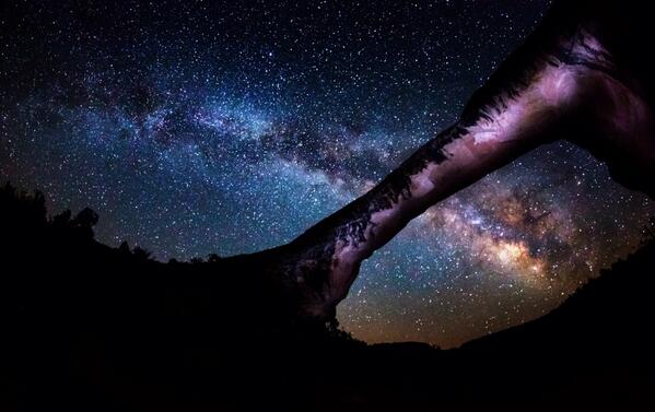
From the Department of Interior’s Twitter feed: Looking for a wow photo? This picture of the Milky Way over Natural Bridges Natl Monument should do the trick. pic.twitter.com/RfuDj7KXSA
Owachomo Bridge? Photographer? I wish Interior would put in all the details with their photos.
Spread the word; friends don't allow friends to repeat history.
U. S. Department of Interior on Twitter: Amazing photo of a night heron in J.N. “Ding” Darling NWR by intern Libby Errickson. @USFWSSoutheast #Florida pic.twitter.com/PA04nE4hhD
Let me count the ways I love it:
It’s a great photo, of a beautiful bird — a pose you won’t see often.
An intern took it. Management of our great natural treasures, the Wildlife Refuges, the National Parks, the National Monuments, is flat enough that an intern can get great experience, and spend a lifetime — and score a great picture that the poobahs in Washington like and promote. It’s a career photo; let’s hope Libby Errickson has (or had) a great internship, and this is just the first of many career photos or studies or whatever.
At a time when federal management of public lands is under fire, generally unjustifiably, simply for doing a good job but not having billionaires running their press operations, this is one more small example of something done right, for a long time. The J. N. “Ding” Darling National Wildlife Refuge is one of the oldest in the U.S. It was created by Executive Order from President Harry Truman in 1945, and is now one of more than 500 units of National Wildlife Refuges under the management of the U.S. Fish and Wildlife Service, and other federal agencies.
Bonus: Ding Darling was a political cartoonist, and a conservationist. His pen, in pictures and words, convinced authorities to stop the sale and development of Sanibel Island in the Gulf of Mexico, preserving unique and valuable bird habitat. This refuge celebrates one of our greatest political cartoonists. It was renamed from Sanibel to Ding Darling NWR in 1967. If you ask me, we don’t honor our political cartoonists enough.
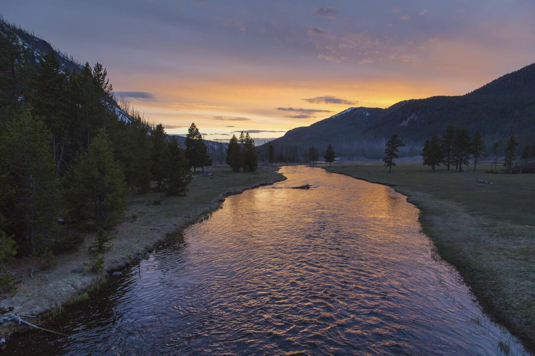
Photo after photo, I come increasingly to understand why my oldest brother, Jerry, wanted to spend his life and eternity in the Yellowstone.
Wholly apart from the thermal “features” and geological wonders, the area is just smashingly beautiful day in and day out, in even the mundane areas away from the celebrated features.
Here’s a part of the Madison River, just flowing through its streambed, at sunset.
Yellowstone National Park’s Twitter feed: Spring sunset on the Madison River. pic.twitter.com/8nZSxJvBeZ
Spread the word; friends don't allow friends to repeat history.
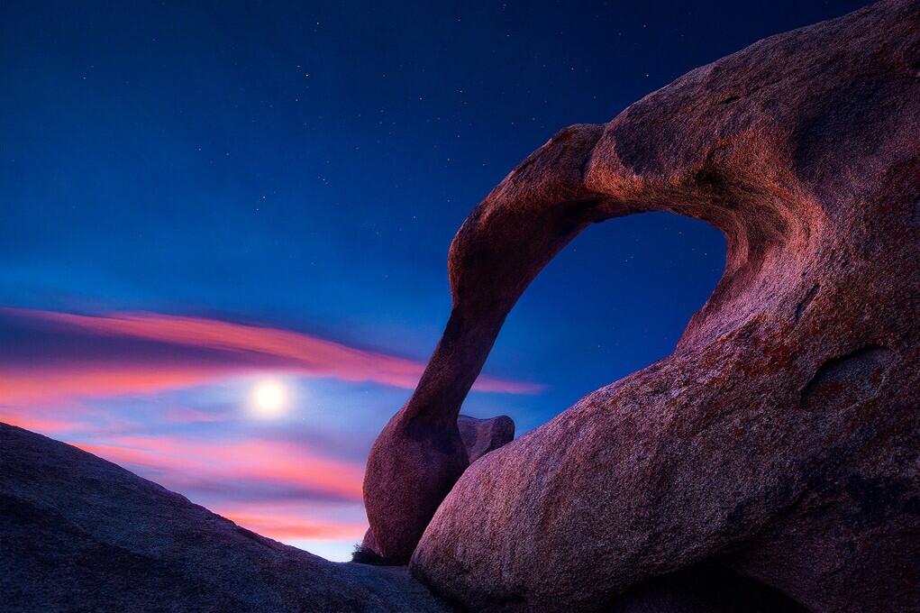
U.S. Department of Interior, Twitter feed: Beautiful view of the Moon over Mabius Mobius Arch in the Alabama Hills Recreation Area. #California @BLMca pic.twitter.com/u0KYyJ6p0S
Interesting points, reasons to like this image:
No, that’s not the Sun. It’s the Moon.
Who knew California had natural arches? I mean, it makes sense — but there’s one in Virginia, and a bunch of them at Arches National Park, and . . .
An arch that should be in Utah, in the Alabama Hills, but not in Alabama, in California.
America’s public lands, showing how they are unexcelled at astonishing us.
What? Interior called the “Mabius Arch?” No, it’s the Mobius Arch!
This place was named after the Confederate warship C.S.S. Alabama. Sympathetic miners making claims on minerals, it appears. “The unusual name Alabama Hills came about during the Civil War. In 1864 Southern sympathizers in Lone Pine discovered gold ‘in them thar hills.’ When they heard that a Confederate cruiser named the Alabama had burned, sunk or captured more than 60 Federal ships in less than two years they named their mining claims after the cruiser to celebrate. Before long the name applied to the whole area. Coincidentally, while Southerners were prospecting around Lone Pine, there were Union sympathizers 15 miles north near Independence. And when the Alabama was sunk off the coast of France by the U.S.S. Kearsarge in 1864, the Independence people struck back. They not only named their mining claims ‘Kearsarge’ but a mountain peak, a mountain pass, and a whole town as well.”
Geologists will love that this area is a prime example of chemical erosion — rocks made out of the same stuff as the craggy Sierra Nevada Mountains in the distance, but eroded differently.
Lichens by moonlight! (Or is that just desert varnish?)
More:
Alabama Hills Recreation Area: “On May 24, 1969, the BLM dedicated nearly 30,000 acres of public land west of Lone Pine, CA, as the Alabama Hills Recreation Area. Management plans are being considered that will eventually include a scenic trail system that people may walk and enjoy this geologic phenomena at a leisurely pace.“
Milky Way over Monument Valley Navajo Tribal Park. Photo by Gavin Heffernan and Harun Mehmedinović, from the video (which also features Grand Canyon National Park)
And that they do. The Milky Way is the star of the show; the galactic bulge, disk, and dark fingers of vast dust lanes as clear as if this were taken from space. Well, sort of; I was impressed by the mix of clouds and sky, to be honest. The contrast was interesting, and it’s rather amazing the Milky Way could stand out so clearly above the cloud line.
One thing I want to point out specifically: At 2:10 in, a meteor flashes and leaves behind a curling wisp of what looks like smoke. This is called a persistent train, the vaporized remains of the meteoroid itself, and can glow for several minutes. The upper level winds from 60–100 km above Earth’s surface are what blow it into those curlicues.
More details, for more films from these guys:
Shot and Produced by: Gavin Heffernan and Harun Mehmedinović
Music: A Seated Night (Ambient) by Moby. Courtesy MobyGratis.com / Unknown Native Chant
Thanks: Northern Arizona University, Grand Canyon National Park, Monument Valley Tribal Park.
One way to get the kids out of their sleeping bags in the morning, no? Just alert them to the passing California condor, looking for something that doesn’t move, to eat.
USFWS PacificSouthwest: “Now that is up close and personal! Melissa Galieti snapped this picture of #Condor 470 ‘Fuego,’ May 5 in Big Sur, California. pic.twitter.com/QKvURadqaV
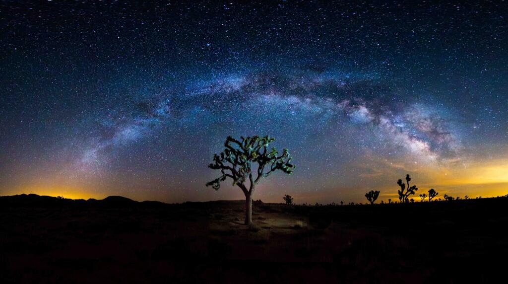
From the U.S Department of Interior Twitter feed: To celebrate being named to the @TIME #Twitter140, here is an amazing photo from @JoshuaTreeNP. pic.twitter.com/F4DS5Xv9vq
Passenger jet and Moon. Photo by Rodger Schmitt, from Lake Powell, Utah.
Handheld Nikon. Nikon stabilizing lens. Good hands, I’d say.
Third to last time I was out near Lake Powell, I was with Rodger (and about a dozen others) organizing hearings of the President’s Commission on Americans Outdoors. We flew into Page, Arizona, on an Otter II coming up from Phoenix flying low, looking for elk, and legally buzzing Rainbow Bridge (impressive from the air, too).
We had a luncheon meeting at Wahweap Marina, as I recall; no time for boating.
Then we were off to the South Rim of the Grand Canyon. There we inspected pine trees 30 feet tall, growing between the ties of the then-abandoned rail lines. (And did a lot of other stuff.)
Today trains carry tourists to the South Rim on those tracks, the trees gone. Progress, really.
Rodger carries on in the knowledge that use of the outdoors, especially these public lands, heals souls, and sometimes gives you great photos.
Rodger said I could borrow the photo. Thanks!
Spread the word; friends don't allow friends to repeat history.
Here’s just exactly the sort of thing that happens in nature that drives creationists nuts. How could this happen without God personally working to confuse and/or delight the photographer? Not to mention the physicist and mathematician.
Photo from the Twitter feed of Science Porn: “Go home waves you’re drunk. This is called cross sea btw pic.twitter.com/5Cv1UUo8QX”
Where? Somewhere in France, one might gather from the flag on the structure (lighthouse?).
Crossing swells, consisting of near-cnoidal wave trains. Photo taken from Phares des Baleines (Whale Lighthouse) at the western point of Île de Ré (Isle of Rhé), France, in the Atlantic Ocean. The interaction of such near-solitons in shallow water may be modeled through the Kadomtsev–Petviashvili equation.
Oh, you remember that one, don’t you? The Kadomtsev–Petviashvili equation?
At least we confirmed it was taken in France.
They do everything differently in France, don’t they?
Update:Got an e-mail suggestion that I include the equation itself. You may certainly click to Wikipedia to find it; here’s what it says over there:
where . The above form shows that the KP equation is a generalization to two spatial dimensions, x and y, of the one-dimensional Korteweg–de Vries (KdV) equation. To be physically meaningful, the wave propagation direction has to be not-too-far from the x direction, i.e. with only slow variations of solutions in the y direction.
Upper and Lower Antelope Canyon, near Page Arizona, get more visitors annually than just about any other canyon except the Grand Canyon. They cover only a few miles.
You’re not familiar with Antelope Canyon? You’ve seen the photos, even if you don’t know the name of the place — it’s a slot canyon, carved as with a wandering knife into the sandstone at the top of the cliffs leading to the Colorado River.
Sergio Garcia Rill captured this beautiful image from within Upper Antelope Canyon in Arizona, which is the most visited slot canyon in the United States. A slot canyon is significantly deeper than it is wide. It’s formed by water rushing through rock. Sergio wrote:
During my recent trip to Arizona, I stopped by Page to get a chance at touring the now famous canyons (Upper and Lower Antelope) and I also had a chance to visit Upper Antelope at night.
I couldn’t really get too many shots with the sky (since the openings were very narrow and limited) but I liked this one in particular since I got a chance to set it up and do the light painting myself a couple of chambers behind from where my guide and another participant were working on another shot.
Readers here may remember Page was the final destination of my late oldest brother, Jerry. To his credit, he urged me to make a special trip to see Antelope Canyon, because most of the times I visited, it was closed, or impassable. Alas, I have not yet been to the place.
This is one of the gems of the Diné, the Navajo Nation, and another good reason to get familiar with redrock country.
Spread the word; friends don't allow friends to repeat history.
Photo from the Dallas Karting Complex. Dallas, evening of March 27, 2014. Photographer unidentified. David Worthington.
Funny thing is, this photo probably didn’t require much processing to look like this. Advances in lighting, especially LEDs and color, mean that Dallas’s skyline can look much like this any night.
Just add a thunderhead to the northeast, and voila!
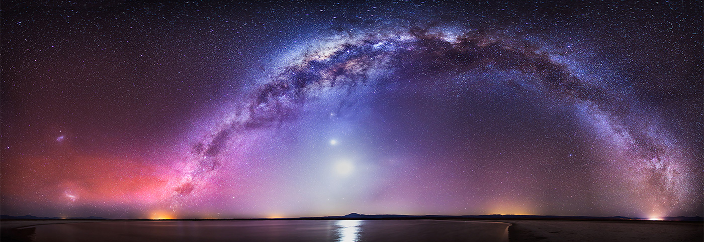
Found on Twitter, via @SciencePorn – One of the most beautiful pictures I’ve ever seen. Star photography by Nicholas Buer pic.twitter.com/RlwvSQNBAy. Much larger view here.
This one was the Astronomy Picture of the Day (APOD) for January 27, 2014 (click that link for a much larger and more glorious view). Much more detail there, revealing that this is much more of the Milky Way than you’d usually see.
From the Northern to the Southern Cross Image Credit & Copyright: NicholasBuer Explanation: There is a road that connects the Northern to the Southern Cross but you have to be at the right place and time to see it. The road, as pictured above, is actually the central band of our Milky Way Galaxy; the right place, in this case, is dark Laguna Cejar in Salar de Atacama of Northern Chile; and the right time was in early October, just after sunset. Many sky wonders were captured then, including the bright Moon, inside the Milky Way arch; Venus, just above the Moon; Saturn and Mercury, just below the Moon; the Large and Small Magellanic Clouds satellite galaxies, on the far left; red airglow near the horizon on the image left; and the lights of small towns at several locations across the horizon. One might guess that composing this 30-image panorama would have been a serene experience, but for that one would have required earplugs to ignore the continued brays of wild donkeys.
Save
Spread the word; friends don't allow friends to repeat history.
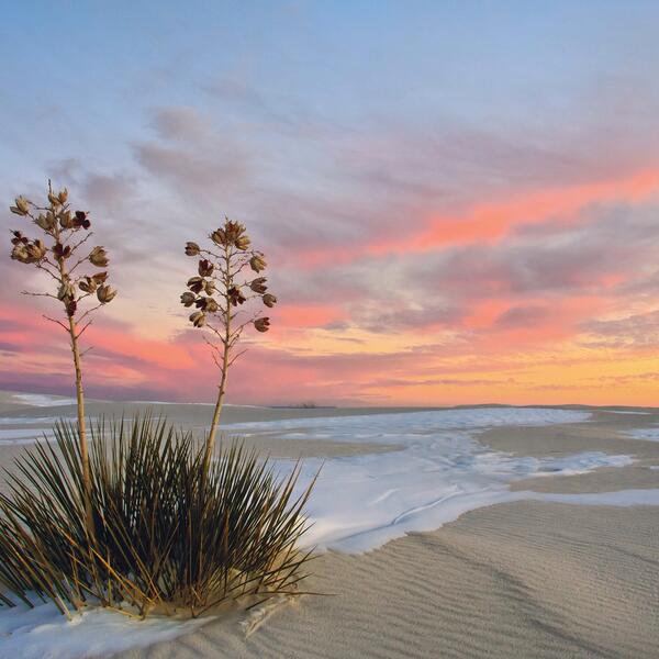
Department of Interior Great American Outdoors Tumblr caption: One of the world’a great natural wonders – the glistening white sands @WhiteSands_NPS. #NewMexico pic.twitter.com/dbzPpIfSRW
One of the problems of touring places like White Sands National Monument is that most tourists arrive mid-day; most spectacular views are probably close to sunrise or sunset, when the sky adds colors other than “bright” to the scene.
Rising from the heart of the Tularosa Basin is one of the world’s great natural wonders – the glistening white sands of New Mexico. Great wave-like dunes of gypsum sand have engulfed 275 square miles of desert, creating the world’s largest gypsum dunefield. White Sands National Monument preserves a major portion of this unique dunefield, along with the plants and animals that live here.
Yes, the same White Sands where the Trinity Project first triggered an atomic weapon, in 1945 — but the blast site is actually about 100 miles north of the National Monument on the military’s White Sands Missile Range. Historical reasons to visit, as well as nature and beauty reasons.
I assume that’s some sort of yucca in the photo; can you tell more specifically?
Or, until that account is unsuspended by the forces supporting Donald Trump: Follow @FillmoreWhite, the account of the Millard Fillmore White House Library
We've been soaking in the Bathtub for several months, long enough that some of the links we've used have gone to the Great Internet in the Sky.
If you find a dead link, please leave a comment to that post, and tell us what link has expired.
Thanks!
Retired teacher of law, economics, history, AP government, psychology and science. Former speechwriter, press guy and legislative aide in U.S. Senate. Former Department of Education. Former airline real estate, telecom towers, Big 6 (that old!) consultant. Lab and field research in air pollution control.
My blog, Millard Fillmore's Bathtub, is a continuing experiment to test how to use blogs to improve and speed up learning processes for students, perhaps by making some of the courses actually interesting. It is a blog for teachers, to see if we can use blogs. It is for people interested in social studies and social studies education, to see if we can learn to get it right. It's a blog for science fans, to promote good science and good science policy. It's a blog for people interested in good government and how to achieve it.
BS in Mass Communication, University of Utah
Graduate study in Rhetoric and Speech Communication, University of Arizona
JD from the National Law Center, George Washington University


 Posted by Ed Darrell
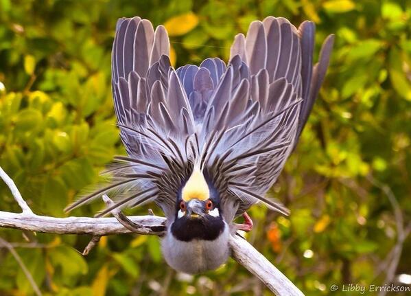


 . The above form shows that the KP equation is a generalization to two


