As ordered reported by the Senate Committee on Energy and Natural Resources on June 18, 2013.
CBO estimates that enacting this legislation to name a peak in Alaska would have no significant impact on the federal budget and would not affect direct spending or revenues; therefore, pay-as-you-go procedures do not apply. S. 155 contains no intergovernmental or private-sector mandates as defined in the Unfunded Mandates Reform Act and would not affect the budgets of state, local, or tribal governments.
Calling a mountain by its name won’t affect the budget? Good news, I’m sure. Shakespeare was right.
STATEMENT OF PEGGY O’DELL, DEPUTY DIRECTOR FOR OPERATIONS, NATIONAL PARK SERVICE, DEPARTMENT OF THE INTERIOR, BEFORE THE SUBCOMMITTEE ON NATIONAL PARKS OF THE SENATE ENERGY AND NATURAL RESOURCES COMMITTEE, CONCERNING S. 155, TO DESIGNATE A MOUNTAIN IN THE STATE OF ALASKA AS DENALI.
April 23, 2013
Mr. Chairman, thank you for the opportunity to present the Department of the Interior’s views on S. 155, a bill to designate a mountain in the State of Alaska as Denali.
The National Park Service appreciates the long history and public interest for both the name Mount McKinley and the traditional Athabascan name, Denali. The Department respects the choice made by this legislation, and does not object to S. 155.
Located in what is now Denali National Park and Preserve, the highest peak in North America has been known by many names. The National Park Service’s administrative history of the park notes that, “The Koyukon called it Deenaalee, the Lower Tanana named it Deenaadheet or Deennadhee, the Dena’ina called it Dghelay Ka’a, and at least six other Native groups had their own names for it.
“In the late 18th century various Europeans came calling, and virtually everyone who passed by was moved to comment on it. The Russians called it Bulshaia or Tenada, and though explorers from other nations were less specific, even the most hard-bitten adventurers were in awe of its height and majesty.
“No American gave it a name until Densmore’s Mountain appeared in the late 1880s, and the name that eventually stuck—Mount McKinley—was not applied until the waning days of the nineteenth century,” a gesture of support to then-President William McKinley.
In 1975, the State of Alaska officially recognized Denali as the name of the peak, and requested action by the U.S. Board on Geographic Names to do the same.
In 1980, Congress changed the name of Mount McKinley National Park to Denali National Park and Preserve (P.L. 96-487, Section 202), but did not act on the name change for the mountain.
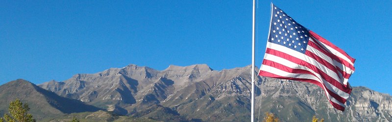
Mt. Timpanogos and the U.S. flag. Photo by Bob Walker of Orem, Utah; from Orem, circa September 2012. That’s Mt. Baldy on the left. This site is about six miles from our old home in Pleasant Grove, Utah.
Mount Everest North Face as seen from the path to the base camp, Tibet. Wikipedia image
A pick from the staff at Vimeo.
It’s astonishing how many people ascend Mt. Everest in our time. Look at the tent city.
Everest’s beauty is stunning, always has been, but is now revealed by high-definition image capture unavailable just 10 years ago, now distributed by the internet.
These photos are mostly from about 25,000 feet in elevation — about where much domestic U.S. air travel occurs. The weather up there is spectacular, if you’re not in it. It’s spectactular if you’re in it, too — but I’m viewing it from Dallas, where we’re above 90 degrees in the day, now, just 800 feet above sea level.
One of the most rewarding parts of the journey was being able to share it with thousands of students on epals.com/everest
This time lapse video is comprised of thousands of photographs, processed and assembled on Mt. Everest.
Shot on a Canon 5D Mark II
-Canon 2.8 16-35mm
-Canon 2.8 24-70mm
-Canon 2.8 70-200mm (which was way to heavy to carry beyond 6400M)
-TL Remote was purchased off eBay
Edited in Final Cut Pro
Processed in Adobe LightRoom
Movies compiled in Quicktime
Feynman and the famous C-clamp experiment — in a glass of ice water — demonstrating how rubber O-rings failed in launch, at the Challenger Commission. (Why are there so few good photos of this event?)
Geography and history teachers, you should watch this on the day after Feynman Day. Can you make use of this in your classes — say, after the state tests?
How about you physics and science teachers?
Tuvan People’s Republic, marked in green. Wikipedia image
In 1998 NOVA produced and broadcast a film that rather defies categorization. Biography? Drama? Humor? Frustrated travelogue?
“Last Journey of a Genius” tells a lot of biography of Dick Feynman, but it focuses on his unusual drive to learn about, and travel to an obscure Central Asian country/province/area/culture called Tannu Tuva. Feynman’s close friend Ralph Leighton plays a big role in this film, too. This film reveals more about the character of Richard Feynman, his overwhelming curiosity and humanity, than you can get any other place, including his memoirs (which every civil human should read).
NOVA captivates me almost every week. Good fortune found me in front of a television somewhere when this was first broadcast. For several reasons, I’ve been unable to get a VHS, or a DVD version of the story despite many attempts over the years.
But fortune and good history smile again. Open Culture collected the film, and it’s available for free in their documentary section.
Drumming, story telling, geography, Cold War politics, ballet, more drumming, some nuclear physics, astronomy, a lot of good humor, and a plea for orange juice. It still makes me smile.
In 1989, PBS’ NOVA aired The Last Journey of a Genius, a television film that documents the final days of the great physicist Richard Feynman and his obsession with traveling to Tannu Tuva, a state outside of outer Mongolia, which then remained under Soviet control. For the better part of a decade, Feynman and his friend Ralph Leighton schemed to make their way to Tannu Tuva, but Cold War politics always frustrated their efforts. The video runs roughly 50 minutes and features an ailing Feynman talking about his wanderlust and their maneuverings. He died two weeks later, having never made the trip, though Ralph Leighton and Feyman’s daughter Michelle later landed in their Shangri-La. Her journey was recorded by the Russian service of the BBC.
The film now appears in the Documentary section of our collection of Free Movies Online.
Hang on to this link for Feynman Day 2014 (May 11). What’s your favorite Feynman story?
This kind of history and science is exactly the sort of stuff CSCOPE critics in Texas, and critics of the Common Core standards, worry that children will see. Very odd, because stuff this good is not even mentioned in CSCOPE, nor in CCSS.
Tip of the old scrub brush to Kenny Darrell, who found this film and let me know about it.
L. Banks illustrated a publication about an ancient bowl found at the Burnt City, in what is now Iran.
It’s a nice rendering of . . . gee, what is that?
If you remember correctly, it’s a goat. It’s a goat.
More specifically, it’s the goat depicted on “the world’s oldest animation,” a bowl more than 5,000 years old that some researchers think may have been the earliest attempt to depict animals in motion.
I wrote about the bowl back in 2008. I learned of it from Kris Hirst at About.com, and I thought it was interesting. “Animation” in the headline, at spring break, and tens of thousands of kids took a look at the little .gif animation from photos of the bowl. The post took about ten minutes to compose, and it remains the single most popular post ever at Millard Fillmore’s Bathtub (even more popular than the posts about the imaginary Texas chainsaw massacre).
So I stumbled on Banks’s drawing. Illustration is often high art — the image above is identified as an educational image. Children’s book? Don’t know.
Banks has some other very nice illustrations on display, on completely different subjects. You should go see.
What was that bowl maker trying to show with the goat and tree on that bowl? Did s/he dream that people would be making images inspired by the bowl, 52 centuries later?
An animated .gif made from photographic images of a bowl found at the Burnt City, and dated at 5,200 years.
Spread the word; friends don't allow friends to repeat history.
Our goldfinches left several weeks ago. The cedar waxwings came through in at least three big waves, starting in February (and the last just over a week ago). House finches moulted, and the breeding males have bright red heads. Migrating robins left us by the end of January, but a lot more residents stayed with us.
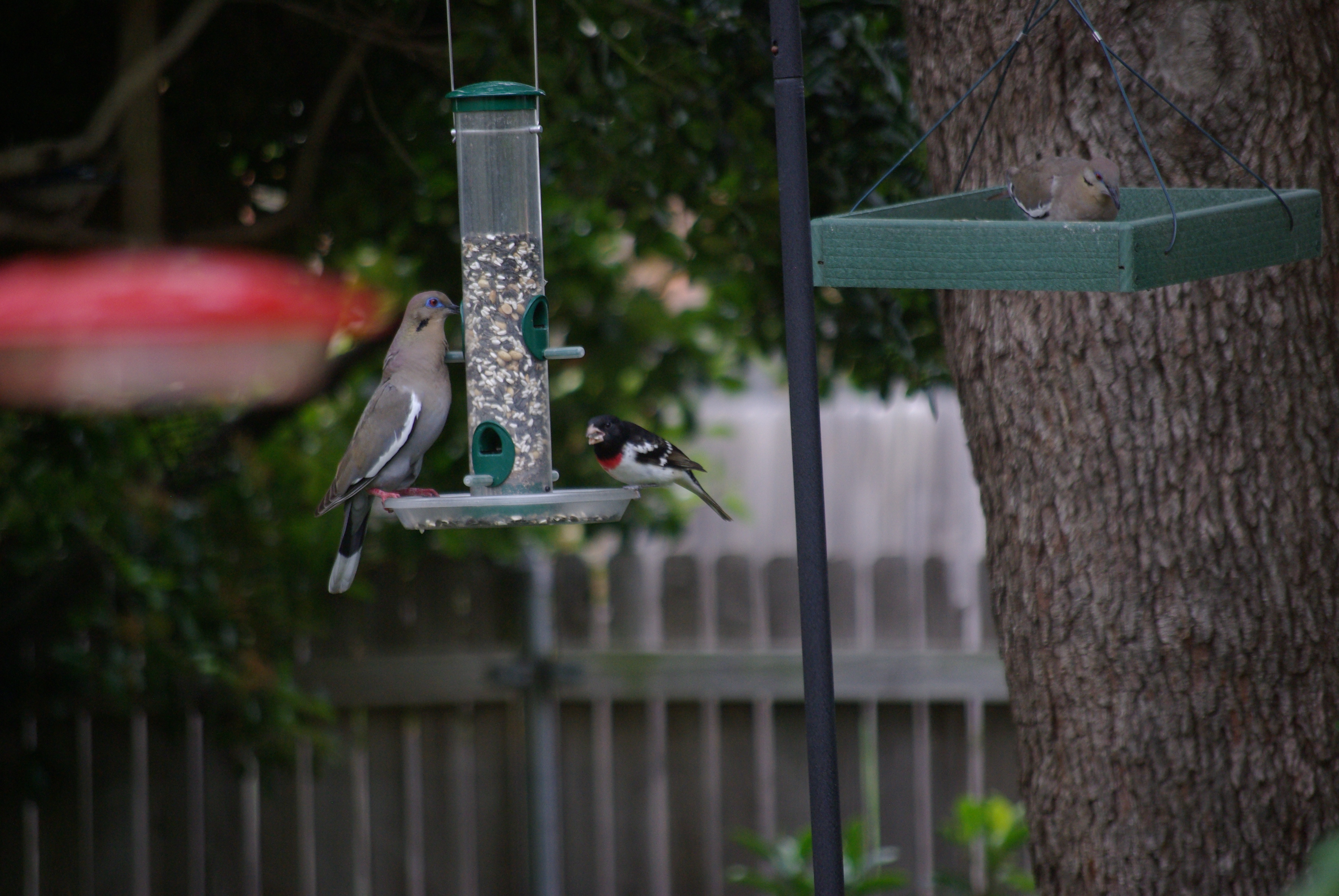
We have at least one, and maybe three cardinal families. A black-capped chickadee family stuck around. Haven’t seen a titmouse in a month, but I think they’re still in the neighborhood. The black-chinned hummingbird family is back, and maybe a few other hummers. The resident blue jays and white-winged doves duke it out every day. Carolina wren stayed, and may have already fledged; but there are too many wrens for one family — is that a Bewick’s wren?
What’s THAT?
White-winged dove, left, can’t scare away the rose-breasted grosbeak from the songbird feeder. Photo by Ed Darrell
Look closer. Photo by Ed Darrell
It’s a rose-breasted grosbeak, Pheucticus ludovicianus. It seems late for migrating birds, but only because so many migratory species migrate earlier these days.
Haunts of the rose-breasted grosbeak, from Cornell University’s ornithological laboratory.
Would love to have a grosbeak family, but the Cornell ornithologists say this is fly-through territory. Maybe that explains why it won’t scare by the white-winged dove,Zenaida asiatica. Dallas is the western edge of the grosbeaks’ migratory path, but the eastern edge of the dove’s territory. They probably don’t see much of each other.
See this United Nations Development Program ten-minute video that, to the wise and concerned, lays out the stakes of delaying action against human-caused climate change.
Without enough funding, NGOs work to help farmers getting hammered in the Southern Philippines, and other places.
In the Southern Philippines, farmers’ lives and the weather are intimately interwoven, but something is changing, now that the rains in Agusan del Norte are too heavy, the sun shines too fiercely. Now there’s hope for poor farmers with the community-based approach monitoring and Weather Index-Based Insurance packages, to warn people when heavy weather is on the way.
Though, I do weary of the astonishing abuse of acronyms in this work-of-the-angels. “WIBI?”
Incidentally, though the phrase doesn’t appear anywhere in this material, this is exactly the sort of work carried on by the UN’s Agenda 21 project. Doesn’t look subversive to me.
Tip of the old scrub brush to the UNDP and ILO Tweet:
More Iceland than Aurora. Not necessarily bad. Great timelapse photos.
You have my permission to turn down the music volume.
Filmmaker Anna Possberg wrote:
Iceland has become a popular destination since the singer Björk made her island famous by her songs. Yet few people know Iceland during wintertime. And I am sure that they miss a beautiful part of the island: the snow covered rocks, the magic arctic light and especially the phantastic aurora borealis dancing in the sky. The days spent at the Jokülsarlon glacial lake were one of the most beautiful and peaceful Christmas time I remember.
Jökulsárlón, a glacial lake in Iceland. To the right, the mouth of the glacier Vatnajökull. Wikipedia photo
Loren Holmes photograph straight up of Aurora borealis over Eureka, Alaska, on March 13, 2013. AlaskaDispatch.com
I love fireworks. Kathryn and I have been known to drive a couple hundred miles to see a good show. Fireworks in honor of the guy who gave us the Constitution and the First Amendment (and much more), seems a great idea to me.
But no one did it . . .
Sometimes the Sun, Moon, stars and planets conspire.
Here’s one of the best, most inspiring five minutes you’ll spend this week. Look what the Sun sent us, filmed in time-lapse glory above Eureka, Alaska, on March 16, 2013, the anniversary of James Madison’s birthday; from AlaskaDispatch.com:
A timelapse of the Aurora Borealis, Northern Lights, over Eureka, Alaska on March 16, 2013. Taken with a Canon 5D Mark III and 24mm f/1.4 and 70-200 f/2.8 lenses. Compiled from 3800 images, with exposures between 2 seconds and 30 seconds.
I shot this film over 4 trips to NYC 2011-2012. The time-lapse sequences you see here were made (mostly) from hundreds of thousands of still images. A Canon 7D and T3i were the main cameras, with backup from a couple of older Nikon Coolpix 5000 point and shooters. A few clips are sped-up video.
Many thanks to the generosity of the musician/composer who allowed his great celtic track “Sawjig” to be used;
Ben Rusch aka Jasmine Brunch benrusch.com jasminebrunch.com
I awoke from a particularly hard sleep after a night celebrating ten Cub Scouts’ earning their Arrow of Light awards and advancing into Boy Scout troops, to a missive from Carl Cannon (RealClear Politics) wondering why I’m asleep at the switch.
Millard Fillmore died on March 8, 1874, and he expected to see some note of that here at the Bathtub. This blog is not the chronicler of all things Millard Fillmore, but can’t we at least get the major dates right?
Carl is right. Alas, Millard Fillmore’s Bathtub is avocation, and at times like these an avocation that should be far down the list of avocations.
To mark the date, here is a post out of the past that notes two key events on March 8 that Fillmore had a hand in, the second being his death. Work continues on several fronts, and more may splash out of the tub today, even about Fillmore. Stay tuned.
Fillmore died on March 8, 1874; exactly 20 years earlier, Commodore Matthew C. Perry landed in Japan, in the process of what may be the greatest and most overlooked legacy of Millard Fillmore’s presidency, the opening of Japan to the world. Here’s that post:
The Black Ships — Commodore Matthew C. Perry’s squadron in Japan, 1854 – CSSVirginia.org image from Gleason’s Pictorial Drawing Room Companion, Boston, May 15, 1852 (also, see BaxleyStamps.com); obviously the drawing was published prior to the expedition’s sailing.
Commodore Matthew C. Perry in 1852 photograph, Library of Congress via WikiMedia
Within 50 years Japan would come to dominate the seas of the the Western Pacific, and would become a major world power.
1854 japanese woodblock print of U.S. Navy Commodore Matthew C. Perry. Peabody Museum: “The characters located across the top read from right to left, ‘A North American Figure’ and ‘Portrait of Perry.’ According to the Peabody Essex Museum, ‘this print may be one of the first depictions of westerners in Japanese art, and exaggerates Perry’s western features (oblong face, down-turned eyes, bushy brown eyebrows, and large nose).'” But compare with photo above, right. Peabody Museum holding, image from Library of Congress via WikiMedia
Then, 20 years later, on March 8, 1874, Millard Fillmore died in Buffalo, New York.
The Perry expedition to Japan was the most famous, and perhaps the greatest recognized achievement of Fillmore’s presidency. Fillmore had started the U.S. on a course of imperialistic exploitation and exploration of the world, with other expeditions of much less success to Africa and South America, according to the story of his death in The New York Times.
The general policy of his Administration was wise and liberal, and he left the country at peace with all the world and enjoying a high degree of prosperity. His Administration was distinguished by the Lopez fillibustering expeditions to Cuba, which were discountenanced by the Government, and by several important expeditions to distant lands. The expedition to Japan under Commodore Perry resulted in a favorable treaty with that country, but that dispatched under Lieut. Lynch, in search of gold in the interior of Africa, failed of its object. Exploring expeditions were also sent to the Chinese seas, and to the Valley of the Amazon.
Contrary to popular rural and redneck legend, Caddo Lake is not Texas’s only natural* lake. There’s also Big Lake, near the town of Big Lake.
Problem being, of course, that Big Lake’s water sources these days generally don’t flow. So Big Lake is often dry.
Which produces a further problem for site like Millard Fillmore’s Bathtub: If Big Lake is really a lake, why are there no photos of the lake with water in it?
A comment at AustinBassFishing.com got me thinking about this again, no photos of Big Lake as a Lake. In the previous post here, we featured a photo of Big Lake Playa, sans water. I searched the internet at the time and found no photos showing water in the lake. My authority on Big Lake, Brad Wachsmann, swore that he had recently seen water in the thing (“recent” being “in the last decade or so”).
So, sorta good news: A few photos of Big Lake, with water, plopped onto the internet since our last search. Here are a couple from Panaramio:
Water in Big Lake, near the city of Big Lake, Texas, laps at the State Highway 137 passing nearby. This photo comes from 2004, by doning.
Photo of water in Big Lake from June 2005. Photo by evansjohnc. This photo appears to be about midway along the intersection of the lake with State Highway 137.
Big Lake in its dry phase, from looking north from the southern end of State Highway 137’s transection of the lake. Photo by cwoods.
Non-historic marker for Big Lake, also along State Highway 137, looking west. Photo by cwoods. Photo taken during Big Lake’s dry humor phase.
And, Dear Reader, can you find good photos of Big Lake with, you know, water in it?
_____________
* Is Caddo Lake a natural lake? Originally, the lake seems to have been formed by an enormous blowdown of trees, probably during a hurricane, well over 400 years ago. In that sense, it was a natural lake when European explorers first found it, and during all of Texas’s “six flags” historic periods. Or, what is known as the Great Raft, a log jam, dammed up the Red River near the confluence of the Big Cypress Bayou, in about 1799. By 1800, Caddo Lake was wet all year-round, and deep enough for shallow boat navigation. In 1835, Capt. Henry Shreve blew up enough of the logjam that steamboat traffic could get past (the guy after whom Shreveport, Louisiana, is named). After the Civil War, locals tried to expand boat traffic by completely removing the logjam. Instead of making traffic easier, this removal led shrinking water levels in the lake, and it destroyed navigation farther up the Red River. Several efforts to restore higher water levels achieved some success by about 1915. When oil was discovered under the swamp, pressures came from oil companies to make drilling easier — travel in the mud was difficult. After the invention of the Hughes drill bit (by Howard Hughes‘s father, the founder of Hughes Tool Co.) to allow drilling through water and mud into oil-bearing rock, a dam was built near where the logjam had been, to raise the level of what is known today as Caddo Lake. What is seen today is a human-enhanced version of the Caddo Lake known by the Caddo Tribe. This is all preface to the current Texas water wars.
Lincoln’s (and Darwin’s) birthday rolls around again next week. What do we know about our 16th president who was the subject of a great and a silly movie in the last year?
Some wag sent out this Tweet today.
But Lincoln also taught himself geometry just to better himself. He is only POTUS who held a patent.
Any visitor to Thomas Jefferson’s home at Monticello knows of Jefferson’s wide-ranging interests, and work in science and invention. I was rather surprised to discover the depth of George Washington’s inventive work, in a seminar sponsorred by the Bill of Rights Institute at Mount Vernon a few years ago.
Abraham Lincoln, too?
Sangamon River near Lincoln’s first home in Illinois – Photo from Wikipedia
Lincoln lived along the Sangamon River, and he saw development of the river for commercial navigation to be a boon for his district’s economic growth. Unfortunately, the Sangamon is not deep; boats had difficult times navigating over the many logs and snags, and shallows.
So, Mr. Lincoln offered a technical solution, for which he was granted a patent in 1849. Details below, from Google Patents:
Drawing for Abraham Lincoln’s patent of a boat bouying apparatus.
Was Lincoln the only president to get a patent? Thomas Jefferson and George Washington worked hard at inventions. Jefferson shared Ben Franklin’s view that new inventions should be for the benefit of all; does that mean he didn’t seek patents? Washington’s inventions — including the 16-sided barn for threshing wheat — tended to be improvements on processes; I don’t know of any evidence he even thought of patenting any idea.
It’s possible that Lincoln was the only president so far to have held a patent.
Lincoln’s invention was never built, and that patent never used.
Or, until that account is unsuspended by the forces supporting Donald Trump: Follow @FillmoreWhite, the account of the Millard Fillmore White House Library
We've been soaking in the Bathtub for several months, long enough that some of the links we've used have gone to the Great Internet in the Sky.
If you find a dead link, please leave a comment to that post, and tell us what link has expired.
Thanks!
Retired teacher of law, economics, history, AP government, psychology and science. Former speechwriter, press guy and legislative aide in U.S. Senate. Former Department of Education. Former airline real estate, telecom towers, Big 6 (that old!) consultant. Lab and field research in air pollution control.
My blog, Millard Fillmore's Bathtub, is a continuing experiment to test how to use blogs to improve and speed up learning processes for students, perhaps by making some of the courses actually interesting. It is a blog for teachers, to see if we can use blogs. It is for people interested in social studies and social studies education, to see if we can learn to get it right. It's a blog for science fans, to promote good science and good science policy. It's a blog for people interested in good government and how to achieve it.
BS in Mass Communication, University of Utah
Graduate study in Rhetoric and Speech Communication, University of Arizona
JD from the National Law Center, George Washington University


 Posted by Ed Darrell