
- Photo from geobloggers, by a4gpa. Read more about Tim Panogos here. Sample writings here. Special thanks to a4gpa, and, I think, to Eric Ward.
Yes, there really are mountains of such stark beauty, in Utah, next to civilization.
Yes, there really are mountains of such stark beauty, in Utah, next to civilization.
 3 Comments |
  Geography - Physical, geology, Humor, Personal | Tagged: Ed Darrell, geography, geology, Mt. Timpanogos, Utah |
  Permalink
 Posted by Ed Darrell
Yellowstone National Park is just a cool place. If you’re not using it for anything in your geography and U.S. history courses, you’re missing out.
Here’s a ten-minute video that the producers hope you’ll show far and wide to encourage television stations to pick up the series. It’s a ten-minute pilot for “Travelers’ Tales,” featuring outdoor writer Tim Cahill, a founder of Outside magazine, and photographer Tom Murphy.
Here are some of the points you might use in class:
The video features a lot of snow, elk, bison and coyotes, hot springs flowing into a river making swimming in January feasible, Mammoth Hot Springs and the travertine pools, and the cold northern desert of sagebrush and juniper.
Geography, not answered in the video (map or internet exercise):
Geography, answered in the video:
2 Comments | Adventure, Bell Ringers, Geography - Physical, geology, Natural history, Natural resources, Travel, Warm-up exercises | Tagged: geography, geology, Lesson plans, Tim Cahill, Travel, video, Yellowstone | Permalink
Posted by Ed Darrell

Having a brand new canyon is sort of a once in a lifetime experience. It might even be more rare than that.
Texas’s Canyon Lake Gorge opened to the public last week — a gorge, a canyon, that was carved out over a couple of days in 2002 when flood waters charging over an overtaxed dam cut through soft soils and soft rock to expose millions of years of sediments. Dinosaur footprints were exposed by the flood, too.
A torrent of water from an overflowing lake sliced open the earth in 2002, exposing rock formations, fossils and even dinosaur footprints in just three days. Since then, the canyon has been accessible only to researchers to protect it from vandals, but on Saturday it opens to its first public tour.
“It exposed these rocks so quickly and it dug so deeply, there wasn’t a blade of grass or a layer of algae,” said Bill Ward, a retired geology professor from the University of New Orleans who started cataloging the gorge almost immediately after the flood.
The mile-and-a-half-long gorge, up to 80 feet deep, was dug out from what had been a nondescript valley covered in mesquite and oak trees. It sits behind a spillway built as a safety valve for Canyon Lake, a popular recreation spot in the Texas Hill Country between San Antonio and Austin.
The reservoir was built in the 1960s to prevent flash flooding along the Guadalupe River and to assure the water supply for central Texas. The spillway had never been overrun until July 4, 2002, when 70,000 cubic feet of water gushed downhill toward the Guadalupe River for three days, scraping off vegetation and topsoil and leaving only limestone walls.
Canyon Lake is southwest of Austin, almost due west from San Marcos about 20 miles. The lake backed up from a 1960 flood control project dam built by the U.S. Army Corps of Engineers — the new Canyon Lake Gorge is managed jointly by the Corps and the Guadalupe-Blanco River Authority.
Watch carefully, dear reader: Creationists will soon start to claim that the rapid cutting of this canyon verifies a young age for all canyons, and shows that the Earth’s geology can indeed be very young. But that claim will gloss over the fact that while the gorge was cut quickly, it was cut through sediments that took millions or billions of years to lay down. The Associated Press reports problems with such a hypothesis:
The sudden exposure of such canyons is rare but not unprecedented. Flooding in Iowa in 1993 opened a limestone gorge behind a spillway at Corvalville Lake north of Iowa City, but that chasm, Devonian Fossil Gorge, is narrower and shallower than Canyon Lake Gorge.
Neither compares to the world’s most famous canyon. It took water around 5 million to 6 million years to carve the Grand Canyon, which plunges 6,000 feet at its deepest point and stretches 15 miles at its widest.
The more modest Canyon Lake Gorge still displays a fault line and rock formations carved by water that seeped down and bubbled up for millions of years before the flooding.
Some of the canyon’s rocks are punched with holes like Swiss cheese, and the fossils of worms and other ancient wildlife are everywhere. The rocks, typical of the limestone buried throughout central Texas, date back “111 million years, plus or minus a few hundred thousand years,” Ward said.
Six three-toed dinosaur footprints offer evidence of a two-legged carnivore strolling along the water. The footprints were temporarily covered with sand to protect them as workers reinforced the spillway, but they’ll be uncovered again eventually, Rhoad said.
Tours for the new gorge are booked for the next six months. Details on how to reserve space can be found at the website of the Gorge Preservation Society (GPS).
5 Comments | Geography - Physical, geology, History, Natural history, Science, Texas, Travel | Tagged: Canyon Lake Gorge, Floods, geography, geology, History, Natural history, Science, Texas, Travel | Permalink
Posted by Ed Darrell
Tehran 24 ran a photo of a huge clock somewhere in Tehran, under the headline of “The World’s Biggest Clock.”

But is it more than 37 feet across, like the flower clock in Las Colinas, Irving, Texas?*

What is the biggest clock in the world? Surely there are some bigger.
* This site says the Tehran clock is 15 meters across — bigger than Las Colinas. The clock faces accompanying the bell of Big Ben are 7 meters across. For a panoramic view of the belfry of Big Ben, see the Parliament website.
3 Comments | Geography - Physical, Geography - Political, Travel | Tagged: Big Ben, geography, Travel, World's biggest clock | Permalink
Posted by Ed Darrell

Really. A Texas earthquake. September 15, 2007.
Missed it? Well, it was at the dinner hour, 06:16:42 PM (CDT). You may have thought it was Bubba’s great sauce for the barbecue, or the raspberry in the iced tea.
US Geological Survey provides a state-by-state listing of latest earthquakes. Texas is not a particularly active zone — but there are quakes, even here.
This last one, just over a week ago, was a 2.7 on the Richter scale, too weak to merit much news coverage even in the flatlands. It shook Milam County and surprised people there, but it didn’t do much damage:
In terms of destruction, the earthquake was hardly significant.
Emergency responders said they knew of only one report of damage: A teapot fell off of a woman’s stove.
In California, people probably wouldn’t have even noticed the tremor. But this earthquake happened in the Lone Star State and left Brazos Valley residents baffled.
“You just don’t expect your house to shake,” said Burleson County resident Karen Bolt. She was in her trailer home cleaning dishes when the temblor began.
USGS provides more details than you can use:
| Magnitude | 2.7 |
|---|---|
| Date-Time |
|
| Location | 30.74N 96.74W |
| Depth | 5.0 kilometers |
| Region | CENTRAL TEXAS |
| Distances | 35 km (20 miles) W of Bryan, Texas 65 km (40 miles) ENE of Taylor, Texas 110 km (70 miles) ENE of AUSTIN, Texas 170 km (105 miles) NW of Houston, Texas |
| Location Uncertainty | Error estimate: horizontal +/- 16.2 km; depth fixed by location program |
| Parameters | Nst=4, Nph=4, Dmin=123.3 km, Rmss=1.25 sec, Erho=16.2 km, Erzz=0 km, Gp=130.4 degrees |
| Source | USGS NEIC (WDCS-D) |
| Remarks | Felt in the Caldwell-Rockdale area. |
| Event ID | ushhc |
Still, Texans should be relieved it was a small one. The largest recorded Texas earthquake was in 1931, with an epicenter near Valentine. At 5.7 magnitude and VII intensity, it nearly destroyed the little town of Valentine.
In terms of magnitude and damage, this is the largest earthquake known to have occurred in Texas. The most severe damage was reported at Valentine, where all buildings except wood-frame houses were damaged severely and all brick chimneys toppled or were damaged. The schoolhouse, which consisted of one section of concrete blocks and another section of bricks, was damaged so badly that it had to be rebuilt. Small cracks formed in the schoolhouse yard. Some walls collapsed in adobe buildings, and ceilings and partitions were damaged in wood-frame structures. Some concrete and brick walls were cracked severely. One low wall, reinforced with concrete, was broken and thrown down. Tombstones in a local cemetery were rotated. Damage to property was reported from widely scattered points in Brewster, Jeff Davis, Culberson, and Presidio Counties. Landslides occurred in the Van Horn Mountaiins, southwest of Lobo; in the Chisos Mountains, in the area of Big Bend; and farther northwest, near Pilares and Porvenir. Landslides also occurred in the Guadalupe Mountains, near Carlsbad, New Mexico, and slides of rock and dirt were reported near Picacho, New Mexico. Well water and springs were muddied throughout the area. Also felt in parts of Oklahoma, New Mexico, and in Chihauhua and Coahuila, Mexico.
Texas history courses could make some use of these data, for map reading exercises, and for general geography about the state. Click on the map below, the isoseismal map of the 1931 Valentine, Texas quake, and geography teachers will begin to dream of warm-up exercises right away.

3 Comments | Geography - Economic, Geography - Physical, History, Images, Maps, Natural history, Natural resources, Science, Technology in the classroom, Texas, Texas history | Tagged: Classroom technology, earthquakes, geography, geology, Texas, USGS | Permalink
Posted by Ed Darrell

Few people know about the law. Since 1872, mineral extraction from the public lands of the United States has been governed by a law designed to make it easy for miners to get minerals out. The law is essentially unchanged, though some mining operations are now bound by other laws to protect the environment and other uses of public lands, such as grazing, tourism, scientific study, wood production, grazing, wildlife management and hunting.
The Senate Committee on Energy and Natural Resources opens hearings on reforming the law next Thursday, September 27. The hearing will be webcast, most likely.
The House of Representatives has already had a couple of field hearings.
Watch your claims!
Resources:
2 Comments | Economics, Environmental protection, Geography - Economic, Geography - Physical, geology, History, Natural history, Natural resources | Tagged: Economics, Environmental protection, geography, History, Mining, Natural history, Natural resources | Permalink
Posted by Ed Darrell
Editor’s note: Dr. Vincent Resh of the University of California at Berkeley addressed the distinguished, long-lived Commonwealth Club of San Francisco on August 22, 2007. Below is a column by Resh which appeared in the San Francisco Chronicle a few days before the speech, covering much of the same material.
Resh tells the story of a public health victory in Africa against a disease called river blindness. People victimized are made blind by a parasitic worm which lives in the victim’s eyes. I relate it here because Resh tells how the victory is achieved without resorting to the use of destructive DDT, which had been proposed. Note carefully what Resh says about DDT. This is one more chunk of evidence against the broadcast use of DDT, a story in support of the ban on DDT imposed in the U.S. since 1972. Rachel Carson was right.
_____________________
Sunday, August 19, 2007
Insect-transmitted diseases typically come to our attention through local news reports of the threat of West Nile virus or of dengue fever in our neighborhoods. The works of the Gates Foundation have made us more aware of malaria, the mosquito-transmitted disease that kills well more than a million people each year. But there are scores of insect-transmitted diseases that affect humans, and the insects responsible for many of them live in water.
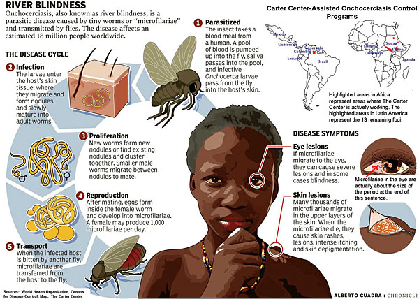 Click on thumbnail image for a chart showing the life cycle of river blindness — from the Carter Center, by Alberto Cuadra
DDT and its descendents were initially effective in controlling the water-dwelling vectors of human diseases. However, the effects of these insecticides on environmental health also had significant, indirect effects on human health. The fish in rivers, which are the main protein source for humans in most developing countries, were drastically reduced by these poisons.
Leave a Comment » | DDT, Geography - Physical, Government, Public health, Rachel Carson | Tagged: Blackfly, DDT, geography, Government, ivermectin, Onchocerciasis, Rachel Carson, River Blindness, Vincent H. Resh | Permalink
Posted by Ed Darrell

Teachers, take a look at this Flash animation about slavery, from the Museum of African Diaspora (MoAD) in San Francisco. Yes, that beautiful, distinctive narrator voice is Maya Angelou — this is a high quality, high-impact presentation.
This MoAD piece, “Slave Narratives,” gives a glimpse of the potential of on-line learning, and what can be done with computers to supercharge a subject. Here slavery is presented as not only a colonial American problem, but is instead carried on through salvery issues in the 21st century. It’s part of the MoAD “Salon,” a site that world geography, world history and U.S. history teachers need to visit right away.
Cyberspace Nova discusses the site in a quick review of recent great Flash animations:
Imagine how it looked like taking a people freedom, torturing them, killing them and moving them far far away from their home. Tears can follow very easily if you just put one picture on your mind how it looked like. Yet, Slave Narrative put thousands of pictures in front of your eyes if you listen to the stories of slaves who lived to write them and share with people that will live after them. Let’s never forget this, because it’s happening today, like some stories from Slave Narratives tell… I love that this site is done in Flash, it is so powerful, it tells a story that we cannot hear a lot… Narrative part not just only justifies use of Flash, whole interactivity makes it great. 5/5

Also look at this photographic exhibit of from MoAD, featuring more than 2,000 photos of people of African descent and places and things important to them — again, with great flash animation.
Bookmark the home page of the museum while you’re there.
1 Comment | Education, Geography - Economic, Geography - Political, History, Human Rights, Museums, On-line education, On-line learning, Slavery | Tagged: Africa, Education, geography, History, Human Rights, Museums, On-line education, On-line learning, Slavery | Permalink
Posted by Ed Darrell
Kenya has cut malaria by nearly half. Without further comment from me, here’s the news story from Gulf Times, Doha, Qatar, and below that, from a few other sources:
Kenya nearly halves child deaths from malaria
Published: Friday, 17 August, 2007, 01:27 AM Doha Time NAIROBI: Kenya announced yesterday that it almost halved malaria deaths among small children by using insecticidal nets (INTs), spurring the World Health Organisation (WHO) to advocate free nets for all as it tackles Africa’s deadliest disease.
Health Minister Charity Ngilu said distribution of 13.4mn INTs over the past five years among children and pregnant women had helped curtail infections, a key success against a disease threatening 40% of the world’s population.
“Childhood deaths have been reduced by 44% in high-risk districts, in-patient malaria cases and deaths are falling (and) there are reduced cases at the community level,” she said in a statement.
“For every 1,000 treated nets used, seven children who might have died of malaria are saved.”
Malaria kills 34,000 children under the age of five each year in Kenya, and threatens the lives of more than 25mn of its population of 34mn people, the ministry said.
Children sleeping under INTs in malaria risk areas are 44% less likely to die than those who are not, according to a survey carried out in four districts representing the country’s epidemiological pattern.
The government has distributed 12mn doses of artemisinin-based therapy (ACT), the latest surefire anti-malaria drug cocktail to replace the mono-therapies that had developed resistance.
In addition, some 824,600 houses in 16 epidemic-prone districts underwent indoor spraying this year.
The government and donors spent 4.7bn shillings ($70.2mn) for the campaign, yet the funds were not enough.Ngilu said the government would freely provide 2mn treated nets annually to ward off mosquitoes at night when they are active, calling on donors to boost the blanket distribution.
“The impact we have seen and the lessons we have learnt through massively distributing INTs, rather than selectively marketing and selling them, will not only benefit Kenya’s children but all Africa’s children,” she said.
In a statement, the WHO said it had abandoned its earlier guideline of targeting only vulnerable groups – under fives and pregnant women – in favour of “making their protection immediate while achieving full coverage”.
“Recent studies have shown that by expanding the use of these nets to all people in targeted areas, increased coverage and enhanced protection can be achieved while protecting all community members.”
WHO chief Margaret Chan said that Kenya’s success “serves as a model that should be replicated throughout ‘malarious’ countries in Africa.”
“This data from Kenya ends the debate about how to deliver the long-lasting nets. No longer should the safety or well-being of your family be based upon whether you are rich or poor,” said WHO’s Global Malaria Programme director Arata Kochi.
Chan and Kochi were deriding the “social marketing” model widely backed by donors of distributing INTs by selling them at subsidised rates, even to vulnerable groups, and raising awareness of their importance.
Although supporting anti-malaria campaigns, public health watchers have chided British and US foreign development agencies for pushing for social marketing in the world’s poorest continent.
The WHO launched a global programme in 1955 to eradicate the disease that has frustrated attempts to create a vaccine owing to its constant mutations.
Using dichloro-diphenyl-trichloroethane (DDT), a powerful insecticide, and the drug chroloquine, the organisation managed to eradicated the disease in the West by the 1960s.
But the programme never got off the ground in the humid and low-lying tropics in sub-Saharan Africa where the disease persisted.
By 1969, the programme collapsed as financing withered in the face of rising poverty, political upheavals and surging opposition to DDT for misuse, not by anti-malaria campaigners, but farmers.
But Kochi said the Stockholm Convention on Persistent Organic Pollutants allowed the use of DDT in endemic countries for “public health only” and Uganda and Malawi were the only African nations keen on the chemical.
Malaria affects more than 1bn people worldwide and kills 1mn – mainly under age five – every year, the vast majority in sub-Saharan Africa. – AFP (Agence France Press) Read the rest of this entry »
6 Comments | Africa, DDT, Economics, Geography - Economic, Geography - Physical, Geography - Political, Malaria, Newspapers, Public health | Tagged: Africa, DDT, Economics, geography, Kenya, Malaria, Newspapers, Public health | Permalink
Posted by Ed Darrell
Aptly named, Salvinia molesta threatens to choke Caddo Lake to death. As Caddo Lake is the only natural lake in Texas, and a site of outstanding beauty and great natural treasure, the friends of Caddo Lake are fighting back.

The New York Times features a lengthy story on the lake and the fight to save it in this week’s Science section (July 31, 2007 – Science is part of the Times every Tuesday).
Every Texas social studies teacher should know Caddo Lake and its stories as well as anything else. It’s the stuff memorable classes are made of.
1. It’s the only “natural” lake in Texas, though it is formed by a dam. The “only honest lake in Texas,” in the local lingo. The original lake was formed by a monumental log jam on the Red River, probably trees blown down by a massive hurricane several hundred years ago.
2. Caddo Lake is named after the Caddo Tribe, the tribe whose word for friend, “tejas,” gave the state its name. (See my earlier post on Caddoland.)
3. Caddo Lake straddles what was once “no man’s land,” or the Neutral Territory, a buffer zone between English/French, then American, and Spanish, then Mexican settlements. It was a haven for criminals, scalawags, filibusterers and revolutionaries. The area plays a large role in the decades of fighting to steal Texas from the Spain, and later from Mexico. Texas history is much better understood when one knows the lake.
4. Caddo Lake once was the means to make Jefferson, Texas, a port city. Until Col. Shreveport dynamited the logjam that made the lake in 1873, Jefferson was a bustling center of commerce. Today Jefferson boasts some wonderfully preserved historic remnants of that era, many converted to bed and breakfast inns, a great weekend getaway. Fishing is good, photography is great.
5. Ladybird Johnson was born nearby, and her family still lives in the area.
6. The Hughes Tool Company had its beginnings on Caddo Lake, where Howard Hughes, Sr., tested his drill bit, “the rock eater,” designed to cut through mud and rock to where the oil was; this is the home of the fortune that Howard Hughes, Jr., inherited, to build to one of the greatest fortunes in the world. That the younger Hughes was a rake, a mechanical genius, an air pioneer, daring movie producer, and weird as hell only makes the story better. Hughes named his movie production company after the lake, Caddo Productions.
6. Contrary to most of Texas’s political leanings, local people around Caddo Lake have rallied to efforts to protect the lake and conserve its rare beauty. The area is designated for protection as a Ramsar Treaty critical wetlands site — a designation that most conservative Texans ridicule and fear (at one point the Texas Republican Party platform opposed conservation easements to protect the lake — bizarre). Latter-day Caddoans welcome the designation, and when we toured the area they sang the praises of Don Henley, the rock and roll musician who is aiding their efforts to save the lake. It’s an odd combination for any political work — uniquely Texas. (Here’s your chance to play the Eagles for your classes, teachers!)
7. When it comes to Texas botany, zoology, and biology in general, Caddo Lake provides the local angle for water quality, water shortages (one proposal is to steal water from the lake for Texas cities far away), wildlife management, and of course, the invasion of exotic species.
8. Everything about this area screams Texas quirkiness. Uncertain, Texas? An often-told story (accurate?) is that when the town applied for a post office, there was a dispute about what to call the town. The fellow who filled out the application wrote “uncertain” in the blank for the town’s name — and that’s how the U.S. Postal Service approved it. Another story holds that the name “Uncertain Landing” caught on because the landing was treacherous mooring for boats. You got a better story about your town’s name? I doubt it.
Save the article from the Times, teachers! You’ll be glad you have it later this year.


6 Comments | 1836, A Good Story, Conservation, Geography - Economic, Geography - Physical, Geography - Political, History, Natural history, Texas, Texas history | Tagged: A Good Story, Caddo Lake, Environmental protection, geography, History, Natural history, Texas, Texas history, Uncertain Texas | Permalink
Posted by Ed Darrell
The merry bands of hoaxsters at “JunkScience.com” and the Competitive Enterprise Institute hope you think DDT is a well-targeted, perfect solution to get rid of malaria. They ignore the devastating effects DDT has on birds, bats and other mammals (including humans), beneficial insects and fish. They don’t care about the difficulties in treating malaria in hospitals, which would continue or grow worse were DDT to be sprayed willy-nilly across the malaria-endemic world.

Plus, CEI is well-funded and has been hammering away on spreading the hoaxes for several years. You may have to dig hard to find the facts, such as the fact that the inventors of DDT as insecticide warned against over-use exactly as did Rachel Carson, (see the Dove Docs archives), or that the death of beneficial insects and beneficial animals can cause disasters, too — or did CEI tell you that DDT can cause your roof to cave in, in Borneo, and that they had to parachute cats in to prevent an epidemic of typhus, caused by DDT?
9 Comments | DDT, Geography - Economic, Hoaxes, Junk science, Lesson plans, Rachel Carson, Science, Voodoo science, War on Science | Tagged: Borneo Cats, DDT, geography, Hoaxes, Junk science, Lesson plans, Rachel Carson, Science | Permalink
Posted by Ed Darrell

Soil erosion in Virginia, photo by W. C. Lowdermilk “Figure 15. — A formerly productive field in Virginia that has been cut to pieces by gully erosion. About 50 million acres of good farm land in the United States have been ruined for further practical cultivation by similar types of erosion.”
From Conquest of the Land through 7,000 Years, by W. C. Lowdermilk, its first director, a soil conservation publication of the U.S. Soil Conservation Service, first issued in about 1939:
When in Palestine in 1939, I pondered the problems of the use of the land through the ages. I wondered if Moses, when he was inspired to deliver the Ten Commandments to the Israelites in the Desert to establish man’s relationship to his Creator and his fellow men — if Moses had foreseen what was to become of the Promised Land after 3,000 years and what was to become of hundreds of millions of acres of once good lands such as I have seen in China, Korea, North Africa, the Near East, and in our own fair land of America — if Moses had foreseen what suicidal agriculture would do to the land of the holy earth — might not have been inspired to deliver another Commandment to establish man’s relation to the earth and to complete man’s trinity of responsibilities to his Creator, to his fellow men, and to the holy earth.
When invited to broadcast a talk on soil conservation in Jerusalem in June 1939, I gave for the first time what has been called an “Eleventh Commandment,” as follows: Thou shalt inherit the Holy Earth as a faithful steward, conserving its resources and productivity from generation to generation. Thou shalt safeguard thy fields from soil erosion, thy living waters from drying up, thy forests from desolation, and protect thy hills from overgrazing by thy herds, that thy descendants may have abundance forever. If any shall fail in this stewardship of the land, thy fruitful fields shall become sterile stony ground and wasting gullies, and thy descendants shall decrease and live in poverty or perish from off the face of the earth.
Leave a Comment » | Conservation, Dust Bowl, Environmental protection, Ethics, Geography - Physical, Geography - Political, History, Natural history, New Deal | Tagged: Conservation, Dust Bowl, Environmental protection, geography, History, New Deal, W. C. Lowdermilk | Permalink
Posted by Ed Darrell
The DVD release of the Texas Chainsaw Massacre’s latest cinema episode is probably driving the traffic to the post I did a while ago noting that the movies are not based on any Texas incidents (see “Based on a true story, except . . .). The original movie, in 1974, was billed as “based on a true story.” “The film which you are about to see is an account of the tragedy which befell a group of five youths, in particular Sally Hardesty and her invalid brother, Franklin,” the Narrator says opening the film.
The latest enfilmations apparently carry the same claim (I say apparently because I have never seen any of them through, and only a few snippets on television of any of them — I go by what I hear and see from others).
We have the testimony of the author of the original screenplay that it is fiction, loosely based on a famous case in Wisconsin which was also, very loosely, the basis for Alfred Hitchcock’s Psycho and the later, more horrifying Silence of the Lambs. Other internet sites say it’s fiction, such as Snopes.com (a favorite and very good hoax and error debunking site).
Still, the kids ask.
Why not turn this into a geography and/or history exercise? Read the rest of this entry »
34 Comments | 100 Milestone Documents of U.S. History, Accuracy, Bogus history, Geography - Physical, History, Lesson plans, Movies, Texas | Tagged: Accuracy, Bogus history, geography, Hewitt Texas, Hoaxes, Lesson plans, Movies, Texas Chainsaw Massacre, Thomas Hewitt | Permalink
Posted by Ed Darrell
August 13, 2006, is the 45th “anniversary” of the erection of the Berlin Wall, the totem of the Cold War that came down in 1989, pushing the end of the Cold War. Residents of Berlin awoke on this day in 1961 to find the communist government of East Germany erecting what would become a 96-mile wall around the “western quarters” of the city — not so much to lay siege to the westerners (that had been tried in 1948, frustrated by the Berlin Airlift) as to keep easterners from “defecting” to the West. The Brandenburg Gate was closed on August 14, and all crossing points were closed on August 26.
From 1961 through 1991 1989, teachers could use the Berlin wall as a simple and clear symbol for the differences between the communist Eastern Bloc, the Soviet Union and her satellite states, and the free West, which included most of the land mass of Germany, England, France, Italy, the United States and other free-market nations — the North Atlantic Treaty Organization (NATO) countries. I suspect most high school kids today know very little about the Wall, why it was there, and what its destruction meant, politically.
This era of history is generally neglected in high school. Many courses fail to go past World War II; in many courses the Cold War is in the curriculum sequenced after the ACT, SAT and state graduation examinations, so students and teachers have tuned out.
But the Wall certain had a sense of drama to it that should make for good lessons. When I visited the wall, in early 1988, late at night, there were eight fresh wreaths honoring eight people who had died trying to cross the Wall in the previous few weeks (in some places it was really a series of walls with space in between to make it easier for the East German guards to shoot people trying to escape) — it’s an image I never forget. Within a year after that, East Germans could travel through Hungary to visit the West, and many “forgot” to return. Within 18 months the wall itself was breached.
The Wall was a great backdrop for speeches, too — President John F. Kennedy visited Berlin in June 1963, and expressed his solidarity with the walled-in people of both West and East Berlin, with the memorable phrase, “Ich bin ein Berliner,“ which produced astounding cheers from the tens of thousands who came to hear him. There are a few German-to-English translators who argue that some of the reaction was due to the fact that “Berliner” is also an idiomatic phrase in Berlin for a bakery confection like a jelly doughnut — so Kennedy’s words were a double entendre that could mean either “I am a citizen of Berlin,” or “I am a jelly doughnut.” [Be sure to see the comments below, from Vince Treacy (9/28/2010).] Ronald Reagan went to the same place Kennedy spoke to the Berlin Wall, too, to the Brandenburg Gate, in his famous June 1987 speech which included a plea to the Soviet Union’s Premier Mikhail Gorbachev: “Mr. Gorbachev, tear down this wall!”

Construction of the Berlin Wall in August 1961 –photo from University of Utah, by Corey Hatch.
Update March 9, 2007: Berlin Airlift information and lesson plans are available from the Truman Library, here, here and here.
Update November 9, 2009: Notes on the 20th anniversary of the fall of the Wall
27 Comments | Cold War, Democracy, Economics, Famous quotes, Free market economics, Freedom - Political, Geography - Political, History | Tagged: Berlin Wall, Cold War, Democracy, Economics, Famous quotes, Free market economics, freedom, geography, History | Permalink
Posted by Ed Darrell
Among many underappreciated mountain peaks in the U.S. is Mount Timpanogos, in the Wasatch Range of the Rockies. It is northeast of Provo, Utah, and it was due east of my bedroom window for the nine years I lived in Pleasant Grove, Utah, before I headed off to college.
Here is a site that offers some stunning views of the mountain: http://utahpictures.com/Timpanogos.html [update: pictures moved to this site: http://utahpictures.com/Timpanogos.php]. While I often hiked the “backside” of the mountain, I never made it all the way to the top. You can see what I missed.
4 Comments | Administrivia, Geography - Physical, Hiking, Utah | Tagged: Administrivia, geography, Hiking, Mt. Timpanogos, photography, Utah | Permalink
Posted by Ed Darrell


Ed Darrell on Texas's Colorado River


Come on in, the water's fine. Come often: Cleanliness is next to godliness.


