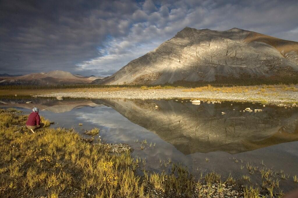
It’s a rising Moon, with the photo taken from the west side of the Lincoln Memorial, perhaps from the Virginia side of the Potomac River. The Lincoln Memorial is now part of the National Park Service’s portfolio of properties around our national capital.
Update:Jude Crook points out in comments (below) that this was a NASA Photo of the Day, originally; two federal agencies cooperating in the interest of photographic excellence . . .
The full moon is seen as it rises near the Lincoln Memorial, Saturday, March 19, 2011, in Washington. The full moon tonight is called a super perigee moon since it is at its closest to Earth in 2011. The last full moon so big and close to Earth occurred in March 1993.
Image Credit: NASA/Bill Ingalls
Spread the word; friends don't allow friends to repeat history.
A long exposure, you can tell by the airplane streaks near the horizon. Walking that fine photography edge of long enough to get the exposure, but short enough not to distort the stars too much.
Long exposure of a Joshua tree, in Joshua Tree National Park. Photo: Sarah Chah (www.sharetheexperience.org)
Viewed from the road, this desert park only hints at its vitality. Closer examination reveals a fascinating variety of plants and animals that make their home in this land shaped by strong winds, unpredictable torrents of rain, and climatic extremes. Dark night skies, a rich cultural history, and surreal geologic features add to the attraction of this place. Come see Joshua Tree National Park for yourself!
But I wonder what brain bending goes on in this image. From Fascinating Pics:
Paris at Sunset, France pic.twitter.com/QnhtkUPKLn Photo by Coolbiere.
What do you think? Painting? Photo? Manipulated photo?
Update: J.A. Higginbotham tracked down the original Flickr photo, by a Coolbiere. Nikon D-800, 70-200 zoom telephoto, at 122mm; claims to have taken it from Mount Parnasse. Luck and preparedness. Wow.
Spread the word; friends don't allow friends to repeat history.
I was born on the Snake River, farther south and west, in Burley, Idaho. It’s a grand river, not so much in the water it moves as the way it moves through the landscape and becomes a part of grander parts of the American west. Kathryn and I honeymooned in Yellowstone, and stayed in Grand Teton on the way out.
There is nothing grander on Earth than a sunrise in the Tetons. Do you think a grizzly appreciates that?
Yeah, gotta get back there.
Spread the word; friends don't allow friends to repeat history.
Columbus feared that King Ferdinand and Queen Isabella would not honor pledges they had made to him as recompense and honor for his great work of discovery on their behalf. Before his final voyage, he assembled a legal document showing those promises made to him, and his work for Spain.
This illustrates, once again, the human dimension of the great drama of the age of exploration, of Columbus’s stumbling on to the America’s in his efforts to get to China.
On January 5, 1502, prior to his fourth and final voyage to America, Columbus gathered several judges and notaries in his home in Seville. The purpose? To have them authorize copies of his archival collection of original documents through which Isabel and Fernando had granted titles, revenues, powers and privileges to Columbus and his descendants. These 36 documents are popularly called “Columbus’ Book of Privileges.” Four copies of his “Book” existed in 1502, three written on vellum and one on paper. The Library’s copy, one of the three on vellum, has a unique paper copy of the Papal Bull Dudum siquidem of September 26, 1493, which extended the Spanish claim for future explorations.
Earth on January 1, 2014. Looks pretty good from this angle.
Can we make it look this good down here on the ground?
NASA caption: Happy New Year! This image shows the Earth today, January 1, 2014, a few hours into the new year, as seen by the Geostationary Operational Environmental Satellites (GOES) satellite. Geostationary describes an orbit in which a satellite is always in the same position with respect to the rotating Earth. This allows GOES to hover continuously over one position on the Earth’s surface, appearing stationary. As a result, GOES provide a constant vigil for the atmospheric “triggers” for severe weather conditions such as tornadoes, flash floods, hail storms, and hurricanes. Image Credit: NASA/NOAA GOES Project #nasa #earth #space #goes #irl #today #happynewyear #planets #solarsystem #newyear #2014 #nye #home
Yosemite Falls is the tallest waterfall in North America, and is a powerful presence in Yosemite Valley. From winter ice to spring flood to autumn dryness, this magnificent waterfall is a dynamic force of nature.
National Park Service photo of Upper Yosemite Falls
U.S. President Theodore Roosevelt (left) and nature preservationist John Muir, founder of the Sierra Club , on Glacier Point in Yosemite National Park in 1903. In the background: Upper and lower Yosemite Falls. (Photo credit: Wikipedia)
73,117
Spread the word; friends don't allow friends to repeat history.
The town of Dinosaur was originally named Artesia; the current name was adopted in 1966, to capitalize on the town’s proximity to Dinosaur National Monument.[6] The monument headquarters is located just east of the town on U.S. Highway 40.
And:
Many streets in the town are named after dinosaurs, including Cletisaurus Circle, Tyrannosaurus Trail, and Antrodemus Alley.[8]
It’s a setup, a straight line waiting for a good comedian.
Brian Tweeted that he wasn’t looking to ridicule, but: “I just imagined thyreophorans, maniraptorans, sauropodomorphs, and their ilk in the congregation.”
That might produce even more comedic situations.
It’s a Southern Baptist Convention-affiliated congregation. Aren’t you curious how Sunday school goes for dinosaur-crazy kids in such a church, in such a town?
Signs of life, signs of the times, signs of something!
Another shot of the directional sign for Dinosaur Baptist Church, from earlier in 2011, I think. From Text of the Day.
From a different angle, one can see that the church is just a couple of blocks off of Stegosaurus Freeway. Wow.
2007 photo of the sign showing street signs at the intersection of 6th Street and Stegosaurus Freeway. Photo by Will Gelnaw, who has copyright to it.
Still, it’s fun to imagine a nice, small town church, with dinosaurs in the back pews singing along. (Instead, Chris Clarke suggested, they are hiding in the Rocks of Ages . . .)
More:
Welcome to Dinosaur, Colorado (Photo credit: J. Stephen Conn)
How much image manipulation, if any, was necessary to capture this enormous-looking Moon rising over a South Dakota “road to nowhere,” close to the 2013 Winter Solstice?
From @GlobePics: “Road To Nowhere – Supermoon” – Supermoon rises over this road to nowhere in eastern South Dakota. pic.twitter.com/82AoFgPvWn
Who should get credit for the photo? (I can’t quite read the name in the lower left corner.)
Photo probably not taken this week: From the US Department of Interior: Happy 53rd birthday to the Arctic National Wildlife Refuge! @USFWSHQ @USFWSRefuges #Alaska pic.twitter.com/2popb7EAvz
Odd that land so severely beautiful, so far out of the way and so difficult to master, has its fate decided in marble halls in Washington, D.C., 3,172 miles distant. The United States is a big, sprawling nation.
Information on the ANWR:
History and Culture
Refuge Establishment: Legislation and Purposes
The Arctic Refuge was established in 1960 and expanded in 1980.
The Arctic Refuge has been providing for the physical and emotional well-being of humans for many thousands of years. It remains an important resource to help sustain local Eskimo and Indian cultures. The Refuge continues to be valued, even by those who never travel within it’s borders, as a symbol of America’s vast and remote wilderness – a place of inspiration and beauty – a promise for the future for all Americans.
Last time the SBOE approved social studies books in 2010, the process was contentious. This photo, from The Christian Science Monitor, shows protests on the books; photo by Larry Kolvoord, Austin American-Statesman
Good news a few days ago was that the Texas State Board of Education approved science books that teach real science, for use in Texas schools.
But the Road Goes On Forever, and the Tea Party Never Ends: Social studies books are up for review, now.
TEA is looking for nominations for reviewers for books in social studies, math and fine arts. Here’s the notice I got in e-mail:
The Texas Education Agency is now accepting nominations to the state review panels that will evaluate instructional materials submitted for adoption under Proclamation 2015.
Proclamation 2015 calls for instructional materials in the following areas:
♦ Social Studies, grades K-12
♦ Social Studies (Spanish), grades K-5
♦ Mathematics, grades 9-12
♦ Fine Arts, grades K-12
State review panels are scheduled to convene in Austin for one week during the summer of 2014 to review materials submitted under Proclamation 2015. The TEA will reserve hotel lodging and reimburse panel members for all travel expenses, as allowable by law.
Panel members should plan to remain on-site for five days to conduct the evaluation.
Panel members will be asked to complete an initial review of instructional materials prior to the in-person review.
Panel members will receive orientation and training both prior to the initial review and at the beginning of the in-person review.
Panel members might be asked to review additional content following the in-person review.
Because many of the samples will be delivered electronically, panel members should be comfortable reviewing materials on-screen rather than in print.
Panel members should also have a working knowledge of Microsoft Excel.
Upon initial contact by a representative of the TEA, state review panel nominees begin a “no-contact” period in which they may not have either direct or indirect contact with any publisher or other person having an interest in the content of instructional materials under evaluation by the panel. The “no contact” period begins with the initial communication from the Texas Education Agency and ends after the State Board of Education (SBOE) adopts the instructional materials. The SBOE is scheduled to adopt Proclamation 2015 materials at its November 2014 meeting.
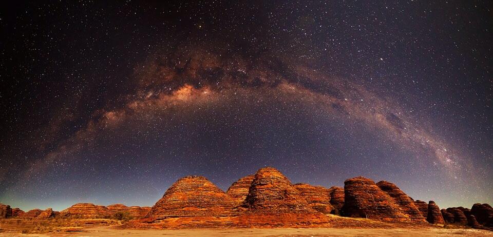
Milky Way Over the Bungle Bungles Image Credit & Copyright: Mike Salway Explanation: Which part of this picture do you find more interesting — the land or the sky? Advocates for the land might cite the beauty of the ancient domes of the Bungle Bungle Range in Western Australia. These picturesque domes appear as huge layered beehives and are made of sandstones and conglomerates deposited over 350 million years ago. Advocates for the sky might laud the beauty of the Milky Way’s central band shown arching from horizon to horizon. The photogenicMilkyWayband formed over 10 billion years ago and now includes many well-known nebulae and bright stars. Fortunately, you don’t have to decide and can enjoy both together in this beautiful 8-frame panorama taken from the dark skies of Purnululu National Park about two months ago.
I’d make some remarks about silly names for land formations in Australia — but here we sit with The Grand Tetons, The Gros Ventre, and several dozen “Molly’s Nipples” in our nation.
It’s a composite of 11 photographs to get the whole panoramic view — which just demonstrates that in photography it’s great to be lucky, but it usually takes great skill to get that amount of luck.
How much processing was involved, really?
Don’t worry, just check out the photo.
Double Moonbow, lava glow and fading Lunar Halo; 11-picture Panoramic taken on the rim of Kilauea’s Caldera On the Last Super Moon. Sean King, Atmospheric Phenomena
An Aussie’s attempt to label the state of the U.S. Don’t laugh — how well can you do labeling a map of Australia? From Texas Hill Country’s Facebook feed, and unknown origin past that.
Found this at the Facebook site of Texas Hill Country. A little rough for high school geography, especially if it’s ninth grade geography (surely you can moderate this a bit, teachers), but a good idea for a quiz?
How well can your students do labeling the U.S.? Will they find this person’s obvious anguish and creative non-answers amusing? Can they do better?
Now turn the tables: How well can your students in the U.S. do labeling a map of Australia? Canada? Mexico?
Ask your students: Is it important to know such stuff? Why?
And you, Dear Reader: What do you think?
Here you go, a map of Australia to practice with:
Unlabeled map of Australia to label! Royalty free produce of Bruce Jones Design, Inc., copyright 2010
Spread the word; friends don't allow friends to repeat history.
Or, until that account is unsuspended by the forces supporting Donald Trump: Follow @FillmoreWhite, the account of the Millard Fillmore White House Library
We've been soaking in the Bathtub for several months, long enough that some of the links we've used have gone to the Great Internet in the Sky.
If you find a dead link, please leave a comment to that post, and tell us what link has expired.
Thanks!
Retired teacher of law, economics, history, AP government, psychology and science. Former speechwriter, press guy and legislative aide in U.S. Senate. Former Department of Education. Former airline real estate, telecom towers, Big 6 (that old!) consultant. Lab and field research in air pollution control.
My blog, Millard Fillmore's Bathtub, is a continuing experiment to test how to use blogs to improve and speed up learning processes for students, perhaps by making some of the courses actually interesting. It is a blog for teachers, to see if we can use blogs. It is for people interested in social studies and social studies education, to see if we can learn to get it right. It's a blog for science fans, to promote good science and good science policy. It's a blog for people interested in good government and how to achieve it.
BS in Mass Communication, University of Utah
Graduate study in Rhetoric and Speech Communication, University of Arizona
JD from the National Law Center, George Washington University


 Posted by Ed Darrell


 and n...")


