A great photo from Pete Souza, the current White House photographer. I’m hoping to track down I’ve tracked down even more details on this, because not all sources like to post all the credit information or other stuff a newspaper or blog should have . . .
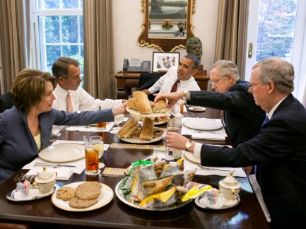
Photo of a lunch in an anteroom of the President’s office, with President Obama, House Speaker John Boehner, House Minority Leader Nancy Pelosi, Senate Majority Leader Harry Reid, and Senate Minority Leader Mitch McConnell.
Consolidated News published the photo for its clients with this information:
United States President Barack Obama has lunch with members of the Congressional Leadership in the Oval Office Private Dining Room, May 16, 2012. The President served hoagies from Taylor Gourmet, which he purchased after a small business roundtable earlier in the day. Seated, clockwise from the President, are: U.S. Senate Majority Leader Harry Reid (Democrat of Nevada), U.S. Senate Republican Leader Mitch McConnell (Republican of Kentucky), U.S. House Minority Leader Nancy Pelosi (Democrat of California), and U.S. House Speaker John Boehner (Republican of Ohio)..Mandatory Credit: Pete Souza – White House via CNP
At least we know where to get sandwiches like that, now. (Here’s the photo in the White House Flickr set.)

Senate Majority Leader Mike Mansfield; oil on canvas by Aaron Shikler, 1978; photo of painting from Wikipedia
Way back in the Early Holocene, when I first interned with the U.S. Senate, Majority Leader Mike Mansfield, D-Montana, held a close friendship with Sen. George Aiken, R-Vermont. Many mornings they breakfasted together in the staff carry-out in the basement of the Capitol; their wives were friends, too. One morning we got a question on some hot political issue at the Democratic Policy Committee (where I shared the best office I ever had in the third floor of the Capitol); I was dispatched to find Mansfield at breakfast and get an answer. I found him dining with Aiken.
I forget the issue, but it was highly politically charged, something about policy on Vietnam. Republicans and Democrats were much at war on the issue. Mansfield read the note, and showed it to Aiken. They discussed the issue while Mansfield penned an answer and handed it to me. No big deal — two senators dealing with an important issue, talking it over.
When I joined Senate staff in a permanent position, life was much different among the senators. The easy camradery between Mansfield and Aiken couldn’t be found anywhere. That was in the late 1970s. Partisanship was much sharper and nastier than I had seen earlier. Vietnam was over, and that was probably a good thing. The divisiveness I found would not have lent itself to any resolution of Vietnam.
At the RARE II conference at the University of Montana, in 1978, I heard a presentation from a staffer to Montana’s Sen. Paul Hatfield, if I recall correctly, a guy who had staffed for Sen. Lee Metcalf before. He described the difficulties in getting serious legislation done on public lands issues. As he described it, especially before the installation of air conditioning in the Capitol, the Senate would recess for the insufferable summer heat. Senators, who had developed working relationships, if not friendships, would visit each other in their home states, for hunting and sight-seeing, among other things. A Montana senator might show his colleague from Vermont how different the Rocky Mountains are from the Appalachians. A Louisana senator might show his colleagues from western states how different is flood control on the Mississippi than on the Colorado or Sacramento, or Columbia. By the time the Senate got back to business in the fall, legislation had been worked out, key alliances formed to get things done for various states, and though opposition was expressed to many projects, it was genuine difference of opinion expressed to friends.
That’s gone. In 2013, it’s rare a Member of Congress can develop those kinds of relationships with other Members, especially with the fund-raising requirements for re-election. Members travel back to their states and districts as many weekends as they can; they get to know their staff on each end, but they don’t know the other senators, or members of Congress.
President Warren G. Harding doesn’t have a reputation as a great president; but his poker parties were famous. Lyndon Johnson didn’t play poker a lot (though I understand he did on occasion), but his presidency’s record in photographs show that he invited Members of Congress individually for afternoon meetings, often punctuated with a drink, always slathered in business and the potential for favors or arm-twisting. Those sessions are legendary for the legislation they greased into law.
When I saw that photo at the top, I was put in mind of another famous image.
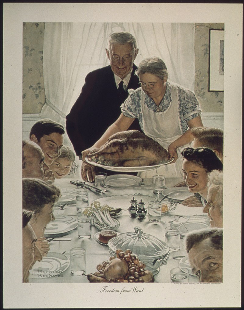
Norman Rockwell’s painting, “Freedom from Want,” part of a quartet based on the Four Freedoms State of the Union Speech of Franklin Roosevelt, in January 1941.
Did Souza have that Rockwell painting in mind when he framed that shot?
Rockwell’s work was more than just iconic, really. In the simple history, from Wikipedia:
The Four Freedoms or Four Essential Human Freedoms is a series of oil paintings produced in 1943 by the American artist Norman Rockwell. The paintings are approximately equal in dimension with measurements of 45.75 inches (116.2 cm) × 35.5 inches (90 cm).[1] The series, now in the Norman Rockwell Museum, was made for reproduction in The Saturday Evening Post over the course of four consecutive weeks in 1943 alongside essays by prominent thinkers of the day. Later they were the highlight of a touring exhibition sponsored by the Saturday Evening Post and the United States Department of the Treasury. The touring exhibition and accompanying sales drives raised over US$132 million in the sale of war bonds.[2]
The Four Freedoms theme was derived from the 1941 State of the Union Address by United States President Franklin Roosevelt delivered to the 77th United States Congress on January 6, 1941.[3] During the speech he identified four essential human rights (Freedom of Speech, Freedom of Worship, Freedom From Want and Freedom From Fear) that should be universally protected and should serve as a reminder of the American motivation for fighting in World War II.[4]
The theme was incorporated into the Atlantic Charter,[5] and it became part of the charter of the United Nations.[6] Roosevelt’s message was as follows: “In the future days which we seek to make secure, we look forward to a world founded upon four essential human freedoms.”[3][7]
Torpedo sandwiches from Taylor’s don’t exactly make a Thanksgiving dinner, but that’s not the point. Rockwell portrayed an American family — at Thanksgiving, perhaps — sitting down to enjoy dinner together, breaking bread together as a Christian preacher might put it in a sermon. President Johnson famously invited, “Come, let us reason together.” Around Obama’s smaller-than-Rockwell’s table, the smiles are not so evident. But I still see hope.
I see some hope for friendship, for the relationships that might move legislation, for the legislation that might move the nation. God and Norman Rockwell know we could use it.
We can hope, can’t we?
More, perhaps related:
Spread the word; friends don't allow friends to repeat history.


 Posted by Ed Darrell


")


