It’s been 57 years since the youngest state entered the union — the longest stretch in which the U.S. has not added another state.
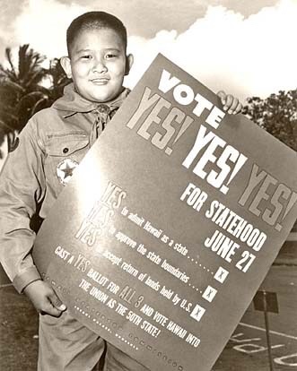
“On June 14, 1959, Boy Scout Milton Motooka helped get the word out for Hawaii’s statehood plebiscite to be held 13 days later. A new documentary will focus on Hawaii’s statehood.” Hawaiians voted yes in the plebiscite, and statehood was declared two months later. (Whatever became of Scout Motooka? See comments on last year’s post.)
“On June 14, 1959, Boy Scout Milton Motooka helped get the word out for Hawaii’s statehood plebiscite to be held 13 days later. A new documentary will focus on Hawaii’s statehood.” Hawaiians voted yes in the plebiscite, and statehood was declared two months later. (Whatever became of Scout Motooka?)
June’s plebiscite smoothed the path for statehood, declared two months later.
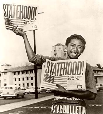
13-year-old paperboy Chester Kahapea happily hawks a commemorative edition of the Honolulu Star-Bulletin with the headline showing the state had achieved statehood after the U.S. House of Representatives passed the law authorizing Hawaii as a state. Star-Bulletin photo by Murray Befeler.
Hawaii formally celebrates the day on the third Friday in August, this year on the 19th. I hope you joined in the festivities (it’s a holiday in Hawaii) — but under the U.S. Flag Code, you may certainly fly your flags on August 21, regardless which day of the week that is.
Specimen copy of the ballot used by Hawaiians in a June 27, 1959, plebiscite to approve conditions of statehood. Image from Hawaii Magazine, 2009
After the U.S. annexed Hawaii in 1898 (in action separate from the Spanish-American War) attempts at getting Hawaii admitted as a state got rolling. After World War II, with the strategic importance of the islands firmly implanted in Americans’ minds, the project picked up some steam. Still, it was 14 years after the end of the war that agreements were worked out between the people of Hawaii, the Hawaiian royal family, Congress and the executive branch. The deal passed into law had to be ratified by a plebiscite among Hawaiian citizens. The proposition won approval with 94% of votes in favor.
Other than the tiny handful of loudmouth birthers, most Americans today are happy to have Hawaii as a state, the fifth richest in the U.S. by personal income. The nation has a lot of good and great beaches, but the idea of catching sun and surf in Hawaii on vacation might be considered an idealized part of the American dream.
“Loudmouth birthers?” Yeah, Barack Obama, our 45th President, was born in Hawaii in 1961. Some whiners think that, but for statehood, Obama would not have been a citizen eligible to be president. Hawaii is not good ground for growing sour grapes, though. Birth in a territory would probably be enough to make him eligible. Water under the bridge: Hawaii was a state in 1961. President Obama remains president.
U.S. postage stamp issued in 2009 commemorating the 50th anniversary of Hawaii’s admission to the union.
Contrast the first class postage price above with the airmail postage price of this stamp issued in 1959 — August 21, 1959 7¢ Rose Hawaii Statehood stamp. Wikipedia image
Trinity was conducted in secret as party of the Manhattan Project. Though thousands of people were involved in the creation of the weapon, only a relative handful knew the scope of the project and the ultimate goal. Probably fewer than 200 people were actually involved in the test knowing what it was. Manhattan Project created two secret cities, at Oak Ridge, Tennessee, and Los Alamos, New Mexico. Workers and their families probably did not know when the event occurred.
It’s astonishing to think anyone could hide the explosion today. Near the end of World War II, after Germany had surrendered to end the war in Europe, no one really knew just what at atomic explosion would look or sound like. The test occurred near dawn in a very desolate part of New Mexico’s southern desert, a then sparsely populated state. A few thousand may have seen the flash; a few hundred may have heard or felt the explosion. No one in government confirmed any report of a weapon.
President Harry Truman got news of the successful test while working out the end of the War in the Pacific as well as Europe mop-up operations, at the Potsdam Conference with Winston Churchill and Joseph Stalin. The decision to use the weapon came within a few days, and Hiroshima was attacked with an atomic weapon on August 6, followed by an attack on Nagasaki on August 9. Japan’s unconditional surrender following those attacks stopped plans for an invasion of Japan’s main islands which most likely would have caused millions of military casualties and millions of civilian casualties.
Rare color photograph of the first nuclear test at Trinity site, July 16, 1945. Blurriness is in the original photograph (done when color photography was still fairly new). (Photo credit: Wikipedia)
Trinity was proof of concept test of Fat Man implosion nuclear bomb design. Would it work & how well? pic.twitter.com/ApUHOGtBnx
— Martin “Doomsday” Pfeiffer 🏳️🌈 (@NuclearAnthro) July 16, 2016
This is based on an earlier post, and is mostly an encore post.
Spread the word; friends don't allow friends to repeat history.
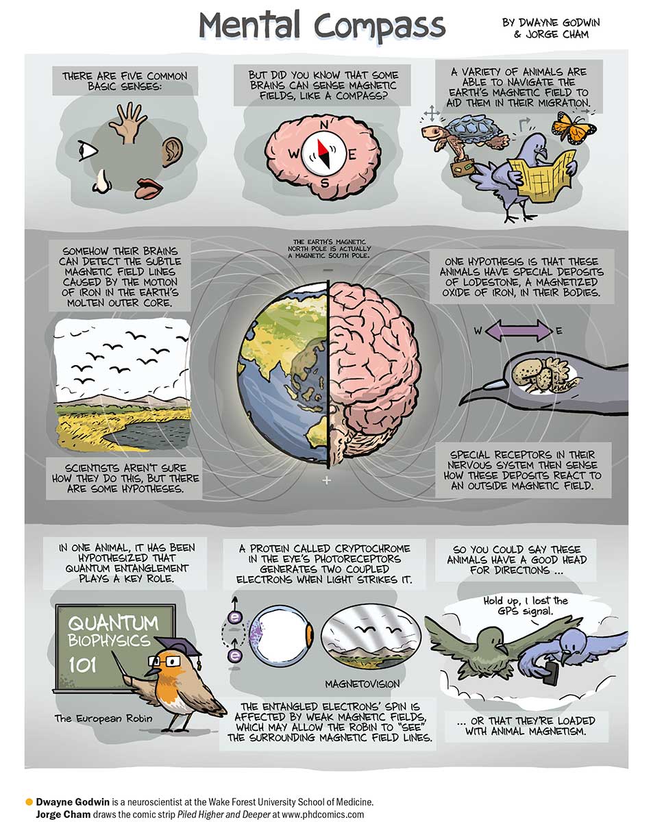
Another great find on Twitter, for geography, biology and physics classes.
How do birds navigate, compared to, say, Columbus? Most U.S. history texts make a big deal of Columbus’s navigation, made possible by invention of the magnetic compass and the sextant.
Birds are more accurate, and they have neither. Well, they don’t have external magnetic compasses. See the cartoon.
Neuroscientist and cartoonist team up to talk about birds “seeing” magnetic lines of the Earth! Information from Dwayne Godwin at Wake Forest University School of Medicine, with drawings by Jorge Cham, who draws Piled Higher and Deeper.
Teachers, have someone in the drafting department make this cartoon into a poster for your classroom.
As usual, the truth is more weird and wonderful than fiction writers could hope to invent.
From top to bottom, it looks like a sunrise on the mountain. But Timpanogos faces west; the sun rises from behind this face. Two possible explanations. The more mundane explanation would be that the series starts with the bottom photo, progressing to the top. Shadows support that explanation.
The slightly more colorful explanation would be, as we often see here in Texas, weather moving from west to east; and in the late afternoon a cover of clouds moves far enough east that the setting sun finally is uncovered, peeking out from underneath the clouds to light the land with that wonderful golden hour sun for a few minutes, before setting.
Timpanogos, like the rock it is, sits majestically either way.
Tweet from sofiaaugustineadams (@sofiaaadams): Mountain time #timelapse #timpanogos
I Tweeted Ms. Adams (I’m presuming her name to be Sofia Augustine Adams) to ask which it is. For those who love Timpanogos, it won’t matter much.
My guess is the photo was taken from south of Orem, Utah, probably near Interstate Highway 15 which transects Utah County.
Update: Ms. Adams informs us (see comments) it is a setting sun, with the bottom photo being the first in the series. Thank you!
Spread the word; friends don't allow friends to repeat history.
Wisdom is a 64-year old albatross who remarkably returns to the Midway National Wildlife Refuge every year, and has raised chicks most of those years. Midway NWR is northwest of Hawaii:
“Conservatives” want to sell these lands off, or drill for oil or gas, or mine for minerals, on many of these lands. Will these places be preserved for your great grandchildren and America’s future?
Spread the word; friends don't allow friends to repeat history.
Columbus feared that King Ferdinand and Queen Isabella would not honor pledges they had made to him as recompense and honor for his great work of discovery on their behalf. Before his final voyage, he assembled a legal document showing those promises made to him, and his work for Spain.
This illustrates, once again, the human dimension of the great drama of the age of exploration, of Columbus’s stumbling on to the America’s in his efforts to get to China.
On January 5, 1502, prior to his fourth and final voyage to America, Columbus gathered several judges and notaries in his home in Seville. The purpose? To have them authorize copies of his archival collection of original documents through which Isabel and Fernando had granted titles, revenues, powers and privileges to Columbus and his descendants. These 36 documents are popularly called “Columbus’ Book of Privileges.” Four copies of his “Book” existed in 1502, three written on vellum and one on paper. The Library’s copy, one of the three on vellum, has a unique paper copy of the Papal Bull Dudum siquidem of September 26, 1493, which extended the Spanish claim for future explorations.
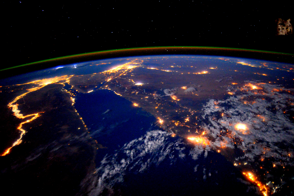
Geography teachers love the Nile Delta because it so well epitomizes what a river delta is — clear demonstration of the delta form, in real photos.
From the International Space Station, the model gets ramped up a bit:
Twitter caption: A stunning pic taken by @StationCDRKelly while on @Space_Station shows the Nile River at night http://go.nasa.gov/1iAE3EV
The Nile becomes a river of light, showing the advance of electrified human settlement along the banks, and providing stark contrast to the unlighted desert on either side of the river.
What other cities, landmarks, or geographical features can you identify in the photo?
Spread the word; friends don't allow friends to repeat history.
I was sad to discover most of my U.S. history students (juniors) didn’t know what an equinox is. So the autumnal equinox always offers a teaching moment that ticks off the teacher raters.
This is what an equinox looks like, from 2013 photos.
From Astronomy Picture of the Day: Earth at Equinox. From the Russian meteorological satellite Elektro-L
Explanation from NASA:
Equinox Earth Image Credit: Roscosmos / NTSOMZ / zelenyikot.livejournal.com
Courtesy: Igor Tirsky, Vitaliy Egorov Explanation: From a geostationary orbit 36,000 kilometers above the equator, Russian meteorological satellite Elektro-L takes high-resolution images our fair planet every 30 minutes. But only twice a year, during an Equinox, can it capture an image like this one, showing an entire hemisphere bathed in sunlight. At an Equinox, the Earth’s axis of rotation is not tilted toward or away from the Sun, so the solar illumination can extend to both the planet’s poles. Of course, this Elektro-L picture was recorded on September 22nd [2013], at the northern hemisphere’s autumnal equinox. For a moment on that date, the Sun was behind the geostationary satellite and a telltale glint of reflected sunlight is seen crossing the equator, at the location on the planet with satellite and sun directly overhead (5MB animated gif).
Wait. Animated .gif? Cool!
The Earth at equinox, 2013; from Russan space program, via NASA.
You do discuss equinoxes in your social studies classes, right? A good time to break out the globes and flashlights, and let the students discover how it works.
The autumnal equinox is at 8:22 GMT or 4:22 am EDT on Wednesday. The two satellite images below from the European Meteosat show the sun angle on Earth from June 22 near the summer solstice and then today at the same time. Notice the sun angle has changed dramatically, and the High Arctic is no longer seeing 24 hour daylight.
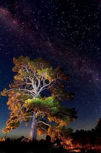
Milky Way over Bosque Alegre Station in Argentina Image Credit & Copyright: Sebastián D’ Alessandro. To see the picture in its unadorned glory without the explanatory overlay, click on the image to get to NASA’s APOD site.
Stars in the Southern Hemisphere differ a lot from what we see in the North, most famously with the Southern Cross (Crux, in the image above).
Glorious anyway; more glory to go around.
If you click over to the APOD site, you can also see this photo without the overlay, which is another whole world of wonderfulness.
Explanation: What are those streaks of light in the sky? First and foremost, the arching structure is the central band of our Milky Way galaxy. Visible in this galactic band are millions of distant stars mixed with numerous lanes of dark dust. Harder to discern is a nearly vertical beam of light rising from the horizon, just to the right of the image center. This beam is zodiacal light, sunlight scattered by dust in our Solar System that may be surprisingly prominent just after sunset or just before sunrise. In the foreground are several telescopes of the Bosque Alegre Astrophysical Station of the National University of Cordoba in Argentina. The station schedules weekend tours and conducts research into the nature of many astronomical objects including comets, active galaxies, and clusters of galaxies. The featured image was taken early this month.
Spread the word; friends don't allow friends to repeat history.
Svein T veitdal is one of those rare scientists who can explain why science observations are important in effects on people in just living their lives. A good man to listen to (you can follow his Twitter account: @tveitdal).
Critics of the science of climate change and the work to slow or halt warming don’t like charts like that. Sea level is something measured by humans, worldwide, for a long time. That’s real data.
And it’s scary.
T veitdal’s Tweet was just a small part of a very large graphic from NASA, explaining the observations that tell us sea levels rise, how the observations are made, and what it means to you and me.
NASA infographic on sea level rise: We know seas are rising and we know why. The urgent questions are by how much and how quickly. Available to download, this infographic covers the science behind sea level rise, who’s affected, how much melting ice is contributing, and what NASA is doing to help.
Yeah. “Your planet is changing. We’re on it.”
As Ban-ki Moon said the other day, there is no Planet B. We have only one Earth.
General science teachers, geology teachers, physics and chemistry teachers, history, geography and human geography teachers should see if someone at your school has a plotter and can print this thing out for you, poster size.
Spread the word; friends don't allow friends to repeat history.
Much as the GOP Caucus and other climate-change deniers, Roman officials in Pompeii and Herculaneum refused to be alarmed at the ground shaking, and obvious eruptions from Mount Vesuvius, on August 24, 79 C.E.
At noon on August 24, 79 AD, Mount Vesuvius erupted and buried the cities of Pompeii and Herculaneum. pic.twitter.com/ooYjzpDfS8
It’s been 56 years since the youngest state entered the union — the longest stretch in which the U.S. has not added another state.
“On June 14, 1959, Boy Scout Milton Motooka helped get the word out for Hawaii’s statehood plebiscite to be held 13 days later. A new documentary will focus on Hawaii’s statehood.” Hawaiians voted yes in the plebiscite, and statehood was declared two months later. (Whatever became of Scout Motooka?)
“On June 14, 1959, Boy Scout Milton Motooka helped get the word out for Hawaii’s statehood plebiscite to be held 13 days later. A new documentary will focus on Hawaii’s statehood.” Hawaiians voted yes in the plebiscite, and statehood was declared two months later. (Whatever became of Scout Motooka?)
June’s plebiscite smoothed the path for statehood, declared two months later.
13-year-old paperboy Chester Kahapea happily hawks a commemorative edition of the Honolulu Star-Bulletin with the headline showing the state had achieved statehood after the U.S. House of Representatives passed the law authorizing Hawaii as a state. Star-Bulletin photo by Murray Befeler.
Hawaii formally celebrates the day on the third Friday in August, this year coincidentally on the 21st. I hope you joined in the festivities (it’s a holiday in Hawaii) — but under the U.S. Flag Code, you may certainly fly your flags on August 21, regardless which day of the week that is.
Specimen copy of the ballot used by Hawaiians in a June 27, 1959, plebiscite to approve conditions of statehood. Image from Hawaii Magazine, 2009
After the U.S. annexed Hawaii in 1898 (in action separate from the Spanish-American War) attempts at getting Hawaii admitted as a state got rolling. After World War II, with the strategic importance of the islands firmly implanted in Americans’ minds, the project picked up some steam. Still, it was 14 years after the end of the war that agreements were worked out between the people of Hawaii, the Hawaiian royal family, Congress and the executive branch. The deal passed into law had to be ratified by a plebiscite among Hawaiian citizens. The proposition won approval with 94% of votes in favor.
Other than the tiny handful of loudmouth birthers, most Americans today are happy to have Hawaii as a state, the fifth richest in the U.S. by personal income. The nation has a lot of good and great beaches, but the idea of catching sun and surf in Hawaii on vacation might be considered an idealized part of the American dream.
From Prologue, the blog of the National Archives: This petition, rolled onto a wooden spool, was signed by 116,000 supporters of Hawaii statehood and presented to the U.S. Senate on February 26, 1954. (RG 46, Records of the U.S. Senate)
U.S. postage stamp issued in 2009 commemorating the 50th anniversary of Hawaii’s admission to the union.
Contrast the first class postage price above with the airmail postage price of this stamp issued in 1959 — August 21, 1959 7¢ Rose Hawaii Statehood stamp. Wikipedia image
National Geographic Society reminded us they’ve had to change maps of the arctic.
National Geographic Society composed this GIF to compare their maps over past 16 years: A GIF of National Geographic atlases from 1999 through 2014 shows how Arctic ice has melted over time.
Ice loss is accelerated in the Arctic because of a phenomenon known as the feedback loop: Thin ice is less reflective than thick ice, allowing more sunlight to be absorbed by the ocean, which in turn weakens the ice and warms the ocean even more, NASA says.
“You hear reports all the time in the media about this,” Valdés said. “Until you have a hard-copy map in your hand, the message doesn’t really hit home.”
At the last edition of the National Geographic Atlas, a video described why and how changes were made.
We used to think the old Earth was so massive, little could humans do to change it. While it’s probably still true the rock will survive after humans are extinct, we now know we can foul our nest enough to make it uncomfortable, or impossible for our species to stay here.
Global warming is changing the planet. Maps must be changed to show the new face.
Have we acted soon enough, and hard enough to save space for humans to live?
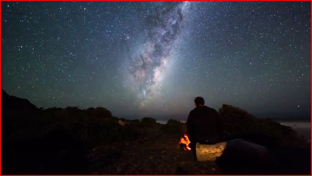
1440 individual photographs captured over 13 hours cut together into one incredible time-lapse video.
Photographer and videographer Mark Gee shot this breath-taking footage of the southern skies around his hometown of Wellington, New Zealand. The stunning one-minute clip is a collection of Mark’s most memorable night sky moments over the past year.
The majority of the video was shot on Wellington’s South Coast (watch out for air traffic) while the campfire and the camping scenes were filmed in Cape Palliser and the Tararua Ranges.
From Gee’s Youtube site, the longer film (1 minute!):
Spread the word; friends don't allow friends to repeat history.
Or, until that account is unsuspended by the forces supporting Donald Trump: Follow @FillmoreWhite, the account of the Millard Fillmore White House Library
We've been soaking in the Bathtub for several months, long enough that some of the links we've used have gone to the Great Internet in the Sky.
If you find a dead link, please leave a comment to that post, and tell us what link has expired.
Thanks!
Retired teacher of law, economics, history, AP government, psychology and science. Former speechwriter, press guy and legislative aide in U.S. Senate. Former Department of Education. Former airline real estate, telecom towers, Big 6 (that old!) consultant. Lab and field research in air pollution control.
My blog, Millard Fillmore's Bathtub, is a continuing experiment to test how to use blogs to improve and speed up learning processes for students, perhaps by making some of the courses actually interesting. It is a blog for teachers, to see if we can use blogs. It is for people interested in social studies and social studies education, to see if we can learn to get it right. It's a blog for science fans, to promote good science and good science policy. It's a blog for people interested in good government and how to achieve it.
BS in Mass Communication, University of Utah
Graduate study in Rhetoric and Speech Communication, University of Arizona
JD from the National Law Center, George Washington University


 Posted by Ed Darrell


