July 19, 2009
World Treasures of the Library of Congress looks like a good source of images and information for world history classes and student projects.
. Library of Congress")
Magna charta cum statutis angliae, (Great Charter with English Statutes). Library of Congress
These links are to exhibits that are closed, but whose images are still maintained on line. The Library promises to update exhibits, and on line collections will grow, too.
There really is some remarkable stuff, most of it obscure enough to be really cool, still.
.")
A 16th century miniature pictures Rustam, the hero of the Persian national epic, The Shah Namah, tossed into the sea by the demon Akwan. (Library of Congress, Near East Section).
Spread the word; friends don't allow friends to repeat history.
 Leave a Comment » |
  Art, Historic documents, History, History images, History museums, Images, World history | Tagged: Art, Classroom Resources, History images, Library of Congress, World history |
  Permalink
 Posted by Ed Darrell
May 23, 2009
In a drawer in a file box in the U.S. Patent Office in Washington, D.C., is a study in black ink on white paper, lines that resemble those images most of us have of the first Wright Bros. flyer, usually dubbed “Kittyhawk” after the place it first took to the air.

Drawing 1 from patent granted to Orville Wright for a flying machine
The patent was issued on May 22, 1906, to Orville Wright, Patent No. 821393, for a “flying machine.”
It makes more sense if you turn the drawing on its side.

Wright Bros. flying machine, from patent drawing
Why did it take three years to get the patent issued?
Below the fold, the rest of the patent.
Read the rest of this entry »
Spread the word; friends don't allow friends to repeat history.
1 Comment | Airplanes, DBQ sources, Historic documents, History, History images, Images, Invention, Patents, Science, Technology | Tagged: Airplane, Aviation, Flying, Historic documents, History, History images, May 22 1906, Patents, Science, Technology, Wright Brothers | Permalink
Posted by Ed Darrell
May 20, 2009

Greece and the Aegean Sea, mosaic image from European Space Agency's MERIS Satellite
Great collection of photos from the European Space Agency (ESA), from their Earth from Space: Image of the Week series. This one is a mosaic of Greece, the Balkans and the Aegean Sea.
Surely this could be made into a bell ringer/warmup. Check out the images for other geographic forms, and great photos of them. Nose around the ESA site, there are some great finds. Can you quickly identify this image, for example (without looking at the name of the photo file)?
Spread the word; friends don't allow friends to repeat history.
1 Comment | Bell Ringers, Education, Geography - Physical, Images, Maps, Space exploration, Teaching, Warm-up exercises | Permalink
Posted by Ed Darrell
April 20, 2009
About 75,000 images, most very high quality, for classroom use. Images are sorted into categories that should align with all state standards and any textbook series — at the California State Universities, World Images Kiosk. There are a lot of images from ancient cultures, a lot of images from pre-Renaissance times, and a rich panorama of other images.
For example, Jasper Johns’ 1961 pop art map of the United States . . .

JOHNS Jasper | Map. | 1961 | American | Pop Art | | North America. | | ©Jasper Johns ; Kathleen Cohen
Spread the word; friends don't allow friends to repeat history.
6 Comments | Art, History and art, History images, Images, Maps | Tagged: California State Universities, Classroom Materials, geography, History, Images, Social Studies, World Images Kiosk | Permalink
Posted by Ed Darrell
March 18, 2009

From the National Guard Image Gallery: Fort Wagner, South Carolina, July 18, 1863; "The Old Flag Never Touched the Ground": The 54th Massachusetts Volunteer Infantry Regiment was recruited in the spring of 1863 by Governor John Andrew, who had secured the reluctant permission of the War Department to create a regiment of African-American soldiers. Like all Massachusetts Civil War soldiers, the 54th's men were enlisted in the Massachusetts Volunteer Militia. These Guardsmen would serve as a test case for many skeptical whites who believed that blacks could not be good soldiers. The battle that proved they could was fought on Morris Island, at the mouth of Charleston Harbor. Following three days of skirmishes and forced marches with little rest, and 24 hours with no food, the regimental commander, Colonel Robert Gould Shaw, requested the perilous honor of leading the attack of Fort Wagner, a sand and palmetto log bastion. As night fell, 600 men of the 54th advanced with bayonets fixed. Despite withering cannon and rifle fire, the men sustained their charge until they reached the top of the rampart. There, Colonel Shaw was mortally wounded. There, also, Sergeant William Carney, who had earlier taken up the National Colors when the color sergeant had been shot, planted the flag and fought off numerous attempts by the Confederates to capture it. Without support, and faced with superior numbers and firepower, the 54th was forced to pull back. Despite two severe wounds, Sergeant Carney carried the colors to the rear. When praised for his bravery, he modestly replied, "I only did my duty; the old flag never touched the ground." Carney was awarded the Medal of Honor for his actions, the first African-American to receive the award. The 54th Massachusetts suffered 270 casualties in the failed assault, but the greater message was not lost: some 180,000 African-American soldiers followed in the footsteps of these gallant Guardsmen, and proved that African-American soldiers could, indeed, fight heroically if given the opportunity.
This is one of a series of artworks describing the history of the National Guard. A sizable gallery of art covers the first muster of a militia in Salem, Massachusetts, in 1637, through rescue and recovery efforts after Hurricane Katrina in 2005. Along the way are highlights such as Lexington and Concord, Teddy Roosevelt’s New Mexico Rough Riders in Cuba, including Fort Wagner and the return of General Lafayette. With some caution on accuracy, these are good for classroom use (the Rough Riders picture shows a man on horseback, but I understand the Rough Riders’ horses had not yet arrived when they stormed up San Juan Hill; it took more than 30 years for Carney to get his medal, etc.).
Spread the word; friends don't allow friends to repeat history.
Leave a Comment » | Heroes, History, History images, Images, Medal of Honor, Military History, War | Tagged: Heroes, History, History images, Medal of Honor, National Guard, War, William Carney | Permalink
Posted by Ed Darrell
February 3, 2009
Can’t embed the photo here. Panoramic photos are cool things to use to capture history. Photographer David Bergman made a colossal, 1,464 megapixel photo of the inauguration of Barack Obama — you gotta see it.
Bergman described it:
I made a panoramic image showing the nearly two million people who watched President Obama’s inaugural address. To do so, I clamped a Gigapan Imager to the railing on the north media platform about six feet from my photo position. The Gigapan is a robotic camera mount that allows me to take multiple images and stitch them together, creating a massive image file.
My final photo is made up of 220 Canon G10 images and the file is 59,783 X 24,658 pixels or 1,474 megapixels. It took more than six and a half hours for the Gigapan software to put together all of the images on my Macbook Pro and the completed TIF file is almost 2 gigabytes.
Bergman is offering prints for sale.
Were you at the inauguration, on the Capitol grounds? Check Bergman’s photo, and zoom in to see whether you can see yourself in history.

A smaller version of Bergman’s GigaPan photo of the inauguration of Barack Obama; go see the zoomable version at Bergman’s site, and marvel at the detail of faces
Tip of the old scrub brush to julie@century.
Spread the word; friends don't allow friends to repeat history.
3 Comments | Barack Obama, History, History images, Images, President Obama, Presidents, Technology | Tagged: David Bergman, GigaPan, History, Images, Obama's Inauguration, Panoramic Photo, Technology, U.S. Capitol | Permalink
Posted by Ed Darrell
January 4, 2009
Go look at Barry Weber’s post at First Morning.
Spend at least a full minute looking at that photograph.
Wow!
Look at every single face. Each face is the verse of an epic poem. Each expression is a note in a symphony. Here are a hundred eyes full of excitement and joy, and..(though these kids don’t know it yet their parents and grandparents do)..hope. This is the kind of Hope that straightens paths, brightens colors, and builds bridges to possibilities. It is the kind of Hope that I feel so grateful to have been able to witness, and even feel in my own heart.
But, just look at these kids! Whatever I might feel is peanuts compared to the smiles, laughter, and amazement of these young ones.
By many accountings, these are dark days for the United States. Those faces show the light of the future — they may be the light of the future.
Nice catch, Mr. Weber.
Spread the word; friends don't allow friends to repeat history.
1 Comment | Barack Obama, Capturing history, Citizenship, Heroes, History, Images, Leadership, Obama 2008, President Obama, Presidents | Tagged: Barack Obama, Citizenship, Education, Heroes, History, hope | Permalink
Posted by Ed Darrell
December 17, 2008
In English, it’s just one letter difference between “winds” and “wings.” An encore post, commemorating one historic event from December 17 involving both winds and wings:

Photo from Treasures of the Library of Congress; “First Flight” by John T. Daniels (d. 1948); this is a modern gelatin print from the glass negative.
Ten feet in altitude, 120 feet traveled, 12 seconds long. That was the first flight in a heavier-than-air machine achieved by Orville and Wilbur Wright of Dayton, Ohio, at Kittyhawk, North Carolina, on December 17, 1903.
From the Library of Congress:
On the morning of December 17, 1903, Wilbur and Orville Wright took turns piloting and monitoring their flying machine in Kill Devil Hills, North Carolina. Orville piloted the first flight that lasted just twelve seconds. On the fourth and final flight of the day, Wilbur traveled 852 feet, remaining airborne for 57 seconds. That morning the brothers became the first people to demonstrate sustained flight of a heavier-than-air machine under the complete control of the pilot.
No lost luggage, no coffee, no tea, no meal in a basket, either.
Resources on the Wright Brothers’ first flight:
Spread the word; friends don't allow friends to repeat history.
1 Comment | Airplanes, Geography - Physical, Heroes, History, History images, Icons of history, Images, Invention, Technology, Transportation, Travel | Tagged: Airplanes, Aviation, History, Inventions, Kittyhawk, Technology, Wright Brothers | Permalink
Posted by Ed Darrell
December 13, 2008
Forecast is 70 degrees in Dallas on Sunday.
Meanwhile, Catherine Sherman has some photos of snow near Kansas City. Nice stuff. (I don’t have her permission to copy the photo here — go see her blog.)
I particularly like her photo of the river birch tree. It appeals to the botanist that still survives within me, plus it gives me hope about the proliferation of electronic cameras and the mass recording of things of interest to science.
Sherman writes that Kansas is the only state which has no native pines. Is that accurate? Does that count include Hawaii? (What are the native pines of Hawaii?)
In short, it’s really cool.
Spread the word; friends don't allow friends to repeat history.
1 Comment | Botany, Geography - Physical, Images, Science, Travel | Tagged: Botany, geography, photography, Snow, Travel | Permalink
Posted by Ed Darrell
September 7, 2008
I’m a bit relieved, actually, that they didn’t interrupt a soldier’s funeral to make a political ad — but should we otherwise be concerned?

Real flag, but actor's hands. Screen grab of RNC video by CBS News
You remember that video of a soldier’s funeral shown at the Republican Convention on Tuesday night? The funeral depicted in the video was stock footage, staged by actors — see “Fake soldiers used in RNC video.”
But might we worry about a trend? The video makers also screwed up and put up footage of a Walter Reed Middle School in a portion of a film intended to depict Walter Reed Hospital. The principal of the school disavowed any connection to the campaign. Oops.
Why not just stick to the facts that we have?
Spread the word; friends don't allow friends to repeat history.
Leave a Comment » | Accuracy, Elections, Images, Politics | Tagged: Accuracy, Election 2008, Media, Politics, Republican Convention | Permalink
Posted by Ed Darrell
April 30, 2008
Well, it woulda been more appropriate in April 25, perhaps — though the species is not a malaria-carrying mosquito.
Still, you gotta love it, Wikimedia’s Picture of the Day for April 30, 2008:

Culex spp., larva, near the surface of a body of water.
This would make a great background for a PowerPoint presentation with just a bit of work, I think. The browns are about the same intensity as the blues and greens. Nice background for a presentation on mosquitoes — outstanding background for slide of a chart on mosquito populations or somesuch.
Warm up for biology class: Invert the photo, ask kids to explain what it is.
Spread the word; friends don't allow friends to repeat history.
1 Comment | Bell Ringers, Biology, Images, Malaria, Presentations, Public health, Science, Water | Tagged: Culex species, Entomology, Media, mosquito larvae, photography, Picture of the Day, Science, Wikimedia | Permalink
Posted by Ed Darrell
April 27, 2008
Who is this guy?

Are you sure it’s not the same as this guy, below?

Is it possible that England, who thinks it is being led by a fellow named Gordon Brown, of Tony Blair’s Labour Party, is instead being led by Terry Jones, of Monty Python fame?


Are they not the same man? Are you sure?
Have you ever seen director Terry Jones and Prime Minister Gordon Brown photographed together?
Joanne Jacobs was so close to the truth! But she missed it.
It would be so unfair. Britain gets a Python. We get . . . something else.
Update, June 16, 2008: Even better comparison of photos here. I’m having difficulty reading the caption — monitor resolution problems? Can you read the post and translate it here?


Spread the word; friends don't allow friends to repeat history.
5 Comments | History, Humor, Images, Politics | Tagged: Entertainment, Gordon Brown, Humor, Media, Monty Python, Politics, Terry Jones | Permalink
Posted by Ed Darrell
October 27, 2007
Teacher magazine reports that NBC News made available to teachers more than 5,000 chunks of news video and still photos from their news archives, for use in the classroom.
The service requires a free subscription to HotChalk through December. After that, a school subscription to HotChalk is necessary, starting in 2008.
Great resources, but I predict few teachers will have the connections to put these to work in the classroom. Comments are open, of course, for you to share your experience. Please comment on how useful you find these images, and how you use them.
 Historic photo of woman on early cellular telephone, NBC News photo, from HotChalk.
Spread the word; friends don't allow friends to repeat history.
Leave a Comment » | Education, Geography - Economic, Globalization, History images, History video sources, Images, Video and film | Tagged: Classroom technology, Education, history video, HotChalk, NBC News, video | Permalink
Posted by Ed Darrell
September 23, 2007

Really. A Texas earthquake. September 15, 2007.
Missed it? Well, it was at the dinner hour, 06:16:42 PM (CDT). You may have thought it was Bubba’s great sauce for the barbecue, or the raspberry in the iced tea.
US Geological Survey provides a state-by-state listing of latest earthquakes. Texas is not a particularly active zone — but there are quakes, even here.
This last one, just over a week ago, was a 2.7 on the Richter scale, too weak to merit much news coverage even in the flatlands. It shook Milam County and surprised people there, but it didn’t do much damage:
In terms of destruction, the earthquake was hardly significant.
Emergency responders said they knew of only one report of damage: A teapot fell off of a woman’s stove.
In California, people probably wouldn’t have even noticed the tremor. But this earthquake happened in the Lone Star State and left Brazos Valley residents baffled.
“You just don’t expect your house to shake,” said Burleson County resident Karen Bolt. She was in her trailer home cleaning dishes when the temblor began.
USGS provides more details than you can use:
| Magnitude |
2.7 |
| Date-Time |
Saturday, September 15, 2007 at 23:16:42 (UTC) – Coordinated Universal Time
Saturday, September 15, 2007 at 06:16:42 PM local time at epicenter
Time of Earthquake in other Time Zones |
| Location |
30.74N 96.74W |
| Depth |
5.0 kilometers |
| Region |
CENTRAL TEXAS |
| Distances |
35 km (20 miles) W of Bryan, Texas
65 km (40 miles) ENE of Taylor, Texas
110 km (70 miles) ENE of AUSTIN, Texas
170 km (105 miles) NW of Houston, Texas |
| Location Uncertainty |
Error estimate: horizontal +/- 16.2 km; depth fixed by location program |
| Parameters |
Nst=4, Nph=4, Dmin=123.3 km, Rmss=1.25 sec, Erho=16.2 km, Erzz=0 km, Gp=130.4 degrees |
| Source |
USGS NEIC (WDCS-D) |
| Remarks |
Felt in the Caldwell-Rockdale area. |
| Event ID |
ushhc |
Still, Texans should be relieved it was a small one. The largest recorded Texas earthquake was in 1931, with an epicenter near Valentine. At 5.7 magnitude and VII intensity, it nearly destroyed the little town of Valentine.
In terms of magnitude and damage, this is the largest earthquake known to have occurred in Texas. The most severe damage was reported at Valentine, where all buildings except wood-frame houses were damaged severely and all brick chimneys toppled or were damaged. The schoolhouse, which consisted of one section of concrete blocks and another section of bricks, was damaged so badly that it had to be rebuilt. Small cracks formed in the schoolhouse yard. Some walls collapsed in adobe buildings, and ceilings and partitions were damaged in wood-frame structures. Some concrete and brick walls were cracked severely. One low wall, reinforced with concrete, was broken and thrown down. Tombstones in a local cemetery were rotated. Damage to property was reported from widely scattered points in Brewster, Jeff Davis, Culberson, and Presidio Counties. Landslides occurred in the Van Horn Mountaiins, southwest of Lobo; in the Chisos Mountains, in the area of Big Bend; and farther northwest, near Pilares and Porvenir. Landslides also occurred in the Guadalupe Mountains, near Carlsbad, New Mexico, and slides of rock and dirt were reported near Picacho, New Mexico. Well water and springs were muddied throughout the area. Also felt in parts of Oklahoma, New Mexico, and in Chihauhua and Coahuila, Mexico.
Texas history courses could make some use of these data, for map reading exercises, and for general geography about the state. Click on the map below, the isoseismal map of the 1931 Valentine, Texas quake, and geography teachers will begin to dream of warm-up exercises right away.

USGS offers a wealth of information on Texas’ geology and geography — stream flow information, drought information — collected in one spot for each state in a “Science in your backyard” feature.
Pick your state, pick your topic, and go.
Spread the word; friends don't allow friends to repeat history.
3 Comments | Geography - Economic, Geography - Physical, History, Images, Maps, Natural history, Natural resources, Science, Technology in the classroom, Texas, Texas history | Tagged: Classroom technology, earthquakes, geography, geology, Texas, USGS | Permalink
Posted by Ed Darrell
September 18, 2007
Astronomy Picture of the Day for September 18, 2007:

[Text from APOD website, edited]
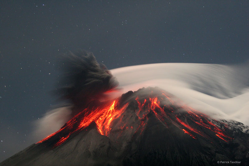
Tungurahua Erupts
Credit & Copyright: Patrick Taschler
Explanation: Volcano Tungurahua erupted spectacularly last year. Pictured above, molten rock so hot it glows visibly pours down the sides of the 5,000-meter high Tungurahua, while a cloud of dark ash is seen being ejected toward the left. Wispy white clouds flow around the lava-lit peak, while a star-lit sky shines in the distance. The above image was captured last year as ash fell around the adventurous photographer. Located in Ecuador, Tungurahua has become active roughly every 90 years since for the last 1,300 years. Volcano Tungurahua has started erupting again this year and continues erupting at a lower level even today.

Click thumbnail for larger image
More information:
Tungurahua, Ecuador
Location: 1.467 S, 78.44 W
Elevation: 16,475 ft. (5023 m)
Tungurahua is an active stratovolcano also known as the “The Black Giant.” It has a 600 ft. (183 m) wide crater. Most of the volcano is covered by snow. It causes many tremors in the nearby city of Banos. Tungurahua’s lava is mostly composed of basalts. Tungurahua has had at least seventeen eruptions in historical times, its most recent occurring in 1944 when it erupted explosively from its central crater. Located about 25 miles (~40 km) west of Tungurahua is the largest volcano in Equador, Chimborazo and to the north about 50 miles(~80 km ) is Cotopaxi volcano.

Spread the word; friends don't allow friends to repeat history.
Leave a Comment » | Geography - Physical, History, Images, Natural history, Science | Permalink
Posted by Ed Darrell


