Tweet from the Department of Interior: 142 years ago today, @YellowstoneNPS became America’s first national park. RT to wish them a very happy birthday! pic.twitter.com/drka6iq0Tc
Ken Burns called the National Parks probably the best idea America has had.
Certainly a great idea — really born on this day, 142 years ago, with the designation of Yellowstone National Park.
Yellowstone NP contains the world’s largest collection of geysers. It is the heart of the largest, nearly-intact temperate zone ecosystem on Earth as well, contained in 3,468 square miles (8,983 km²), a laboratory and playground for geologists, geographers, botanists, zoologists, and almost anyone else who loves the nature and the wild.
Only 142 years old? In the U.S., we have more than 300 units in the National Park System, now, including National Historic Places as well as the best of the wild. Around the world, how much land has been saved, for the benefit of humanity, by this idea? Not enough.
What’s your favorite memory of Yellowstone? What’s your favorite feature?
From National Geographic: Great Fountain Geyser in Yellowstone, the first U.S. national park, erupts every 9 to 15 hours, shooting water up to 220 feet high. Photograph by Michael Melford
Spread the word; friends don't allow friends to repeat history.
Department of Interior caption: Everglades National Park — This Alligator decided he wanted to stand out from all the others along the Anhinga Trail! (SD)
Spread the word; friends don't allow friends to repeat history.
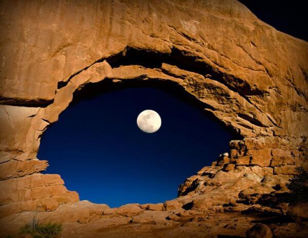
Photo by Lynn Sessions; “THE EYE OF THE #MOON: North Window arch at Arches National Park in #Utah. #NatGeo pic.twitter.com/XwHfdWK5Ft
It’s just a click of the shutter? Ha!
I’m assuming not a lot of post-photo processing on this. Lynn Sessions had to figure out when the Moon would be in the North Window Arch, calculate exposure, and shoot off enough of them to get a decent shot before the Moon moved. I suspect the rocks were “painted” with a flashlight during the exposure.
(Haven’t yet found the technical details of the shot. But I did find this about the photographer:
I’m a frustrated amateur photographer who is trying to visit every corner in Utah as well as hike/photograph every canyon in southern Utah. More at http://www.DreamBreeze.com )
Patience, planning, creativity — then just push the button.
From the U.S. Department of Interior: Really cool reflection photo from America’s largest national park: @WrangellStENPS in #Alaska. pic.twitter.com/WHUYkgJNTH
Wrangell-St. Elias is our largest National Park? At 20,587 square miles, it’s about 80% as large as West Virginia, and larger than nine other states.
Wrangell-St. Elias National Monument was initially designated on December 1, 1978 by President Jimmy Carter using the Antiquities Act, pending final legislation to resolve the allotment of public lands in Alaska. Establishment as a national park and preserve followed the passage of the Alaska National Interest Lands Conservation Act in 1980. The park, which is bigger than the nation of Switzerland, has long, extremely cold winters and a short summer season. It supports a variety of large mammals in an environment defined by relative land elevation. Plate tectonics are responsible for the uplift of the mountain ranges that cross the park. The park’s extreme high point is Mount St. Elias at 18,008 feet (5,489 m), the second tallest mountain in both the United States and Canada. The park has been shaped by the competing forces of volcanism and glaciation. Mount Wrangell is an active volcano, one of several volcanoes in the western Wrangell Mountains. In the St. Elias Range Mount Churchill has erupted explosively within the past 2000 years. The park’s glacial features include Malaspina Glacier, the largest piedmont glacier in North America, Hubbard Glacier, the longest tidewater glacier in Alaska, and Nabesna Glacier, the world’s longest valley glacier. The Bagley Icefield covers much of the park’s interior, which includes 60% of the permanently ice-covered terrain in Alaska. At the center of the park, the boomtown of Kennecott exploited one of the world’s richest deposits of copper from 1903 to 1938, exposed by and in part incorporated into Kennicott Glacier. The mine buildings and mills, now abandoned, compose a National Historic Landmark district.
It’s a rising Moon, with the photo taken from the west side of the Lincoln Memorial, perhaps from the Virginia side of the Potomac River. The Lincoln Memorial is now part of the National Park Service’s portfolio of properties around our national capital.
Update:Jude Crook points out in comments (below) that this was a NASA Photo of the Day, originally; two federal agencies cooperating in the interest of photographic excellence . . .
The full moon is seen as it rises near the Lincoln Memorial, Saturday, March 19, 2011, in Washington. The full moon tonight is called a super perigee moon since it is at its closest to Earth in 2011. The last full moon so big and close to Earth occurred in March 1993.
Image Credit: NASA/Bill Ingalls
Spread the word; friends don't allow friends to repeat history.
A long exposure, you can tell by the airplane streaks near the horizon. Walking that fine photography edge of long enough to get the exposure, but short enough not to distort the stars too much.
Long exposure of a Joshua tree, in Joshua Tree National Park. Photo: Sarah Chah (www.sharetheexperience.org)
Viewed from the road, this desert park only hints at its vitality. Closer examination reveals a fascinating variety of plants and animals that make their home in this land shaped by strong winds, unpredictable torrents of rain, and climatic extremes. Dark night skies, a rich cultural history, and surreal geologic features add to the attraction of this place. Come see Joshua Tree National Park for yourself!
I was born on the Snake River, farther south and west, in Burley, Idaho. It’s a grand river, not so much in the water it moves as the way it moves through the landscape and becomes a part of grander parts of the American west. Kathryn and I honeymooned in Yellowstone, and stayed in Grand Teton on the way out.
There is nothing grander on Earth than a sunrise in the Tetons. Do you think a grizzly appreciates that?
Yeah, gotta get back there.
Spread the word; friends don't allow friends to repeat history.
Yosemite Falls is the tallest waterfall in North America, and is a powerful presence in Yosemite Valley. From winter ice to spring flood to autumn dryness, this magnificent waterfall is a dynamic force of nature.
National Park Service photo of Upper Yosemite Falls
U.S. President Theodore Roosevelt (left) and nature preservationist John Muir, founder of the Sierra Club , on Glacier Point in Yosemite National Park in 1903. In the background: Upper and lower Yosemite Falls. (Photo credit: Wikipedia)
73,117
Spread the word; friends don't allow friends to repeat history.
U.S. Mint‘s Acting Associate Director for Manufacturing, David Croft delivers his remarks. — in Custer, SD.
Interesting view of Mt. Rushmore on the new Mt. Rushmore Quarter.
Here’s David Croft, Acting Associate Director for Manufacturing of the U.S. Mint, introducing the coin yesterday in Custer, South Dakota.
(Wow; how much history is packed in that? Too little of it in the high school texts. Who is on Rushmore? Who made the sculptures on Rushmore, and when? After whom is Custer, South Dakota, named, and why?)
Sign near Mt. Rushmore, South Dakota, informing travelers that the Alfred Hithcock film “North by Northwest” was partially filmed in the area (Photo credit: Wikipedia)
Spread the word; friends don't allow friends to repeat history.
It’s a composite of 11 photographs to get the whole panoramic view — which just demonstrates that in photography it’s great to be lucky, but it usually takes great skill to get that amount of luck.
How much processing was involved, really?
Don’t worry, just check out the photo.
Double Moonbow, lava glow and fading Lunar Halo; 11-picture Panoramic taken on the rim of Kilauea’s Caldera On the Last Super Moon. Sean King, Atmospheric Phenomena
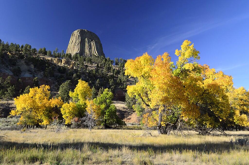
US Dept of Interior @Interior 16h Is there any doubt fall is best enjoyed in America’s great outdoors? Here’s great example from Devils Tower NM. pic.twitter.com/YRo1U8DSMQ
“Devils Tower NM” means “National Monument,” not New Mexico. This volcano remnant stands in Wyoming.
Old friend, painter and photographer Nancy Christensen Littlefield offers a more close-up view.
Devil’s Tower on a July morning. Photo by Nancy Christensen LIttlefield.
And looking even closer, you spy Richard Dreyfus never-wanna-bes:
Climbers on Devils Tower. Photographer Nancy Littlefield said: “There were Native American prayer bundles along the trail around the base. It really is awe inspiring. Early morning gives you the best light to photograph it by.”
Devils Tower is the plug of an old volcano. What’s left is the magma that hardened, and what we see is left after the softer cone eroded away.
Or, until that account is unsuspended by the forces supporting Donald Trump: Follow @FillmoreWhite, the account of the Millard Fillmore White House Library
We've been soaking in the Bathtub for several months, long enough that some of the links we've used have gone to the Great Internet in the Sky.
If you find a dead link, please leave a comment to that post, and tell us what link has expired.
Thanks!
Retired teacher of law, economics, history, AP government, psychology and science. Former speechwriter, press guy and legislative aide in U.S. Senate. Former Department of Education. Former airline real estate, telecom towers, Big 6 (that old!) consultant. Lab and field research in air pollution control.
My blog, Millard Fillmore's Bathtub, is a continuing experiment to test how to use blogs to improve and speed up learning processes for students, perhaps by making some of the courses actually interesting. It is a blog for teachers, to see if we can use blogs. It is for people interested in social studies and social studies education, to see if we can learn to get it right. It's a blog for science fans, to promote good science and good science policy. It's a blog for people interested in good government and how to achieve it.
BS in Mass Communication, University of Utah
Graduate study in Rhetoric and Speech Communication, University of Arizona
JD from the National Law Center, George Washington University


 Posted by Ed Darrell


 and n...")