Stunning southern night sky in Ofu Island in the National Park of American Samoa! They get a brighter, richer view of the Milky Way in the Southern Hemisphere due to the location on the globe. This is the only national park found in the Southern Hemisphere. Photo: National Park Service
Many Americans seem unaware of worldwide holdings of the U.S. in territories, thinking the last territory was closed when Oklahoma or Arizona entered the union, or maybe Alaska or Hawaii. U.S. territories today include the Northern Mariana Islands, Guam (from the Spanish American War), Puerto Rico (from the same war), and the U.S. Virgin Islands, as organized territories. American Samoa is an “unorganized territory,” along with series of other islands in the Pacific: Baker Island, Howland Island, Palmyra Atoll, Johnson Atoll, Jarvis Island, Kingman Reef, the Midway Islands, and Wake Island; and in the Caribbean, Bajo Nuevo Bank, Navassa Island (also claimed by Haiti), and Serranilla Bank, also claimed by Colombia.
Most of these islands offer much better star-gazing than is ever possible in Dallas.
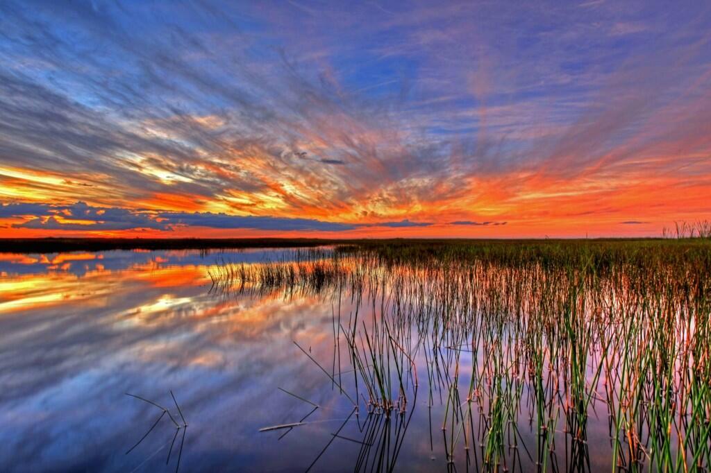
Caption from Interior’s Tweet: Sometimes there are no words to describe America’s public lands. This photo @EvergladesNPS proves it. #Florida pic.twitter.com/3l7fnrcfsG
Everglades National Park, in Florida, is a great example of wild lands that belong to all Americans, that we almost let slip away.
I’m not sure a painter could do a more stunning version of this view.
More:
Location map: Everglades National Park in red. Wikipedia photo
World and U.S. history classes should be long past this point, but the photo just recently surfaced:
From America’s Outdoors: Bering Land Bridge National Preserve – Gone are the shockingly bright pinks, yellows and purples of summer, replaced by deeper and darker reds, yellows, greens and the beginnings of brown, all of equal vibrancy and beauty. And soon, as the 34 degree weather and diminishing daylight would lead us to believe, a blanket of white will fall upon the landscape. Enjoy the change of seasons wherever you may be!
Bering Land Bridge National Preserve? Did you even know there was such a thing? Part of our public lands, your tax dollars at work.
Not a place for a Sunday drive. There are no roads to get to the place. For students, this site offers a lot of photos and interesting stuff for projects in history (human migrations) and geography (land forms, lava flows, migration routes, wilderness).
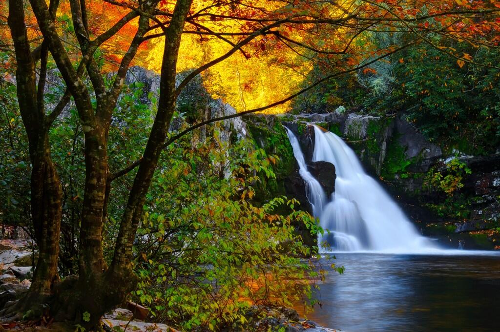
US Dept of Interior @Interior 16 Sep Department of Interior Tweet: It doesn’t get much prettier than this. Abrams Falls in Great Smoky Mountains National Park. #Tennessee pic.twitter.com/S5dQgcffEZ
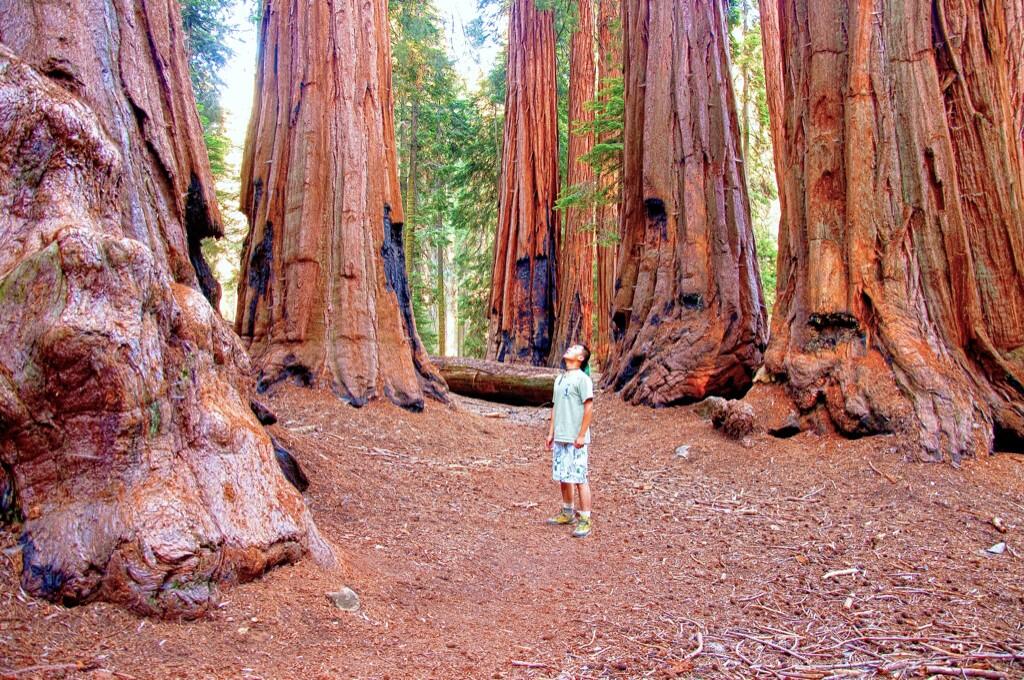
USDA/Flickr photo via Mother Jones: A National Park Service fire crew builds a sprinkler system around a grove of sequoias. USDA/Flickr
It’s a rolling tragedy, in time-lapse. Fire always offers a chance at beauty, if we don’t think about the destruction the fire wreaks.
A lot of cameras around Yosemite, and some were set to do time-lapse photos of the recent Rim Fire. One hopes there is some academic value to these films, perhaps in demonstrating how the diurnal rhythms of the atmosphere changes the behavior of fire (notice how smoke often changes directions at sunset, and then at sunrise, and back again).
All that smoke. Much of it was living plant material just a few weeks ago, and we watch it turned to tiny particles and gases, and spread by the winds.
More information from the filmmakers and posters:
Published on Aug 28, 2013
Time-lapse photography shows various perspectives of the 2013 Rim Fire, as viewed from Yosemite National Park. The first part of this video is from the Crane Flat Helibase. The fire [was] . . .burning in wilderness and . . . not immediately threatening visitors or employees. The second half of the video is from Glacier Point, showing Yosemite Valley, and how little the smoke from the fire has impacted the Valley.
In this next piece, you’ll see footage of fire fighting operations, including a back-burn, and helicoptering of supplies to firefighters on the front lines. It’s the non-time-lapse version, with wildtrack sound.
Published on Sep 7, 2013
Fire crews in Yosemite conducted firing operations along the Tioga Road this week to provide a buffer of protection from the Rim Fire. As you can see in this video, the fire mostly burns debris on the forest floor rather than the trees. It’s only when the forest floor accumulates too much debris or too many young trees that a small fire like this gets hot enough to torch mature trees and spread from treetop to treetop.
Later in the video, we give you a behind-the-scenes peek at Yosemite’s Helicopter 551 ferrying supplies from the Crane Flat helibase.
The timelapse, from August, has over a million-and-a-half views on YouTube; the non-timelapse, a few weeks later, has fewer than 6,000 views, as I write this. Time-lapse is very popular.
Normally I might just let this beautiful photo slide by without comment.
In this case, I find this particularly frustrating. See that creature? That’s the same goat that blocked my trail in Glacier National Park. I’m sure of it. I’d recognize those beady eyes and horns anywhere! (See the first story linked to in the “more’ section; maybe this goat stopped in Washington on the way to Alaska.)
He’s probably in Alaska now under the Federal Goat Protection Program.
Interior US Dept of Interior 6h Caption from the Department of Interior: That’s quite the hike to the top. Harding Icefield Trail @KenaiFjordsNPS. #alaska pic.twitter.com/yozsSLnrcD
He probably thinks he’s safe there at Kenai Fjords National Park. Ha! He’s farther away, but that just means I have farther to travel to find him!
I’m taking a longer telephoto, a wide angle, and a first aid kit, next time. I’ll be prepared!
Can the scientist appreciate the beauty of creation as much as the non-scientist religious person?
Can you get the joke in this photo, without a smattering of knowledge of geography, and languages? Or am I looking at it wrong?
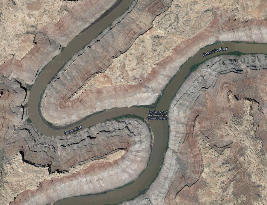
Confluence of the Green and Colorado Rivers, in Canyonlands National Park. Photo by Jim Collins, posted on Facebook by Canyonlands National Park
It’s a joke on a planetary scale, if not a cosmic one.
(Hints: This is a photo looking from the north, I think; “Colorado” means “red” in Spanish.)
Update: Okay, Mr. Higginbotham convinced me. We’re looking from the west, and that’s the Colorado coming from the top of the picture, and the Green coming from the bottom left; then the conjoined streams flow away, to the bottom right. So, in the photo, the Colorado River is, appropriately, red, while the Green River is, fittingly, green
Not a majestic joke by Mother Nature, but a poetic way to remind us of the names of these rivers.
Poetry that might make us smile, too.
(It’s rare that these rivers run such dramatically different colors, especially with the Colorado that red, that far north.)
Google Maps aerial photo of the Confluence of the Green and Colorado Rivers; match the geography with the other photo, and note the labels on this one. Rotate this picture 90 degrees to the left, it matches up better. Tip of the old scrub brush to Mr. J. A. Higginbotham.
Superior Fury – Lake Superior near Miner’s Beach in Pictured Rocks National Lakeshore during a gale at sunrise. Photo: Steve Perry, via America’s Great Outdoors
Admit it: That’s not how you usually think of Lake Superior, is it?
(This is not a place to bolster creationist ideas. This is real science, looking at God’s handiwork first hand.)
A North Carolina university makes field trips to Yosemite? I’d love to take that class!
Watching this film, you get a sense of how important it can be to the education of our children to travel in the summers, to take vacations to our National Parks, and to places like Yosemite.
Where are you taking your kids this summer? Kids, where are you going?
Enjoy it. Geology lessons are often fun, and this one, on film, is more fun than most.
As ordered reported by the Senate Committee on Energy and Natural Resources on June 18, 2013.
CBO estimates that enacting this legislation to name a peak in Alaska would have no significant impact on the federal budget and would not affect direct spending or revenues; therefore, pay-as-you-go procedures do not apply. S. 155 contains no intergovernmental or private-sector mandates as defined in the Unfunded Mandates Reform Act and would not affect the budgets of state, local, or tribal governments.
Calling a mountain by its name won’t affect the budget? Good news, I’m sure. Shakespeare was right.
STATEMENT OF PEGGY O’DELL, DEPUTY DIRECTOR FOR OPERATIONS, NATIONAL PARK SERVICE, DEPARTMENT OF THE INTERIOR, BEFORE THE SUBCOMMITTEE ON NATIONAL PARKS OF THE SENATE ENERGY AND NATURAL RESOURCES COMMITTEE, CONCERNING S. 155, TO DESIGNATE A MOUNTAIN IN THE STATE OF ALASKA AS DENALI.
April 23, 2013
Mr. Chairman, thank you for the opportunity to present the Department of the Interior’s views on S. 155, a bill to designate a mountain in the State of Alaska as Denali.
The National Park Service appreciates the long history and public interest for both the name Mount McKinley and the traditional Athabascan name, Denali. The Department respects the choice made by this legislation, and does not object to S. 155.
Located in what is now Denali National Park and Preserve, the highest peak in North America has been known by many names. The National Park Service’s administrative history of the park notes that, “The Koyukon called it Deenaalee, the Lower Tanana named it Deenaadheet or Deennadhee, the Dena’ina called it Dghelay Ka’a, and at least six other Native groups had their own names for it.
“In the late 18th century various Europeans came calling, and virtually everyone who passed by was moved to comment on it. The Russians called it Bulshaia or Tenada, and though explorers from other nations were less specific, even the most hard-bitten adventurers were in awe of its height and majesty.
“No American gave it a name until Densmore’s Mountain appeared in the late 1880s, and the name that eventually stuck—Mount McKinley—was not applied until the waning days of the nineteenth century,” a gesture of support to then-President William McKinley.
In 1975, the State of Alaska officially recognized Denali as the name of the peak, and requested action by the U.S. Board on Geographic Names to do the same.
In 1980, Congress changed the name of Mount McKinley National Park to Denali National Park and Preserve (P.L. 96-487, Section 202), but did not act on the name change for the mountain.
Caption from America’s Great Outdoors: There are many unique areas within America’s public lands. Case in point this spot in Glen Canyon National Recreation Area. Photo: Cassandra Crowley
Brad Goldpaint (Goldpaint Photography) planned to shoot pictures of the Milky Way, something I’ve tried to do without much success, at Crater Lake National Park, one of the more spectacular backdrops for such a photograph.
Those plans were interrupted — without warning. Thank goodness.
I drove to Crater Lake National Park on the night of May 31, 2013 to photograph the Milky Way rising above the rim. I’ve waited months for the roads to open and spring storms to pass, so I could spend a solitude night with the stars. Near 11pm, I was staring upward towards a clear night sky when suddenly, without warning, an unmistakable faint glow of the aurora borealis began erupting in front of me. I quickly packed up my gear, hiked down to my truck, and sped to a north facing location. With adrenaline pumping, I raced to the edge of the caldera, set up a time-lapse sequence, and watched the northern lights dance until sunrise. The moon rose around 2am and blanketed the surrounding landscape with a faint glow, adding depth and texture to the shot. The last image in the sequence above shows the route of the International Space Station (ISS) which flew over at 2:35am.
No motion control systems were used during the production of this time-lapse. We are actively seeking various marketing partnerships to strategically promote and develop, specialized photography equipment used in the field. If you are interested in soliciting your product with Goldpaint Photography, please contact us at info@goldpaintphotography.com.
Poetic understatement: ” . . . without warning, an unmistakable faint glow of the aurora borealis began erupting in front of me.”
This is what it looks like at Officers Row, at Mammoth Hot Springs in Yellowstone National Park:
Yellowstone National Park “On this Memorial Day, American Flags are proudly displayed on Officers’ Row in Mammoth Hot Spring as we remember those who gave their lives in military service to our country. (dr2)”
Or, until that account is unsuspended by the forces supporting Donald Trump: Follow @FillmoreWhite, the account of the Millard Fillmore White House Library
We've been soaking in the Bathtub for several months, long enough that some of the links we've used have gone to the Great Internet in the Sky.
If you find a dead link, please leave a comment to that post, and tell us what link has expired.
Thanks!
Retired teacher of law, economics, history, AP government, psychology and science. Former speechwriter, press guy and legislative aide in U.S. Senate. Former Department of Education. Former airline real estate, telecom towers, Big 6 (that old!) consultant. Lab and field research in air pollution control.
My blog, Millard Fillmore's Bathtub, is a continuing experiment to test how to use blogs to improve and speed up learning processes for students, perhaps by making some of the courses actually interesting. It is a blog for teachers, to see if we can use blogs. It is for people interested in social studies and social studies education, to see if we can learn to get it right. It's a blog for science fans, to promote good science and good science policy. It's a blog for people interested in good government and how to achieve it.
BS in Mass Communication, University of Utah
Graduate study in Rhetoric and Speech Communication, University of Arizona
JD from the National Law Center, George Washington University


 Posted by Ed Darrell