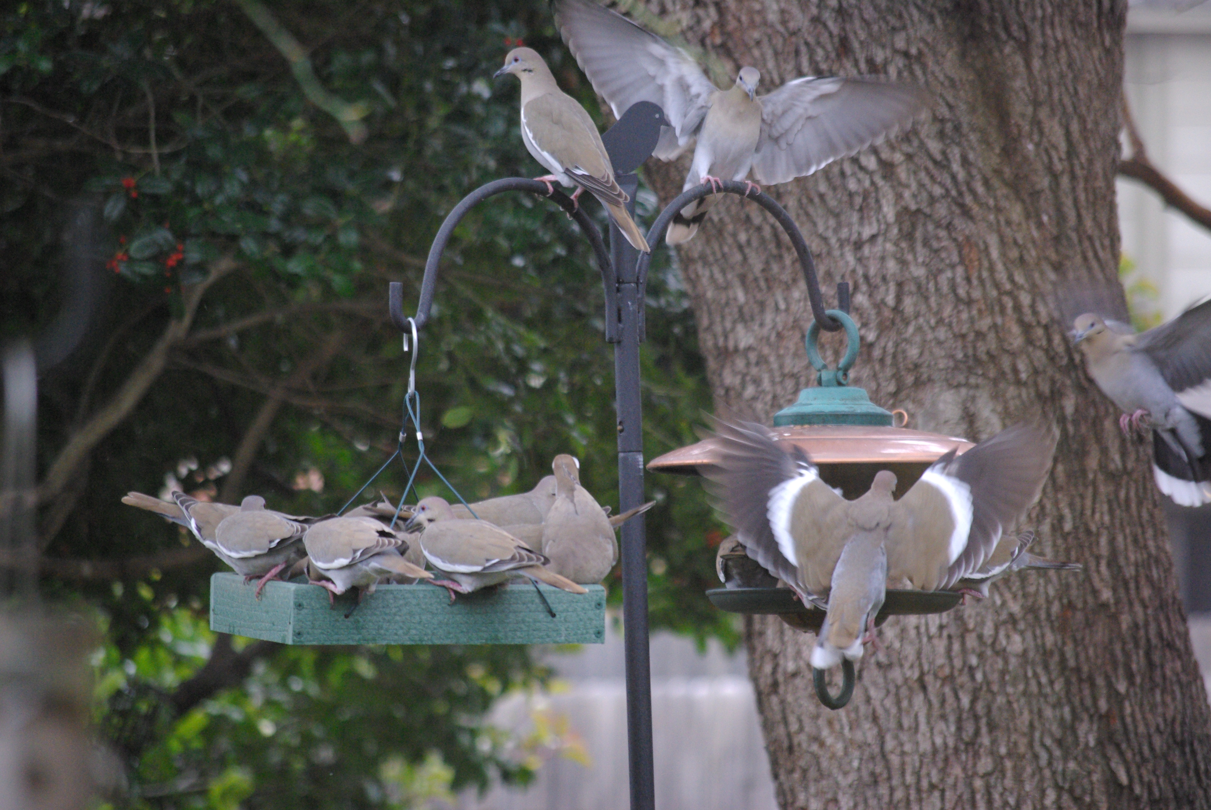
The white dove was a short-lived interlude; the white-winged doves seem to be with us constantly.
One family in 2011; two families in 2012 — and our yard isn’t that big.
A very early version of the birds who visited, befriended, and plagued Snoopy — this drawing, while faithful to Shultz’s work, was done by another artist.
Earlier this week I looked out, and it looked like the early “Peanuts” comic strip when Snoopy opened his dog house to a group of pigeon-like birds for their poker game. The birds took advantage of Snoopy’s largesse, and nearly over-ran him. (Woodstock was a product of that flock of birds, the last remaining vestige by Charles Shultz‘s death.)
At least they didn’t drink our beer and try to make off with the Picasso.
White-winged doves are really too big for any of our feeders — but what are you going to tell a rampaging herd of them? Photos by Ed Darrell – use encouraged with attribution.
Enough doves to frighten Alfred Hitchcock — Two of these birds is too many for either side of this feeding station. How many do you see here?
Not enough room for all, and so they jostle and push each other off the feeders. See the display of the white stripe on the wings of one of our subjects here, from which the species gets its name.
Blue jays enforce the “too-long-or-too-many-at-the-feeder” rules here, but they can be distracted by peanuts put out by neighbors. In any case, they were absent when we needed them.
We used to have mourning doves, but at some point in the last five years this bunch pushed them out. We may be the only ones on the block who noticed. (Yes, it’s “mourning” dove; Duncanville’s having misspelled it on “Morning Dove Lane” is their error.)
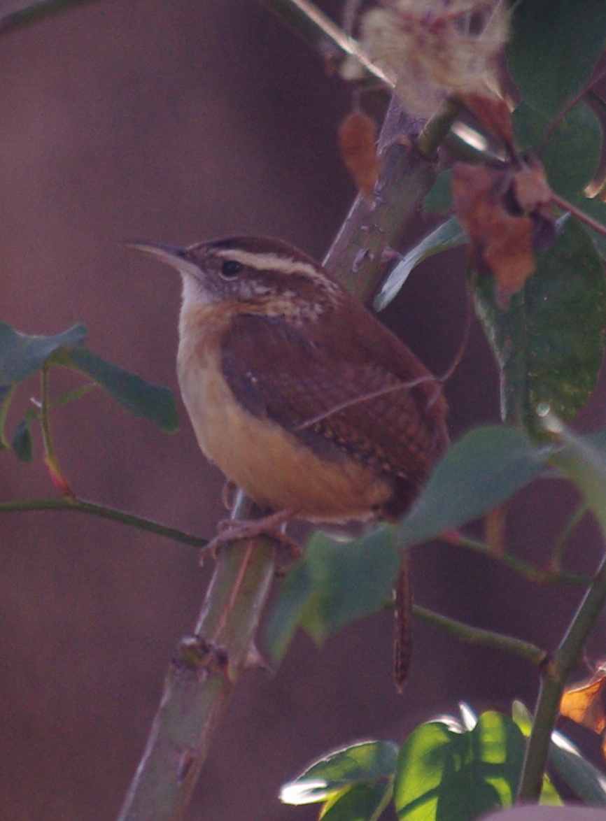
I’ve been calling these guys Bewick’s wrens (Thryomanes bewickii) for a couple of years, based on an identification I made a couple of years ago — but checking today to be sure, I’m thinking this is a Carolina wren (Thryothorus ludovicianus) instead.
In any case, a couple of days ago it paused for a few minutes in our backyard rose arbor, long enough I could try to get a good shot with just a 200mm telephoto, and with colors dulled by the window.
Wren in the rose arbor — ruddy color suggests it’s a Carolina wren, but I’ve been calling it a Bewick’s wren; pausing for its photo on Inauguration Day – Photo by Ed Darrell
Bewick’s wrens probably have more grey on their bellies; this one looks ruddy enough to be a Carolina wren. (I just learned “Bewick’s” is pronounced like “Buicks.”)
Wrens stick around all winter now; they didn’t just over a decade ago. This family has been with us for at least three years — two young this year successfully fledged. By now it’s almost impossible to tell which are the young, which the parents.
Gulf fritillary butterfly on blue porterweed — a few feet from the rose arbor where the wren posed, but months apart. Photo: Ed Darrell
On our patio we have a saga continuing with Gulf fritillary butterflies (Agraulis vanillae), their larva, and passion vine. It seems our neighbors eradicated passion vine, so when the frits start moving north in the spring, they find our passion vines as the only ones in town. The females go nuts laying eggs, and at some point we have a surplus of larva who denude the vines in a week. Late hatching larva probably die off.
The butterfly books suggest that we cull the larva, but we don’t have the heart. At some point in the spring the wrens wake up to the issue, and they cull the larva for us. The vines recover, a new wave of frits hatch out, and the cycle begins again. From June through September, the passion vine loses any leaves it puts out within 48 hours, usually. But the wrens probably eat well.
The wrens seem never to perch where we can see them when they sing. I suspect these little guys of having a much better voice than most wrens, but the great arpeggios I hear may be another bird, perhaps a warbler, that I just don’t know (good reason to go spend time at the local DogwoodCanyon Audubon Center, yes?).
Sunset on BLM land near the Little Snake River, in northwest Colorado. Photo by Shannon Diszmang, via Royal Gorge National Recreation Area.
Note from America’s Great Outdoors blog:
Earlier this year, the Royal Gorge Recreation Area staff had a photo contest on their Facebook page and here is one of the great photos that was submitted. Here’s what photographer, Shannon Diszmang, had to say about it.
“This is BLM land in Northwest Colorado (Little Snake River district). I fell in love with this place. The red haze in this photo is the smoke coming from the wildfires on the west coast at the time. This is one of the lowest light pollution spots in our state which makes star gazing the absolute best.”
So, if you’re nearby, and you want a good place to look at the Geminid meteor shower tonight, odds are high there will be little light pollution here. If there aren’t many clouds, you’re in luck.
P.S.: The stunningly beautiful photo above is NOT the winner of the photo contest(!). BLM wrote in a November press release:
CAÑON CITY, Colo. – Today the BLM Royal Gorge Field Office announced the winners of its BLM-sponsored photo contest. The two winners were decided by the public via the RGFO’s Facebook page: one winner is based on the most “likes” and the other is based on the most “shares.” Only those “likes” and “shares” that originated from the Royal Gorge Facebook page were tallied towards a winner.
Both photos will be featured on the RGFO’s Facebook page throughout November and may be featured in future BLM Colorado publications and social media sites.
The photo contest began Oct. 2 and ended Nov. 4 with more than 60 photos submitted. All the photos that were entered into the contest may be viewed via the “Photo Contest” album on the RGFO’s Facebook page: http://www.facebook.com/BLMRoyalGorge
Yeah, were I you, I’d go see what the winners looked like.
Spread the word; friends don't allow friends to repeat history.
Temple of the Sun, Capitol Reef NP, photo by Mike Saemisch, October 29, 2012
First you must get to Capitol Reef National Park, in Utah — one of Utah’s unfairly large number of five National Parks. Then you take your “high-clearance vehicle” (not necessarily 4-wheel drive) out on the dirt roads in Cathedral Valley, and you hope for a crystal blue sky like this one. Then you happen to get there just as the sun is right at the peak of the formation . . .
You had to be there. Mike Saemisch was there just over a week ago, on October 29, 2012, and fortunately caught this photograph with the Sun as part of a sparkling spire on a sandstone formation known as the Temple of the Sun.
Digital photography changes the way one tours these places. Fortunately. Take the kids, and make sure they find it on a map so they can use your trip as fodder for their 9th grade geography class.
More:
See Hal’s photos here, at his blog. He’s also got posts on Bryce Canyon NP and Kodachrome Basin State Park, with Grosvenor Arch, named after the father of our old friend Gil Grosvenor. Kodachrome, alas, is a thing of the past, killed by digital photography. Be sure to take a good digital camera and a clear memory chip when you go, to honor the name of the place, and the Grosvenors (of National Geographic Society fame). Kathryn and I spent great night as one of only two groups camping in Kodachrome Basin, near the height of tourist season in August, in the 1980s. We got there in a Chrysler Cordoba; better to use at least an SUV.
A different angle, at a different time, by Scott Jarvie: “A 3.5hr timelapse taken late on a cloudy night at the Temple of the Moon with the Temple of the Sun in the background. March 17, 2012.”
Spread the word; friends don't allow friends to repeat history.
National Parks really are a tiny part of the federal budget. Consequently, they get overlooked, and that could be bad.
How are your Congress and Senate candidates standing on these issues?
Romney’s “energy plan” calls for opening up the National Parks for oil and gas exploration and drilling, even the Flight 93 Memorial in Pennsylvania Bet that’s not mentioned by anyone in the debate tonight.
Which one is your favorite unit of the National Park System? What’s your favorite family story from visiting the parks? How are you going to vote in November?
Yosemite’s vast acreage and remote location protect some of the darkest night skies in the country. Astronomers, photographers and city dwellers flock to the park to take advantage of this unique opportunity to view planets, stars, and galaxies.
For classroom use, some topics and questions to pursue:
For geography, where is Yosemite N.P.? Flying commercially, which airport is the best to get to the park?
President Teddy Roosevelt and conservationist John Muir pose at Overhanging Rock at the top of Glacier Point, near which the men camped in a hollow and awoke to five inches of snow in 1903. National Park Service image
Map reading and orientation: In the time-lapse sequences, you can frequently see lights streaking across the sky. Those are commercial airliners — can you tell what airport they are headed to, or from? Can you tell which ones are coming, which going?
Science: What star formations do you see in these photographs that you can see from your house? What star formations are not visible from your house?
Government: Who signs the checks that pay the rangers pictured in the film? For which agency do the work, in which branch of which government?
People in the film discuss light pollution from nearby cities. Is there an agency in the federal government who has jurisdiction over light pollution? How about an agency in the state government? What are the rules on light pollution for cities around Yosemite?
Can you identify the landmarks, the cliffs, rocks, mountains and rivers, portrayed in the film? (Students might use a USGS topographical map, California state tourist promotion maps and websites, National Park Service databases, Google Earth, Google, and a wide variety of other sources.
Who was president of the U.S. when Yosemite was set aside as a National Park, and what were the controversies surrounding it?
Who lived in Yosemite, if anyone, before the Spanish missions were established in California? When were the missions established? How did the U.S. gain possession of the Yosemite Valley?
Spread the word; friends don't allow friends to repeat history.
Interior Department photo, America’s Great Outdoors, at Denali National Park and Preserve; photo caption from AGO said, “We’re not sure it’s possible to take a bad photo up there!” Click for larger view.
Update: Interior tweeted another photo later today.
From the U.S. Department of Interior Tweet: This morning we gave you an amazing shot of #Denali. Would you believe this one is from the same place? Whether large or small, beauty in Denali is everywhere you look. #Alaska
Can someone identify the flower?
Spread the word; friends don't allow friends to repeat history.
Turk’s cap is a native Texas shrub that attracts hummingbirds, butterflies and moths. This easy-to-care for plant is named for the shape of its small blooms. To learn more about Texas native species and habitats, see http://www.tpwd.state.tx.us/huntwild/wild/wildlife_diversity/
Must admit I was unaware it’s a Texas native, though Kathryn has had it in all of our Texas gardens. I love the blossoms. I wish our local hummingbirds loved it as much as the photo in the video shows, but we have other plants they love and a feeder. Butterflies like it, too.
Few other plants equal the intense red of the flowers. Turk’s cap requires less water than many less spectacular, non-native plants. Ours keep coming back year after year. What more do you want in a good garden plant?
I wish my photos were so good as those used in the film.
Our Scout Troop readies for two summer camp excursions this summer, and Kathryn and I hope to get out somewhere not drought stricken for at least a weekend. Generally we tack on a whitewater river run on the Scout trips, if we can find a good one for reasonable price. Safety instructions always include the solid order to wear a Personal Flotation Device (PFD) at all times. We have a few adult leaders trained in Safety Afloat, and we work to have the Scouts up to “swimmer” or “lifesaver” ability for the trips.
It’s a good idea to review all the rules for safety near water in the great outdoors.
The good video crew at Yosemite National Park posted this dramatic video story — please watch, and heed the warnings. Doesn’t matter how well you swim, if you get pinned underwater by a powerful flow — and they are all powerful — you’re in trouble. This story has a happy ending with chastened hikers who learned uncharted short cuts may not be a good idea. For nearly a score of people in Yosemite NP the turnout was not wonderful, in the last ten years.
In Texas, drownings take about a hundred lives a year, averaging 81 child drownings each year: “An average of 81 children drowned each year since DFPS [Department of Family Protective Services] began tracking these deaths in 2005. DFPS identified 76 water fatalities in 2005, 70 in 2006, 63 in 2007, 82 in 2008, 113 in 2009 and 84 in 2010, and 79 in 2011 as of August 31, 2011.” [If you can find figures including adult drownings, please let us know in the comments.]
Please watch, and pass along to anyone you know who will be hiking this year.
Text from the filmmakers:
Sixteen people died in Yosemite’s rivers and creeks between 2002 and 2011. Water in Yosemite is more dangerous than it looks, and stories like Matthew’s are a common occurrence.
Go outside, have great fun, see America. Be careful when you do.
Spread the word; friends don't allow friends to repeat history.
It was billed as a “hike” that might take 2.5 hours, but David Hurt, the grand benefactor of Dogwood Canyon Audubon Center, was the guide — at the two hour mark we had just ambled to the blossoming trees in their still-semi-secret location. Amble, not a hike.
Great day to be outside.
David Hurt spent 14 years working to establish the reserve and education center at Dogwood Canyon, in Cedar Hill, Texas — now he just can’t resist leading tours of the better sites and sights.
The voyage is at least half the fun.
After more than a year of serious drought, some of North Texas experienced high rainfall in the past three months. Spring-fed streams and seeps on Cedar Hill and across the Escarpment flow well for the moment, lending hope to wild bird breeding. On some entangled bank . . .
Mr. Hurt often stopped to explain bird songs and habits, and despite his claim not to like “plant people,” he stopped most often to identify plants, or to compare plants that can be confused. This Audubon facility sits in a transitional zone, between two kinds of prairies. It’s forest nature is an oddity in the zone. Dogwood Canyon features plants more commonly identified with the Texas Hill Country and with East Texas, as well as Blackland Prairie plants considered icons of the area. In this case, Hurt showed the differences between Texas redbud and eastern redbud, both of which occur in this area. Hurt carefully demonstrated how to identify poison ivy, now in abundance off the trails. This was a sharp contrast to two weeks ago when I couldn’t find a single sprig of poison ivy to show Scout leaders.
Poison ivy along the trail. Keep away.
Is it eastern red oak, or something else? How to tell?
Hurt showed how to make a nest from loose bark strips from Ashe juniper trees. Golden-cheeked warblers, a threatened species, require this bark for nesting, and it can come only from mature Ashe junipers. The birds need this nesting material close to a good stand of deciduous trees, where they catch their food.
The dogwoods in bloom! An early spring, and lots of water, pushed the trees to leaf out before blossoming started — usually the blossoms come first. The drought last year probably hurts blossoming this year. Blossoms are not yet at their peak.
Exquisite aroma and beauty from the dogwood blossoms – not the carpet of white we saw in a previous year. Still just the shock of finding these little beauties in Dallas County adds to their splendor. Dogwoods do well in East Texas, where it is wetter and the soil is acid. Here on the escarpment it is generally dry, hotter, and the soil is thin and alkaline. That the blossoms show up at all is a stunning oddity, a stroke of fortune emblematic of the unique place that is Dogwood Canyon.
I do love the tops of mountains, and I wish I could climb them. Fortunately, there are cameras, people who know how to use them, and people who know how to edit film to tell a story, and put us all in awe.
Plus, living among us are people brave enough and skilled enough to get to the tops of those mountains, people who make the filming possible and worthwhile.
In summer 2010, Lorna Illingworth, Madaleine Sorkin and I spent 25 days in the Cirque of the Unclimbables, Northwest Territories, Canada. Our goal was to free climb the entire 1963 Original Route on the sheer 2000′ Southeast Face of Proboscis, and grants from the American Alpine Club encouraged us to document the adventure. The result: Women at Work (VI 5.12 R).
Geography: Off the Nahanni River, now in the expanded Nahanni National Park, in the Northwest Territories near the border with the Yukon Territory — see maps below.
Dick Feynman taught in Rio de Janeiro for a while. He was frustrated at the way Brazilian students of that day learned physics by rote, instead of in labs. In a lecture he looked out from the classroom to the sun dancing on the waves of the Atlantic, and he realized it was a beautiful, brilliant demonstration of light refraction, the topic of the day. Sadly, the students didn’t understand that the beauty before them was a physics problem. (Was that story in Surely You’re Joking, Mr. Feynman, or What Do You Care What Others Think?)
Here, a marriage of physics, moonlight, spring runoff over a cliff, and modern photography, in Yosemite. If you don’t gasp, call your physician and find a new sensei:
(Programs and maintenance of this park are threatened by Republican budget writers, BTW.)
Spread the word; friends don't allow friends to repeat history.
It took me a couple of tries to figure it out — last week when I told people Kathryn and I were off to Colorado Bend State Park to spend time on the river, several people commented about how much cooler it would be there.
What? West of Killeen about an hour, ten miles of dusty road outside of Bend, Texas (population 1,637), Colorado Bend is not cooler than Dallas. It was over 100° F every day we were there, stayed well above 90° most of the nights.
Kathryn studied wildflowers at a spring at the side of the Colorado River during a break from kayaking; this spring's flow was reduced, but still moist enough to create a near-oasis.
Our well-wishers were geographically confused. They thought we were headed to the Colorado River in Colorado, not the Colorado River in Texas, which is not the same river at all. I didn’t bother to check the temperatures in Colorado, but one might be assured that it was cooler along the Colorado River in Colorado than it was along the Colorado River in Texas.
It was a return trip. We stumbled into the park 16 years ago with the kids, for just an afternoon visit. The dipping pools in the canyon fed by Spicewood Springs captivated us. It took a while to get back, and then the kids were off doing their own thing.
So, just a quick weekend of hiking/camping/kayaking/soaking/stargazing/bird watching/botanical and geological study. Park officials closed the bat caves to human traffic in hope of keeping White Nose Syndrome from the bats; we didn’t bother to sign up for the crawling cave tour through another.
The author, still working to master that Go-Pro camera on the hat -- some spectacular shots, but I don't have the movie software to use it all; you know it's hot when SPF 75 sunscreen is not enough.
What did we see? Drought has a firm grip on Texas, especially in the Hill Country, especially outside of Dallas. The Colorado River is mostly spring fed; many of the springs are dry. No water significant water flowed through the park while we were there — kayak put-ins have been reduced to the downriver-most ramp, and the bottom of the boat launch ramp is three feet above water. Gorman Falls attracts visitors and scientists, but the springs feeding it are about spent this year — just a few trickles came over the cliff usually completely inundated with mineral-laden waters.
Drought produces odd things. The forest canopy around the park — and through most of the Hill Country we saw — is splattered with the gray wood of dead trees, many of which at least leafed out earlier this spring. The loss to forests is astonishing. Deer don’t breed well in droughts; deer around the campsites boldly challenge campers for access to grasses they’d ignore in other seasons. One ranger said he hadn’t seen more than about three fawns from this past spring, a 75% to 90% reduction in deer young (Eastern White Tail, the little guys). Raccoons are aggressively seeking food from humans, tearing into tents and challenging campers for food they can smell (lock your food in the car!). Colorado Bend is famous for songbirds, including the endangered Golden Cheeked Warbler, and the elusive, spectacular painted bunting. But the most commonly-sighted birds this year are turkey vultures, dining on the young that didn’t make it healthy into the summer and won’t survive until fall.
Warming denialists’ claims of “not so bad a drought” ring out as dangerous, wild delusion. (By actual measurement, Texas average rainfall the past nine months was 8.5 inches, the driest ever recorded in Texas, shattering the old record drought of 1917).
Great trip. Kathryn’s menu planning was spectacular. The old Coleman stove — a quarter century old, now, with fuel almost that old — performed like a champ even without the maintenance it needs (later this week). Other than the hot nights, it was stellar.
Stellar. Yeah. Stars were grand. It was New Moon, a happy accident. A topic for another post, later. Think, “Iridium.”
So posting was slow over the weekend. How far out in the Hill Country were we? Neither one of us could get a bar on our phones. We were so far out the Verizon Wireless guy was using smoke signals.
Thoreau was right, you know.
Spread the word; friends don't allow friends to repeat history.
Heck, I’ve missed it every year since its inception in 1993.
As usual, I’ll have to hit the trails later in the summer — hello, Colorado Bend State Park. You can make it up, too. National Trails Day is a celebration that can be done any time you find to do it, really, any place you find to celebrate it.
So, hey, buddy: Take a hike!
And have fun doing it.
Information and resources for National Trails Day:
Or, until that account is unsuspended by the forces supporting Donald Trump: Follow @FillmoreWhite, the account of the Millard Fillmore White House Library
We've been soaking in the Bathtub for several months, long enough that some of the links we've used have gone to the Great Internet in the Sky.
If you find a dead link, please leave a comment to that post, and tell us what link has expired.
Thanks!
Retired teacher of law, economics, history, AP government, psychology and science. Former speechwriter, press guy and legislative aide in U.S. Senate. Former Department of Education. Former airline real estate, telecom towers, Big 6 (that old!) consultant. Lab and field research in air pollution control.
My blog, Millard Fillmore's Bathtub, is a continuing experiment to test how to use blogs to improve and speed up learning processes for students, perhaps by making some of the courses actually interesting. It is a blog for teachers, to see if we can use blogs. It is for people interested in social studies and social studies education, to see if we can learn to get it right. It's a blog for science fans, to promote good science and good science policy. It's a blog for people interested in good government and how to achieve it.
BS in Mass Communication, University of Utah
Graduate study in Rhetoric and Speech Communication, University of Arizona
JD from the National Law Center, George Washington University


 Posted by Ed Darrell