May 30, 2014
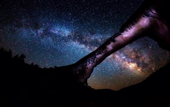
From the Department of Interior’s Twitter feed: Looking for a wow photo? This picture of the Milky Way over Natural Bridges Natl Monument should do the trick. pic.twitter.com/RfuDj7KXSA
Owachomo Bridge? Photographer? I wish Interior would put in all the details with their photos.
Spread the word; friends don't allow friends to repeat history.
 3 Comments |
  Astronomy, National Parks, photography, Travel, Utah | Tagged: Arches National Park, Astronomy, Milky Way, photography, Travel, Utah |
  Permalink
 Posted by Ed Darrell
May 20, 2014
Photo after photo, I come increasingly to understand why my oldest brother, Jerry, wanted to spend his life and eternity in the Yellowstone.
Wholly apart from the thermal “features” and geological wonders, the area is just smashingly beautiful day in and day out, in even the mundane areas away from the celebrated features.
Here’s a part of the Madison River, just flowing through its streambed, at sunset.
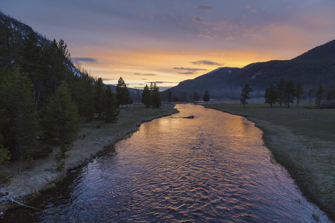
Yellowstone National Park’s Twitter feed: Spring sunset on the Madison River. pic.twitter.com/8nZSxJvBeZ
Spread the word; friends don't allow friends to repeat history.
Leave a Comment » | photography, Public Lands, Travel, Yellowstone | Tagged: Madison River, photography, Public Lands, Travel, Yellowstone National Park | Permalink
Posted by Ed Darrell
May 18, 2014
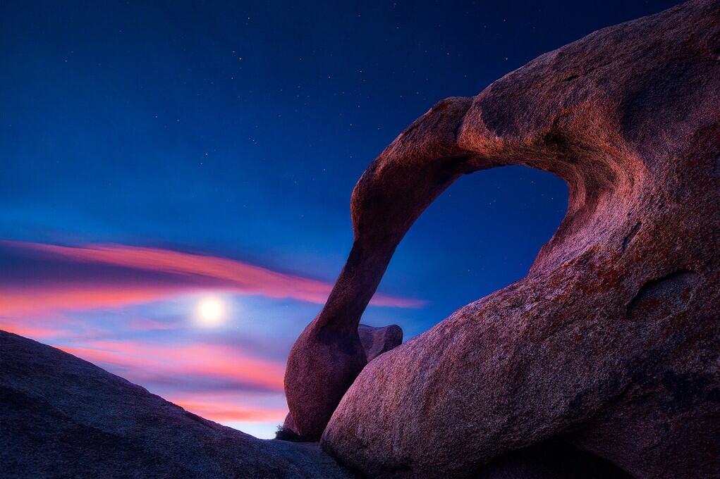
U.S. Department of Interior, Twitter feed: Beautiful view of the Moon over Mabius Mobius Arch in the Alabama Hills Recreation Area. #California @BLMca pic.twitter.com/u0KYyJ6p0S
Interesting points, reasons to like this image:
- No, that’s not the Sun. It’s the Moon.
- Who knew California had natural arches? I mean, it makes sense — but there’s one in Virginia, and a bunch of them at Arches National Park, and . . .
- An arch that should be in Utah, in the Alabama Hills, but not in Alabama, in California.
- Stars!
- Great photograph, obviously a long exposure.
Let’s see if we can find the name of the photographer. Pox on Interior for failing to fit that into the caption. Photographer is Steve Perry, and you should check out his site (and buy some photos!). (Thanks, J. A. Higginbotham, for tracking that down.)
- America’s public lands, showing how they are unexcelled at astonishing us.
- What? Interior called the “Mabius Arch?” No, it’s the Mobius Arch!
- This place was named after the Confederate warship C.S.S. Alabama. Sympathetic miners making claims on minerals, it appears. “The unusual name Alabama Hills came about during the Civil War. In 1864 Southern sympathizers in Lone Pine discovered gold ‘in them thar hills.’ When they heard that a Confederate cruiser named the Alabama had burned, sunk or captured more than 60 Federal ships in less than two years they named their mining claims after the cruiser to celebrate. Before long the name applied to the whole area. Coincidentally, while Southerners were prospecting around Lone Pine, there were Union sympathizers 15 miles north near Independence. And when the Alabama was sunk off the coast of France by the U.S.S. Kearsarge in 1864, the Independence people struck back. They not only named their mining claims ‘Kearsarge’ but a mountain peak, a mountain pass, and a whole town as well.”
- More than 400 movies were shot using Alabama Hills for a backdrop, including How the West Was Won, Gunga Din (standing in for the hills of northern India) and the 1960 Audie Murphy classic, Hell Bent for Leather.
- Geologists will love that this area is a prime example of chemical erosion — rocks made out of the same stuff as the craggy Sierra Nevada Mountains in the distance, but eroded differently.
- Lichens by moonlight! (Or is that just desert varnish?)
More:
- Alabama Hills Recreation Area: “On May 24, 1969, the BLM dedicated nearly 30,000 acres of public land west of Lone Pine, CA, as the Alabama Hills Recreation Area. Management plans are being considered that will eventually include a scenic trail system that people may walk and enjoy this geologic phenomena at a leisurely pace.“
- Several more views of the arch, at NaturalBornHikers.com
- A few hundred other shots at Flickr, many of them spectacular
- Everybody knows about Mobius strips, right? Maybe as “Moebius?” Wolfram’s version. Cut the Knot. Wikipedia. Fun found by Jennifer Ouelette. More fun at Phil Plait’s shop (Bad Astronomy) involving rare earth magnets, liquid nitrogen, a superconducting puck, and a Mobius strip.
Spread the word; friends don't allow friends to repeat history.
2 Comments | Bureau of Land Management (BLM), Geography - Physical, geology, Hiking, photography, Public Lands, Travel | Tagged: Alabama Hills Recreation Area, BLM, California, geography, geology, Hiking, Mobius Arch, photography, Travel | Permalink
Posted by Ed Darrell
May 14, 2014
From space, from the satellites, the route may look shorter.
But on the ground, it may not work.

State Highway Signage, US 11 and VA 56; near Steele’s Tavern, Virginia. “GPS Routing Not Advised” Photo by Linda Walcroft
At the View from Squirrel Ridge, comments suggest that Virginia has several places like this, where the GPS favoring the shortest route may include inclines and turns that trucks cannot make. It’s hell to back up a big truck for several miles of twisty, narrow roads.
More:
Spread the word; friends don't allow friends to repeat history.
2 Comments | Signs, Technology, Travel | Tagged: GPS, Signs, Travel, Virginia | Permalink
Posted by Ed Darrell
May 14, 2014
I do not believe I have ever seen such a sign before:

Odd sign, until you realize it’s difficult to fly a kite in a canyon and avoid the power lines. Photo from Poky Tom’s Flickr files, Thousand Springs, Idaho.
About 1982 I bought a couple of kites and string and kept them in my office on Capitol Hill. I hoped someone would some day tell me to “go fly a kite,” whereupon I would announce that’s exactly the thing to do, grab the kites and rush to the Washington Mall to fly them. (Do they allow that stuff, there, anymore?)
Alas, none of our pitched battles over policy and press release phrasing got to that point. The kites got lost in the move from Maryland.
I came up on this photo, and the explanation tickled. You may see why. Poky Tom wrote:
Grounded at Thousand Springs!
Today, the first day of World Wide Kite Aerial Photography (KAP) Week 2011, I was excited to finally end my 3-year jinx of getting skunked during WWKW. The weather was good with reasonable wind. We knew the Thousand Springs area would be great for photography. We pulled into the parking lot, which is shared by the Thousand Springs State Park and the Idaho Power hydro power facility. I got out of the car and was immediately confronted by this sign. Curses! Move on.
I’ve never heard of kite aerial photography as something almost organized. Poky Tom has some wonderful shots from a kite, though. He also uses a 30 foot pole to get great results.
But, no, you can’t fly a kite there.
More:
Spread the word; friends don't allow friends to repeat history.
5 Comments | Signs, Travel | Tagged: Idaho, Kites, Poky Tom, Signs, Travel | Permalink
Posted by Ed Darrell
May 13, 2014

Milky Way over Monument Valley Navajo Tribal Park. Photo by Gavin Heffernan and Harun Mehmedinović, from the video (which also features Grand Canyon National Park)
Phil Plait’s column/blog at Slate, Bad Astronomy, put me on to this one. Wow.
You can see it at Vimeo, and read a lot more about the making of the film.
YIKÁÍSDÁHÁ (Navajo for Milky Way or “That Which Awaits the Dawn”)
Phil wrote:
And that they do. The Milky Way is the star of the show; the galactic bulge, disk, and dark fingers of vast dust lanes as clear as if this were taken from space. Well, sort of; I was impressed by the mix of clouds and sky, to be honest. The contrast was interesting, and it’s rather amazing the Milky Way could stand out so clearly above the cloud line.
One thing I want to point out specifically: At 2:10 in, a meteor flashes and leaves behind a curling wisp of what looks like smoke. This is called a persistent train, the vaporized remains of the meteoroid itself, and can glow for several minutes. The upper level winds from 60–100 km above Earth’s surface are what blow it into those curlicues.
More details, for more films from these guys:
Shot and Produced by: Gavin Heffernan and Harun Mehmedinović
Music: A Seated Night (Ambient) by Moby. Courtesy MobyGratis.com / Unknown Native Chant
Thanks: Northern Arizona University, Grand Canyon National Park, Monument Valley Tribal Park.
See other Sunchaser Timelapses on Vimeo here: vimeo.com/album/189653
LIKE Sunchaser Pictures on Facebook! facebook.com/SunchaserPicturesPage
LIKE Bloodhoney on Facebook! facebook.com/blood.honey.by.harun.mehmedinovic
For more from the artists:
BloodHoney.com
SunchaserPictures.com
Spread the word; friends don't allow friends to repeat history.
Leave a Comment » | Astronomy, National Parks, Nature, Navajo, Outdoor Recreation, photography, Time-lapse photography, Travel | Tagged: Arizona, Astronomy, Bad Astronomy, Milky Way, Monument Valley Navajo Tribal Park, Nature, Outdoor Recreation, Phil Plait, photography, Timelapse, Travel | Permalink
Posted by Ed Darrell
April 23, 2014

From the Arches National Park Facebook page: photo of Pine Tree Arch and meteoroid by Andy Porter)
A few minutes before 9:00 p.m. Central on Tuesday, I saw a sizable fireball falling north to south, appearing from my vantage on the top of Cedar Hill to be over south Grand Prairie, Texas. Best meteoroid I’ve seen for a while.
Part of the Lyrid Meteor Shower, perhaps? The Lyrids coincide with Dark Sky Week this year. Dark Sky Week’s egalitarian origins should inspire all of us to go outside and look up, no? The celebration was invented by a high school student, Jennifer Barlow, in 2003.
“I want people to be able to see the wonder of the night sky without the effects of light pollution. The universe is our view into our past and our vision into the future . . . I want to help preserve its wonder.” – Jennifer Barlow
The International Dark Sky Association promotes activities worldwide to encourage star-gazing and sky-watching.
Go out tonight, and look up!
More:
Spread the word; friends don't allow friends to repeat history.
Leave a Comment » | Astronomy, National Parks, Science, Travel | Tagged: Arches National Park, Astronomers Without Borders, Astronomy, Dark Sky Week, Global Astronomy Month, Jennifer Barlow, Lyrid Meteor Shower, Outdoor Recreation, Science, Travel | Permalink
Posted by Ed Darrell
April 11, 2014
Upper and Lower Antelope Canyon, near Page Arizona, get more visitors annually than just about any other canyon except the Grand Canyon. They cover only a few miles.
You’re not familiar with Antelope Canyon? You’ve seen the photos, even if you don’t know the name of the place — it’s a slot canyon, carved as with a wandering knife into the sandstone at the top of the cliffs leading to the Colorado River.
Over at EarthSky, I found a view you haven’t seen before.
Details from EarthSky.com:
Sergio Garcia Rill captured this beautiful image from within Upper Antelope Canyon in Arizona, which is the most visited slot canyon in the United States. A slot canyon is significantly deeper than it is wide. It’s formed by water rushing through rock. Sergio wrote:
During my recent trip to Arizona, I stopped by Page to get a chance at touring the now famous canyons (Upper and Lower Antelope) and I also had a chance to visit Upper Antelope at night.
I couldn’t really get too many shots with the sky (since the openings were very narrow and limited) but I liked this one in particular since I got a chance to set it up and do the light painting myself a couple of chambers behind from where my guide and another participant were working on another shot.
Thank you, Sergio.
Visit Sergio Garcia Rill’s Facebook page.
Click here for info about traveling to Upper and Lower Antelope Canyon.
Readers here may remember Page was the final destination of my late oldest brother, Jerry. To his credit, he urged me to make a special trip to see Antelope Canyon, because most of the times I visited, it was closed, or impassable. Alas, I have not yet been to the place.
This is one of the gems of the Diné, the Navajo Nation, and another good reason to get familiar with redrock country.
Spread the word; friends don't allow friends to repeat history.
1 Comment | Astronomy, Deserts, Navajo, photography, Travel | Tagged: Antelope Canyon, Astronomy, Deserts, EarthSky.org, Navajo, photography, Travel | Permalink
Posted by Ed Darrell
March 29, 2014
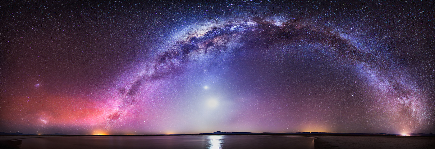
Found on Twitter, via @SciencePorn – One of the most beautiful pictures I’ve ever seen. Star photography by Nicholas Buer pic.twitter.com/RlwvSQNBAy. Much larger view here.
Nicholas Buer works hard to get these shots — a bit of a master, no?
This one was the Astronomy Picture of the Day (APOD) for January 27, 2014 (click that link for a much larger and more glorious view). Much more detail there, revealing that this is much more of the Milky Way than you’d usually see.
From the Northern to the Southern Cross
Image Credit & Copyright: Nicholas Buer Explanation: There is a road that connects the Northern to the Southern Cross but you have to be at the right place and time to see it. The road, as pictured above, is actually the central band of our Milky Way Galaxy; the right place, in this case, is dark Laguna Cejar in Salar de Atacama of Northern Chile; and the right time was in early October, just after sunset. Many sky wonders were captured then, including the bright Moon, inside the Milky Way arch; Venus, just above the Moon; Saturn and Mercury, just below the Moon; the Large and Small Magellanic Clouds satellite galaxies, on the far left; red airglow near the horizon on the image left; and the lights of small towns at several locations across the horizon. One might guess that composing this 30-image panorama would have been a serene experience, but for that one would have required earplugs to ignore the continued brays of wild donkeys.
Save
Spread the word; friends don't allow friends to repeat history.
Leave a Comment » | Astronomy, photography, Travel | Tagged: Astronomy, Astronomy Picture of the Day, Milky Way, Nicholas Buer, photography, Travel | Permalink
Posted by Ed Darrell
March 26, 2014
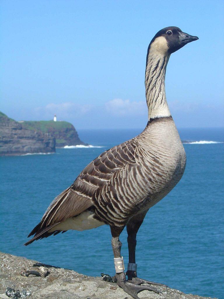
Caption: USFWS Refuge System @USFWSRefuges – Nene hatchings on James Campbell National Wildlife Refuge are first in [Oahu] Hawaii in centuries http://bit.ly/1jBxFrT pic.twitter.com/PK2l9PVa3v (this photo taken on Kaui, at the Kilauea Point National Wildlife Refuge). Photograph by Brenda Zaun/USFWS/Flickr Creative Commons
These
great looking geese, known as Nene, are thought to have descended from Canada geese blown off course; once they were common on many of the Hawaiian Islands, but by 1952 there were only 30 left.
Bones found on Oahu show they once thrived there. A few birds — blown off course again, or looking for more territory? — moved to Oahu a few months ago, and have raised young. Scientists are watching to see how it works out.
With short name featuring only two different letters, “Nene” is a popular crossword answer, and clue. Some ornithologists half-joke that the familiarity among crossword enthusiasts was a huge aid in getting aid for the wild populations of the bird, and in getting the Endangered Species Act passed into law.
More:
Spread the word; friends don't allow friends to repeat history.
2 Comments | Bird Watching, endangered species, Geography - Physical, History, Ornithology, Travel, Wildlife | Tagged: Bird Watching, geography, Hawaii, History, Nene Goose, Ornithology, Travel, Wildlife | Permalink
Posted by Ed Darrell
March 21, 2014
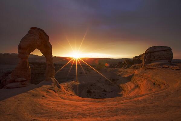
From the U.S. Department of Interior: This stunning photo of dusk @ArchesNPS by Jonathan Backin is the perfect way to end the week. #utah #nature pic.twitter.com/5bIanEG8sZ
Delicate Arch, with a dusting of snow, as the sun sets.
A great reason to live in Moab, Utah, or visit there.
Spread the word; friends don't allow friends to repeat history.
Leave a Comment » | Geography - Physical, geology, National Parks, Travel, Utah | Tagged: Arches National Park, Delicate Arch, Department of Interior, geography, geology, Jonathan Backin, Moab, Photogarphy, Travel, Utah | Permalink
Posted by Ed Darrell
March 19, 2014

From Twitter: “Another e.g. pic to show that school transport in Asia needs attention on health & safety aspects pic.twitter.com/Mn2FbSSELX”
Do you think the students have wi-fi to finish their homework on the way to school?
(This is not necessarily representative of all Indian school buses.)
One wonders at the stories behind such “buses” and their use. It might make an interesting geography assignment, to find out how students get to school in other nations. What is the most exotic, bizarre, dangerous or luxurious ride?
More:
Spread the word; friends don't allow friends to repeat history.
7 Comments | children, Education, India, Safety, Transportation, Travel | Tagged: Bal Mandir, children, Education, India, Safety, School Bus, Transportation, Travel | Permalink
Posted by Ed Darrell
March 18, 2014
Another great shot from America’s public lands:
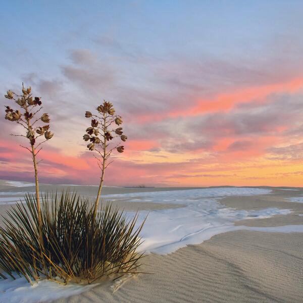
Department of Interior Great American Outdoors Tumblr caption: One of the world’a great natural wonders – the glistening white sands @WhiteSands_NPS. #NewMexico pic.twitter.com/dbzPpIfSRW
One of the problems of touring places like White Sands National Monument is that most tourists arrive mid-day; most spectacular views are probably close to sunrise or sunset, when the sky adds colors other than “bright” to the scene.
Rising from the heart of the Tularosa Basin is one of the world’s great natural wonders – the glistening white sands of New Mexico. Great wave-like dunes of gypsum sand have engulfed 275 square miles of desert, creating the world’s largest gypsum dunefield. White Sands National Monument preserves a major portion of this unique dunefield, along with the plants and animals that live here.
Yes, the same White Sands where the Trinity Project first triggered an atomic weapon, in 1945 — but the blast site is actually about 100 miles north of the National Monument on the military’s White Sands Missile Range. Historical reasons to visit, as well as nature and beauty reasons.
I assume that’s some sort of yucca in the photo; can you tell more specifically?
More, related:
Spread the word; friends don't allow friends to repeat history.
3 Comments | Deserts, Geography - Physical, National Parks, Travel | Tagged: Department of Interior, geography, photography, Travel, White Sands National Monument | Permalink
Posted by Ed Darrell
March 11, 2014
This is a hopeful picture.
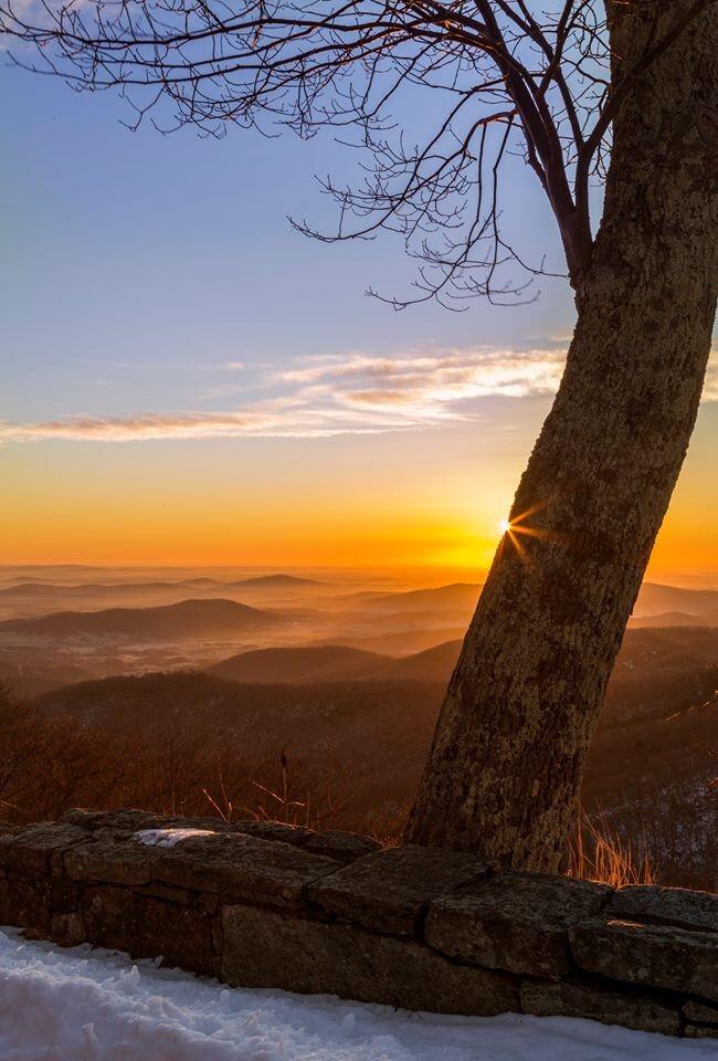
US Dept of Interior Tweet: Beautiful #sunrise over @ShenandoahNPS last weekend. #Virginia #travel #nature pic.twitter.com/T2sEgczGsz
Probably taken along the Blue Ridge Parkway. At the bottom of the photo, note the stone wall, probably built by the Civilian Conservation Corps during the Franklin Roosevelt administration, and still contributing to America’s beauty and economy 80 years later.
I can imagine driving along, catching a beautiful sunrise, but not being at a point to stop to photograph it. Driving farther along, the photographer found a safe place to stop, but the sunrise itself was gone by 15 minutes. With the aid of a young tree, however, the photographer can recapture that moment of the Sun’s peeking over the horizon, without special effects. Nice thought for the shot.
Spread the word; friends don't allow friends to repeat history.
8 Comments | National Parks, photography, Public Lands, Travel | Tagged: Department of Interior, photography, Public Lands, Shenandoah National Park, Travel | Permalink
Posted by Ed Darrell


