Can the scientist appreciate the beauty of creation as much as the non-scientist religious person?
Can you get the joke in this photo, without a smattering of knowledge of geography, and languages? Or am I looking at it wrong?
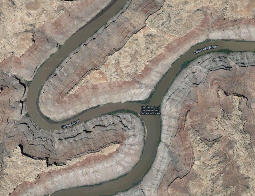
Confluence of the Green and Colorado Rivers, in Canyonlands National Park. Photo by Jim Collins, posted on Facebook by Canyonlands National Park
It’s a joke on a planetary scale, if not a cosmic one.
(Hints: This is a photo looking from the north, I think; “Colorado” means “red” in Spanish.)
Update: Okay, Mr. Higginbotham convinced me. We’re looking from the west, and that’s the Colorado coming from the top of the picture, and the Green coming from the bottom left; then the conjoined streams flow away, to the bottom right. So, in the photo, the Colorado River is, appropriately, red, while the Green River is, fittingly, green
Not a majestic joke by Mother Nature, but a poetic way to remind us of the names of these rivers.
Poetry that might make us smile, too.
(It’s rare that these rivers run such dramatically different colors, especially with the Colorado that red, that far north.)
Google Maps aerial photo of the Confluence of the Green and Colorado Rivers; match the geography with the other photo, and note the labels on this one. Rotate this picture 90 degrees to the left, it matches up better. Tip of the old scrub brush to Mr. J. A. Higginbotham.
Adelie penguins struggle to survive changes in their nesting and feeding sites caused by warming air and waters around Antarctica
New, very short film from the E. O. Wilson Biodiversity Foundation highlights threats to Adelie penguins from climate change, already. Actor and conservation activist Harrison Ford narrated “Ghost Rookeries, Climate Change and the Adelie Penguin.”
Details from the Biodiversity Foundation at their YouTube site:
Published on Jun 26, 2013
“Ghost Rookeries,” narrated by actor, conservationist, and member of the E.O. Wilson Biodiversity Foundation (EOWBF) Board of Advisors Harrison Ford, conveys the story of the Adelie Penguin, whose habitat—and thus the biodiversity of all of Antarctica—is being threatened by real-time environmental changes.
“The consequences of a loss of biodiversity could encompass everything from altering key Antarctic marine food chains to the loss of species that may hold cures to cancer,” writes Dr. James McClintock, whose recent book, ‘Lost Antarctica: Adventures in a Disappearing Land’ (Palgrave/MacMilllan, 2012), forms the basis of “Ghost Rookeries.”
The E.O. Wilson Biodiversity Foundation (EOWBF) and the Association of Zoos and Aquariums (AZA) will be embarking on an exciting new initiative beginning in the summer of 2013. Beginning with “Ghost Rookeries: Climate Change and the Adelie Penguin” (4 minutes, 2013), short videos produced by the EOWBF will be shown at select AZA-accredited zoos and aquariums located in the United States. With the vast reach of AZA-accredited zoos and aquariums, “Ghost Rookeries” and future videos will be seen by millions of visitors.
Dr. Paula Ehrlich, President and CEO of the EOWBF, calls “Ghost Rookeries” and the partnership with AZA “. . . a wonderful way to engage audiences about the importance of preserving our biological heritage through story. The Adelie Penguin is an iconic story, a symbol, of the real-time effect of climate change on biodiversity.”
This film looks at a small part of the Adelie penguin population, on Torgerson Island, near Palmer Station. This population symbolizes the difficulties of dealing with climate change, or even knowing what the effects will be. Critics of pollution control to stop climate change argue that populations of all animals and plants will adapt. Indeed the last decade saw a rise in total numbers of Adelies across Antarctic waters, and Gentoo penguins have set up new colonies to avoid warming air and waters.
More careful watchers note problems, though. Warming air, and decreasing hard ice, brings more snow — nominally good, if one assumes the snow turns to ice. In this case, the snows are brief, and they melt quickly. It’s the cold meltwater that kills the chicks, drowning them. This may be counterintuitive, or even ironic, that warming causes a cold water seabird to drown, or die of hypothermia. Nature is stranger than we can imagine, and often strange enough that it defies the understanding of scientifically-dilettante politicians.
Generally the loss of ice is the biggest problem for penguins; specific populations face entirely different threats, however, depending on the local effects of climate change.
Dr. Jim McClintock, in Antarctica. A professor at the University of Alabama-Birmingham, he wrote Antarctica Lost, upon which the film about the Adelie penguins is based.
The film is a short project based off of the work of Dr. Jim McClintock, an almost-legendary Antarctic researcher based out of the University of Alabama at Birmingham (UAB). McClintock published a book on his work last year that deals with many different aspects of climate change in the Southern Ocean and its continental land mass,Lost Antarctica, Adventures in a Disappearing Land.
(This is not a place to bolster creationist ideas. This is real science, looking at God’s handiwork first hand.)
A North Carolina university makes field trips to Yosemite? I’d love to take that class!
Watching this film, you get a sense of how important it can be to the education of our children to travel in the summers, to take vacations to our National Parks, and to places like Yosemite.
Where are you taking your kids this summer? Kids, where are you going?
Enjoy it. Geology lessons are often fun, and this one, on film, is more fun than most.
As ordered reported by the Senate Committee on Energy and Natural Resources on June 18, 2013.
CBO estimates that enacting this legislation to name a peak in Alaska would have no significant impact on the federal budget and would not affect direct spending or revenues; therefore, pay-as-you-go procedures do not apply. S. 155 contains no intergovernmental or private-sector mandates as defined in the Unfunded Mandates Reform Act and would not affect the budgets of state, local, or tribal governments.
Calling a mountain by its name won’t affect the budget? Good news, I’m sure. Shakespeare was right.
STATEMENT OF PEGGY O’DELL, DEPUTY DIRECTOR FOR OPERATIONS, NATIONAL PARK SERVICE, DEPARTMENT OF THE INTERIOR, BEFORE THE SUBCOMMITTEE ON NATIONAL PARKS OF THE SENATE ENERGY AND NATURAL RESOURCES COMMITTEE, CONCERNING S. 155, TO DESIGNATE A MOUNTAIN IN THE STATE OF ALASKA AS DENALI.
April 23, 2013
Mr. Chairman, thank you for the opportunity to present the Department of the Interior’s views on S. 155, a bill to designate a mountain in the State of Alaska as Denali.
The National Park Service appreciates the long history and public interest for both the name Mount McKinley and the traditional Athabascan name, Denali. The Department respects the choice made by this legislation, and does not object to S. 155.
Located in what is now Denali National Park and Preserve, the highest peak in North America has been known by many names. The National Park Service’s administrative history of the park notes that, “The Koyukon called it Deenaalee, the Lower Tanana named it Deenaadheet or Deennadhee, the Dena’ina called it Dghelay Ka’a, and at least six other Native groups had their own names for it.
“In the late 18th century various Europeans came calling, and virtually everyone who passed by was moved to comment on it. The Russians called it Bulshaia or Tenada, and though explorers from other nations were less specific, even the most hard-bitten adventurers were in awe of its height and majesty.
“No American gave it a name until Densmore’s Mountain appeared in the late 1880s, and the name that eventually stuck—Mount McKinley—was not applied until the waning days of the nineteenth century,” a gesture of support to then-President William McKinley.
In 1975, the State of Alaska officially recognized Denali as the name of the peak, and requested action by the U.S. Board on Geographic Names to do the same.
In 1980, Congress changed the name of Mount McKinley National Park to Denali National Park and Preserve (P.L. 96-487, Section 202), but did not act on the name change for the mountain.
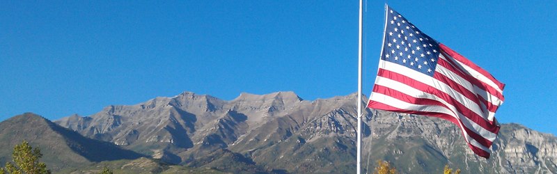
Mt. Timpanogos and the U.S. flag. Photo by Bob Walker of Orem, Utah; from Orem, circa September 2012. That’s Mt. Baldy on the left. This site is about six miles from our old home in Pleasant Grove, Utah.
Mount Everest North Face as seen from the path to the base camp, Tibet. Wikipedia image
A pick from the staff at Vimeo.
It’s astonishing how many people ascend Mt. Everest in our time. Look at the tent city.
Everest’s beauty is stunning, always has been, but is now revealed by high-definition image capture unavailable just 10 years ago, now distributed by the internet.
These photos are mostly from about 25,000 feet in elevation — about where much domestic U.S. air travel occurs. The weather up there is spectacular, if you’re not in it. It’s spectactular if you’re in it, too — but I’m viewing it from Dallas, where we’re above 90 degrees in the day, now, just 800 feet above sea level.
One of the most rewarding parts of the journey was being able to share it with thousands of students on epals.com/everest
This time lapse video is comprised of thousands of photographs, processed and assembled on Mt. Everest.
Shot on a Canon 5D Mark II
-Canon 2.8 16-35mm
-Canon 2.8 24-70mm
-Canon 2.8 70-200mm (which was way to heavy to carry beyond 6400M)
-TL Remote was purchased off eBay
Edited in Final Cut Pro
Processed in Adobe LightRoom
Movies compiled in Quicktime
Feynman and the famous C-clamp experiment — in a glass of ice water — demonstrating how rubber O-rings failed in launch, at the Challenger Commission. (Why are there so few good photos of this event?)
Geography and history teachers, you should watch this on the day after Feynman Day. Can you make use of this in your classes — say, after the state tests?
How about you physics and science teachers?
Tuvan People’s Republic, marked in green. Wikipedia image
In 1998 NOVA produced and broadcast a film that rather defies categorization. Biography? Drama? Humor? Frustrated travelogue?
“Last Journey of a Genius” tells a lot of biography of Dick Feynman, but it focuses on his unusual drive to learn about, and travel to an obscure Central Asian country/province/area/culture called Tannu Tuva. Feynman’s close friend Ralph Leighton plays a big role in this film, too. This film reveals more about the character of Richard Feynman, his overwhelming curiosity and humanity, than you can get any other place, including his memoirs (which every civil human should read).
NOVA captivates me almost every week. Good fortune found me in front of a television somewhere when this was first broadcast. For several reasons, I’ve been unable to get a VHS, or a DVD version of the story despite many attempts over the years.
But fortune and good history smile again. Open Culture collected the film, and it’s available for free in their documentary section.
Drumming, story telling, geography, Cold War politics, ballet, more drumming, some nuclear physics, astronomy, a lot of good humor, and a plea for orange juice. It still makes me smile.
In 1989, PBS’ NOVA aired The Last Journey of a Genius, a television film that documents the final days of the great physicist Richard Feynman and his obsession with traveling to Tannu Tuva, a state outside of outer Mongolia, which then remained under Soviet control. For the better part of a decade, Feynman and his friend Ralph Leighton schemed to make their way to Tannu Tuva, but Cold War politics always frustrated their efforts. The video runs roughly 50 minutes and features an ailing Feynman talking about his wanderlust and their maneuverings. He died two weeks later, having never made the trip, though Ralph Leighton and Feyman’s daughter Michelle later landed in their Shangri-La. Her journey was recorded by the Russian service of the BBC.
The film now appears in the Documentary section of our collection of Free Movies Online.
Hang on to this link for Feynman Day 2014 (May 11). What’s your favorite Feynman story?
This kind of history and science is exactly the sort of stuff CSCOPE critics in Texas, and critics of the Common Core standards, worry that children will see. Very odd, because stuff this good is not even mentioned in CSCOPE, nor in CCSS.
Tip of the old scrub brush to Kenny Darrell, who found this film and let me know about it.
L. Banks illustrated a publication about an ancient bowl found at the Burnt City, in what is now Iran.
It’s a nice rendering of . . . gee, what is that?
If you remember correctly, it’s a goat. It’s a goat.
More specifically, it’s the goat depicted on “the world’s oldest animation,” a bowl more than 5,000 years old that some researchers think may have been the earliest attempt to depict animals in motion.
I wrote about the bowl back in 2008. I learned of it from Kris Hirst at About.com, and I thought it was interesting. “Animation” in the headline, at spring break, and tens of thousands of kids took a look at the little .gif animation from photos of the bowl. The post took about ten minutes to compose, and it remains the single most popular post ever at Millard Fillmore’s Bathtub (even more popular than the posts about the imaginary Texas chainsaw massacre).
So I stumbled on Banks’s drawing. Illustration is often high art — the image above is identified as an educational image. Children’s book? Don’t know.
Banks has some other very nice illustrations on display, on completely different subjects. You should go see.
What was that bowl maker trying to show with the goat and tree on that bowl? Did s/he dream that people would be making images inspired by the bowl, 52 centuries later?
An animated .gif made from photographic images of a bowl found at the Burnt City, and dated at 5,200 years.
Spread the word; friends don't allow friends to repeat history.
Our goldfinches left several weeks ago. The cedar waxwings came through in at least three big waves, starting in February (and the last just over a week ago). House finches moulted, and the breeding males have bright red heads. Migrating robins left us by the end of January, but a lot more residents stayed with us.
We have at least one, and maybe three cardinal families. A black-capped chickadee family stuck around. Haven’t seen a titmouse in a month, but I think they’re still in the neighborhood. The black-chinned hummingbird family is back, and maybe a few other hummers. The resident blue jays and white-winged doves duke it out every day. Carolina wren stayed, and may have already fledged; but there are too many wrens for one family — is that a Bewick’s wren?
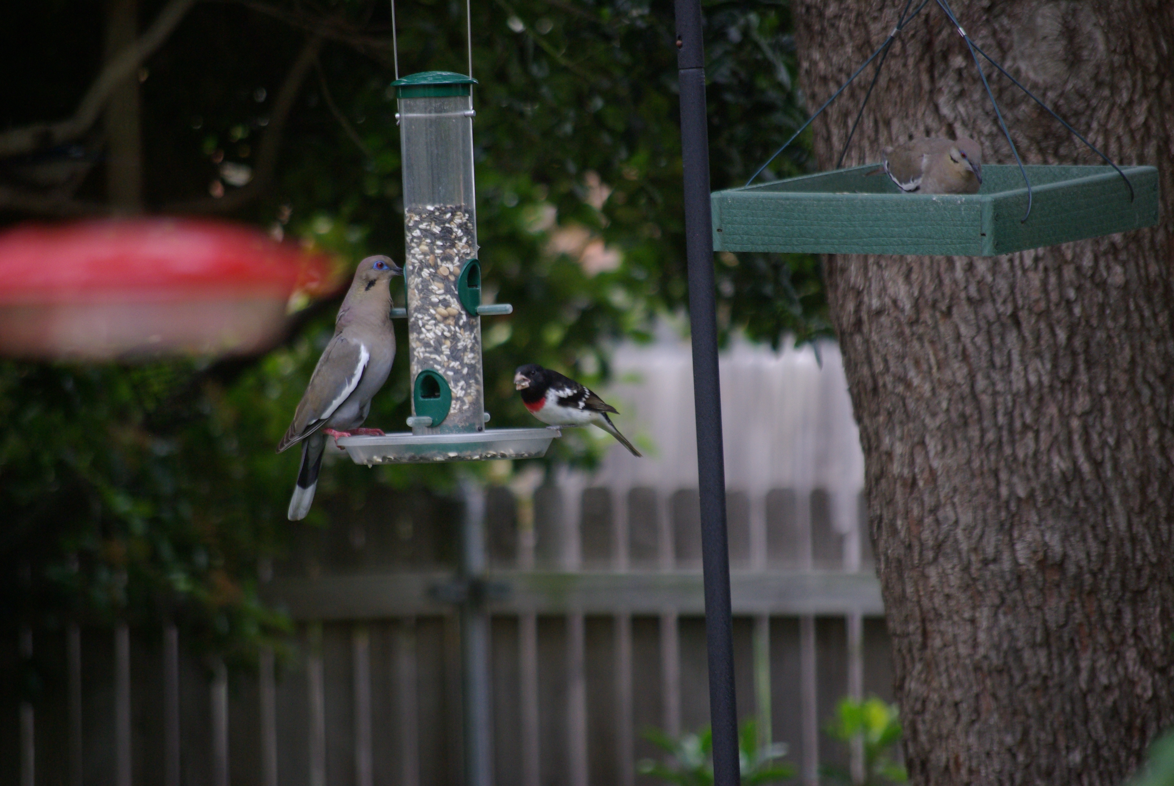
What’s THAT?
White-winged dove, left, can’t scare away the rose-breasted grosbeak from the songbird feeder. Photo by Ed Darrell
Look closer. Photo by Ed Darrell
It’s a rose-breasted grosbeak, Pheucticus ludovicianus. It seems late for migrating birds, but only because so many migratory species migrate earlier these days.
Haunts of the rose-breasted grosbeak, from Cornell University’s ornithological laboratory.
Would love to have a grosbeak family, but the Cornell ornithologists say this is fly-through territory. Maybe that explains why it won’t scare by the white-winged dove,Zenaida asiatica. Dallas is the western edge of the grosbeaks’ migratory path, but the eastern edge of the dove’s territory. They probably don’t see much of each other.
See this United Nations Development Program ten-minute video that, to the wise and concerned, lays out the stakes of delaying action against human-caused climate change.
Without enough funding, NGOs work to help farmers getting hammered in the Southern Philippines, and other places.
In the Southern Philippines, farmers’ lives and the weather are intimately interwoven, but something is changing, now that the rains in Agusan del Norte are too heavy, the sun shines too fiercely. Now there’s hope for poor farmers with the community-based approach monitoring and Weather Index-Based Insurance packages, to warn people when heavy weather is on the way.
Though, I do weary of the astonishing abuse of acronyms in this work-of-the-angels. “WIBI?”
Incidentally, though the phrase doesn’t appear anywhere in this material, this is exactly the sort of work carried on by the UN’s Agenda 21 project. Doesn’t look subversive to me.
Tip of the old scrub brush to the UNDP and ILO Tweet:
More Iceland than Aurora. Not necessarily bad. Great timelapse photos.
You have my permission to turn down the music volume.
Filmmaker Anna Possberg wrote:
Iceland has become a popular destination since the singer Björk made her island famous by her songs. Yet few people know Iceland during wintertime. And I am sure that they miss a beautiful part of the island: the snow covered rocks, the magic arctic light and especially the phantastic aurora borealis dancing in the sky. The days spent at the Jokülsarlon glacial lake were one of the most beautiful and peaceful Christmas time I remember.
Jökulsárlón, a glacial lake in Iceland. To the right, the mouth of the glacier Vatnajökull. Wikipedia photo
Loren Holmes photograph straight up of Aurora borealis over Eureka, Alaska, on March 13, 2013. AlaskaDispatch.com
I love fireworks. Kathryn and I have been known to drive a couple hundred miles to see a good show. Fireworks in honor of the guy who gave us the Constitution and the First Amendment (and much more), seems a great idea to me.
But no one did it . . .
Sometimes the Sun, Moon, stars and planets conspire.
Here’s one of the best, most inspiring five minutes you’ll spend this week. Look what the Sun sent us, filmed in time-lapse glory above Eureka, Alaska, on March 16, 2013, the anniversary of James Madison’s birthday; from AlaskaDispatch.com:
A timelapse of the Aurora Borealis, Northern Lights, over Eureka, Alaska on March 16, 2013. Taken with a Canon 5D Mark III and 24mm f/1.4 and 70-200 f/2.8 lenses. Compiled from 3800 images, with exposures between 2 seconds and 30 seconds.
One of the most southerly populations of polar bears in the world – and the best studied – is struggling to cope with climate-induced changes to sea ice, new research reveals. Based on over 10 years’ data the study, published in the British Ecological Society‘s Journal of Animal Ecology, sheds new light on how sea ice conditions drive polar bears’ annual migration on and off the ice.
Led by Dr. Seth Cherry of the University of Alberta, the team studied polar bears in western Hudson Bay, where sea ice melts completely each summer and typically re-freezes from late November to early December. “This poses an interesting challenge for a species that has evolved as a highly efficient predator of ice-associated seals,” he explains. “Because although polar bears are excellent swimmers compared with other bear species, they use the sea ice to travel, hunt, mate and rest.”
Caption from EurekAlert: An adult female polar bear wearing a GPS-satellite linked collar with her two 10-month-old cubs waits for the sea ice to re-form onshore in western Hudson Bay, Manitoba, Canada. Photo Copyright Andrew Derocher, Univeristy of Alberta.
Polar bears have adapted to the annual loss of sea ice by migrating onto land each summer. While there, they cannot hunt seals and must rely on fat reserves to see them through until the ice returns.
Dr. Cherry and colleagues wanted to discover how earlier thawing and later freezing of sea ice affects the bears’ migration. “At first glance, sea ice may look like a barren, uniform environment, but in reality, it’s remarkably complex and polar bears manage to cope, and even thrive, in a habitat that moves beneath their feet and even disappears for part of the year. This is an extraordinary biological feat and biologist still don’t fully understand it,” he says.
From 1991-97 and 2004-09, they monitored movements of 109 female polar bears fitted with satellite tracking collars. They tagged only females because males’ necks are wider than their heads, so they cannot wear a collar. During the same period, the team also monitored the position and concentration of sea ice using satellite images.
“Defining precisely what aspects of sea ice break-up and freeze-up affect polar bear migration, and when these conditions occur, is a vital part of monitoring how potential climate-induced changes to sea ice freeze-thaw cycles may affect the bears,” he says.
The results reveal the timing of polar bears’ migration can be predicted by how fast the sea ice melts and freezes, and by when specific sea ice concentrations occur within a given area of Hudson Bay.
According to Dr. Cherry: “The data suggest that in recent years, polar bears are arriving on shore earlier in the summer and leaving later in the autumn. These are precisely the kind of changes one would expect to see as a result of a warming climate and may help explain some other studies that are showing declines in body condition and cub production.”
Recent estimates put the western Hudson Bay polar bear population at around 900 individuals. The population has declined since the 1990s, as has the bears’ body condition and the number of cubs surviving to adulthood.
Caption from EurekAlert: This is a subadult polar bear on a lake on the shores of Hudson Bay in Manitoba, Canada in November waiting for the sea ice to re-form. Copyright Andrew Derocher, Univeristy of Alberta.
Because polar bears’ main food source is seals, and these are hunted almost exclusively on sea ice, the longer bears spend on land, the longer they must go without energy-rich seals. “Climate-induced changes that cause sea ice to melt earlier, form later, or both, likely affect the overall health of polar bears in the area. Ultimately, for polar bears, it’s survival of the fattest,” says Dr. Cherry.
He hopes the results will enable other scientists and wildlife managers to predict how potential climate-induced changes to sea ice freeze-thaw cycles will affect the ecology, particularly the migration patterns, of this iconic species.
###
Seth Cherry et al (2013). ‘Migration phenology and seasonal fidelity of an Arctic marine predator in relation to sea ice dynamics’, doi: 10.1111/1365-2656.12050, is published in the Journal of Animal Ecology on Wednesday 20 March 2013.
Starving polar bears. (loe.org) (This site has a good, but very sad, interview with Dr. Derocher; it also links to an audio of the Living On Earth radio program from which the interview is excerpted.)
I shot this film over 4 trips to NYC 2011-2012. The time-lapse sequences you see here were made (mostly) from hundreds of thousands of still images. A Canon 7D and T3i were the main cameras, with backup from a couple of older Nikon Coolpix 5000 point and shooters. A few clips are sped-up video.
Many thanks to the generosity of the musician/composer who allowed his great celtic track “Sawjig” to be used;
Ben Rusch aka Jasmine Brunch benrusch.com jasminebrunch.com
Or, until that account is unsuspended by the forces supporting Donald Trump: Follow @FillmoreWhite, the account of the Millard Fillmore White House Library
We've been soaking in the Bathtub for several months, long enough that some of the links we've used have gone to the Great Internet in the Sky.
If you find a dead link, please leave a comment to that post, and tell us what link has expired.
Thanks!
Retired teacher of law, economics, history, AP government, psychology and science. Former speechwriter, press guy and legislative aide in U.S. Senate. Former Department of Education. Former airline real estate, telecom towers, Big 6 (that old!) consultant. Lab and field research in air pollution control.
My blog, Millard Fillmore's Bathtub, is a continuing experiment to test how to use blogs to improve and speed up learning processes for students, perhaps by making some of the courses actually interesting. It is a blog for teachers, to see if we can use blogs. It is for people interested in social studies and social studies education, to see if we can learn to get it right. It's a blog for science fans, to promote good science and good science policy. It's a blog for people interested in good government and how to achieve it.
BS in Mass Communication, University of Utah
Graduate study in Rhetoric and Speech Communication, University of Arizona
JD from the National Law Center, George Washington University


 Posted by Ed Darrell