Lack of hard ice platforms, pack ice, means mother polar bears can’t hunt to feed their cubs. While an adult polar bear can swim a distance to find ice, the cubs can’t. And if the adult doesn’t find hard ice, they perish. Long swims are deadly to cubs.
It’s a cute pic, and we hope momma bear is swimming to an ice platform and can feed that cute little cub so it grows and flourishes.
We know the odds are against it.
Spread the word; friends don't allow friends to repeat history.
Of course it was a cartoonist. Where else does one go to find the truth these days, but the cartoons?
XKCD dramatically shows differences in North American cities and their relationship with their local ice sheets, 21,000 years ago. Cartoon by Randall Munroe.
Twenty kilometres in 20 years. That’s how much the Ilulissat glacier has retreated as this mighty, flowing river of ice crumbles into the ocean. It sounds like a lot. But I did not fully realize what this meant until we flew over the Ilulissat icefjord. It takes 10 minutes for the helicopter to fly over the amount of ice that has been lost because of global warming – in this glacier alone.
The speed at which the glacier moves has doubled relative to that in 1998. My scientist brain, accustomed to working with numbers and large scales, had a hard time absorbing this information. If I was rationally aware of the consequences of global warming from scientific reports before, now I felt it emotionally. This is what my trip to Greenland with a group of World Economic Forum Young Global Leaders did to us. It made us move from knowing and caring to be desperate to do something about it.
The experience also made us realize that all the international negotiations and agreements to date are not going to help avert the imminent catastrophe. Not even the boldest targets to reduce carbon pollution put forward by the smartest nations are going to move the dial. It’s all an illusion of movement, kind of like Alice in Wonderland’s Red Queen, running and running but not going anywhere.
Truth on ice.
There is a difference, though. Ice thins, gets weaker, and covers less area. As that happens, as the planet warms, the density of denialists does not appear to decrease, at least not fast, and not toward greater understanding and less insanity.
Spread the word; friends don't allow friends to repeat history.
Much as the GOP Caucus and other climate-change deniers, Roman officials in Pompeii and Herculaneum refused to be alarmed at the ground shaking, and obvious eruptions from Mount Vesuvius, on August 24, 79 C.E.
At noon on August 24, 79 AD, Mount Vesuvius erupted and buried the cities of Pompeii and Herculaneum. pic.twitter.com/ooYjzpDfS8
Milton Glaser is famous for uniting New Yorkers under the simple, iconic “I Heart New York” logo. (He also designed the label for Brooklyn Brewery and, as I learned on a recent tour, had the good sense to emphasize the beer’s borough of origin back before it was cool.) Now, at age 85, he’s out to rebrand the climate movement. The pitch: a hazy black circle with just a small band of green (read: Earth), which people can purchase and wear as a button. In a poster hung on the exterior of the New York School of Visual Arts‘ East 23rd Street building, the logo is accompanied by the slogan “It’s not warming, it’s dying.”
The obvious problem, right off the bat, is that Earth is warming: It’s done so rapidly over the 20th century, and is expected to continue at an even faster rate over the next 100 years. The world’s governments agreed that we should try to limit warming to below 2 degrees Celsius (3.6 degrees Fahrenheit) above pre-industrial levels to try to avoid the worst consequences of that warming, yet we’re on track to blow right past that limit. While Glaser obviously agrees that this is a problem, the slogan obscures that point. And as someone attuned to the world of climate deniers, I can’t help thinking that getting the hashtag #itsnotwarming to go viral might not have the intended effect.
But those are technicalities. Glaser told WNYC’s Brain Lehrer that his problem with the word “warming” is that it “sounds reassuring and comforting.” So if your complaint is that the slogan sounds overly pessimistic, well, that’s kind of the point. “Either Earth is dying or it’s beginning to grow again,” Glaser explained. “My preference would be that it was beginning to grow again, but for the moment I have no evidence of that.”
EPA Finalizes Greenhouse Gas Permit for Voestalpine Iron Production Plant $740M facility in San Patricio Co., TX, will bring 1,400 construction jobs and150 permanent jobs
DALLAS – (June 16, 2014) The U.S. Environmental Protection Agency (EPA) has issued a final greenhouse gas (GHG) Prevention of Significant Deterioration (PSD) construction permit to Voestalpine for an iron production plant in San Patricio County, TX. The facility’s process for producing iron will use minimal natural gas and will be 40 percent more efficient than traditional methods. The permit is another in the series of permits drafted by the Texas Commission on Environmental Quality (TCEQ) and issued by EPA under a program to facilitate timely permitting for applicants in the State of Texas.
“Voestalpine shows energy efficiency is a common-sense strategy for success, not just in business but for the environment as well,” said Regional Administrator Ron Curry. “The joint EPA and TCEQ permitting program is helping Texas business grow while building greener plants.”
The plant will reduce iron ore pellets, which will be used as raw material input at steel mills. The direct reduced iron process will use only clean-burning natural gas instead of solid fossil fuels. The estimated project cost is $740 million and will bring 1,400 construction jobs to the area. Once complete, the facility will create around 150 permanent jobs.
In June 2010, EPA finalized national GHG regulations, which specify that beginning on January 2, 2011, projects that increase GHG emissions substantially will require an air permit.
EPA believes states are best equipped to run GHG air permitting programs. Texas is working to replace a federal implementation plan with its own state program, which will eliminate the need for businesses to seek air permits from EPA. This action will increase efficiency and allow for industry to continue to grow in Texas.
EPA has finalized 43 GHG permits in Texas, proposed an additional six permits, and currently has 21 additional GHG permit applications under review and permit development in Texas.
Headquarters of Voestalpine, head-turning building by Dietmar Feichtinger Architectes, located in Linz, Austria. Architecture News Plus image. Voestalpine plans to build a $740 million steel plant near Corpus Christi, Texas.
This is big news, really. Texas constantly complains about regulations on greenhouse gases, and regularly and constantly sues EPA to stop regulation. Texas and it’s wacky governor Rick Perry constantly complain that EPA regulation harms jobs, and that permits never really get issued. So this announcement should be front page news in most Texas newspapers.
That’s it for Texas media. Where are the Dallas Morning News, the Fort Worth Star-Telegram, the Houston Chronicle, the San Antonio Express, the El Paso Times? Big market TV and radio?
National coverage was limited to low-circulation newsletters.
Caption from Voestalpine LLC: After about a year of preparation, Wolfgang Eder, CEO of voestalpine, broke ground today for the construction of a direct reduction plant in Texas (USA). This EUR 550 million investment is the largest foreign investment in the history of the Austrian Group. The voestalpine Texas LLC plant is being constructed at the La Quinta Trade Gateway Terminal in close proximity to the City of Corpus Christi. Starting in 2016, the plant will produce two million tons of HBI (Hot Briquetted Iron) and DRI (Direct Reduced Iron) annually and will supply Austrian locations, such as Linz and Donawitz, with “sponge iron” as a premium raw material. With the new facility, voestalpine can significantly reduce production costs in Europe. The highly automated plant will create 150 jobs.
Spread the word; friends don't allow friends to repeat history.
Drought in the West, Central and Southern Plains, and Midwest. Long- and short-term dryness will increase wildfire risk and continue to have impacts on water resources and agriculture.
El Niño development likely this summer or autumn. According to NOAA’s Climate Prediction Center, there is a greater than 65 percent chance of El Niño conditions developing later this year, which could have significant impacts on temperature and precipitation patterns across the U.S. More information is available from the Climate Prediction Center.
The average temperature for the contiguous U.S. during April was 51.7°F, which was 0.7°F above the 20th century average. This was the 46th warmest April in the 120-year period of record.
Much of the contiguous U.S. had April temperatures near the 20th century average. Above-average temperatures were scattered along the West Coast and in the Southwest, the Southern Plains, and across parts of the Ohio Valley and the Southeast. Below-average temperatures were observed across parts of the Upper Midwest and Northern Plains. No state had April temperatures among their 10 warmest or coolest.
Alaska had the 12th warmest April of its 96-year period of record, with a temperature 3.8°F above the 1971-2000 average. This was the warmest April for Alaska since 2007. Much of the warmth was situated in western Alaska, where Nome had its fourth warmest April since local records began in 1907. The April precipitation total in Alaska was 23.3 percent below the 1971-2000 average, the 23rd driest April on record. Anchorage had its fifth driest April with only nine percent of normal monthly precipitation.
The April contiguous U.S. precipitation total of 2.83 inches was 0.31 inch above the 20th century average and the 30th wettest April on record.
Above-average precipitation in the Upper Midwest resulted in Wisconsin having its third wettest April and Minnesota its eighth wettest. Heavy precipitation across the Southeast, particularly near the end of the month, caused Alabama to have its fifth wettest April, Georgia its seventh wettest, and Florida its ninth wettest.
On April 29th and 30th, torrential rain fell across the Southeast, Mid-Atlantic and Northeast causing significant flash flooding. The Gulf Coast of Alabama and the Florida panhandle bore the brunt of the heavy rains. At the Pensacola Regional Airport, in Florida, the two-day precipitation total was 20.47 inches, with 15.55 inches of the total falling on the 29th, breaking both one-day and two-day precipitation records; local records date back to 1879. On the 29th, Mobile, Alabama received 11.24 inches of rain, the third greatest calendar day rainfall total for the city since local records began in 1871. According to the 2014 National Climate Assessment released on May 6th, the amount of heavy precipitation falling in single events has increased by 27 percent across the Southeast since 1958. This event is consistent with projections of increases in the frequency and intensity of extreme precipitation events across the U.S. as the world warms.
Below-average precipitation was observed across parts of the West, the central Rockies, and the Central and Southern Plains. Oklahoma had its 12th driest April on record, with 50 percent of average precipitation. Parts of Texas were also particularly dry, where San Angelo observed just 30 percent of normal monthly precipitation.
According to the April 29thU.S. Drought Monitor report, 38.4 percent of the contiguous U.S. was in drought, nearly the same as the beginning of April, with both improvement and degradation of drought conditions on regional scales. Beneficial rain improved drought conditions across the Upper Midwest and Southeast during the month, while drought conditions worsened in parts of the West and across portions of the Central and Southern Plains.
Drought conditions improved in Hawaii during April due in part to heavy rainfall at the end of March and the beginning of April. Only 0.7 percent of the state was experiencing drought conditions on April 29th, down from 14.4 percent at the beginning of the month. This was the smallest drought footprint for Hawaii since April 2008, and the first time since June 2008 that no part of the state was experiencing severe drought. Most of the drought improvement occurred across the Big Island, with central Molokai still experiencing moderate drought conditions.
A severe weather outbreak on April 27-29 spawned at least 38 tornadoes from Nebraska to North Carolina, according to preliminary estimates from NOAA’s Storm Prediction Center. At least 32 fatalities were blamed on the tornadoes, with Arkansas and Mississippi being the hardest hit. An EF-4 tornado in Pulaski and White counties in Arkansas resulted in 15 fatalities, while an EF-4 in Winston County, Mississippi resulted in nine fatalities.
During April, there were about 75 percent more cold daily temperature records (1,419 cold maximum temperature records, 1,380 cold minimum temperature records; 2,799 total) than warm daily temperature records (544 warm maximum temperature records, 1,039 warm minimum temperature records; 1,583 total).
For the first four months of 2014, the contiguous U.S. temperature was 38.7°F, 0.4°F below the 20th century average, and the 46th coldest January-April on record. This was the coldest four-month start to a year since 1993.
Below-average temperatures were widespread across the eastern U.S. where 13 states had January-April temperatures among their 10 coldest on record. The coldest departures from average occurred across the Midwest. No state had its coldest January-April on record.
Warm conditions were observed across a large portion of the West. Arizona and California were both record warm, with four-month temperatures 4.5°F and 5.2°F above their 20th century average, respectively. Nevada, Oregon and Utah each had one of their five warmest January-April periods on record.
The year-to-date precipitation total for the contiguous U.S. was 8.79 inches, 0.68 inch above the 20th century average and the 33rd driest January-April on record.
Below-average four-month precipitation totals were widespread across the Southwest and the Central and Southern Plains. Arizona, Kansas, New Mexico, Oklahoma, and Texas each had January-April precipitation totals that ranked among their 10 driest on record. Oklahoma had its second driest January-April on record, with less than half of average precipitation; 1936 was the driest. The dry conditions across Oklahoma decimated much of the winter wheat crop in the state, with estimates of the lowest harvested yield since 1957. In west Texas, precipitation deficits that date back to 2010 have been unprecedented in the observational record, with nearly every major reservoir in the region at less than 40 percent of capacity.
The U.S. Climate Extremes Index (USCEI) for the year-to-date was the 14th highest on record for the period at 145 percent of average. Elements that contributed to the above-average USCEI included the spatial extent of cold maximum and minimum temperatures, warm maximum temperatures and the spatial extent of drought. The USCEI is an index that tracks extremes (falling in the upper or lower 10 percent of the record) in temperature, precipitation and drought across the contiguous U.S.
Based on REDTI, the contiguous U.S. temperature-related energy demand during January-April was 27 percent above average and the 29th highest in the 1895-2014 period of record.
Department of Interior’s video this week leads with climate change — and in fact, each segment deals with climate change in some way.
Published on May 9, 2014
This week: the White House releases the third annual National Climate Assessment, showing that climate change is already affecting Americans and the U.S. economy; USGS releases a Climate Change Viewer that can track water resource changes at the county, state, and watershed level; Secretary Jewell joins California leaders and first responders as the state braces for another tough wildfire season; the Secretary meets with community leaders and experts to talk about the balance between conservation and smart development; the Secretary announces the approval of a new solar energy project on tribal lands in Nevada, and attends the 69th Departmental Honor Awards Convocation in Washington, DC.
Spread the word; friends don't allow friends to repeat history.
Will it work this time? Can it recharge the effort Al Gore started?
Monte Best of Plainview, Texas, explains to Don Cheadle how the Texas drought caused the Cargill Company to close its meat packing plant in the city. “Act of God,” many local people say.
Here’s the trailer:
The avid promotional explanation:
Published on Mar 14, 2014
Don’t miss the documentary series premiere of Years of Living Dangerously, Sunday, April 13th at 10PM ET/PT.
It’s the biggest story of our time. Hollywood’s brightest stars and today’s most respected journalists explore the issues of climate change and bring you intimate accounts of triumph and tragedy. YEARS OF LIVING DANGEROUSLY takes you directly to the heart of the matter in this awe-inspiring and cinematic documentary series event from Executive Producers James Cameron, Jerry Weintraub and Arnold Schwarzenegger.
Gapminder quiz on global development: “About the Quiz/Teacher’s guide Use this quiz to introduce subjects such as global health, the effects of HIV, population growth and carbon dioxide emissions, or as starting point to discuss what development is. What do the indicators in these quizzes say about the world?”
Spread the word; friends don't allow friends to repeat history.
The world might not be as bad as you might believe!
Don’t Panic – is a one-hour long documentary produced by Wingspan Productions and broadcasted on BBC on the 7th of November 2013.
The visualizations are based on original graphics and stories by Gapminder and the underlaying data-sources are listed here.
Hans’s — “All time favorite graph”, is an animating bubble chart which you can interact with online here and download offline here.
Hans presents some results from our UK Ignorance Survey described here.
Last month was one of the warmest Januaries ever. No, really
And so it was.
Caption from AGU Blog: This is why the global temperature is not taken in your backyard in January. When you average the entire globe for an entire year, a much different picture emerges. NASA Aqua satellite image of a cold and snowy Mid-Atlantic Wednesday morning.
The combined average temperature over global land and ocean surfaces for January was the warmest since 2007 and the fourth warmest on record at 12.7°C (54.8°F), or 0.65°C (1.17°F) above the 20th century average of 12.0°C (53.6°F). The margin of error associated with this temperature is ± 0.08°C (± 0.14°F).
The global land temperature was the highest since 2007 and the fourth highest on record for January, at 1.17°C (2.11°F) above the 20th century average of 2.8°C (37.0°F). The margin of error is ± 0.18°C (± 0.32°F).
For the ocean, the January global sea surface temperature was 0.46°C (0.83°F) above the 20th century average of 15.8°C (60.5°F), the highest since 2010 and seventh highest on record for January. The margin of error is ± 0.04°C (± 0.07°F).
Introduction:
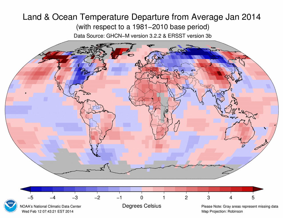
Temperature anomalies and percentiles are shown on the gridded maps below. The anomaly map on the left is a product of a merged land surface temperature (Global Historical Climatology Network, GHCN) and sea surface temperature (ERSST.v3b) anomaly analysis developed by Smith et al. (2008). Temperature anomalies for land and ocean are analyzed separately and then merged to form the global analysis. For more information, please visit NCDC’s Global Surface Temperature Anomalies page. The January 2014 Global State of the Climate report includes percentile maps that complement the information provided by the anomaly maps. These maps on the right provide additional information by placing the temperature anomaly observed for a specific place and time period into historical perspective, showing how the most current month, season, or year-to-date compares with the past.
Temperatures:
In the atmosphere, 500-millibar height pressure anomalies correlate well with temperatures at the Earth’s surface. The average position of the upper-level ridges of high pressure and troughs of low pressure—depicted by positive and negative 500-millibar height anomalies on the January 2014 map—is generally reflected by areas of positive and negative temperature anomalies at the surface, respectively.
January 2014 Blended Land and Sea Surface Temperature Anomalies in degrees Celsius
January 2014 Blended Land and Sea Surface Temperature Percentiles
The combined global land and ocean average temperature during January 2014 was 0.65°C (1.17°F) above the 20th century average. This was the warmest January since 2007 and the fourth highest since records began in 1880. This marks the ninth consecutive month (since May 2013) with a global monthly temperature among the 10 highest for its respective month. The Northern Hemisphere land and ocean surface temperature during January 2014 was also the warmest since 2007 and the fourth warmest since records began in 1880 at 0.75°C (1.35°F) above average. The Southern Hemisphere January 2014 temperature departure of +0.55°C (+0.99°F) was the warmest since 2010 and the fourth warmest January on record.
During January 2014, most of the world’s land areas experienced warmer-than-average temperatures, with the most notable departures from the 1981–2010 average across Alaska, western Canada, Greenland, Mongolia, southern Russia, and northern China, where the departure from average was +3°C (+5.4°F) or greater. Meanwhile, parts of southeastern Brazil and central and southern Africa experienced record warmth with temperature departures between 0.5°C to 1.5°C above the 1981–2010 average, contributing to the highest January Southern Hemisphere land temperature departure on record at 1.13°C (2.03°F) above the 20th century average. This was also the warmest month for the Southern Hemisphere land since September 2013 when temperatures were 1.23°C (2.21°F) above the 20th century average. Some locations across the globe experienced departures that were below the 1981–2010 average. These areas include the eastern half of the contiguous U.S., central Canada, and most of Scandinavia and Russia. The most notable cold anomalies were in Russia, where in some areas the departure from average was 5°C (9°F) below average. Overall, the Northern Hemisphere land surface temperature was 1.17°C (2.11°F) above average—the warmest January since 2007 and the fourth warmest since records began in 1880.
Select national information is highlighted below. (Please note that different countries report anomalies with respect to different base periods. The information provided here is based directly upon these data):
France’s nationally-averaged January 2014 temperature was 2.7°C (4.9°F) above the 1981–2010 average, tying with 1988 and 1936 as the warmest January on record.
Spain experienced its warmest January since 1996 and the third warmest since national records began in 1961, with a temperature of 9°C (48.2°F) or 2°C (3.6°F) above the 1971–2000 average.
The January temperature in Switzerland was 2.4°C (4.3°F) above the 1981–2010 average—the fifth warmest January since national records began 150 years ago.
Austria experienced its fifth warmest January since national records began in 1768. The nationally-averaged temperature was 3.3°C (5.9°F) above the 1981–2010 average. However, in some regions across the southern parts of the country, the temperatures were the highest on record. In Klagenfurt, the temperature departure was 5°C (9°F)—the highest since January 1813.
China, as a whole, recorded an average temperature of -3.4°C (25.9°F) or 1.6°C (2.9°F) above average during January 2014. This was the second highest January value, behind 2002, since national records began in 1961.
In Argentina, persistence of extremely high temperatures across central and northern parts of the country resulted in several locations setting new maximum, minimum, and mean temperature records for the month of January.
Warm temperatures engulfed much of Australia during January 2014. Overall, the national average mean temperature was 0.91°C (1.64°F) above the 1961–1990 average. This was the 12th highest January temperature since national records began in 1910. Regionally, the January 2014 temperature ranked among the top 10 warmest in Queensland, Victoria, and South Australia.
Across the oceans, temperature departures tend to be smaller than across the land surfaces. According to the percentiles map, much-warmer-than-average conditions were present across parts of the Atlantic Ocean, the northeastern and western Pacific Ocean, and parts of the Indian Ocean. Record warmth was observed across parts of the northern Pacific Ocean (south of Alaska), parts of the western Pacific Ocean, south of South Africa, and across parts of the Atlantic Ocean. Overall, the global ocean surface temperature in January was +0.46°C (+0.83°F)—the warmest since 2010 and the seventh warmest on record.
As captioned in the Boston Globe: Reuters photo. Frozen breath formed ice around the face of a Minneapolis resident on Wednesday.
2013 will probably rank as one of the top 10 hottest years in human history, and 2014 is on track to join 2013.
You wouldn’t know that from the denialists and those in thrall to them, who claim freak snow storms and historic cold show warming has stopped — though the snow and cold are caused by a breakdown in the jetstream and a slipping of the polar vortex, probably caused by global warming.
A two-minute explanation, from White House Science Advisor John Holdren:
White House description:
Published on Jan 8, 2014
President Obama’s Science and Technology Advisor, Dr. John Holdren, explains the polar vortex in 2 minutes—and why climate change makes extreme weather more likely going forward. Learn more at http://wh.gov/climate-change. January 8, 2014.
Photo and caption from Milwaukee Journal-Sentinel: Does Lake Michigan’s record low mark beginning of new era for Great Lakes? At least 150 years of rhythmic pulses in Lake Michigan’s water levels appear to have shifted abruptly with loss of winter ice. Photo by Mark Hoffman, Milwaukee Journal-Sentinel
Don’t get complacent, yet. Has enough water fallen in the Great Lakes drainage area in the past six months to change this situation at all? From the New York Times last June:
Water levels in the Great Lakes have been below their long-term averages during the past 14 years, and this winter the water in Lakes Michigan and Huron, the hardest-hit lakes, dropped to record lows, according to the Army Corps of Engineers. Keith Kompoltowicz, the chief of watershed hydrology with the corps’s Detroit district, said that in January “the monthly mean was the lowest ever recorded, going back to 1918.”
While spring rains have helped so far this year, levels in all five Great Lakes are still low by historical standards, so getting through the shallow points in harbors and channels is a tense affair.
It’s not just storms, rising sea levels, and melting glaciers, you know.
The Great Lakes from space. The Great Lakes are the largest glacial lakes in the world. NASA photo via Wikipedia
2012 was one of the 10 warmest years on record globally
The end of weak La Niña, unprecedented Arctic warmth influenced 2012 climate conditions
August 6, 2013
The 2012 State of the Climate report is available online. (Credit: NOAA)
Worldwide, 2012 was among the 10 warmest years on record according to the 2012 State of the Climate report released online today by the American Meteorological Society (AMS). The peer-reviewed report, with scientists from NOAA’s National Climatic Data Center in Asheville, N.C., serving as lead editors, was compiled by 384 scientists from 52 countries (highlights, full report). It provides a detailed update on global climate indicators, notable weather events, and other data collected by environmental monitoring stations and instruments on land, sea, ice, and sky.
“Many of the events that made 2012 such an interesting year are part of the long-term trends we see in a changing and varying climate — carbon levels are climbing, sea levels are rising, Arctic sea ice is melting, and our planet as a whole is becoming a warmer place,” said Acting NOAA Administrator Kathryn D. Sullivan, Ph.D. “This annual report is well-researched, well-respected, and well-used; it is a superb example of the timely, actionable climate information that people need from NOAA to help prepare for extremes in our ever-changing environment.”
Conditions in the Arctic were a major story of 2012, with the region experiencing unprecedented change and breaking several records. Sea ice shrank to its smallest “summer minimum” extent since satellite records began 34 years ago. In addition, more than 97 percent of the Greenland ice sheet showed some form of melt during the summer, four times greater than the 1981–2010 average melt extent.
Temperature in 2012 compared to the 1981-2010 average. Credit: NOAA Climate.gov, based on NCDC data. See more.
The report used dozens of climate indicators to track and identify changes and overall trends to the global climate system. These indicators include greenhouse gas concentrations, temperature of the lower and upper atmosphere, cloud cover, sea surface temperature, sea-level rise, ocean salinity, sea ice extent and snow cover. Each indicator includes thousands of measurements from multiple independent datasets.
Highlights:
Warm temperature trends continue near Earth’s surface: Four major independent datasets show 2012 was among the 10 warmest years on record, ranking either 8th or 9th, depending upon the dataset used. The United States and Argentina had their warmest year on record.
La Niña dissipates into neutral conditions: A weak La Niña dissipated during spring 2012 and, for the first time in several years, neither El Niño nor La Niña, which can dominate regional weather and climate conditions around the globe, prevailed for the majority of the year.
The Arctic continues to warm; sea ice extent reaches record low: The Arctic continued to warm at about twice the rate compared with lower latitudes. Minimum Arctic sea ice extent in September and Northern Hemisphere snow cover extent in June each reached new record lows. Arctic sea ice minimum extent (1.32 million square miles, September 16) was the lowest of the satellite era. This is 18 percent lower than the previous record low extent of 1.61 million square miles that occurred in 2007 and 54 percent lower than the record high minimum ice extent of 2.90 million square miles that occurred in 1980. The temperature of permafrost, or permanently frozen land, reached record-high values in northernmost Alaska. A new melt extent record occurred July 11–12 on the Greenland ice sheet when 97 percent of the ice sheet showed some form of melt, four times greater than the average melt this time of year.
Antarctica sea ice extent reaches record high: The Antarctic maximum sea ice extent reached a record high of 7.51 million square miles on September 26. This is 0.5 percent higher than the previous record high extent of 7.47 million square miles that occurred in 2006 and seven percent higher than the record low maximum sea ice extent of 6.96 million square miles that occurred in 1986.
Sea surface temperatures increase: Four independent datasets indicate that the globally averaged sea surface temperature for 2012 was among the 11 warmest on record. After a 30-year period from 1970 to 1999 of rising global sea surface temperatures, the period 2000–2012 exhibited little trend. Part of this difference is linked to the prevalence of La Niña-like conditions during the 21st century, which typically lead to lower global sea surface temperatures.
Ocean heat content remains near record levels: Heat content in the upper 2,300 feet, or a little less than one-half mile, of the ocean remained near record high levels in 2012. Overall increases from 2011 to 2012 occurred between depths of 2,300 to 6,600 feet and even in the deep ocean.
Sea level reaches record high: Following sharp decreases in global sea level in the first half of 2011 that were linked to the effects of La Niña, sea levels rebounded to reach record highs in 2012. Globally, sea level has been increasing at an average rate of 3.2 ± 0.4 mm per year over the past two decades.
Ocean salinity trends continue: Continuing a trend that began in 2004, oceans were saltier than average in areas of high evaporation, including the central tropical North Pacific, and fresher than average in areas of high precipitation, including the north central Indian Ocean, suggesting that precipitation is increasing in already rainy areas and evaporation is intensifying in drier locations.
Sea ice concentration reached a new record low in mid-September 2012. Credit: NOAA Climate.gov, based on NSIDC data. See more.
Tropical cyclones near average: Global tropical cyclone activity during 2012 was near average, with a total of 84 storms, compared with the 1981–2010 average of 89. Similar to 2010 and 2011, the North Atlantic was the only hurricane basin that experienced above-normal activity.
Greenhouse gases climb: Major greenhouse gas concentrations, including carbon dioxide, methane, and nitrous oxide, continued to rise during 2012. Following a slight decline in manmade emissions associated with the global economic downturn, global CO2 emissions from fossil fuel combustion and cement production reached a record high in 2011 of 9.5 ± 0.5 petagrams (1,000,000,000,000,000 grams) of carbon , and a new record of 9.7 ± 0.5 petagrams of carbon is estimated for 2012. Atmospheric CO2 concentrations increased by 2.1 ppm in 2012, reaching a global average of 392.6 ppm for the year. In spring 2012, for the first time, the atmospheric CO2concentration exceeded 400 ppm at several Arctic observational sites.
Cool temperature trends continue in Earth’s lower stratosphere: The average lower stratospheric temperature, about six to ten miles above the Earth’s surface, for 2012 was record to near-record cold, depending on the dataset. Increasing greenhouse gases and decline of stratospheric ozone tend to cool the stratosphere while warming the planet near-surface layers.
The 2012 State of the Climate report is peer-reviewed and published annually as a special supplement to the Bulletin of the American Meteorological Society. This year marks the 23rd edition of the report, which is part of the suite of climate services NOAA provides to government, the business sector, academia, and the public to support informed decision-making. The full report can be viewed online.
NOAA’s mission is to understand and predict changes in the Earth’s environment, from the depths of the ocean to the surface of the sun, and to conserve and manage our coastal and marine resources. Join us on Facebook, Twitter and our other social media channels.
Or, until that account is unsuspended by the forces supporting Donald Trump: Follow @FillmoreWhite, the account of the Millard Fillmore White House Library
We've been soaking in the Bathtub for several months, long enough that some of the links we've used have gone to the Great Internet in the Sky.
If you find a dead link, please leave a comment to that post, and tell us what link has expired.
Thanks!
Retired teacher of law, economics, history, AP government, psychology and science. Former speechwriter, press guy and legislative aide in U.S. Senate. Former Department of Education. Former airline real estate, telecom towers, Big 6 (that old!) consultant. Lab and field research in air pollution control.
My blog, Millard Fillmore's Bathtub, is a continuing experiment to test how to use blogs to improve and speed up learning processes for students, perhaps by making some of the courses actually interesting. It is a blog for teachers, to see if we can use blogs. It is for people interested in social studies and social studies education, to see if we can learn to get it right. It's a blog for science fans, to promote good science and good science policy. It's a blog for people interested in good government and how to achieve it.
BS in Mass Communication, University of Utah
Graduate study in Rhetoric and Speech Communication, University of Arizona
JD from the National Law Center, George Washington University


 Posted by Ed Darrell


