Moon and Mobius Arch, Alabama Hills, California

May 18, 2014

U.S. Department of Interior, Twitter feed: Beautiful view of the moon over Mabius Arch in the Alabama Hills Recreation Area. #California @BLMca pic.twitter.com/u0KYyJ6p0S

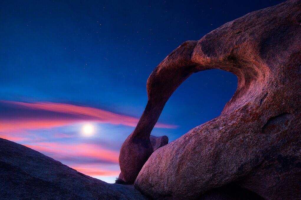
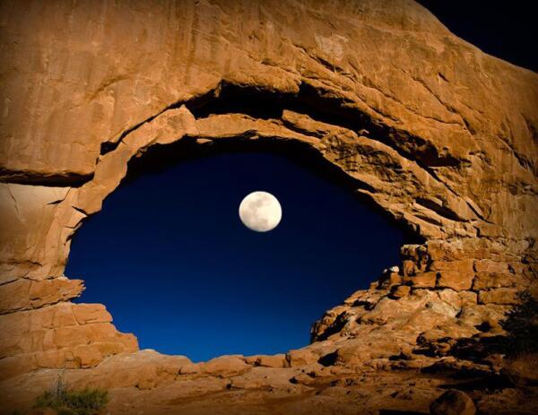
U.S. Department of Interior, Twitter feed: Beautiful view of the Moon over Mabius Mobius Arch in the Alabama Hills Recreation Area. #California @BLMca pic.twitter.com/u0KYyJ6p0S

Interesting points, reasons to like this image:

  1. No, that’s not the Sun.  It’s the Moon.
  2. Who knew California had natural arches?  I mean, it makes sense — but there’s one in Virginia, and a bunch of them at Arches National Park, and . . .
  3. An arch that should be in Utah, in the Alabama Hills, but not in Alabama, in California.
  4. Stars!
  5. Great photograph, obviously a long exposure.  Let’s see if we can find the name of the photographer.  Pox on Interior for failing to fit that into the caption. Photographer is Steve Perry, and you should check out his site (and buy some photos!). (Thanks, J. A. Higginbotham, for tracking that down.)
  6. America’s public lands, showing how they are unexcelled at astonishing us.
  7. What? Interior called the “Mabius Arch?” No, it’s the Mobius Arch!
  8. This place was named after the Confederate warship C.S.S. Alabama. Sympathetic miners making claims on minerals, it appears. “The unusual name Alabama Hills came about during the Civil War. In 1864 Southern sympathizers in Lone Pine discovered gold ‘in them thar hills.’ When they heard that a Confederate cruiser named the Alabama had burned, sunk or captured more than 60 Federal ships in less than two years they named their mining claims after the cruiser to celebrate. Before long the name applied to the whole area. Coincidentally, while Southerners were prospecting around Lone Pine, there were Union sympathizers 15 miles north near Independence. And when the Alabama was sunk off the coast of France by the U.S.S. Kearsarge in 1864, the Independence people struck back. They not only named their mining claims ‘Kearsarge’ but a mountain peak, a mountain pass, and a whole town as well.”
  9. More than 400 movies were shot using Alabama Hills for a backdrop, including How the West Was Won, Gunga Din (standing in for the hills of northern India) and the 1960 Audie Murphy classic, Hell Bent for Leather.
  10. Geologists will love that this area is a prime example of chemical erosion — rocks made out of the same stuff as the craggy Sierra Nevada Mountains in the distance, but eroded differently.
  11. Lichens by moonlight!  (Or is that just desert varnish?)

More:


Milky Way in Navajoland: YIKÁÍSDÁHÁ

May 13, 2014

Milky Way over Monument Valley Navajo Park. Photo by Gavin Heffernan and Harun Mehmedinović, from the video

Milky Way over Monument Valley Navajo Tribal Park. Photo by Gavin Heffernan and Harun Mehmedinović, from the video (which also features Grand Canyon National Park)

Phil Plait’s column/blog at Slate, Bad Astronomy, put me on to this one.  Wow.

You can see it at Vimeo, and read a lot more about the making of the film.

YIKÁÍSDÁHÁ (Navajo for Milky Way or “That Which Awaits the Dawn”)

Phil wrote:

And that they do. The Milky Way is the star of the show; the galactic bulge, disk, and dark fingers of vast dust lanes as clear as if this were taken from space. Well, sort of; I was impressed by the mix of clouds and sky, to be honest. The contrast was interesting, and it’s rather amazing the Milky Way could stand out so clearly above the cloud line.

One thing I want to point out specifically: At 2:10 in, a meteor flashes and leaves behind a curling wisp of what looks like smoke. This is called a persistent train, the vaporized remains of the meteoroid itself, and can glow for several minutes. The upper level winds from 60–100 km above Earth’s surface are what blow it into those curlicues.

More details, for more films from these guys:

Shot and Produced by: Gavin Heffernan and Harun Mehmedinović
Music: A Seated Night (Ambient) by Moby. Courtesy MobyGratis.com / Unknown Native Chant
Thanks: Northern Arizona University, Grand Canyon National Park, Monument Valley Tribal Park.

See other Sunchaser Timelapses on Vimeo here: vimeo.com/album/189653
LIKE Sunchaser Pictures on Facebook! facebook.com/SunchaserPicturesPage
LIKE Bloodhoney on Facebook! facebook.com/blood.honey.by.harun.mehmedinovic

For more from the artists:

BloodHoney.com
SunchaserPictures.com


Insta-Millard: Look alive, kids, Fuego is lurking!

May 12, 2014

One way to get the kids out of their sleeping bags in the morning, no?  Just alert them to the passing California condor, looking for something that doesn’t move, to eat.

USFWS PacificSouthwest:

USFWS PacificSouthwest: “Now that is up close and personal! Melissa Galieti snapped this picture of #Condor 470 ‘Fuego,’ May 5 in Big Sur, California. pic.twitter.com/QKvURadqaV

Only way to get closer to these majestic birds is to do what our cousin Amanda Holland did, and work with the Condor recovery project.

Might be a life’s work in there somewhere.


Milky Way from Joshua Tree N.P..

May 5, 2014

From the U.S Department of Interior Twitter feed:  To celebrate being named to the @TIME #Twitter140, here is an amazing photo from @JoshuaTreeNP. pic.twitter.com/F4DS5Xv9vq

From the U.S Department of Interior Twitter feed: To celebrate being named to the @TIME #Twitter140, here is an amazing photo from @JoshuaTreeNP. pic.twitter.com/F4DS5Xv9vq

Milky Way in a long exposure with a light-painted tree in Joshua Tree National Park, California.

More:


Arbor Day sunset in Redwood National Park

April 25, 2014

Another stunner from our public lands, from the Department of Interior’s Great American Outdoors Tumblr:

Department of Interior:  Let's end #ArborDay with this great shot from Redwood National Park in #California. pic.twitter.com/SzlkQASYFI

Department of Interior: Let’s end #ArborDay with this great shot from Redwood National Park in #California. pic.twitter.com/SzlkQASYFI

Today is Arbor Day, too?


Cross seas: Nature, or design?

April 16, 2014

Here’s just exactly the sort of thing that happens in nature that drives creationists nuts.  How could this happen without God personally working to confuse and/or delight the photographer?  Not to mention the physicist and mathematician.

Photo from the Twitter feed of Science Porn:

Photo from the Twitter feed of Science Porn: “Go home waves you’re drunk. This is called cross sea btw pic.twitter.com/5Cv1UUo8QX”

Where? Somewhere in France, one might gather from the flag on the structure (lighthouse?).

Turns out to be a Wikipedia photo, with this intriguing caption:

Crossing swells, consisting of near-cnoidal wave trains. Photo taken from Phares des Baleines (Whale Lighthouse) at the western point of Île de Ré (Isle of Rhé), France, in the Atlantic Ocean. The interaction of such near-solitons in shallow water may be modeled through the Kadomtsev–Petviashvili equation.

Oh, you remember that one, don’t you?  The Kadomtsev–Petviashvili equation?

At least we confirmed it was taken in France.

They do everything differently in France, don’t they?

Update:Got an e-mail suggestion that I include the equation itself.  You may certainly click to Wikipedia to find it; here’s what it says over there:

In mathematics and physics, the Kadomtsev–Petviashvili equation – or KP equation, named after Boris Borisovich Kadomtsev and Vladimir Iosifovich Petviashvili – is a partial differential equation to describe nonlinearwave motion. The KP equation is usually written as:

\displaystyle \partial_x(\partial_t u+u \partial_x u+\epsilon^2\partial_{xxx}u)+\lambda\partial_{yy}u=0

where \lambda=\pm 1. The above form shows that the KP equation is a generalization to two spatial dimensions, x and y, of the one-dimensional Korteweg–de Vries (KdV) equation. To be physically meaningful, the wave propagation direction has to be not-too-far from the x direction, i.e. with only slow variations of solutions in the y direction.

Like the KdV equation, the KP equation is completely integrable. It can also be solved using the inverse scattering transform much like the nonlinear Schrödinger equation.

Certainly the longest equation ever published at Millard Fillmore’s Bathtub.

Save


Sky and stars peeking into Antelope Canyon

April 11, 2014

Upper and Lower Antelope Canyon, near Page Arizona, get more visitors annually than just about any other canyon except the Grand Canyon.  They cover only a few miles.

You’re not familiar with Antelope Canyon?  You’ve seen the photos, even if you don’t know the name of the place — it’s a slot canyon, carved as with a wandering knife into the sandstone at the top of the cliffs leading to the Colorado River.

Over at EarthSky, I found a view you haven’t seen before.

Antelope Canyon at night by Sergio Garcia Rill. Stunning contrast of rock painted by light, and stars.  From EarthSky.com.  Visit Sergio’s website and read more about this adventure.

Antelope Canyon at night by Sergio Garcia Rill. Stunning contrast of rock painted by light, and stars. From EarthSky.com. Visit Sergio’s website and read more about this adventure.

Details from EarthSky.com:

Sergio Garcia Rill captured this beautiful image from within Upper Antelope Canyon in Arizona, which is the most visited slot canyon in the United States. A slot canyon is significantly deeper than it is wide. It’s formed by water rushing through rock. Sergio wrote:

During my recent trip to Arizona, I stopped by Page to get a chance at touring the now famous canyons (Upper and Lower Antelope) and I also had a chance to visit Upper Antelope at night.

I couldn’t really get too many shots with the sky (since the openings were very narrow and limited) but I liked this one in particular since I got a chance to set it up and do the light painting myself a couple of chambers behind from where my guide and another participant were working on another shot.

Thank you, Sergio.

Visit Sergio Garcia Rill’s Facebook page.

Click here for info about traveling to Upper and Lower Antelope Canyon.

Readers here may remember Page was the final destination of my late oldest brother, Jerry.  To his credit, he urged me to make a special trip to see Antelope Canyon, because most of the times I visited, it was closed, or impassable.  Alas, I have not yet been to the place.

This is one of the gems of the Diné, the Navajo Nation, and another good reason to get familiar with redrock country.


Some things never change: “We Want Beer,” in 1932 photo

April 8, 2014

http://twitter.com/History_Pics/status/453395574080172032

1932?  Heck, that’s every Friday in some offices I’ve worked in — and schools.


Dallas with rain clouds, March 27, 2014

March 29, 2014

Photo from the Dallas Karting Complex.  Dallas, evening of March 27, 2014.

Photo from the Dallas Karting Complex. Dallas, evening of March 27, 2014.  Photographer unidentified. David Worthington.

Funny thing is, this photo probably didn’t require much processing to look like this.  Advances in lighting, especially LEDs and color, mean that Dallas’s skyline can look much like this any night.

Just add a thunderhead to the northeast, and voila!

Nota bene: Mr. Higginbotham discovered the photographer to be David Worthington, who is selling prints.  I recommend Dallasites contact him to get one. (Anyone else, too; it’s a great shot.)


Milky Way in perspective, Northern to the Southern Cross

March 29, 2014

Found on Twitter, via @SciencePorn - One of the most beautiful pictures I've ever seen. Star photography by Nicholas Buer pic.twitter.com/RlwvSQNBAy

Found on Twitter, via @SciencePorn – One of the most beautiful pictures I’ve ever seen. Star photography by Nicholas Buer pic.twitter.com/RlwvSQNBAy. Much larger view here.

Nicholas Buer works hard to get these shots — a bit of a master, no?

This one was the Astronomy Picture of the Day (APOD) for January 27, 2014 (click that link for a much larger and more glorious view).  Much more detail there, revealing that this is much more of the Milky Way than you’d usually see.

From the Northern to the Southern Cross
Image Credit & Copyright: Nicholas Buer Explanation: There is a road that connects the Northern to the Southern Cross but you have to be at the right place and time to see it. The road, as pictured above, is actually the central band of our Milky Way Galaxy; the right place, in this case, is dark Laguna Cejar in Salar de Atacama of Northern Chile; and the right time was in early October, just after sunset. Many sky wonders were captured then, including the bright Moon, inside the Milky Way arch; Venus, just above the Moon; Saturn and Mercury, just below the Moon; the Large and Small Magellanic Clouds satellite galaxies, on the far left; red airglow near the horizon on the image left; and the lights of small towns at several locations across the horizon. One might guess that composing this 30-image panorama would have been a serene experience, but for that one would have required earplugs to ignore the continued brays of wild donkeys.


Save


Sunrise on the Shenandoah Mountains

March 11, 2014

This is a hopeful picture.

US Dept of Interior Tweet:  Beautiful #sunrise over @ShenandoahNPS last weekend. #Virginia #travel #nature pic.twitter.com/T2sEgczGsz

US Dept of Interior Tweet: Beautiful #sunrise over @ShenandoahNPS last weekend. #Virginia #travel #nature pic.twitter.com/T2sEgczGsz

Probably taken along the Blue Ridge Parkway.  At the bottom of the photo, note the stone wall, probably built by the Civilian Conservation Corps during the Franklin Roosevelt administration, and still contributing to America’s beauty and economy 80 years later.

I can imagine driving along, catching a beautiful sunrise, but not being at a point to stop to photograph it.  Driving farther along, the photographer found a safe place to stop, but the sunrise itself was gone by 15 minutes.  With the aid of a young tree, however, the photographer can recapture that moment of the Sun’s peeking over the horizon, without special effects.  Nice thought for the shot.


It’s a desert out there: Salmon Research at Iliamna Lake, Alaska 2013 – Jason Ching film

March 6, 2014

Sitting in a hot trailer out on the northern New Mexico desert, Arizona State’s great soil scientist Tom Brown tipped back his cowboy hat, and asked me if I had been lonely over the previous week.  Classes at BYU started up in August, and our other field workers on the project, with the University of Utah Engineering Experiment Station, for EPA and New Mexico Public Service, had gone back to class.  My classes at the University of Utah didn’t start for a few more weeks — so I was holding down the fort by myself.

Dr. Brown’s expertise in reading air pollution damage on desert plants propelled a good part of the work.  He showed me how to tell the difference between sulfur dioxide damage and nitrogen oxide damage on grasses and other plants, and how to tell  when it was insects.  He had some great stories.  As a Mormon, he was also full of advice on life.

The Shiprock, a plug from an ancient volcano, left after the mountain eroded away. Near Shiprock, New Mexico, on the Navajo Reservation. Wikipedia image by Bowie Snodgrass

The Shiprock, a plug from an ancient volcano, left after the mountain eroded away. Near Shiprock, New Mexico, on the Navajo Reservation. Wikipedia image by Bowie Snodgrass

Between Farmington where our hotel was, and Teec Nos Pos where our most distant (non-wet) sampling site was, radio reception was lousy most of the time.  The Navajo-language AM station in Farmington played some of the best music, and sometimes it could be caught as far west as Shiprock .  Most of the time, driving across Navajoland, I had nothing but my thoughts to accompany me.  Well, thoughts and the all-too-frequent Navajo funeral processions, 50 pickups long on a two-lane highway.

“No, not lonely.  There’s a lot of work, I’ve got good books, and sleep is good,” I told him.

“Enjoy it,” Brown said.  “The best time for any researcher is out in the field.  And when you’re young, and you haven’t seen it all, it’s better.”

Indian rice grass in the sunlight (Oryzopsis hymendoides). Photo from the Intermountain Herbarium, Utah State University Extension Service

Indian rice grass in the sunlight (Oryzopsis hymendoides). Photo from the Intermountain Herbarium, Utah State University Extension Service

Brown spent a couple of days.  Within a couple of weeks I turned everything over to other Ph.Ds to shut down the wet sampling for the winter, and caught a ride back to Provo (closer to where I lived) in a Cessna with a pilot who loved to fly low enough to see the canyons along the way.  Get a map and think of the possibilities, with a landing in Moab; if you don’t drool at the thought of such a trip in the air but not too high, if your heart doesn’t actually beat faster thinking of such a trip, go see your physician for treatment.

By that time I was out of film, alas.

My few summers out in the desert chasing air pollution stay fixed in the surface of my memory.  Indian rice grass still excites me in the afternoon sun (Oryzopsis hymenoides) — one of the more beautiful of grasses, one of the more beautiful and soil-holding desert plants.  When hear the word “volcano,” I think of the Shiprock.  When I read of air pollution damage, I think of all the pinon, aspen, cottonwoods, firs and other trees we gassed; when I see aspen in its full autumn glory, I remember those dozen  or so leaves we caused to turn with SO2 (slight damage turns the leaves colors; greater damage makes them necrotic, a bit of a mirror of autumn).

All of that came back as I watched Jason Ching’s film, “Salmon Research at Iliamna Lake, Alaska 2013,” a simple six-minute compilation of shots taken with modern electronic cameras, including the hardy little GoPros, and with assistance from a DJI Phantom Quadcopter drone.  Wow, what we could have captured with that equipment!

Ching’s description of the film:

This video showcases the scenery of Iliamna Lake and shows some of the 2013 research of the Alaska Salmon Program’s Iliamna Lake research station, one of four main facilities in Southwest Alaska . Established in the 1940’s, the Program’s research has been focused on ecology and fisheries management relating primarily to salmon and the environment in Bristol Bay, Alaska. Check out our program at: fish.washington.edu/research/alaska/

Filmed and edited by Jason Ching
Additional footage provided by Cyril Michel

Song:
“The long & quiet flight of the pelican” by Ending Satellites (endingsatellites.com)

Additonal Information:
Shot on a Canon 5d Mark II, Canon T3i, GoPro Hero 2 and GoPro Hero 3
DJI Phantom Quadcopter

JasonSChing.com

I am very grateful to be a part of such a long standing, and prominent program that allows me to work in the field in such an incredible setting with fantastic folks. This is the second video I created, the first one in 2012, to merely show family and friends back at home what I’ve been up to during the summer. This video was often shot between, or during field sampling events so a special thanks goes out to all those who supported me by continuing to work while I fiddled with camera gear.

Do you really want to get kids more interested in science?  Show them this stuff.  Scientists get the front seats on cool stuff — and they often get paid to do it, though they won’t get rich.

Researching life, and rocks, geography and landscape, and water resources, one may be alone in a desert, or a desert of human communication.  Then one discovers just how beautiful the desert  is, all the time.

More:

  • Yes, I know; Indian rice grass has been renomenclaturedAchnatherum hymenoides (Roemer & J.A. Shultes) Barkworth, or Stipa hymenoides Roemer & J.S. Shultes, or Oryzopsis hymenoides (Roemer & J.S. Shultes) Ricker ex Piper.  It is the State Grass of Utah

North Korea: A hole in the fabric of the 21st century

February 25, 2014

Here’s a photograph of one of the greatest, and longest-running tragedies of our time.

No, that’s not a stretch of water in the red circle.  That’s North Korea, at night, blacked out by a lack of electrical lights.

Tweetpic from the Washington Post: North Korea looks like a sea of misery in this photo from space http://wapo.st/1c1B84q  via @KnowMoreWP pic.twitter.com/nB3g8fa63Q

Tweetpic from the Washington Post: North Korea looks like a sea of misery in this photo from space http://wapo.st/1c1B84q via @KnowMoreWP pic.twitter.com/nB3g8fa63Q

It’s a photo from the International Space Station taken in January.

The KnowMore blog from the Post describes the tragedy, and points to even more disturbing stories:

North Korea appears as nothing more than a shadow in the above photograph, taken at night aboard the International Space Station last month. South Korea’s eastern coastline is indistinguishable from the demilitarized zone along the border with the North, as though the Sea of Japan flowed into the Yellow Sea and Pyongyang were an island in a strait separating South Korea from China.

North Korea’s interior is nearly invisible from orbit at night, just as what happens inside the country on a day-to-day basis is largely invisible to the outside world. U.N. investigators managed to shine a little light into North Korea’s darkest corners last month.  [Click here to get to the U.N. report]

I’ve used similar photos in class.  It’s a powerful exercise.  North Korea is as dark as undeveloped and largely unpopulated areas of the Congo River Basin, the Australian Outback, the Arabian Peninsula’s “Empty Quarter,” and almost as dark as Antarctica.

No doubt stargazing is good in some of those dark spots in North Korea.  This is one case where the absence of light pollution does NOT indicate good planning, but instead an amazing paucity of rational development.


Photography as an instrument of history: Ukraine’s Independence Square

February 21, 2014

Tweet from the Wall Street Journal shows, in very dramatic form, how photographs can be used to record history and current events, telling a story that words just cannot.

 WSJ Wall Street Journal - #Ukraine's Independence Square: then and now http://on.wsj.com/1d9q7IL  pic.twitter.com/vzqPKj79Cb

WSJ Wall Street Journal – #Ukraine’s Independence Square: then and now http://on.wsj.com/1d9q7IL pic.twitter.com/vzqPKj79Cb

In Ukraine, there’s an enormous difference between 2009 and 2014.  In five years, Kiev is a different city.

Do we attribute the differences to corrupt government, to the assault on democratic institutions, or to the movement to end the corruption and boost democracy?

It’s more impressive that I can show in a link here; at the WSJ site, the two photos are interactive — you can grab the middle line with your mouse and move it to see the damage in 2014.  Check it out.

Are there similar photographic comparisons for Syria, Egypt, Yemen, Venezuela, Brazil, China, Britain, the United States?  If you know of some, or if you have created some, will you share?


When the Moon hits your eye, in Arches NP

February 12, 2014

Photo by Lynn Sessions;

Photo by Lynn Sessions; “THE EYE OF THE #MOON: North Window arch at Arches National Park in #Utah. #NatGeo pic.twitter.com/XwHfdWK5Ft

It’s just a click of the shutter?  Ha!

I’m assuming not a lot of post-photo processing on this. Lynn Sessions had to figure out when the Moon would be in the North Window Arch, calculate exposure, and shoot off enough of them to get a decent shot before the Moon moved.  I suspect the rocks were “painted” with a flashlight during the exposure.

(Haven’t yet found the technical details of the shot. But I did find this about the photographer:
I’m a frustrated amateur photographer who is trying to visit every corner in Utah as well as hike/photograph every canyon in southern Utah. More at http://www.DreamBreeze.com )

Patience, planning, creativity — then just push the button.

More: