Location: N16°55.642′, W96°21.618′ photo taken 2008.02.26 in Oaxaca, Mexico by Paula Darwent Near entrance of Mercado de Artesanias (Calle Reforma), San Pablo Villa de Mitla
Perhaps this sign is supposed to warn us against water on the road. Or mirages on the road.
With all the cameras around, if everybody just points their own camera to the skies and starts shooting, we’ll get some good shots.
Tonight the Texas Storm Chasers sent this one out:
Texas Storm Chasers @TxStormChasers 27m RT @TaylorKLynn: @TxStormChasers Took these from my phone of the storm heading into northern Lubbock! pic.twitter.com/5LQX1qBWsN #txwx
Looks like “Night on Storm Prairie” to me. (Where’s Disney when you need em?)
Shot with a camera phone, I’m guessing from inside a hotel (are those reflections in the window?). Not sure who shot it, so I’ve just credited “Texas Storm Chasers.”
Normally I might just let this beautiful photo slide by without comment.
In this case, I find this particularly frustrating. See that creature? That’s the same goat that blocked my trail in Glacier National Park. I’m sure of it. I’d recognize those beady eyes and horns anywhere! (See the first story linked to in the “more’ section; maybe this goat stopped in Washington on the way to Alaska.)
He’s probably in Alaska now under the Federal Goat Protection Program.
Interior US Dept of Interior 6h Caption from the Department of Interior: That’s quite the hike to the top. Harding Icefield Trail @KenaiFjordsNPS. #alaska pic.twitter.com/yozsSLnrcD
He probably thinks he’s safe there at Kenai Fjords National Park. Ha! He’s farther away, but that just means I have farther to travel to find him!
I’m taking a longer telephoto, a wide angle, and a first aid kit, next time. I’ll be prepared!
A sign photographed in Australia, in the Knuth Collection.
Your nominations for captions welcomed in comments.
More, sorta — or maybe, “tangentially related” is a better description:
Donald Knuth at a reception for the Open Content Alliance, hosted by the Internet Archive. Taken October 25, 2005 by Jacob Appelbaum in San Francisco. (Wikipedia image)
You can’t put all that on a road sign. But you can put a picture of his bowtie there. Honestly, we laughed out loud when we saw one for the first time.
I never could find one of the signs where it might be safe to pull off get a good photograph. Surely someone in Illinois would have one, right?
Just try to find a good picture of these great signs. I finally found this one on Flickr:
Paul Simon Freeway Bowtie Sign on I-55 near Edwardsville, IL_DSCN9495c – Flickr photo by Wampa-One
Paul Simon, the Illinois politician, was a great guy. Search for photos of the Tom Landry Highway signs in Texas, you’ll get a boatload of close-up shots. Come on, Illinois: Somebody go get a photo of those “Paul Simon Freeway” signs worthy of the man, and post it on the ‘net!
U.S. Sen. Paul Simon, D-Illinois. Biographical Directory of the U.S. Congress
Spread the word; friends don't allow friends to repeat history.
Either someone just spent a very cold night to get a photo, or they’re getting ready to spend a very cold night.
Which is it?
US Dept of Interior: If you haven’t seen Steens Mountain in #Oregon, you really should check out this stunning photo from @BLMOregon pic.twitter.com/H2eePMmfsX
Steens Mountain is a large fault-block mountain in the southeastern part of the U.S. state of Oregon. Located in Harney County, it stretches some 50 miles (80 km) long north to south, and rises from alongside the Alvord Desert at elevation of about 4,200 feet (1,300 m) to a summit elevation of 9,733 feet (2,967 m). It is sometimes confused with a mountain range, but is properly a single mountain.
Can the scientist appreciate the beauty of creation as much as the non-scientist religious person?
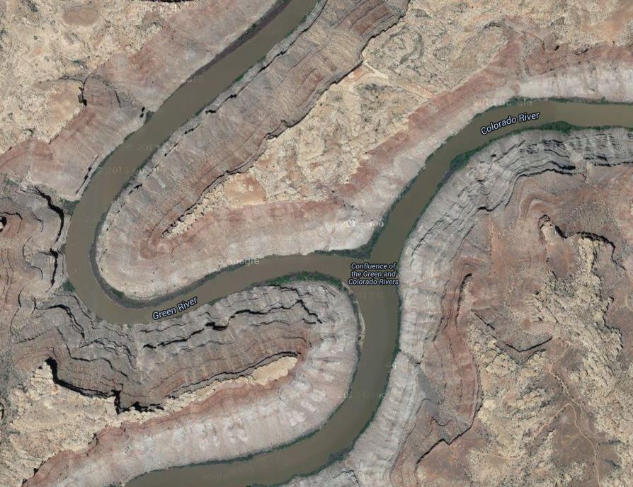
Can you get the joke in this photo, without a smattering of knowledge of geography, and languages? Or am I looking at it wrong?
Confluence of the Green and Colorado Rivers, in Canyonlands National Park. Photo by Jim Collins, posted on Facebook by Canyonlands National Park
It’s a joke on a planetary scale, if not a cosmic one.
(Hints: This is a photo looking from the north, I think; “Colorado” means “red” in Spanish.)
Update: Okay, Mr. Higginbotham convinced me. We’re looking from the west, and that’s the Colorado coming from the top of the picture, and the Green coming from the bottom left; then the conjoined streams flow away, to the bottom right. So, in the photo, the Colorado River is, appropriately, red, while the Green River is, fittingly, green
Not a majestic joke by Mother Nature, but a poetic way to remind us of the names of these rivers.
Poetry that might make us smile, too.
(It’s rare that these rivers run such dramatically different colors, especially with the Colorado that red, that far north.)
Google Maps aerial photo of the Confluence of the Green and Colorado Rivers; match the geography with the other photo, and note the labels on this one. Rotate this picture 90 degrees to the left, it matches up better. Tip of the old scrub brush to Mr. J. A. Higginbotham.
I’m falling down in my Mark Twain fandom, obviously. Barbara Schmidt, who keeps the fine site, TwainQuotes (www.twainquotes.com), features this photo of Mark Twain holding an open copy of The Adventures of Huckleberry Finn, on one of the main pages at her site.
I did not know such a statue of Twain existed in Texas, let alone within an hour’s travel from my home. I’ll have to track it down.
Mark Twain at Sit-by-me Statutes, Waymarking.com; “Mark Twain is located off Trinity Park Drive in Trinity Park in Fort Worth, Texas. He sits on the right-hand side of the bench, overlooking the Trinity River and holding a copy of Huckleberry Finn in his hand. The statue was ‘Given to the families of Fort Worth for the pleasure of reading together’ by Red Oaks Books and was dedicated on 28 June 2007.”
Grant Snider’s “American Art, exploring a country through its paintings”
In the course of a junior-level, high school U.S. history class, students should experience each of these works, and many others. This is one whimsical way to work with serious and uplifting material, no?
Since that formative vacation, the art museum is always one my of first stops in visiting a new city. In the comic above, I’ve curated my ideal collection of 20th-century American art. Here’s a list of works in order of appearance:
(This is not a place to bolster creationist ideas. This is real science, looking at God’s handiwork first hand.)
A North Carolina university makes field trips to Yosemite? I’d love to take that class!
Watching this film, you get a sense of how important it can be to the education of our children to travel in the summers, to take vacations to our National Parks, and to places like Yosemite.
Where are you taking your kids this summer? Kids, where are you going?
Enjoy it. Geology lessons are often fun, and this one, on film, is more fun than most.
Mount Everest North Face as seen from the path to the base camp, Tibet. Wikipedia image
A pick from the staff at Vimeo.
It’s astonishing how many people ascend Mt. Everest in our time. Look at the tent city.
Everest’s beauty is stunning, always has been, but is now revealed by high-definition image capture unavailable just 10 years ago, now distributed by the internet.
These photos are mostly from about 25,000 feet in elevation — about where much domestic U.S. air travel occurs. The weather up there is spectacular, if you’re not in it. It’s spectactular if you’re in it, too — but I’m viewing it from Dallas, where we’re above 90 degrees in the day, now, just 800 feet above sea level.
One of the most rewarding parts of the journey was being able to share it with thousands of students on epals.com/everest
This time lapse video is comprised of thousands of photographs, processed and assembled on Mt. Everest.
Shot on a Canon 5D Mark II
-Canon 2.8 16-35mm
-Canon 2.8 24-70mm
-Canon 2.8 70-200mm (which was way to heavy to carry beyond 6400M)
-TL Remote was purchased off eBay
Edited in Final Cut Pro
Processed in Adobe LightRoom
Movies compiled in Quicktime
Caption from America’s Great Outdoors: There are many unique areas within America’s public lands. Case in point this spot in Glen Canyon National Recreation Area. Photo: Cassandra Crowley
Photographer Randy Halverson lives and shoots in South Dakota, mostly. Here’s an almost-five minute piece showing the night skies of South Dakota with a little Wyoming thrown in.
Halverson’s description:
If you have ever been in a wide open landscape the most interesting thing isn’t necessarily the landscape itself, but what you see coming over the horizon. Growing up in South Dakota the landscape itself can be beautiful at times, but that doesn’t compare to what the sky can do, especially at night. Combine that with the landscape, and it makes for great photo opportunities. More information and stills at dakotalapse.com/2013/06/horizons/
Bear McCreary (The Walking Dead, Defiance, Battlestar Galactica, etc) once again helped me with some original music for the video. This time he suggested adding vocals to the mix. Brendan McCreary and his band (Young Beautiful in a Hurry) did just that. They came up with “I Forever” The single is available on iTunes tinyurl.com/pgrq45p , Amazon and other online sources.
I shot Horizons from April – October 2012 mostly in South Dakota, but also some at Devils Tower in Wyoming. From the rugged Badlands, the White River valley and the Black Hills, the horizons seem to endlessly change.
Photography and Editing – Randy Halverson
Production Assistants – River Halverson and Kelly McILhone
Color Correction – Jeff Zueger – Spectrum Films
Sponsors:
Dynamic Perception – The Stage Zero and Stage One dollies were used in many of the shots. I can’t recommend them enough for a quality product at a low price. dynamicperception.com/#oid=1005_1
Borrowlenses – Throughout the summer I got some great Canon and Zeiss lenses from Borrowlenses to use in the shoot. They have great service and every lens performed flawlessly. So if you ever want to try out a lens ,or just need one for an special shoot, give them a try! borrowlenses.com
Granite Bay Software – I try to avoid flicker in sunset or daytime timelapse while shooting. But sometimes it is unavoidable. I used GBDeflicker to smooth out the flicker in some of the sunset timelapse. granitebaysoftware.com/
Equipment Used
Canon 5D Mark III, sometimes with a 2nd from Borrowlenses.com
Canon 5D Mark II
Canon 60D
I used a variety of lenses, many from Borrowlenses.com
Canon 14, 16-35, 24-70, 50 F1.2, 70-200mm lenses
Zeiss 21, 25, 35mm lenses
Nikon 14-24mm with Novoflex Adapter
Available in 4K resolution.
Contact for licensing footage, shooting rates or anything else.
Randy Halverson dakotalapse@gmail.com
Or, until that account is unsuspended by the forces supporting Donald Trump: Follow @FillmoreWhite, the account of the Millard Fillmore White House Library
We've been soaking in the Bathtub for several months, long enough that some of the links we've used have gone to the Great Internet in the Sky.
If you find a dead link, please leave a comment to that post, and tell us what link has expired.
Thanks!
Retired teacher of law, economics, history, AP government, psychology and science. Former speechwriter, press guy and legislative aide in U.S. Senate. Former Department of Education. Former airline real estate, telecom towers, Big 6 (that old!) consultant. Lab and field research in air pollution control.
My blog, Millard Fillmore's Bathtub, is a continuing experiment to test how to use blogs to improve and speed up learning processes for students, perhaps by making some of the courses actually interesting. It is a blog for teachers, to see if we can use blogs. It is for people interested in social studies and social studies education, to see if we can learn to get it right. It's a blog for science fans, to promote good science and good science policy. It's a blog for people interested in good government and how to achieve it.
BS in Mass Communication, University of Utah
Graduate study in Rhetoric and Speech Communication, University of Arizona
JD from the National Law Center, George Washington University


 Posted by Ed Darrell