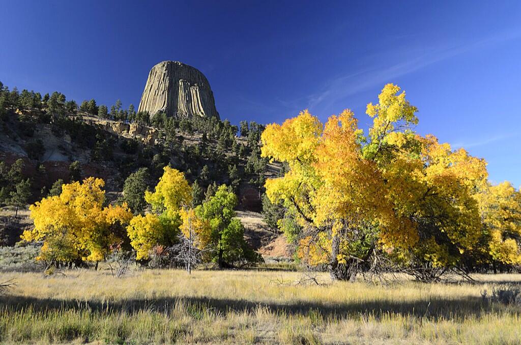
US Dept of Interior @Interior 16h Is there any doubt fall is best enjoyed in America’s great outdoors? Here’s great example from Devils Tower NM. pic.twitter.com/YRo1U8DSMQ
“Devils Tower NM” means “National Monument,” not New Mexico. This volcano remnant stands in Wyoming.
Old friend, painter and photographer Nancy Christensen Littlefield offers a more close-up view.
Devil’s Tower on a July morning. Photo by Nancy Christensen LIttlefield.
And looking even closer, you spy Richard Dreyfus never-wanna-bes:
Climbers on Devils Tower. Photographer Nancy Littlefield said: “There were Native American prayer bundles along the trail around the base. It really is awe inspiring. Early morning gives you the best light to photograph it by.”
Devils Tower is the plug of an old volcano. What’s left is the magma that hardened, and what we see is left after the softer cone eroded away.
We had to fight to keep this stuff in Texas science books.
Then, out on the street, I see a U-Haul truck.
U-Haul truck features geographic information, and geology information, about Arkansas and its Crater of Diamonds State Park.
Detail: U-Haul truck features a graphic description of the geology and information about Arkansas’s Crater of Diamonds State Park.
Well played, U-Haul. Can Texas catch up?
Update, October 24, 2013: Turns out U-Haul has a website that features all of the graphics they use on their trucks. I sense a geography or state history assignment in here, somewhere, social studies teachers. Reminds me of the animals that used to (still do?) grace the tails of Frontier Airlines airplanes, the Native American on the tails of Alaska Airlines, and other specific destination promoting tricks businesses have used over the years. Wish more businesses would do that.
Planning a trip to Hawk Mountain this weekend? Arrive early to enjoy great views of low-hanging fog and to see the sun peek out over the valley. It’s a great way to start any day. — with Quelia Paulino at Hawk Mountain Sanctuary Association.
From Astronomy Picture of the Day: Earth at Equinox. From the Russian meteorological satellite Elektro-L
Explanation from NASA:
Equinox Earth Image Credit: Roscosmos / NTSOMZ / zelenyikot.livejournal.com
Courtesy: Igor Tirsky, Vitaliy Egorov Explanation: From a geostationary orbit 36,000 kilometers above the equator, Russian meteorological satellite Elektro-L takes high-resolution images our fair planet every 30 minutes. But only twice a year, during an Equinox, can it capture an image like this one, showing an entire hemisphere bathed in sunlight. At an Equinox, the Earth’s axis of rotation is not tilted toward or away from the Sun, so the solar illumination can extend to both the planet’s poles. Of course, this Elektro-L picture was recorded on September 22nd, at the northern hemisphere’s autumnal equinox. For a moment on that date, the Sun was behind the geostationary satellite and a telltale glint of reflected sunlight is seen crossing the equator, at the location on the planet with satellite and sun directly overhead (5MB animated gif).
Wait. Animated .gif? Cool!
The Earth at equinox, 2013; from Russan space program, via NASA.
You do discuss equinoxes in your social studies classes, right?
Stunning southern night sky in Ofu Island in the National Park of American Samoa! They get a brighter, richer view of the Milky Way in the Southern Hemisphere due to the location on the globe. This is the only national park found in the Southern Hemisphere. Photo: National Park Service
Many Americans seem unaware of worldwide holdings of the U.S. in territories, thinking the last territory was closed when Oklahoma or Arizona entered the union, or maybe Alaska or Hawaii. U.S. territories today include the Northern Mariana Islands, Guam (from the Spanish American War), Puerto Rico (from the same war), and the U.S. Virgin Islands, as organized territories. American Samoa is an “unorganized territory,” along with series of other islands in the Pacific: Baker Island, Howland Island, Palmyra Atoll, Johnson Atoll, Jarvis Island, Kingman Reef, the Midway Islands, and Wake Island; and in the Caribbean, Bajo Nuevo Bank, Navassa Island (also claimed by Haiti), and Serranilla Bank, also claimed by Colombia.
Most of these islands offer much better star-gazing than is ever possible in Dallas.
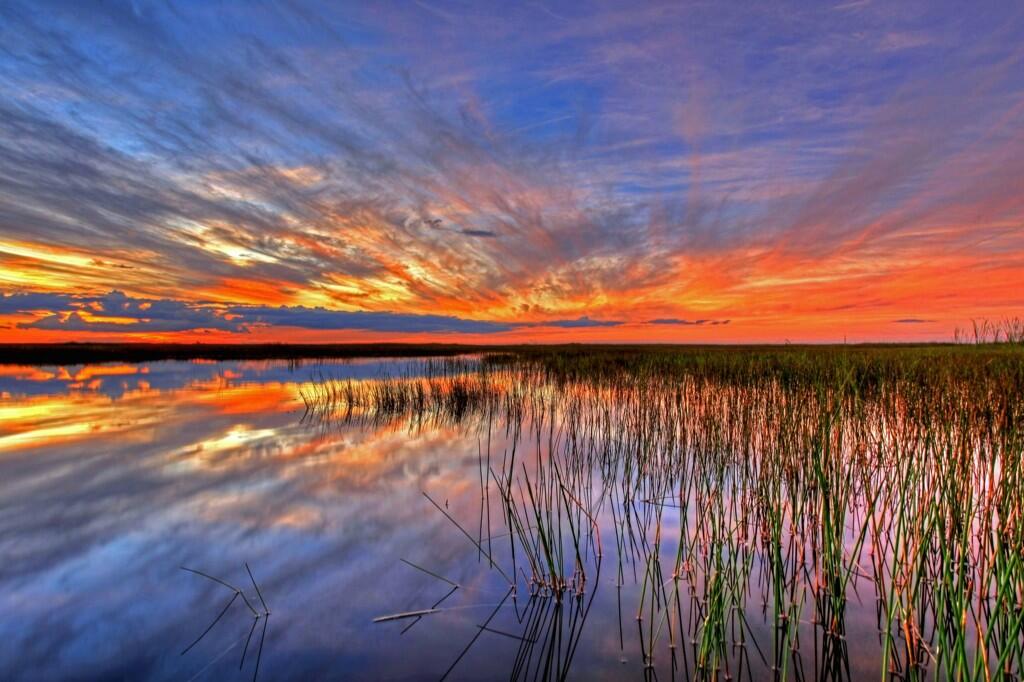
Caption from Interior’s Tweet: Sometimes there are no words to describe America’s public lands. This photo @EvergladesNPS proves it. #Florida pic.twitter.com/3l7fnrcfsG
Everglades National Park, in Florida, is a great example of wild lands that belong to all Americans, that we almost let slip away.
I’m not sure a painter could do a more stunning version of this view.
More:
Location map: Everglades National Park in red. Wikipedia photo
World and U.S. history classes should be long past this point, but the photo just recently surfaced:
From America’s Outdoors: Bering Land Bridge National Preserve – Gone are the shockingly bright pinks, yellows and purples of summer, replaced by deeper and darker reds, yellows, greens and the beginnings of brown, all of equal vibrancy and beauty. And soon, as the 34 degree weather and diminishing daylight would lead us to believe, a blanket of white will fall upon the landscape. Enjoy the change of seasons wherever you may be!
Bering Land Bridge National Preserve? Did you even know there was such a thing? Part of our public lands, your tax dollars at work.
Not a place for a Sunday drive. There are no roads to get to the place. For students, this site offers a lot of photos and interesting stuff for projects in history (human migrations) and geography (land forms, lava flows, migration routes, wilderness).
I was lucky enough to be sent to Rio on assignment to shoot some 4K and 10K timelapse footage for a major electronics manufacturer. This video is a compilation of some of the footage I shot there. Most of the locations are within the city of Rio De Janeiro, but I also traveled to the famous Iguazú Falls on the border of the Brazilian state of Paraná and the Argentinian province of Misiones. In 2011 Iguazú Falls was announced as one of the seven winners of the New Seven Wonders of Nature by the New Seven Wonders of the World Foundation.
RIO DE JANEIRO
No wonder the beautiful city of Rio De Janeiro was chosen to host the 2014 FIFA World Cup and the 2016 Summer Olympics. Rio de Janeiro, or simply Rio, is the capital city of the State of Rio de Janeiro, the second largest city of Brazil, and the third largest metropolitan area and agglomeration in South America, boasting approximately 6.3 million people within the city proper. Part of the city has been designated as a World Heritage Site, named “Rio de Janeiro: Carioca Landscapes between the Mountain and the Sea”, identified by UNESCO in the category Cultural Landscape.
Rio de Janeiro is one of the most visited cities in the southern hemisphere and is known for its natural settings, carnival celebrations, samba, Bossa Nova, balneario beaches such as Barra da Tijuca, Copacabana, Ipanema, and Leblon. Some of the most famous landmarks in addition to the beaches include the giant statue of Christ the Redeemer (“Cristo Redentor”) atop Corcovado mountain, named one of the New Seven Wonders of the World; Sugarloaf mountain (Pão de Açúcar) with its cable car; the Sambódromo, a permanent grandstand-lined parade avenue which is used during Carnival; and Maracanã Stadium, one of the world’s largest football stadiums.
I hope you enjoy the video!
Camera Gear:
Canon 5DIII
Canon 5DII
PhaseOne IQ180
Various Canon lenses
Special thanks to:
My production assistant José Olímpio ( joseolimpio.com ). Without his help this video would not have been possible. If you are ever in Rio and need a local production person I highly recommend José.
View from Longs Peak, September 2, 2013; 14,259 ft. Photo by Xiang Li.
Xiang Li and James Darrell summited the mountain yesterday, a bit tougher climb than they had expected. No view like that comes without some great effort somewhere. They topped Grays Peak a couple of weeks ago — a slightly higher mountain (20 feet), but an easier climb.
Spectacular photo of Glen Canyon Dam, in the early morning, with a thunderstorm to the north. This photo was taken close to the spot where Norman Rockwell painted the dam about 40 years ago.
Electricity is in the air at Glen Canyon! Although the Glen Canyon Dam produces hydroelectric power around the clock, an early morning thunderstorm really cranked up the voltage earlier this month. Use caution when planning your upcoming outdoor activities as intense thunderstorms are common this time of year. (Bureau of Reclamation/Interior Facebook entry; photo Credit: David Bailey)
13-year-old paperboy Chester Kahapea happily hawks a commemorative edition of the Honolulu Star-Bulletin with the headline showing the state had achieved statehood after the U.S. House of Representatives passed the law authorizing Hawaii as a state. Star-Bulletin photo by Murray Befeler.
Specimen copy of the ballot used by Hawaiians in a June 27, 1959, plebiscite to approve conditions of statehood. Image from Hawaii Magazine, 2009
After the U.S. annexed Hawaii in 1898 (in action separate from the Spanish-American War) attempts at getting Hawaii admitted as a state got rolling. After World War II, with the strategic importance of the islands firmly implanted in Americans’ minds, the project picked up some steam. Still, it was 14 years after the end of the war that agreements were worked out between the people of Hawaii, the Hawaiian royal family, Congress and the executive branch. The deal passed into law had to be ratified by a plebiscite among Hawaiian citizens. The proposition won approval with 94% of votes in favor.
Other than the tiny handful of loudmouth birthers, most Americans today are happy to have Hawaii as a state, the fifth richest in the U.S. by personal income. The nation has a lot of good and great beaches, but the idea of catching sun and surf in Hawaii on vacation might be considered an idealized part of the American dream.
Hawaiian and U.S. flags fly from the stern of a boat touring Hawaii. Are these flags displayed properly, under the U.S. flag code?
From Prologue, the blog of the National Archives: This petition, rolled onto a wooden spool, was signed by 116,000 supporters of Hawaii statehood and presented to the U.S. Senate on February 26, 1954. (RG 46, Records of the U.S. Senate)
U.S. postage stamp issued in 2009 commemorating the 50th anniversary of Hawaii’s admission to the union.
Contrast the first class postage price above with the airmail postage price of this stamp issued in 1959 — August 21, 1959 7¢ Rose Hawaii Statehood C55 26432. Wikipedia image
Spread the word; friends don't allow friends to repeat history.
Can the scientist appreciate the beauty of creation as much as the non-scientist religious person?
Can you get the joke in this photo, without a smattering of knowledge of geography, and languages? Or am I looking at it wrong?
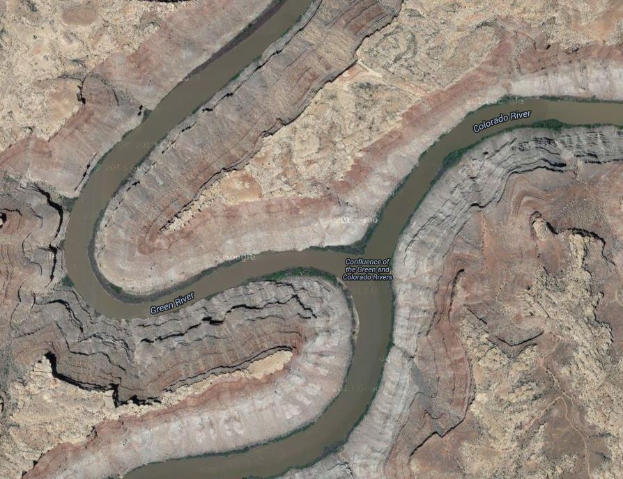
Confluence of the Green and Colorado Rivers, in Canyonlands National Park. Photo by Jim Collins, posted on Facebook by Canyonlands National Park
It’s a joke on a planetary scale, if not a cosmic one.
(Hints: This is a photo looking from the north, I think; “Colorado” means “red” in Spanish.)
Update: Okay, Mr. Higginbotham convinced me. We’re looking from the west, and that’s the Colorado coming from the top of the picture, and the Green coming from the bottom left; then the conjoined streams flow away, to the bottom right. So, in the photo, the Colorado River is, appropriately, red, while the Green River is, fittingly, green
Not a majestic joke by Mother Nature, but a poetic way to remind us of the names of these rivers.
Poetry that might make us smile, too.
(It’s rare that these rivers run such dramatically different colors, especially with the Colorado that red, that far north.)
Google Maps aerial photo of the Confluence of the Green and Colorado Rivers; match the geography with the other photo, and note the labels on this one. Rotate this picture 90 degrees to the left, it matches up better. Tip of the old scrub brush to Mr. J. A. Higginbotham.
Adelie penguins struggle to survive changes in their nesting and feeding sites caused by warming air and waters around Antarctica
New, very short film from the E. O. Wilson Biodiversity Foundation highlights threats to Adelie penguins from climate change, already. Actor and conservation activist Harrison Ford narrated “Ghost Rookeries, Climate Change and the Adelie Penguin.”
Details from the Biodiversity Foundation at their YouTube site:
Published on Jun 26, 2013
“Ghost Rookeries,” narrated by actor, conservationist, and member of the E.O. Wilson Biodiversity Foundation (EOWBF) Board of Advisors Harrison Ford, conveys the story of the Adelie Penguin, whose habitat—and thus the biodiversity of all of Antarctica—is being threatened by real-time environmental changes.
“The consequences of a loss of biodiversity could encompass everything from altering key Antarctic marine food chains to the loss of species that may hold cures to cancer,” writes Dr. James McClintock, whose recent book, ‘Lost Antarctica: Adventures in a Disappearing Land’ (Palgrave/MacMilllan, 2012), forms the basis of “Ghost Rookeries.”
The E.O. Wilson Biodiversity Foundation (EOWBF) and the Association of Zoos and Aquariums (AZA) will be embarking on an exciting new initiative beginning in the summer of 2013. Beginning with “Ghost Rookeries: Climate Change and the Adelie Penguin” (4 minutes, 2013), short videos produced by the EOWBF will be shown at select AZA-accredited zoos and aquariums located in the United States. With the vast reach of AZA-accredited zoos and aquariums, “Ghost Rookeries” and future videos will be seen by millions of visitors.
Dr. Paula Ehrlich, President and CEO of the EOWBF, calls “Ghost Rookeries” and the partnership with AZA “. . . a wonderful way to engage audiences about the importance of preserving our biological heritage through story. The Adelie Penguin is an iconic story, a symbol, of the real-time effect of climate change on biodiversity.”
This film looks at a small part of the Adelie penguin population, on Torgerson Island, near Palmer Station. This population symbolizes the difficulties of dealing with climate change, or even knowing what the effects will be. Critics of pollution control to stop climate change argue that populations of all animals and plants will adapt. Indeed the last decade saw a rise in total numbers of Adelies across Antarctic waters, and Gentoo penguins have set up new colonies to avoid warming air and waters.
More careful watchers note problems, though. Warming air, and decreasing hard ice, brings more snow — nominally good, if one assumes the snow turns to ice. In this case, the snows are brief, and they melt quickly. It’s the cold meltwater that kills the chicks, drowning them. This may be counterintuitive, or even ironic, that warming causes a cold water seabird to drown, or die of hypothermia. Nature is stranger than we can imagine, and often strange enough that it defies the understanding of scientifically-dilettante politicians.
Generally the loss of ice is the biggest problem for penguins; specific populations face entirely different threats, however, depending on the local effects of climate change.
Dr. Jim McClintock, in Antarctica. A professor at the University of Alabama-Birmingham, he wrote Antarctica Lost, upon which the film about the Adelie penguins is based.
The film is a short project based off of the work of Dr. Jim McClintock, an almost-legendary Antarctic researcher based out of the University of Alabama at Birmingham (UAB). McClintock published a book on his work last year that deals with many different aspects of climate change in the Southern Ocean and its continental land mass,Lost Antarctica, Adventures in a Disappearing Land.
(This is not a place to bolster creationist ideas. This is real science, looking at God’s handiwork first hand.)
A North Carolina university makes field trips to Yosemite? I’d love to take that class!
Watching this film, you get a sense of how important it can be to the education of our children to travel in the summers, to take vacations to our National Parks, and to places like Yosemite.
Where are you taking your kids this summer? Kids, where are you going?
Enjoy it. Geology lessons are often fun, and this one, on film, is more fun than most.
Or, until that account is unsuspended by the forces supporting Donald Trump: Follow @FillmoreWhite, the account of the Millard Fillmore White House Library
We've been soaking in the Bathtub for several months, long enough that some of the links we've used have gone to the Great Internet in the Sky.
If you find a dead link, please leave a comment to that post, and tell us what link has expired.
Thanks!
Retired teacher of law, economics, history, AP government, psychology and science. Former speechwriter, press guy and legislative aide in U.S. Senate. Former Department of Education. Former airline real estate, telecom towers, Big 6 (that old!) consultant. Lab and field research in air pollution control.
My blog, Millard Fillmore's Bathtub, is a continuing experiment to test how to use blogs to improve and speed up learning processes for students, perhaps by making some of the courses actually interesting. It is a blog for teachers, to see if we can use blogs. It is for people interested in social studies and social studies education, to see if we can learn to get it right. It's a blog for science fans, to promote good science and good science policy. It's a blog for people interested in good government and how to achieve it.
BS in Mass Communication, University of Utah
Graduate study in Rhetoric and Speech Communication, University of Arizona
JD from the National Law Center, George Washington University


 Posted by Ed Darrell


