December 28, 2013
It’s an interesting town, Dinosaur, Colorado 81610. It’s on the south side of US Highway 40, a very short distance east of the Utah border.
And it touches on the Colorado part of Dinosaur National Monument. The Wikipedia entry gives specifics:
The Town of Dinosaur is a Statutory Town located in Moffat County, Colorado, United States. The town population was 339 at the 2010 census.[5]
The town of Dinosaur was originally named Artesia; the current name was adopted in 1966, to capitalize on the town’s proximity to Dinosaur National Monument.[6] The monument headquarters is located just east of the town on U.S. Highway 40.
And:
Many streets in the town are named after dinosaurs, including Cletisaurus Circle, Tyrannosaurus Trail, and Antrodemus Alley.[8]
It’s a setup, a straight line waiting for a good comedian.
Brian Switek, the science writer now based in Salt Lake City, suggests one area ripe for comedy:
http://twitter.com/Laelaps/status/417128850762391553
Wait. What? Dinosaur Baptist Church?
Brian Tweeted that he wasn’t looking to ridicule, but: “I just imagined thyreophorans, maniraptorans, sauropodomorphs, and their ilk in the congregation.”
That might produce even more comedic situations.
It’s a Southern Baptist Convention-affiliated congregation. Aren’t you curious how Sunday school goes for dinosaur-crazy kids in such a church, in such a town?
Signs of life, signs of the times, signs of something!

Another shot of the directional sign for Dinosaur Baptist Church, from earlier in 2011, I think. From Text of the Day.
From a different angle, one can see that the church is just a couple of blocks off of Stegosaurus Freeway. Wow.

2007 photo of the sign showing street signs at the intersection of 6th Street and Stegosaurus Freeway. Photo by Will Gelnaw, who has copyright to it.
Still, it’s fun to imagine a nice, small town church, with dinosaurs in the back pews singing along. (Instead, Chris Clarke suggested, they are hiding in the Rocks of Ages . . .)
More:

Welcome to Dinosaur, Colorado (Photo credit: J. Stephen Conn)
Spread the word; friends don't allow friends to repeat history.
 1 Comment |
  Creationism, Dinosaurs, Evolution, Geography - Physical, geology, Humor, Religion, Travel | Tagged: Dinosaur Colorado, Dinosaur National Monument, geography, Humor, Signs, Travel |
  Permalink
 Posted by Ed Darrell
November 8, 2013

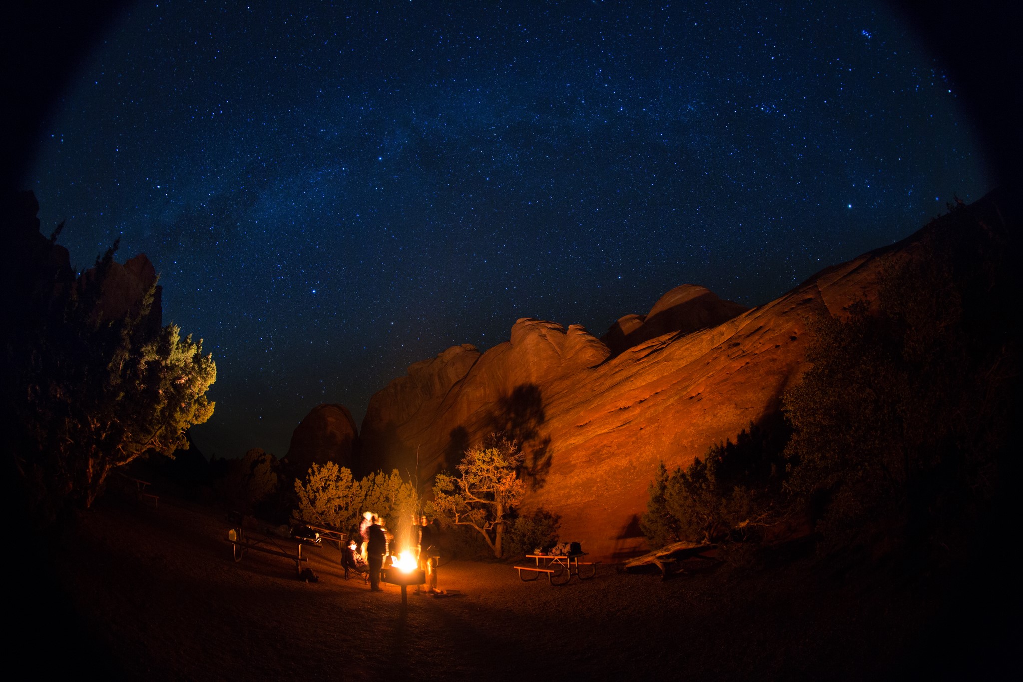
Photographer John Dale wrote: “We rolled in to Arches National Park to a beautiful sunset and got to our campsite just as it got dark, but that left us with a clear sky, plenty of stars, and a fire to warm up next to. Here’s a photo from the timelapse I took that night.”
From a photographer named John Dale, via Arches National Park’s Facebook page.
More:

Map of Arches National Park, Utah, United States showing predominant features such as arches, peaks, rivers and streams, mines, and roads. (Photo credit: Wikipedia)
Spread the word; friends don't allow friends to repeat history.
7 Comments | Camping, Outdoor Recreation, Time-lapse photography, Travel, Utah | Tagged: Arches National Park, Campfires, Camping, Outdoor Recreation, photography, Timelapse, Travel, Utah | Permalink
Posted by Ed Darrell
November 7, 2013

U.S. Mint‘s Acting Associate Director for Manufacturing, David Croft delivers his remarks. — in Custer, SD.
Interesting view of Mt. Rushmore on the new Mt. Rushmore Quarter.
Here’s David Croft, Acting Associate Director for Manufacturing of the U.S. Mint, introducing the coin yesterday in Custer, South Dakota.
(Wow; how much history is packed in that? Too little of it in the high school texts. Who is on Rushmore? Who made the sculptures on Rushmore, and when? After whom is Custer, South Dakota, named, and why?)
More:

Sign near Mt. Rushmore, South Dakota, informing travelers that the Alfred Hithcock film “North by Northwest” was partially filmed in the area (Photo credit: Wikipedia)
Spread the word; friends don't allow friends to repeat history.
Leave a Comment » | History, National Parks, Travel | Tagged: History, Mount Rushmore, National Parks, Numismatics, South Dakota, Travel, US Mint | Permalink
Posted by Ed Darrell
November 5, 2013
It’s a composite of 11 photographs to get the whole panoramic view — which just demonstrates that in photography it’s great to be lucky, but it usually takes great skill to get that amount of luck.
How much processing was involved, really?
Don’t worry, just check out the photo.

Double Moonbow, lava glow and fading Lunar Halo; 11-picture Panoramic taken on the rim of Kilauea’s Caldera On the Last Super Moon. Sean King, Atmospheric Phenomena
See the Facebook page for Hawaii Stargazing Adventures.
Click thumbnail for a larger image. 
Spread the word; friends don't allow friends to repeat history.
Leave a Comment » | Astronomy, National Parks, Nature, photography, Travel | Tagged: Astronomy, geography, Hawaii Stargazing Adventures, Kilauea, Nature, photography, Science, Sean King, Travel | Permalink
Posted by Ed Darrell
October 25, 2013
Or any other time of year.
From the Department of Interior Twitter feeds:
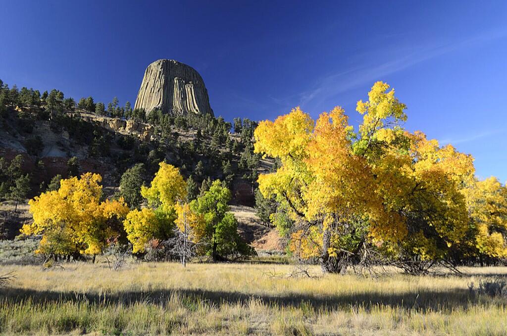
US Dept of Interior @Interior 16h Is there any doubt fall is best enjoyed in America’s great outdoors? Here’s great example from Devils Tower NM. pic.twitter.com/YRo1U8DSMQ
What do you think Richard Dreyfus thinks when he sees that? Stephen Spielberg?
“Devils Tower NM” means “National Monument,” not New Mexico. This volcano remnant stands in Wyoming.
Old friend, painter and photographer Nancy Christensen Littlefield offers a more close-up view.

Devil’s Tower on a July morning. Photo by Nancy Christensen LIttlefield.
And looking even closer, you spy Richard Dreyfus never-wanna-bes:

Climbers on Devils Tower. Photographer Nancy Littlefield said: “There were Native American prayer bundles along the trail around the base. It really is awe inspiring. Early morning gives you the best light to photograph it by.”
Devils Tower is the plug of an old volcano. What’s left is the magma that hardened, and what we see is left after the softer cone eroded away.
More:
Spread the word; friends don't allow friends to repeat history.
Leave a Comment » | Geography - Physical, geology, History, National Parks, Theodore Roosevelt, Travel | Tagged: Antiquities Act, Devils Tower, geography, geology, History, National Monuments, Travel | Permalink
Posted by Ed Darrell
October 23, 2013
We had to fight to keep this stuff in Texas science books.
Then, out on the street, I see a U-Haul truck.

U-Haul truck features geographic information, and geology information, about Arkansas and its Crater of Diamonds State Park.

Detail: U-Haul truck features a graphic description of the geology and information about Arkansas’s Crater of Diamonds State Park.
Well played, U-Haul. Can Texas catch up?
Update, October 24, 2013: Turns out U-Haul has a website that features all of the graphics they use on their trucks. I sense a geography or state history assignment in here, somewhere, social studies teachers. Reminds me of the animals that used to (still do?) grace the tails of Frontier Airlines airplanes, the Native American on the tails of Alaska Airlines, and other specific destination promoting tricks businesses have used over the years. Wish more businesses would do that.
http://twitter.com/SuperGraphic/status/393408729388834816
More:
Spread the word; friends don't allow friends to repeat history.
8 Comments | Geography - Physical, Geography - Political, geology, Science, Travel | Tagged: Arkansas, Crater of Diamonds State Park, Education, geography, geology, Science, Travel, U-Haul | Permalink
Posted by Ed Darrell
October 21, 2013
Utah has a Cache County, which includes most of the Cache Valley. In 7th grade Utah history, if not before, Utah kids learn that the name came from the old Mountain Men, French-descended fur trappers who plied the area well before the Mormon pioneers and even John C. Fremont.
A trapper could collect a half-ton of beaver pelts in a season, to sell to a large corporation to export to Europe to be made into felt. He wouldn’t want to carry that weight around with him. So trappers would make a place to hide their furs until trading time — a “cache” in fractured French, from the word “cacher,” which means “to hide,” in this case. (See also Colorado’s Cache la Poudre River.)
Utah’s Cache Valley at least one year hosted the grand rendezvous of fur trappers and their hosting corporate suppliers and buyers, and for much of a decade or longer was a place where fur trappers hid their furs awaiting the rendezvous — great American explorers and pioneers like Jedediah Smith, Jim Bridger, James Beckwourth, Peter Skene Ogden and Thomas Fitzpatrick.
Maybe the people who made this sign didn’t know that history. I found it in Alvarado, Texas, after all.
There is a world of difference between “cashing a check” and “caching a check,” though. Surely there is an Abbott and Costello-style comedy routine in this sign:

Check caching in Alvarado, Texas?
Six words on that sign. Three of them are misspelled, 50%.
I imagine someone entering the store to cash a check, handing it to the clerk who promptly drops it into a slot in a mysterious box and says, “All cached.” “Where’s my check?” the customer demands. Abbott and Costello enter from the back room.
Then I got stuck with an ugly earworm for the next few miles, with Tommy James infecting my brain. But for the want of an “e” it could have been the Beatles or Pink Floyd.
I hope the merchant got a heckuva discount from the sign maker. At least 50% off.

Cache Valley, Utah, in the late 19th or early 20th century; camp near the head of Cache Valley – NARA – 516657 via Wikipedia

Cache Valley, Utah, today, after an infusion of cash. Jim Bridger wouldn’t recognize the place. Wikipedia image
Spread the word; friends don't allow friends to repeat history.
2 Comments | History, Humor, Signs, Travel | Tagged: History, Humor, Signs, Travel | Permalink
Posted by Ed Darrell
October 18, 2013
Looks like snow to me. From the Department of Interior:

Fall colors have arrived at the Great Sand Dunes National Park. #nature #autumn #colorado pic.twitter.com/34RXSkuBLe
Spread the word; friends don't allow friends to repeat history.
1 Comment | Geography - Physical, Landmarks, National Parks, Travel | Tagged: Colorado, Department of Interior, geography, Great Sand Dunes NP, Land Forms, photography, Travel | Permalink
Posted by Ed Darrell
October 13, 2013
Our drive through central Texas and the Hill Country a few days ago provided some good fun and much needed break, though our destination was a memorial service for a friend who died very prematurely.
Kathryn noticed these odd signs first. I’m not sure of the purpose. These are in the information sign mode, the yellow diamonds used to warn drivers of hazards ahead.
The hazard? “Church.”
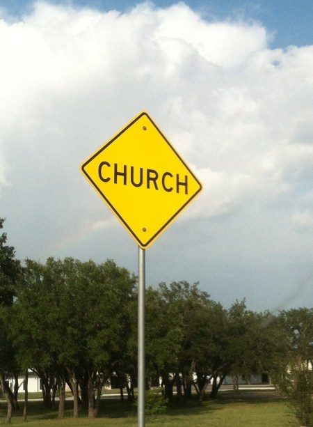
“Church” warning sign in Burnet, Texas
One might imagine these signs are posted to warn drivers on Sunday. About noon, when these churches’ services let out, the roads around them may be filled with people who are only too happy to go meet Jesus right now — so watch out! and drive accordingly.
Texas offers all sorts of strange things to those willing to drive the state’s highways, and see ’em.
More:
Spread the word; friends don't allow friends to repeat history.
4 Comments | Humor, Signs, Texas, Travel | Tagged: Church, Humor, Signs, Texas, Travel | Permalink
Posted by Ed Darrell
October 4, 2013
Photograph posted on Facebook by the Hawk Mountain Sanctuary Association:

Planning a trip to Hawk Mountain this weekend? Arrive early to enjoy great views of low-hanging fog and to see the sun peek out over the valley. It’s a great way to start any day. — with Quelia Paulino at Hawk Mountain Sanctuary Association.
More:
Spread the word; friends don't allow friends to repeat history.
Leave a Comment » | Bird Watching, Geography - Physical, Ornithology, Outdoor Recreation, Travel, Wildlife | Tagged: Bird Watching, geography, Hawk Mountain, Hawk Mountain Sanctuary, Ornithology, Outdoor Recreation, photography, Travel, Wildlife | Permalink
Posted by Ed Darrell
September 26, 2013
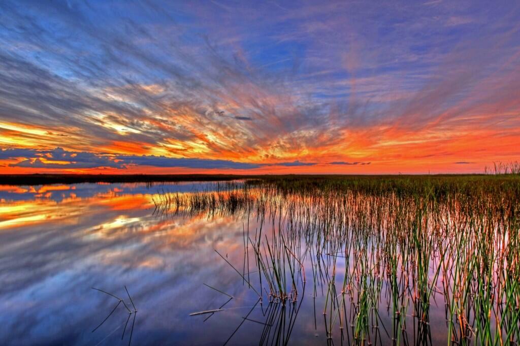
Caption from Interior’s Tweet: Sometimes there are no words to describe America’s public lands. This photo @EvergladesNPS proves it. #Florida pic.twitter.com/3l7fnrcfsG
Everglades National Park, in Florida, is a great example of wild lands that belong to all Americans, that we almost let slip away.
I’m not sure a painter could do a more stunning version of this view.
More:

Location map: Everglades National Park in red. Wikipedia photo
Spread the word; friends don't allow friends to repeat history.
Leave a Comment » | Geography - Physical, History, National Parks, photography, Travel | Tagged: Everglades National Park, Florida, geography, Nature, photography, Travel, Wilderness | Permalink
Posted by Ed Darrell
September 23, 2013
World and U.S. history classes should be long past this point, but the photo just recently surfaced:

From America’s Outdoors: Bering Land Bridge National Preserve – Gone are the shockingly bright pinks, yellows and purples of summer, replaced by deeper and darker reds, yellows, greens and the beginnings of brown, all of equal vibrancy and beauty. And soon, as the 34 degree weather and diminishing daylight would lead us to believe, a blanket of white will fall upon the landscape. Enjoy the change of seasons wherever you may be!
Bering Land Bridge National Preserve? Did you even know there was such a thing? Part of our public lands, your tax dollars at work.
Not a place for a Sunday drive. There are no roads to get to the place. For students, this site offers a lot of photos and interesting stuff for projects in history (human migrations) and geography (land forms, lava flows, migration routes, wilderness).
More:

Tors of Serpentine, in the Bering Land Bridge National Preserve, Alaska – NPS photo
Spread the word; friends don't allow friends to repeat history.
Leave a Comment » | Alaska, Geography - Physical, National Parks, Public Lands, Student projects, Travel, World history | Tagged: Alaska, Bering Strait, Beringia, geography, Land Forms, Tors, Travel, U.S. history, World history | Permalink
Posted by Ed Darrell
September 20, 2013
Were I teaching geography this year, I think I’d work hard to find some way to sneak this time-lapse piece into the curriculum somewhere.
The film maker has advice, and information (some links added):
RIO, from Scientifantastic
BEST VIEWED IN HD, FULLSCREEN, SCALING OFF
Follow me at:
Twitter – twitter.com/scientifantasti | Instagram – instagram.com/scientifantastic | Google+ – gplus.to/scientifantastic
I was lucky enough to be sent to Rio on assignment to shoot some 4K and 10K timelapse footage for a major electronics manufacturer. This video is a compilation of some of the footage I shot there. Most of the locations are within the city of Rio De Janeiro, but I also traveled to the famous Iguazú Falls on the border of the Brazilian state of Paraná and the Argentinian province of Misiones. In 2011 Iguazú Falls was announced as one of the seven winners of the New Seven Wonders of Nature by the New Seven Wonders of the World Foundation.
RIO DE JANEIRO
No wonder the beautiful city of Rio De Janeiro was chosen to host the 2014 FIFA World Cup and the 2016 Summer Olympics. Rio de Janeiro, or simply Rio, is the capital city of the State of Rio de Janeiro, the second largest city of Brazil, and the third largest metropolitan area and agglomeration in South America, boasting approximately 6.3 million people within the city proper. Part of the city has been designated as a World Heritage Site, named “Rio de Janeiro: Carioca Landscapes between the Mountain and the Sea”, identified by UNESCO in the category Cultural Landscape.
Rio de Janeiro is one of the most visited cities in the southern hemisphere and is known for its natural settings, carnival celebrations, samba, Bossa Nova, balneario beaches such as Barra da Tijuca, Copacabana, Ipanema, and Leblon. Some of the most famous landmarks in addition to the beaches include the giant statue of Christ the Redeemer (“Cristo Redentor”) atop Corcovado mountain, named one of the New Seven Wonders of the World; Sugarloaf mountain (Pão de Açúcar) with its cable car; the Sambódromo, a permanent grandstand-lined parade avenue which is used during Carnival; and Maracanã Stadium, one of the world’s largest football stadiums.
I hope you enjoy the video!
Camera Gear:
Canon 5DIII
Canon 5DII
PhaseOne IQ180
Various Canon lenses
Music By:
Jan Baumann – baumann-musik.de
Special thanks to:
My production assistant José Olímpio ( joseolimpio.com ). Without his help this video would not have been possible. If you are ever in Rio and need a local production person I highly recommend José.
Dynamic Perception – dynamicperception.com
Division Camera – divisioncamera.com
Digital Fusion – digitalfusion.net
Jag35 – jag35.com
YOU CAN FOLLOW ME AT:
Twitter – twitter.com/scientifantasti
Instagram – instagram.com/scientifantastic
Vimeo – vimeo.com/scientifantastic
Facebook – facebook.com/pages/Scientifantastic/163137190447579
Google+ – gplus.to/scientifantastic
500px – 500px.com/scientifantastic
ProPic – propic.com/scientifantastic
Those of you who have traveled to Rio, tell us: Does this short piece show off Rio as you would want it to be shown?
More:
Spread the word; friends don't allow friends to repeat history.
Leave a Comment » | Geography - Physical, South America, Time-lapse photography, Travel | Tagged: Brazil, geography, Rio de Janeiro, Scientifantastic, South America, Time-lapse photography, Travel, Vimeo | Permalink
Posted by Ed Darrell
September 3, 2013
Top of Colorado, anyway.
View from Longs Peak, yesterday:

View from Longs Peak, September 2, 2013; 14,259 ft. Photo by Xiang Li.
Xiang Li and James Darrell summited the mountain yesterday, a bit tougher climb than they had expected. No view like that comes without some great effort somewhere. They topped Grays Peak a couple of weeks ago — a slightly higher mountain (20 feet), but an easier climb.
Long’s Peak is the highest point in Rocky Mountain National Park.
Longs Peak is one of the 54 mountains with summits over 14,000 feet in Colorado.[3] It can be prominently seen from Longmont, Colorado, as well as from the rest of the Colorado Front Range. It is named after Major Stephen Long, who explored the area in the 1820s. Longs Peak is one of the most prominent mountains in Colorado, rising nearly 10,000 feet above the western edge of the Great Plains.
More:
Spread the word; friends don't allow friends to repeat history.
Leave a Comment » | Family, Geography - Physical, Hiking, Life, Outdoor Recreation, Travel | Tagged: Climbing, Family, geography, Hiking, Life, Longs Peak, Outdoor Recreation, Rocky Mountain National Park, Travel | Permalink
Posted by Ed Darrell
September 1, 2013
Spectacular photo of Glen Canyon Dam, in the early morning, with a thunderstorm to the north. This photo was taken close to the spot where Norman Rockwell painted the dam about 40 years ago.

Electricity is in the air at Glen Canyon! Although the Glen Canyon Dam produces hydroelectric power around the clock, an early morning thunderstorm really cranked up the voltage earlier this month. Use caution when planning your upcoming outdoor activities as intense thunderstorms are common this time of year. (Bureau of Reclamation/Interior Facebook entry; photo Credit: David Bailey)
More:

Norman Rockwell’s tribute to the Glen Canyon Dam. Bureau of Reclamation image
Spread the word; friends don't allow friends to repeat history.
Leave a Comment » | Colorado River, Electricity, Energy, Geography - Physical, photography, Rivers, Travel | Tagged: Colorado River, Energy, geography, Glen Canyon Dam, Rivers, Travel | Permalink
Posted by Ed Darrell


